
Community hub
Recent from talks
Contribute something
Nothing was collected or created yet.
Suomenlinna
View on Wikipedia
Suomenlinna (Finnish: [ˈsuo̯menˌlinːɑ]), or Sveaborg (Swedish: [ˈsvɛːɑˈborj]), is a sea fortress composed of eight islands, of which six have been fortified. Located about four kilometres (2.5 mi) southeast of the city center of Helsinki, Finland, Suomenlinna is a popular destination for both tourists and locals, who enjoy it as a picturesque picnic site.[1]
Key Information


Construction of the fortress began in 1748 under the Swedish Crown as a defense against Russia. The general responsibility for the fortification work was given to Admiral Augustin Ehrensvärd. The original plan of the bastion fortress was heavily influenced by Vauban, a renowned French military engineer, and incorporated the principles of the star fort style of fortifications, albeit adapted to a group of rocky islands.
During the Finnish War, Russian forces besieged the fortress in 1808. Despite its formidable reputation as the "Gibraltar of the North", the fortress surrendered after only two months, on 3 May 1808. Its loss paved the way for Russia's occupation of Finland in 1809, and the subsequent establishment of the Grand Duchy of Finland, an autonomous state within the Russian Empire.
Under Russian rule, the fortress served as a base for the Baltic Fleet during World War I, and in 1915, construction began on the Krepost Sveaborg defense system. Russian forces abandoned the fortress after Finland declared independence in 1917. Originally named Sveaborg ("Fortress of Sweden") and known as Viapori ([ˈviaˌpori]) in Finnish, it was renamed Suomenlinna ("Fortress of Finland"[2]) in 1918. In Swedish, however, it retains its original name. In the aftermath of the Finnish Civil War, the islands housed the Suomenlinna prison camp for captured Red soldiers.
Suomenlinna remained under the control of the Finnish Defense Department until 1973, when most of it was transferred to civilian administration. Famous for its bastion fortifications, the fortress was designated a UNESCO World Heritage Site in 1991.[2]
Geography
[edit]
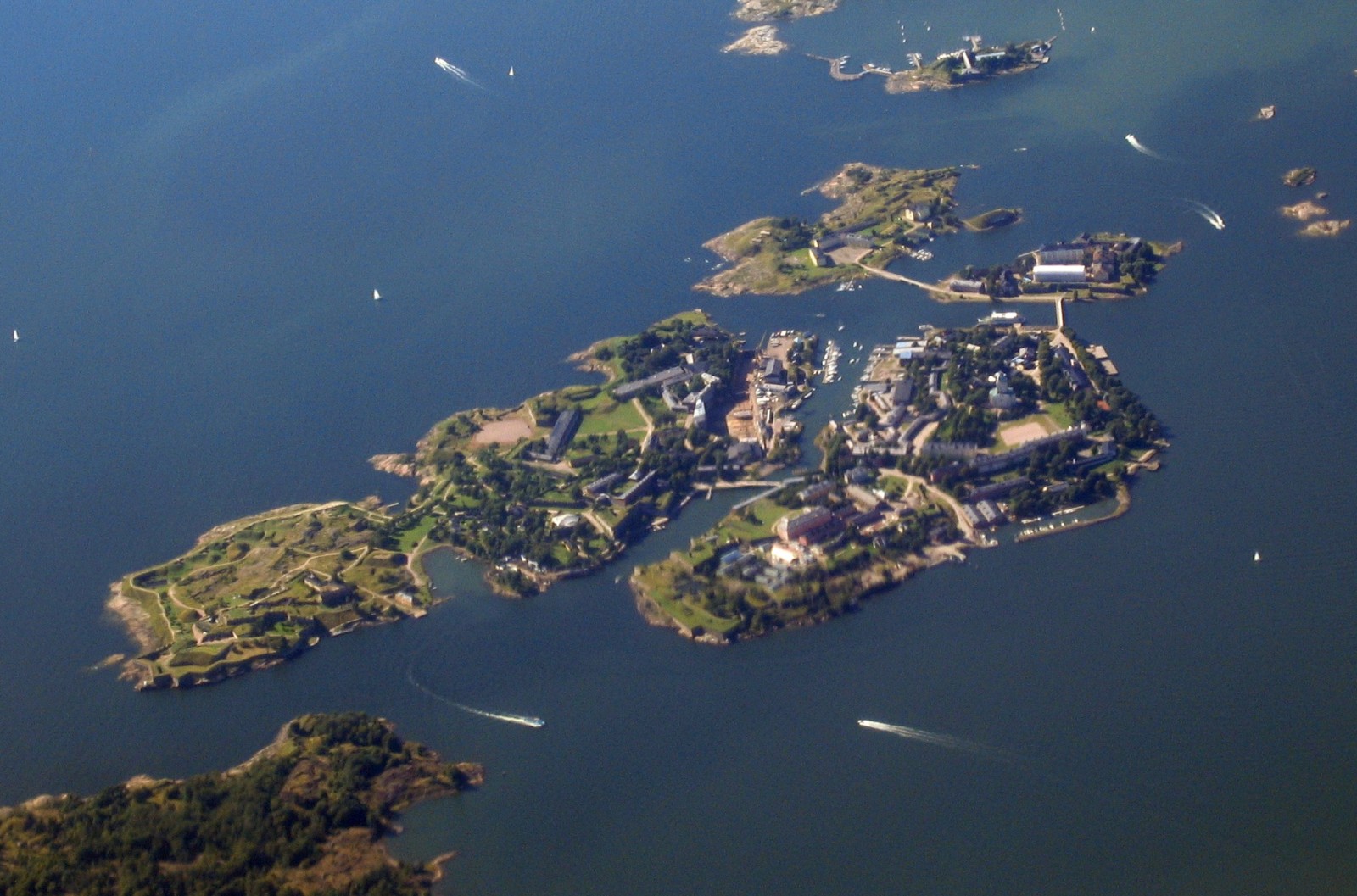
The Suomenlinna district of Helsinki lies southeast of downtown Helsinki and consists of eight islands. Five of the islands are connected by either bridges or a sandbar landbridge. Länsi-Mustasaari (Västersvartö) is bridged to Pikku Mustasaari (Lilla Östersvartö), which is bridged to Iso Mustasaari (Stora Östersvartö), which, in turn, is bridged to Susisaari (Vargö). Susisaari was connected to Susiluoto (Vargskär) by filling in the separating waterway during the Russian period. This island, which has the greatest concentration of fortifications was renamed Gustavssvärd (Kustaanmiekka, meaning "Gustav's sword") during the construction by Sweden. The three unconnected islands are Särkkä (Långören), Lonna (Lonnan), and Pormestarinluodot (Borgmästargrundet). The total land area of the district is 80 hectares (0.80 square kilometres; 0.31 square miles).
Instead of following the standard Finnish postal addressing system, which uses a street name and house number, addresses in Suomenlinna use a letter code for the island followed by a house number. For instance, "C 83" refers to house number 83 on Iso-Mustasaari (designated by the letter "C"). The postal code for the Suomenlinna district is 00190.
History
[edit]Swedish era
[edit]
Background
[edit]Early on in the Great Northern War, Russia took advantage of Swedish weakness in Ingria (sv: Ingermanland) and captured the area near the Neva River as well as the Swedish forts, Nyen and Nöteborg, built to protect it. In 1703, Peter the Great founded his new capital, Saint Petersburg, in that easternmost corner of the Gulf of Finland. In the approach to it he built the fortified naval base of Kronstadt. Russia soon became a maritime power and a force to be reckoned with in the Baltic Sea. The situation posed a threat to Sweden, which until that time had been the dominant power in the Baltic. This was visibly demonstrated by the use of naval forces in the Russian capture of Viborg in 1710. The main Swedish naval base at Karlskrona was too far to the south to meet Sweden's new needs for its navy in the 18th century, which often resulted in Swedish ships reaching the coast of Finland only after Russian ships and troops had either started or completed their spring campaigns.[3]
The lack of coastal defenses was keenly felt with Russian landings in Helsingfors in the spring of 1713 and the Swedish failure to blockade the Hanko Peninsula in 1714. A Russian naval campaign against the Swedish coast towards the end of the Great Northern War further outlined the need to develop Finnish coastal defenses. Immediately after the war ended the first plans were set in motion in Sweden to construct an archipelago fleet and a base of operations for it in Finland. However, nothing with regard to Sveaborg took place until the end of Russo-Swedish War of 1741–1743. Fortifications were left unfinished at Hamina and Lappeenranta while Hämeenlinna was being built into a supply base. Lack of funds, unwillingness to devote funds for defending Finland, and the belief (arising just before the war) that Russia would be pushed away from the Baltic Sea were the main causes for the lack of progress.[4]
The following Russo-Swedish War of 1741–1743, which quickly turned from a Swedish attack into a Russian occupation of Finland, again underlined the importance of developing fortifications in Finland. Lack of base of operations for naval forces made it difficult for the Swedish navy to operate in the area.[5] Other European states were also concerned about developments regarding Russia, especially France, with whom Sweden had concluded a military alliance. After lengthy debate, the Swedish parliament decided in 1747 to both fortify the Russian frontier and establish a naval base at Helsingfors as a counter to Kronstadt. Augustin Ehrensvärd (1710–1772), a young lieutenant colonel, was given the responsibility of designing the fortresses and directing construction operations.


Construction
[edit]Sweden started building the fortresses in January 1748. Ehrensvärd's plan contained two fortifications: a sea fortress at Svartholm near the small town of Lovisa,[6] and a larger sea fortress and naval base (Sveaborg) at Helsingfors. There were two main aspects to Ehrensvärd's design for Sveaborg: a series of independent fortifications across several linked islands and, at the very heart of the complex, a navy dockyard. In addition to the island fortress itself, seafacing fortifications on the mainland would ensure that an enemy could not acquire a beach-head from which to stage attacks on the sea fort. The plan was also to stock munitions for the whole Finnish contingent of the Swedish Army and Royal Swedish Navy there. Additional plans were made for fortifying the Hanko Peninsula, but these were postponed.
Construction started in early 1748 kept expanding, and by September there were around 2,500 men building the fortresses. Initially the soldiers were housed in the vaults of the fortifications, while the officers had specially built quarters integrated into the baroque cityscape composition of the overall plan. The most ambitious plan was left only half completed: a baroque square on Iso Mustasaari partly based on the model of Place Vendôme in Paris. As the construction work progressed, more residential buildings were built, many following the shape of the fortification lines. Ehrensvärd and some of the other officers were keen artists who made oil paintings presenting a view of life in the fortress during its construction, and giving the impression of a lively "fortress town" community.

Due to repeated Russian threats in 1749 and 1750, more effort was placed on the island fortifications at the expense of those on the mainland, so that a safe base of operations could be secured for the Swedish naval units along the Finnish coast. Using the military garrisoned in Finland as the workforce, construction continued with over 6,000 workers in 1750. Fortifications at Gustavssvärd were completed in 1751 and the main fortifications on Vargö were ready in 1754. The fortress was fully operational though unfinished. These accomplishments did not reduce the pace of construction and in 1755 there were 7,000 workers constructing the fortifications outside of Helsingfors which at the time had around 2,000 residents. The substantial fortification work on the islands south of the town brought it a new and unexpected importance. Swedish participation to the Seven Years' War halted the construction efforts in 1757, which also marked the end of the rapid construction phase of Sveaborg.[7]
This period in Swedish history was known as the Age of Liberty, during which the kingdom was under increased parliamentary control, divided into two political parties, the Hats and the Caps. Ehrensvärd had been supported by the Hats, so when the Caps rose to power in 1766 he was relieved of his post and replaced with ardent Caps supporter Christopher Falkengréen. However, after 1769 when the Hats regained power, Ehrensvärd was again placed in command of the Swedish archipelago fleet in Finland, officially the arméens flotta ("fleet of the army"), and returned to Sveaborg. But additional progress had not been made on the fortifications when Ehrensvärd died in 1772. Efforts to improve the fortress continued under Jacob Magnus Sprengtporten, but his tenure was cut short by disagreements with King Gustav III. Once again efforts slowed down as garrisons were reduced, and in 1776 Sveaborg's commander reported that he could not even man one-tenth of the artillery placed in the fort. Even at the start of the Russo-Swedish War in 1788 Sveaborg remained in an incomplete state.[8]
Facilities for constructing ships for the Swedish archipelago fleet were built at Sveaborg in the 1760s. In 1764 the first three archipelago frigates were launched from there.[9] In addition to the construction of the fortifications and ships, naval officer training was started by Ehrensvärd at his own expense at Sveaborg in 1770. It took until 1779 before a naval military school was formally founded there.[10]
Service
[edit]

Sveaborg was formed and stocked according to the needs of the Swedish archipelago fleet and thus was unable to repair and refit the Swedish battlefleet after the battle of Hogland. Facilities were also found lacking at Sveaborg, especially in the areas intended for taking care of the sick and wounded. Russian control of the waters outside of Sveaborg practically blockaded the Swedish battlefleet to Sveaborg. By cutting the coastal sea route past Hangö, Russians prevented supplies from being shipped from Sweden to Sveaborg. The Swedish fleet finally managed to set sail for its base at Karlskrona on 20 November when the Baltic Sea had already frozen severely enough that ice had to be sawed open before some ships could move. The fleet could not overwinter at Sveaborg since it lacked the facilities and supplies for fitting the ships.[11]
While the route to Sweden was open again in late 1788 and in early 1789, Russian ships cut the connection from Sveaborg to Sweden by forming a blockade at Porkkala cape. Sveaborg was the most important location for archipelago fleet's ship construction and fitting during the war. Even so, and despite efforts, several ships remained unfinished at Sveaborg until the end of the war. The importance of Sveaborg did not escape the Russians whose broad operational plan for 1790 included a siege of Sveaborg both from sea and land.[12]
Following a pact between Alexander I and Napoleon, Russia launched a campaign against Sweden and occupied Finland in 1808. The Russians easily took Helsingfors in early 1808 and began bombarding the fortress.[13] Its commander, Carl Olof Cronstedt, negotiated a cease-fire. When no Swedish reinforcements had arrived by May, Sveaborg, with almost 7,000 men, surrendered. The reasons for Cronstedt's actions remain somewhat unclear; but the hopeless situation, psychological warfare by the Russians, some (possibly) bribed advisors, fear for the lives of a large civilian population, lack of gunpowder, and their physical isolation are some likely causes for the surrender. By the Treaty of Fredrikshamn in 1809, Sweden ceded its eastern territory of Finland and the Grand Duchy of Finland was established within the Russian Empire. The Swedish period in Finnish history, which had lasted some seven centuries, came to an end. As of 2024, nine wrecks were known to be in the vicinity, possibly part of the fleet at the fortress. At the time of the surrender in 1808, more than 100 ships changed nationality.[14]

Under Russian rule
[edit]After taking over the fortress, the Russians started an extensive building program, mostly extra barracks, and extended the dockyard and reinforced the fortification lines. The long period of peace following the transfer of power was shattered by the Crimean War of 1853–56. The French–British–Ottoman alliance decided to engage Russia on two fronts and sent an Anglo-French fleet to the Baltic Sea. For two summers during the Åland War the fleet shelled the towns and fortifications along the Finnish coast. The bombardment of Sveaborg (also known then as Viapori) by the forces of Richard Saunders Dundas and Charles Pénaud on 9–10 August 1855 lasted 47 hours and the fortress was badly damaged, but they were unable to knock out the Russian guns. After the bombardment, the Anglo-French fleet sent no troops ashore and instead set sail for Kronstadt.
After the Crimean War extensive restoration work was begun at Sveaborg. A new ring of earthworks with artillery emplacements was built at the western and southern edges of the islands.
The next stage in the arming of Sveaborg and the Gulf of Finland came in the build-up to World War I. The fortress and its surrounding islands became part of "Peter the Great's naval fortification" designed to safeguard the capital, Saint Petersburg.
Finnish ownership
[edit]
Following the Russian Revolution in 1917, Finland declared independence, but Sveaborg remained under the control of Russian military forces. During the Finnish Civil War, they handed part of it over to the Finnish Red Guard in March 1918. The Whites captured the fortress with the support of German forces in early April. Sveaborg received its current name, Suomenlinna ("Castle of Finland"), on May 12, 1918, when the red-yellow lion flag—used temporarily as Finland's national flag—was ceremoniously raised on the flagpole of Gustavssvärd, and eight salutes were fired from two Russian field cannons.[16][17] The flag-raising ceremony was attended by distinguished guests, including members of the Senate, the city council, and several high-ranking military officers. The name change of the fortress was proposed by Senator Kyösti Kallio.[18]
In 1918 and 1919, the islands housed a large prison camp in the aftermath of the civil war. Of the 10,000 Red Guard prisoners held at the Suomenlinna prison camp, over 1,000 died of hunger and disease. Eighty prisoners were executed.[19]
After the civil war, the fortress functioned as a Finnish garrison. A coastal artillery regiment, the Naval Academy, and a base for the mine-sweeping fleet were stationed on the islands. There were small-scale restoration efforts, and interest in the fortress as a tourist destination started to grow. During the Winter War in 1939–1940, Suomenlinna housed anti-aircraft and artillery units and served as a base for the submarine fleet. During the Continuation War, German military forces were stationed in Suomenlinna. The fortress sustained damage from bombings.[20]
After the war, the Valmet Shipyard at Suomenlinna built barges and trawlers as war reparations. It also constructed vessels for the Finnish Navy and Coast Guard, and repaired ships. For the 200th anniversary of the fortress in 1948, the courtyard of Susisaari (Vargö) Castle and Kustaanmiekka (Gustavssvärd) were restored.[20]
No longer very practical as a military base, Suomenlinna was turned over to civilian administration in 1973. An independent government department, the Governing Body of Suomenlinna, was formed to administer the unique complex. At the time there was some debate over its Finnish name, with some suggesting that the old name Viapori be restored, but the newer name was retained. The presence of the military on the islands has been drastically scaled down in recent decades. The Suomenlinna garrison houses the Naval Academy (Finnish: Merisotakoulu) of the Finnish Navy on Pikku Mustasaari. Suomenlinna still flies the war flag, or the swallow-tailed state flag of Finland.
Present day
[edit]
Suomenlinna is now one of the most popular tourist attractions in Helsinki as well as a popular picnicking spot for the city's inhabitants. In 2009, a record 713,000 people visited Suomenlinna, most between May and September.[21] A number of museums exist on the island, as well as the last surviving Finnish submarine, Vesikko.


There are about 900 permanent inhabitants on the islands, and 350 people work there year-round.
There is a minimum-security penal labor colony (Finnish: työsiirtola) in Suomenlinna, whose inmates work on the maintenance and reconstruction of the fortifications. Only volunteer inmates who pledge non-use of controlled substances are accepted to the labour colony.
For the general public, Suomenlinna is served by ferries all year, and a service tunnel supplying heating, water and electricity was built in 1982. In the beginning of the 1990s, the tunnel was modified so that it can also be used for emergency transport.
Transport to and from the island is generally ceased between the hours of 0300 and 0600 daily, but is otherwise regular and frequent.[22]
Suomenlinna has been known as a location for avant-garde culture. In the mid-1980s, the Nordic Arts Centre was established on the island. Several buildings have been converted into artists' studios, which are let by the administration at reasonable rates. During the summer there is an art school for children. The performances of the Suomenlinna summer theater regularly draw full houses.
Between 2 and 6 September 2015, the Finnish postal service ran a test of the use of drones to deliver parcels between Helsinki and Suomenlinna. The parcels were limited to 3 kg (7 lb) or less, and flights were under the control of a pilot.[23]
The island houses a backpackers' hostel operating in a converted school building, built in 1908 and having served as a Russian school (1909-1917), military office (1918-1919), Finnish school (1920-1959), and a canteen and entertainment venue for soldiers (1959-1972).
Suomenlinna Church, built in 1854, was adapted in 1929 to include a lighthouse beacon.[24] Both the church and beacon are still active today.[25][24] The lighthouse beacon was modernised to use LED lighting in 2019.[26]
Timeline
[edit]
- 1748: Building of Sveaborg begins under command of Augustin Ehrensvärd.
- 1808: Sveaborg surrenders to Russia without any opposition during the Finnish War.
- 1809: Treaty of Fredrikshamn: Finland becomes part of Russia.
- 1855: Crimean War: Anglo–French navy bombards Sveaborg and causes substantial damage.
- 1906: Sveaborg Rebellion: Russian soldiers plan to depose the tsar.
- 1914–1917: A ring of ground and sea fortifications, called Krepost Sveaborg, is built around Helsinki.
- 1917: Finland becomes independent after the Russian Revolution.
- 1918: Name Suomenlinna becomes the official name of the fortress in Finnish. Prison camp of Red rebels is located in Suomenlinna after the Finnish Civil War.
- 1921 Valtion lentokonetehdas (State Aircraft Factory) started building airplanes and powered ice sleighs in Suomenlinna for the Finnish Air Force. In 1936 the factory moved to Tampere.
- 1973: Suomenlinna becomes civil administration area.
- 1991: Suomenlinna becomes a UNESCO World Heritage Site.

In literature
[edit]The Finnish-Swedish poet Johan Ludvig Runeberg wrote a poem called Sveaborg, one of the 35 short poems that together constitute his epic The Tales of Ensign Stål. It includes the following two verses about the fortress, which allude specifically to the "Gustav's Sword" (Gustavssvärd) bastion and its guns:
It looks out over sea and fjord,
With eyes of granite.
It raises its Gustav's sword high,
And proudly says: 'Come hither!'
This sword is not lowered to strike,
It only flashes and so destroys.
Do not let the island be defiantly approached
When the war comes.
Do not disturb the queen of the sea
In her moment of anger:
She slings messages of death toward you,
In the roar of a thousand cannons.[27]
Sveaborg is also mentioned in the lyrics of Gunnar Wennerberg's 1849 hymn O Gud, som styrer folkens öden ("Oh God, who steers the people's fate"), in which Sweden's "age-old freedom" is described as being "...our protection in gloomy dangers, our consolation in every bleached sorrow, our defence against the hegemon's forces, and stronger than Sveaborg".[28] As these words were written forty years after the Swedish cession of Finland to Russia, the use of Sveaborg as a simile has deliberately historic overtones.
George R. R. Martin wrote a short story about the surrender of Sveaborg, "The Fortress", when he was a college student. It was published in his 2007 volume of short stories, Dreamsongs.[non-primary source needed]
See also
[edit]Sources
[edit]References
[edit]- ^ Set sail for Suomenlinna: a quick intro
- ^ a b "Fortress of Suomenlinna". UNESCO World Heritage Centre. United Nations Educational, Scientific, and Cultural Organization. Retrieved 19 September 2021.
- ^ Mattila (1983), pp. 13–17, 27–47.
- ^ Mattila (1983), pp. 54–55, 57–59.
- ^ Mattila (1983), pp. 74–75.
- ^ Mattila (1983), pp. 80–85.
- ^ Mattila (1983), pp. 89–91.
- ^ Mattila (1983), pp. 105–116.
- ^ Mattila (1983), p. 104.
- ^ Mattila (1983), pp. 122–125.
- ^ Mattila (1983), pp. 138–155.
- ^ Mattila (1983), pp. 155–193.
- ^ Carl Nordling, L. "Capturing 'The Gibraltar of the North': How Swedish Sveaborg was taken by the Russians in 1808." Journal of Slavic Military Studies 17.4 (2004): 715–725.
- ^ From forest to sea Minna Koivikko, Vrak Magazine #1 (2024) at 41
- ^ Photographer Wendelin Kaarlo August. "Suomenlinna (Kustaanmiekka, bastioni Zander), punainen leijonalippu". www.finna.fi. Retrieved 7 January 2020.
- ^ "Bastioni Zander". Suomenlinnan viralliset sivut (in Finnish). Retrieved 14 March 2025.
- ^ Matti Klinge (1982). Suomen sinivalkoiset värit, Kansallisten ja muidenkin symbolien vaiheista ja merkityksistä. Otava. pp. 34–35. ISBN 951-1-06877-6.
- ^ Jarmo Nieminen (2012). Santahamina - sinivalkoinen saari. Maanpuolustuskorkeakoulu and Jarmo Nieminen. p. 68. ISBN 978-951-25-2360-3.
- ^ "Vankileiri 1918". Suomenlinnan viralliset sivut (in Finnish). Retrieved 14 March 2025.
- ^ a b "Suomalainen varuskunta". Suomenlinnan viralliset sivut (in Finnish). Retrieved 14 March 2025.
- ^ Helsingin sanomat (Finnish)
- ^ "Services - Travelling - HSL".
- ^ Reuters – "Finnish post office tests drone for parcel delivery" -accessed 15 September 2015.
- ^ a b "Suomenlinna Church". Atlas Obscura. Retrieved 1 July 2024.
- ^ "Suomenlinnan kirkko tarjoaa puitteet seurakunta- ja perhetilaisuuksille". Helsingin seurakunnat (in Finnish). Retrieved 1 July 2024.
- ^ Marine, Sabik. "Suomenlinna sea fortress lighthouse modernized to led technology". media.sabik.com. Retrieved 1 July 2024.
- ^ Den blickar över hav och fjärd // Med ögon i granit // Den lyfter högt sitt Gustavssvärd // Och menar stolt: 'Kom hit!'// Det svärdet sänks ej för att slå // Det blixtrar blott och krossar så // Låt bli att trotsigt nalkas ön // Då kriget gör sin rund // Stör icke drottningen av sjön // I hennes vredes stund:// Hon slungar mot dig dödens bud // I tusende kanoners ljud.
Runeberg, Johan Ludvig (1848). Sveaborg. - ^ Den är vårt skydd i mulna faror,// vår tröst i varje bleklagd sorg,// vårt värn mot övermaktens skaror// och starkare än Sveaborg.
Hedenblad Ivar, ed. (1883). Studentsången: vald samling af fyrstämmiga körer och qvartetter för mansröster (PDF). Stockholm: Hirsch. pp. 170–172.
Bibliography
[edit]- Mattila, Tapani (1983). Meri maamme turvana [Sea safeguarding our country] (in Finnish). Jyväskylä: K. J. Gummerus Osakeyhtiö. ISBN 951-99487-0-8.
External links
[edit]- Suomenlinna official site
- Suomenlinna Historical Society Official Site
- Photographs from Suomenlinna
- Fortifications of Suomenlinna Archived 7 June 2011 at the Wayback Machine
- More information on Suomenlinna
- Panoramic view of the King's Gate in Suomenlinna
- Sveaborg at Northern Fortress
- Suomenlinna Video
- Picturesque walking tour at Suomenlinna
- Video of driving through the Suomenlinna service tunnel on YouTube
- Link to satellite imagery of fortifications at Suomenlinna, via Google
- The Association of Castles and Museums around the Baltic Sea

| ||

| International | |
|---|---|
| National | |
| Other | |
Suomenlinna
View on GrokipediaGeography and Setting
Islands and Topography
Suomenlinna spans six principal islands in the inner archipelago of Helsinki, located approximately 4 kilometers southeast of the city center in the Gulf of Finland. These islands—Kustaanmiekka, Susisaari, Iso-Mustasaari, Pikku-Mustasaari, Länsi-Mustasaari, and Långören—cover a total land area of about 80 hectares within a broader 210-hectare zone that includes surrounding waters and smaller islets.[3][1] The five innermost islands are linked by bridges and causeways, facilitating movement while preserving the maritime defensive layout.[4] The islands exhibit typical Baltic Sea archipelago topography, characterized by glaciated rocky terrain with exposed granite bedrock, low elevations rarely exceeding 20 meters, and rugged coastal cliffs. This natural landscape, shaped by post-glacial rebound and erosion, provided strategic advantages for fortification, as structures were integrated directly into the contours to maximize defensive coverage. Local stone was quarried on-site for building, resulting in seamless blends of natural rock faces and engineered bastions, ravelins, and sea walls totaling 6 kilometers in length.[5][1][6] Kustaanmiekka, the outermost island, functions primarily as a breakwater with artificial extensions and low-lying reefs, while Susisaari serves as the central hub with higher ground supporting barracks and administrative buildings. Iso-Mustasaari and Pikku-Mustasaari feature compact, hilly profiles suited for artillery emplacements, and the smaller Länsi-Mustasaari and Långören include sheltered coves and tunnels carved into the rock for storage and defense. Overall, the topography's irregularity—combining shallow bays, narrow straits, and elevated vantage points—dictated the bastioned trace design, emphasizing enfilade fire over flat expanses.[3][1]Strategic Maritime Position
Suomenlinna occupies a cluster of six islands, collectively known as the Susiluodot, situated at the mouth of Helsinki Harbour in the Gulf of Finland, roughly 1 kilometre southwest of the mainland and 4 kilometres from the city centre.[2] This location was chosen for its commanding oversight of eastern maritime approaches in the Baltic Sea, enabling control over shipping lanes and naval movements toward Helsinki.[1] The islands' irregular topography and interconnected layout formed a natural defensive archipelago, fortified to create overlapping fields of fire from artillery emplacements that could engage enemy vessels attempting to bypass the harbour entrance.[1] Positioned strategically between Sweden's Baltic possessions and Russia's expanding influence, particularly from the Kronstadt base, the site served as a bulwark to prevent Russian fleets from establishing dominance in the gulf or launching assaults on the Swedish-held Finnish coast.[7] As the primary base for the Swedish Archipelago Fleet from 1748, Suomenlinna's maritime position facilitated rapid deployment of galleys and warships to patrol and contest Russian incursions, underscoring its role in Sweden's post-Great Northern War defensive strategy amid repeated conflicts with Russia in the early 18th century.[2] The fortress's design integrated land and sea defenses over 210 hectares, with over 6 kilometres of walls and batteries optimized for the archipelago environment to secure trade routes and deny adversaries a foothold near the capital of the Swedish province.[1]Origins and Strategic Rationale
Pre-Construction Geopolitical Context
Sweden's imperial decline in the Baltic region accelerated after the Great Northern War (1700–1721), in which Russia seized eastern fortresses like Narva and established naval dominance, though Finland stayed under Swedish sovereignty, necessitating reinforced defenses against persistent Russian pressure.[2] The subsequent Russo-Swedish War (1741–1743, launched by Sweden's interventionist Hats faction to recover prior losses, culminated in Swedish military setbacks and the Treaty of Åbo on 7 August 1743, forcing the cession of Kymmene County—including Lappeenranta, Hamina, and lands east of the Kymijoki River—to Russia, thereby shortening the buffer zone and heightening threats to central Finland.[8][9] These territorial concessions exposed Swedish supply lines and the Gulf of Finland approaches to Stockholm, amplifying the strategic urgency for a robust naval stronghold to counter Russia's expanding fleet and land forces, which had demonstrated invasion capabilities during the recent conflict.[10] In 1747, recognizing Finland's frontline role in the rivalry, the Swedish Riksdag authorized a comprehensive fortification project at Helsinki, envisioned as a central base for army and fleet operations to deter further incursions and restore deterrence in the eastern Baltic.[2] This decision underscored Sweden's causal prioritization of maritime fortification over land borders, given Russia's historical reliance on amphibious assaults in prior wars, positioning the Helsinki archipelago as a chokepoint for defending the realm's core territories amid an era of imperial competition.[10]Decision and Initial Planning
In 1747, Sweden's parliament (Riksdag) resolved to fortify its eastern territories by constructing a central naval base and fortress near Helsinki, alongside a secondary border fortress at Degerby (modern Loviisa), in response to vulnerabilities exposed by prior losses to Russia during conflicts like the Great Northern War.[2] This decision prioritized the Susiluodot island group—later unified under the name Suomenlinna—at Helsinki's harbor entrance, leveraging their natural barriers to deter naval incursions and secure the Gulf of Finland approaches.[2] The initiative allocated significant resources, aiming for rapid completion within four years, though fiscal constraints and shifting priorities soon necessitated adjustments.[2] Command of the project was assigned to Augustin Ehrensvärd, a Swedish artillery lieutenant colonel appointed as fortress governor, who oversaw initial site surveys and design from 1748 onward.[11] Ehrensvärd's blueprint envisioned an interconnected bastion network spanning the islands, emphasizing mutual defensive support through star-shaped forts, casemates, and artillery emplacements to command sea lanes and repel amphibious assaults.[12] Influenced by contemporary European engineering, the plan integrated terrain adaptation—such as rock-cutting for batteries—with logistical elements like barracks and a dry dock for the Swedish Archipelago Fleet, positioning Sveaborg as a pivotal hub for regional power projection.[12] By 1750, the complex was formally designated Sveaborg ("Sweden's fortress"), underscoring its national strategic primacy, though early phases focused on core island linkages rather than expansive landward extensions due to resource prioritization toward maritime threats.[2] These foundational plans laid the groundwork for what became Europe's largest 18th-century sea fortress, though incomplete execution reflected Sweden's broader military overextension.[2]Construction and Development
Engineering and Architectural Design
The engineering and architectural design of Suomenlinna, originally Sveaborg, was directed by Swedish Admiral Augustin Ehrensvärd starting in 1748, adapting Sébastien Le Prestre de Vauban's bastion fortification principles to the fragmented island topography off Helsinki's coast.[1] This approach emphasized low-profile bastions carved directly into bedrock to reduce seaward visibility while enabling overlapping fields of fire, forming a polygonal trace that eliminated dead angles in defense.[1] The design integrated natural features like cliffs and channels, creating a chain of mutually supporting fortifications across the islands rather than a single enclosed structure.[1] Construction relied on local granite quarried from the site, with labor provided by over 6,500 conscripted Finnish and Swedish soldiers who excavated and built using manual tools and gunpowder for blasting.[1] By 1750, a pioneering dry dock was operational on the main island for shipbuilding and repairs, supporting the Swedish Archipelago Fleet with capacities for vessels up to 74 guns.[2] Defensive walls totaled 6 kilometers by completion, enclosing barracks, warehouses, and casemates within a bastioned perimeter that spanned 210 hectares.[1] Engineering innovations included subterranean passages and caponiers for troop movement under fire, alongside ravelins and counterguards to extend bastion flanks against enfilade attacks.[1] The overall system, finalized by the late 18th century, incorporated 7 kilometers of earthworks and ramparts armed for 1,395 cannons and 154 mortars, prioritizing endurance against naval bombardment through dispersed, terrain-blended profiles.[13] This maritime-adapted bastion model exemplified 18th-century European military engineering, balancing offensive reach with defensive redundancy in an exposed sea environment.[1]Key Builders and Innovations
The primary architect and overseer of Suomenlinna's construction, originally Sveaborg, was Swedish Admiral Augustin Ehrensvärd, who directed the project from its start in 1748 until his death in 1772.[14] Appointed by the Swedish Crown to fortify the Gulf of Finland against Russian threats, Ehrensvärd, an artillery expert, coordinated thousands of soldiers, prisoners, and craftsmen in building the complex across six islands.[15] His leadership made Sveaborg Sweden's largest 18th-century construction endeavor, emphasizing a blend of defensive bastions and naval infrastructure.[5] Ehrensvärd's design innovations centered on adapting bastion fortification principles to a maritime environment, creating independent yet interconnected island defenses with artillery batteries positioned for crossfire coverage.[16] A key feature was the integration of a dry dock and shipyard within the fortress, enabling on-site warship construction for the Archipelago Fleet and supporting logistical self-sufficiency through attached barracks, arsenals, and warehouses.[14] This naval-centric approach marked a departure from purely land-based fortresses, prioritizing rapid deployment of vessels alongside static defenses.[10] Collaborators included architect Carl Hårleman, who designed elements like the Great Courtyard in the 1760s, incorporating neoclassical influences into the military layout.[17] Ehrensvärd's scalable planning allowed phased expansion, starting with core islands and adapting to rocky topography without excessive earthworks, which conserved resources amid Sweden's fiscal constraints.[18] These elements collectively positioned Sveaborg as a prototype for integrated sea fortresses in Northern Europe.Military History
Swedish Operational Use
Sveaborg functioned primarily as a fortified naval base for Sweden's Archipelago Fleet from the late 1750s onward, supporting the maintenance, construction, and deployment of galleys and other shallow-draft vessels designed for Baltic coastal operations.[2] The fortress included shipyards where components for archipelago fleet vessels were produced starting in the 1760s, with the first such ships launched around 1764, enabling rapid mobilization against Russian threats to Finland's archipelago.[16] Its strategic position facilitated the protection of Swedish supply lines and the flanking of land armies, embodying Augustin Ehrensvärd's vision of an integrated sea-land defense system.[1] The garrison at Sveaborg grew to encompass several infantry and artillery regiments, totaling approximately 7,000 troops by April 1808, equipped with hundreds of cannons across its island bastions.[19] This force, supported by dry docks and logistical infrastructure, positioned the fortress as Sweden's premier defensive outpost in the eastern Baltic, often termed the "Gibraltar of the North" for its reputed impregnability against naval assault.[20] Routine operations involved training exercises, fleet patrols, and fortification upkeep, deterring aggression during periods of tension with Russia.[10] In the Russo-Swedish War of 1788–1790, Sveaborg proved valuable as a logistical hub for the archipelago squadron, allowing Swedish forces to regroup and refit after early naval engagements, though the fortress itself avoided direct battle.[2] Swedish naval elements sought shelter there amid broader campaign setbacks, highlighting its utility as a secure harbor amid open-sea vulnerabilities.[21] By the Finnish War of 1808, operational reliance on Sveaborg intensified, with Swedish strategy hinging on its defenses to anchor resistance; however, incomplete landward fortifications left it exposed to blockade, culminating in surrender on May 3, 1808, without significant fighting.[20] This outcome exposed limitations in sustaining prolonged isolation, despite prior investments in its operational capacity.[10]1808 Capture and Russian Administration
In March 1808, during the Finnish War (1808–1809), Russian forces under General Friedrich Wilhelm von Buxhoeveden advanced on Sveaborg after capturing Helsinki on 2 March, initiating a blockade of the fortress with an initial force of approximately 2,000 troops that was later reinforced.[20] The Swedish garrison, numbering around 7,000 men under Commandant Carl Olof Cronstedt, possessed extensive artillery and over 100 ships, earning the site its nickname as the "Gibraltar of the North" for its reputed impregnability.[20] Despite this, after minor skirmishes and prolonged negotiations, Cronstedt surrendered the fortress intact on 3 May 1808, yielding 110 vessels and significant naval assets to the Russians without major combat or bombardment.[2] [20] This capitulation has been characterized by military historians as potentially treasonous, given the fortress's defenses and the minimal Russian pressure applied, though Cronstedt's precise motivations remain debated and unproven.[20] Following the handover, the Swedes evacuated, and the fortress—renamed Viapori—was transferred to Russian Imperial administration along with its ships, equipment, and personnel.[2] With Finland's incorporation as an autonomous Grand Duchy of Russia in 1809 via the Porvoo Diet, Viapori functioned primarily as a Russian naval base and garrison for the Baltic Fleet, housing troops and supporting maritime operations against potential Swedish or Western threats.[2] Russian authorities expanded the fortified perimeter to encompass adjacent islands including Santahamina, Kuningassaari, and Vallisaari, while constructing barracks, warehouses, and an Orthodox garrison church designed by architect Konstantin Thon to accommodate the Imperial forces.[2] Military significance waned in the mid-19th century due to inadequate maintenance and shifting naval technologies, though Viapori retained strategic value.[2] In August 1855, during the Crimean War, an Anglo-French fleet bombarded the fortress for two days, destroying much of the wooden structures, shipyards, and over 100 cannons but causing minimal casualties due to prior evacuation.[2] A brief mutiny erupted in summer 1906 among revolutionary-minded Russian soldiers, protesting poor conditions and political unrest, but it was crushed within four days by loyalist reinforcements.[2] By World War I (1914–1918), Viapori integrated into the expanded Krepost Sveaborg system—part of Peter the Great's broader naval fortress network—to defend St. Petersburg from Baltic incursions, with ongoing fortification upgrades including concrete batteries and minefields.[2] Russian control persisted until Finland's declaration of independence on 6 December 1917, after which the fortress was relinquished to Finnish authorities in spring 1918.[2]Finnish Era: Independence to World Wars
Following Finland's declaration of independence from Russia on December 6, 1917, the fortress—known as Viapori under Russian administration—initially remained under Russian control.[2] It was transferred to the Finnish government in spring 1918 amid the Finnish Civil War, during which socialist Red Guards initially held the islands before White forces captured Helsinki on April 13, 1918.[2] The Whites established a major prison camp at the fortress for captured Red prisoners, housing up to 8,000 individuals; conditions led to executions and deaths from disease, with the last prisoners released in March 1919.[2] In May 1918, the site was officially annexed to Finland and renamed Suomenlinna ("Fortress of Finland"), symbolizing national sovereignty.[2] In the interwar period, Suomenlinna served as a garrison for units of the Finnish Defence Forces, with limited renovations to maintain its structures and the emergence of early tourism.[2] During the Winter War (1939–1940), the fortress hosted anti-aircraft and artillery units and functioned as a base for the Finnish submarine fleet to defend Helsinki's harbor approaches.[2] In the subsequent Continuation War (1941–1944), it continued as a military installation, though with reduced permanent units by war's end, reflecting Finland's defensive posture against Soviet forces.[2]Defensive Features and Infrastructure
Fortification Systems
Suomenlinna's fortification systems embody 18th-century European military architecture, particularly bastion fortifications adapted to an insular maritime environment across six islands totaling 210 hectares. Construction began in 1748 under Swedish admiral Augustin Ehrensvärd, who applied principles inspired by Sébastien Le Prestre de Vauban to create a low-profile defensive network leveraging the rocky terrain for natural integration.[1] The design emphasized enfilading artillery fire to control sea lanes into Helsinki's harbor, with structures built using locally quarried stone to withstand Baltic conditions.[22] The core elements include approximately 6 kilometers of defensive walls, ramparts, and earthworks forming interconnected bastions that provide overlapping fields of fire. Bastions, protruding angular platforms for cannon placement, form the primary offensive-defensive units, enabling crossfire against approaching vessels while minimizing exposure to bombardment. Artillery batteries, positioned along shorelines and elevated points, supplemented these, housing heavy guns capable of long-range engagement; by the late 18th century, the fortress mounted hundreds of cannons in strategic emplacements.[1] Tunnels and caponiers facilitated troop movement and protected flanks, enhancing the system's resilience against amphibious assaults.[2] Engineering adaptations addressed the archipelago's challenges, such as channeling narrow passages with submerged defenses and constructing submerged breakwaters to disrupt naval maneuvers. The layout evolved from a centralized bastion core to an expansive ring system enclosing the main islands, reflecting iterative improvements in response to geopolitical threats from Russia.[22] Though incomplete due to funding constraints after four decades of work, the fortifications demonstrated innovative fusion of land and sea defenses, serving as a model for later coastal strongholds.[2]Support Facilities and Logistics
The fortress incorporated barracks, warehouses, and workshops constructed directly into the rock and fortifications to house personnel, store supplies, and maintain equipment for its garrison of thousands.[23] These facilities enabled self-sufficiency for extended operations, with warehouses serving as magazines for grain, ammunition, and provisions essential to sustaining the naval base's defensive role.[24] Logistics during the initial construction (1748–1756) relied on a centralized magazine supply system, where grain was procured from mainland sources and stored in dedicated facilities before distribution as baked bread to construction workers and troops, minimizing spoilage and ensuring peacetime reliability. Internal transport occurred via small boats between islands and horse-drawn carts on cleared paths, while external supplies arrived by sea from Helsinki, approximately 4 kilometers away, leveraging the site's archipelago position for naval resupply.[24] This system supported up to 9,000 personnel at peak, though vulnerabilities emerged during sieges due to blockade risks. Water logistics depended on rainwater harvesting from roofs channeled into underground cisterns, as natural sources on the barren islands proved inadequate, leading to chronic shortages that required supplemental shipments and rationing.[25] Additional support included on-site bakeries for bread production and rudimentary hospitals for treating garrison ailments, integrated into the infrastructure to reduce dependency on external aid. Shipbuilding docks and repair yards further bolstered logistics by enabling maintenance of the Archipelago Fleet's vessels, critical for regional supply lines.[23]Post-Military Transition
Demilitarization Process
Following World War II, the strategic value of Suomenlinna's 18th- and 19th-century fortifications diminished rapidly due to advances in naval warfare, including aircraft carriers, submarines, and long-range missiles, rendering static island defenses obsolete against modern threats.[1] The fortress, which had served as a coastal artillery base during Finland's Winter War (1939–1940) and Continuation War (1941–1944), saw reduced military activity as Finland adopted a policy of armed neutrality under the 1947 Paris Peace Treaty, prioritizing mobile forces over fixed positions.[2] By the early 1970s, the Finnish Defence Forces reassessed the site's practicality amid budget constraints and shifting priorities toward integrated air-defense systems. In 1972, the Suomenlinna Coastal Artillery Regiment, the primary unit stationed there, relocated its operations, marking the effective end of active combat fortifications on the islands.[2] This departure facilitated the transfer of administrative control from the military to civilian authorities in 1973, with the establishment of the Governing Body of Suomenlinna as an independent entity under the City of Helsinki to oversee preservation, maintenance, and public access.[1] Although most areas shifted to non-military uses, a residual Defence Forces presence persisted in the form of the Suomenlinna Mine Unit, responsible for naval mine storage and maintenance, ensuring the site was not fully demilitarized but operationally repurposed for heritage and residential functions.[2] The transition emphasized adaptive reuse, with military barracks converted into apartments, museums, and workspaces, supported by Finland's Antiquities Act protections dating to 1919 for key structures.[26] This process aligned with broader European trends in post-Cold War fortress reconversion, balancing historical integrity against urban development pressures.[1]Early Civilian Adaptations
Following the relocation of the Finnish Defence Forces' Coastal Artillery Regiment in 1972, Suomenlinna was transferred to civilian administration in 1973, with the establishment of the Governing Body of Suomenlinna to oversee its management.[2][11] This shift ended nearly two centuries of primary military occupation, enabling the adaptation of fortress structures for non-military purposes while prioritizing preservation of the 18th- and 19th-century built environment.[1] Initial efforts focused on renovating dilapidated barracks and support buildings, many of which had deteriorated due to deferred maintenance during the post-World War II era when the site's strategic military value declined.[11] Key adaptations included converting military housing into civilian apartments, with the Vaasa Barracks (building C83) undergoing renovation from 1972 to 1974 to provide state-owned rental units, marking one of the first large-scale residential repurposings.[11] Similar transformations targeted officers' quarters and warehouses, overhauling interiors for habitability—such as installing modern utilities while retaining historical facades—to accommodate initial settler families drawn by affordable housing in a UNESCO-nominated cultural landscape.[23] By the mid-1970s, these changes supported a small but growing resident population, emphasizing a balanced model of living community integrated with heritage functions, as outlined in 1974 planning proposals that initiated systematic restoration.[11] Cultural and public adaptations complemented residential ones, with former drill halls and administrative spaces repurposed for community workshops, artisan studios, and early visitor centers to foster tourism as an economic driver.[2] The Governing Body coordinated these efforts to avoid commercialization, restricting vehicle access and promoting pedestrian-friendly paths through the islands' interconnected fortifications.[23] This phase established Suomenlinna's dual identity as Helsinki's outermost district, where approximately 330 rental homes now underpin a self-sustaining ecosystem of residents, workers, and seasonal visitors, though early challenges included funding shortages for ongoing repairs amid Finland's economic constraints.[11][27]Modern Functions and Preservation
Tourism and Cultural Role
![Suomenlinna ferry approaching the fortress][float-right]Suomenlinna serves as a prominent tourist destination, attracting approximately one million visitors annually, with about two-thirds originating from abroad and 60% classified as cultural tourists seeking historical and architectural experiences.[28] Access to the fortress is primarily via short ferry or waterbus rides from central Helsinki's Market Square, enhancing its appeal as an accessible day-trip site integrated into the city's maritime transport network.[29] The site's designation as a UNESCO World Heritage property in 1991 underscores its cultural significance as an exemplary 18th-century bastioned fortress, preserving military architecture that reflects European defensive strategies of the era while transitioning to civilian uses.[1] Key attractions include guided tours, walking paths through fortifications, and museums such as the Suomenlinna Museum, which details the fortress's history from Swedish construction to modern preservation efforts and operates year-round.[30] Efforts to promote sustainable tourism, including targeted winter visitor initiatives, have increased off-season attendance, supported by a dedicated strategy addressing environmental pressures on the site.[31] Culturally, Suomenlinna hosts recurring events that blend heritage with contemporary arts, such as the annual Suomenlinna Museum Day on June 6, the Viaporin Kekri harvest festival in November, and local food tasting events like Suomenlinnan Suupalat.[32] The Nordic Culture Point's Gallery Augusta and the Helsinki International Artist Programme (HIAP) facilitate art exhibitions and residencies, fostering a living cultural hub amid the historic landscape.[33] These activities, alongside volunteer programs under UNESCO's World Heritage Volunteers initiative, reinforce the fortress's role in promoting cultural dialogue and community engagement.[34]