
Syvash
View on WikipediaThe Syvash or Sivash[3] (Ukrainian and Russian: Сива́ш; Crimean Tatar: Sıvaş, Сываш, lit. 'dirt'), also known as the Putrid Sea or Rotten Sea (Russian: Гнило́е Мо́ре, romanized: Gniloye More; Ukrainian: Гниле́ Мо́ре, romanized: Hnyle More; Crimean Tatar: Çürük Deñiz), is a large area of shallow lagoons on the western edge of the Sea of Azov. Separated from the sea by the narrow Arabat Spit, the water of the Syvash covers an area of around 2,560 km2 (990 sq mi) and the entire area spreads over about 10,000 km2 (3,900 sq mi). The Henichesk Strait is its eastern connection to the Sea of Azov. The Syvash borders the northeastern coast of the main Crimean Peninsula. The central and eastern Syvash were registered as wetlands of Ukraine under the Ramsar Convention. Since the 2022 Russian invasion of Ukraine, the entire Syvash has been occupied by Russia.
Key Information

.jpg)


Overview
[edit]The Syvash nearly cuts the Crimean Peninsula off from the mainland, serving as a natural border between the Kherson region and the Autonomous Republic of Crimea. The long (110 km (68 mi)) and narrow (0.27–8 km (0.2–5.0 mi)) Arabat Spit runs to its east, separating it from the Sea of Azov. The two bodies are connected in the north at the Henichesk Strait beside the port of Henichesk. To its west, the Isthmus of Perekop separates it from the Black Sea and connects Crimea to the mainland.

The Syvash is extremely shallow. The deepest place is about 3 meters (10 ft), with most areas between 1⁄2–1 m (1 ft 8 in – 3 ft 3 in) deep. The bottom is covered with silt up to 5 m (16 ft) thick. Being very shallow, the waters in the Syvash heat up in the summer and produce a putrid smell. The wide area for evaporation also leaves the water extremely salty. The amount of various salts is estimated at 200 million metric tons.[4] Several industrial plants harvest the mineral resources of Syvash. The Syvash area is a wetland of international importance. The shores are low, slightly sloping, swampy and salty. In summer, the water level of Syvash decreases significantly, revealing barren solonets soils called "syvashes" by locals.
The Syvash is sometimes divided into the Western Syvash and Eastern Syvash. These are connected to each other by the Chongar Strait.
History
[edit]During the Russian Civil War, the Syvash became famous for a surprise crossing by the Red Army during the Perekop-Chongar Operation in November 1920.
Flora
[edit]The Syvash may appear red in color due to the salt-tolerant micro-alga Dunaliella salina.[5]
The eastern parts of the Syvash contain less salt and are home to reeds and other wetland vegetation.[6]
The large islands in the Central Syvash are mainly covered with steppes consisting of feather grass, tulips, tauric wormwood (Artemisia taurica), sage, crested wheat grass, fescue.[6]
The shores of the Syvash contain a large number of salt-tolerant vegetation, including glasswort, Tripolium, plantains, sea lavender (Limonium caspium), saltbush (Atriplex aucheri).[6]
Gallery
[edit]-
 Crimea
 -
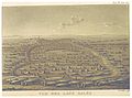 The Salinas (c. 1820)
 -
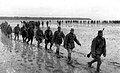 Soviet soldiers crossing the Syvash in late 1943
 -
 Illustration of the shallowness of water in the Syvash
 -
 Syvash waters turned reddish by Dunaliella salina microalgae
 -
 View of Lake Lemuria, one of the bodies of water tinted by algae

_p3.162_VUE_DES_LACS_SALES.jpg)


References
[edit]- ^ "Central Syvash". Ramsar Sites Information Service. Archived from the original on 6 September 2015. Retrieved 25 April 2018.
- ^ "Eastern Syvash". Ramsar Sites Information Service. Archived from the original on 9 December 2015. Retrieved 25 April 2018.
- ^ Baynes, T. S., ed. (1878). . Encyclopædia Britannica. Vol. 3 (9th ed.). New York: Charles Scribner's Sons. p. 169.
- ^ Paolucci, Daniela (2024-09-04). "Sapevi che esiste un lago completamente rosa? È una meraviglia della natura imperdibile". TTi Viaggi (in Italian). Retrieved 2025-04-17.
- ^ Siwaschsee. 3 September 2020. Archived from the original on 25 September 2014. Retrieved 10 May 2014.
- ^ a b c V. Siokhin; I. Chernichko; V. Kostyushyn; N. Krylov; Yu. Andrushchenko; T. Andrienko; Ya. Didukh; V. Kolomijchuk; L. Parkhisenko; R. Chernichko; T. Kirikova (2000). V. Siokhin; V. Kostyushyn (eds.). Sivash: the lagoon between two seas (PDF). ISBN 9058829960. Archived from the original (PDF) on 2014-05-12.
External links
[edit]![]() Media related to Syvash at Wikimedia Commons
Media related to Syvash at Wikimedia Commons