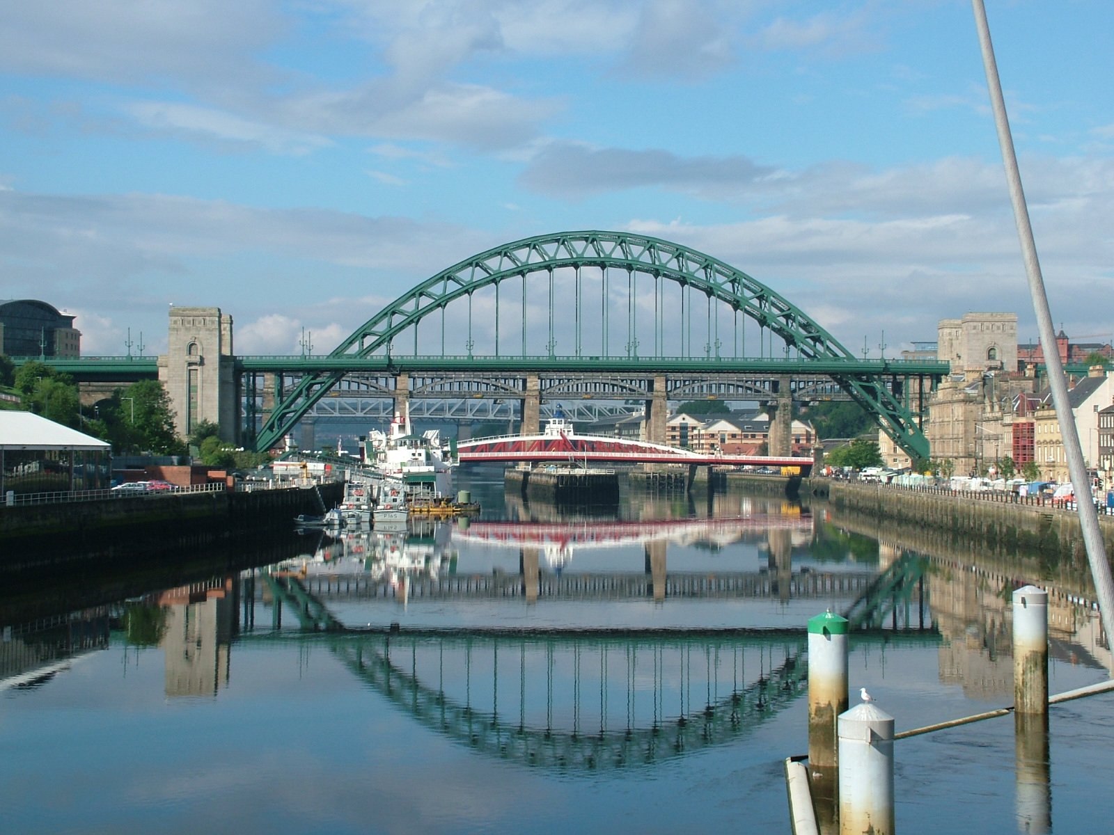
Tyneside
View on Wikipedia
Tyneside is a built-up area across the banks of the River Tyne in Northern England. The population of Tyneside as published in the 2011 census was 774,891. Tyneside is made up of the metropolitan boroughs of Newcastle upon Tyne, Gateshead, North Tyneside and South Tyneside. The area is surrounded by the North East Green Belt. Residents of the area are commonly referred to as Geordies.
Key Information


Settlements
[edit]
The ONS 2011 census had 774,891 census respondents inside the "Tyneside Built-up Area" or "Tyneside Urban Area".[1] These figures are a decline from 879,996;[2] this loss was mainly due to the ONS reclassifying Hetton-le-Hole, Houghton-le-Spring, Chester-le-Street and Washington in the Wearside Built-up Area instead of Tyneside. In both the 2001 and 2011 census the area was given the following subdivisions; Gateshead, Jarrow and Tynemouth had boundary changes:

| Subdivision | Population (2011) |
Population (2001) |
|---|---|---|
| Newcastle | 292,200 | 259,573 |
| Gateshead | 120,046 | 78,403 |
| South Shields | 75,337 | 82,854 |
| Tynemouth | 67,519 | 17,056 |
| Wallsend | 43,826 | 42,843 |
| Jarrow | 43,431 | 27,525 |
Transport
[edit]Geordies
[edit]The people of Newcastle, called "Geordies", have a reputation for their distinctive dialect and accent. Newcastle may have been given this name, a local diminutive of the name "George", because their miners used George Stephenson's safety lamp (invented in 1815 and called a "Georgie lamp") to prevent firedamp explosions, rather than the Davy lamp used elsewhere. An alternative explanation relates that during the Jacobite risings of 1715 and 1745 the people of Newcastle declared their allegiance to the Hanoverian Kings of Great Britain, George I and George II; whereas the rest of the county of Northumberland, to the north, stood loyal to James Francis Edward Stuart.
Coal production
[edit]While Newcastle upon Tyne had been an important local centre since Roman times, and was a major local market town from the Middle Ages, the development of Newcastle and Tyneside is owed to coal mining. Coal was first known to be dug in Tyneside from superficial seams in around 1200, but there is some evidence from Bede's writings that it may have been dug as early as 800 AD. Coal was dug from local drift mines and bell pits, and although initially only used locally, it was exported from the port of Newcastle from the mid 14th century onwards. Tyneside had a strategic advantage as far as the coal trade was concerned, because collier brigs could be loaded with coal on the Tyne and could sail down the east coast to London. In fact, the burgesses of Newcastle formed a cartel, and were known as the Hostmen. The Hostmen were able gain a monopoly over all of the coal exported from Tyneside, a monopoly which lasted a considerable time. A well-known group of workers on the river were the keelmen who handled the keels, boats that carried the coal from the riverbanks to the waiting colliers.[3]
Steel and shipbuilding
[edit]
The Derwent (valley), a major tributary of the Tyne that rises in County Durham, saw the development of the steel industry from around 1600 onwards. This was led by German immigrant cutlers and sword-makers, probably from around Solingen, who fled from religious persecution at home and settled in the then village of Shotley Bridge, near Consett.
The combination of coal and steel industries in the area was the catalyst for further major industrial development in the 19th century, including the shipbuilding industry; at its peak, the Tyneside shipyards were one of the largest centres of shipbuilding in the world and built an entire navy for Japan in the first decade of the 20th century. There is still a working shipyard in Wallsend.
Professional competitive rowing on the Tyne
[edit]From early in the 19th century, it was a custom to hold boat races on the Tyne. The Tyne had a large number of keelmen and wherrymen, who handled boats as part of their jobs. As on the River Thames, there were competitions to show who was the best oarsman. As a wherryman did not earn very much, competitive rowing was seen as a quick way of earning extra money. Regattas were held, and provided modest prizes for professionals, but the big money was made in challenge races, in which scullers or boat crews would challenge each other to a race over a set distance for a side stake. The crews would usually have backers, who would put up the stake money, as they saw the chance of financial gain from the race. In the days before mass attendances at football matches, races on the river were enormously popular, with tens of thousands attending. Betting would go on both before and during a race, the odds changing as the fortunes of the contestants changed. Contestants who became champions of the Tyne would often challenge the corresponding champions of the River Thames, and the race would be arranged to take place on one of the two rivers.
Rivalry between the Tyne and the Thames was very keen, and rowers who upheld the honour of the Tyne became local heroes. Three such oarsmen, who came from humble backgrounds and became household names in the North East, were Harry Clasper, Robert Chambers and James Renforth. Clasper was a champion rower in fours, as well as an innovative boat designer and a successful rowing coach. Chambers and Renforth were oarsmen who excelled at sculling. Both held the World Sculling Championship at different times. The popularity of all three men was such that when they died, many thousands attended their funeral processions, and magnificent funeral monuments were provided by popular subscription in all three cases. At the end of the 19th century professional competitive rowing on the Tyne began a gradual decline and would die out entirely leaving the amateur version.[4]
Rapper dancing
[edit]Despite its rapid growth in the Industrial Revolution, Tyneside developed one peculiar local custom, the rapper sword dance, which later spread to neighbouring areas of Northumberland and County Durham.
Industrial decline and regeneration
[edit]During the 1970s and 1980s, there was major industrial decline in the traditional British heavy industries, and Tyneside was hit hard. High unemployment rates and the national [Thatcher] government's resolve to push through with economic transformation led to great social unrest with strikes and occasional rioting in depressed areas.
From the late 1980s onward, an improving national economy and local regeneration helped the area to recover, and although unemployment is still a problem compared with some other areas of Britain, expansion of new industries such as tourism, science and high-technology, has fuelled local development, especially in Newcastle upon Tyne and Gateshead.
Economy
[edit]This is a chart of trend of regional gross value added of Tyneside at current basic prices published by the Office for National Statistics with figures in millions of British pounds sterling.[5]
| Year | Regional gross value added[a] | Agriculture[b] | Industry[c] | Services[d] |
|---|---|---|---|---|
| 1995 | 7,688 | 9 | 2,244 | 5,435 |
| 2000 | 9,930 | 8 | 2,567 | 7,356 |
| 2003 | 11,895 | 9 | 2,865 | 9,021 |
References
[edit]- ^ "2011 Census - Built-up areas". ONS. Archived from the original on 21 September 2013. Retrieved 1 July 2013.
- ^ "UK Government Web Archive". Archived from the original on 22 October 2012. Retrieved 3 October 2013.
- ^ Finch, Roger (1973). Coals from Newcastle. The Lavenham Press. ISBN 0-900963-39-5.
- ^ Whitehead, Ian (2002). The Sporting Tyne. ISBN 0-901273-42-2.
- ^ Office for National Statistics. pp. 240–253 Archived 2007-12-01 at the Wayback Machine.
Tyneside
View on GrokipediaDefinition and Scope
Etymology and Historical Naming
The name Tyneside is a compound of the River Tyne and "side," referring to the land along its banks on both the northern and southern shores. The River Tyne's designation traces to the Brittonic (ancient Celtic) *Tīnā, derived from the Indo-European root *tei-/*ti- meaning "to flow" or "to melt," a linguistic element common in pre-Roman hydronyms across Britain denoting steady watercourses.[8] [9] Prior to the 19th century, no unified term like Tyneside existed for the region; it was instead denoted by its constituent locales, rooted in Roman, Anglo-Saxon, and Norse influences. The Romans knew the river possibly as Vedra on early maps, though identification remains uncertain, with principal settlements including the fort and bridge at Pons Aelius (modern Newcastle), named for Emperor Hadrian's gens Aelia circa AD 122.[9] [10] Anglo-Saxon naming shaped places like Gateshead, from "gātēs hēafod" ("goats' head," referencing a promontory), and the Shields (North and South), from Middle English "schele" for fishermen's temporary huts or shelters established by the 13th century.[11] [12] The term Tyneside coalesced during the Industrial Revolution, by the early 1800s, to describe the burgeoning coal-shipping and shipbuilding corridor from inland collieries to the Tyne's mouth, encompassing Newcastle, Gateshead, and the Shields.[13] This usage reflected economic integration across the river, distinct from broader Northumbrian or Wearside areas, and persisted into modern administrative nomenclature, with North Tyneside and South Tyneside boroughs formalized in 1974.[14]Modern Boundaries and Administrative Composition
Tyneside lacks formal administrative status as a single entity but is commonly understood as the conurbation formed by the metropolitan boroughs of Newcastle upon Tyne, Gateshead, North Tyneside, and South Tyneside within the ceremonial county of Tyne and Wear. These boroughs, established under the Local Government Act 1972 and operative from 1 April 1974, provide unitary local government services following the dissolution of the Tyne and Wear Metropolitan County Council in 1986.[15][16] The modern boundaries approximate the continuous urban fabric along the River Tyne, extending from the North Sea coast near Whitley Bay and South Shields southward and westward to include contiguous settlements such as Gosforth, Jesmond, and Blaydon, as reflected in the Office for National Statistics' delineation of built-up areas based on Ordnance Survey data identifying developed land with populations exceeding 10,000.[17] This configuration excludes the Sunderland area, associated with Wearside, emphasizing Tyneside's focus on the Tyne estuary and lower valley. Administrative oversight occurs through individual borough councils, coordinated regionally via the North East Mayoral Combined Authority for strategic functions like transport and economic development since its establishment in 2024.[18][19]| Metropolitan Borough | Population (2021 Census) | Area (km²) |
|---|---|---|
| Newcastle upon Tyne | 301,800 | 113 |
| Gateshead | 196,100 | 142 |
| North Tyneside | 200,100 | 84 |
| South Tyneside | 150,200 | 64 |
Geography and Environment
Physical Landscape and River Tyne
The River Tyne forms the central artery of Tyneside's physical landscape, stretching 118 kilometres from its source at the confluence of the North Tyne and South Tyne near Hexham to its mouth at Tynemouth on the North Sea.[22][9] In the Tyneside region, the lower Tyne occupies a broad alluvial valley with terraces up to 1 kilometre wide, flanked by incised channels that have shaped urban development along both banks.[23] Geologically, Tyneside's terrain underlies Carboniferous sedimentary rocks, including coal measures, sandstones, and limestones, overlain in places by Permian magnesian limestone formations, particularly along the eastern coastal cliffs near South Shields.[24][23] These strata, part of the Durham Coalfield, feature faulted and folded structures that influence the river's meandering path and the presence of sandstone hills rising as isolated features amid glacial drift deposits.[24] Topographically, the area exhibits a mix of flat valley floors and undulating higher ground, with elevations reaching 384 metres in the southwestern extents before descending into the Tyne Gorge—a narrow, steep-sided section between Newcastle upon Tyne and Gateshead where the river cuts through resistant sandstones, creating dramatic cliffs and promoting dense urban clustering.[23] Glacial legacies from the last ice age, including U-shaped valleys and till-covered plateaus, further define the landscape, with post-glacial river incision exposing bedrock and forming the current wandering gravel-bed channel in downstream reaches.[25][26] This configuration has historically facilitated transport and industry while constraining floodplain expansion through natural levees and terraces.[23]Climate and Environmental Challenges
Tyneside experiences a temperate oceanic climate characterized by mild temperatures, high rainfall, and frequent wind. Average annual precipitation in Newcastle upon Tyne exceeds 600 mm, with wettest months in late autumn and winter, often exceeding 60 mm monthly. Summer highs typically reach 19°C in July, while winter lows average around 2°C in January, moderated by proximity to the North Sea and the Gulf Stream influence.[27][28] The region sees about 1,500 hours of sunshine annually, though overcast skies prevail, contributing to relatively low evaporation rates and persistent damp conditions.[29] Historically, Tyneside's industrial activities, including coal mining, steel production, and shipbuilding, generated severe environmental degradation, with heavy metal contamination and acidic runoff polluting the River Tyne and its tributaries. Abandoned metal mines continue to affect 217 km of rivers in the Tyne catchment, releasing harmful metals that impair water quality and aquatic ecosystems. Remediation efforts since the late 20th century, including treatment schemes, have improved conditions, but legacy pollutants persist in sediments.[30] Contemporary challenges include urban air pollution from traffic emissions, particularly nitrogen dioxide (NO2) and particulate matter, with hotspots along major roads like Hadrian Road in South Tyneside recording annual NO2 levels up to 27.3 µg/m³. The River Tyne faces ongoing sewage discharges, with over 3,000 combined sewer overflow spills in 2023, exacerbating nutrient pollution despite overall ecological classifications of moderate to good. Flooding poses a recurrent risk, driven by surface water runoff in densely built areas and intensified by climate change-induced heavier rainfall; events in 2015-2016 affected thousands of properties, prompting resilience schemes funded at £6.9 million for coastal defenses in South Tyneside. Local authorities monitor and mitigate these through strategies targeting traffic reduction and infrastructure upgrades, though projections indicate heightened vulnerability to storms and erosion without adaptation.[31][32][33][34][35][36]Demographics and Society
Population Trends and Urban Density
The population of Tyneside expanded dramatically during the Industrial Revolution, fueled by demand for labor in coal mining, shipbuilding, and engineering. In 1801, Newcastle upon Tyne had a population of 37,248, which surged to 215,000 by 1901 as the conurbation attracted migrants from rural areas and Ireland.[37] [38] Gateshead's population more than quadrupled over the same period, exceeding 100,000 by 1901, reflecting the broader regional boom along the Tyne. Growth persisted into the early 20th century, reaching a peak around the 1951 census amid wartime and post-war industrial activity, with the core urban area estimated at over 800,000. Deindustrialization from the 1960s onward, marked by closures in heavy industry due to global competition and resource exhaustion, triggered population decline through out-migration and reduced birth rates. [39] Newcastle's population fell from 291,723 in 1951 to 222,700 by 1991, while the wider Tyneside area contracted similarly until the 1990s.[37] Recent decades have seen stabilization and modest recovery, supported by economic diversification, university expansion attracting students, and limited net migration. Between 2011 and 2021, constituent boroughs recorded net gains: Newcastle upon Tyne increased by 19,900 to approximately 300,000, North Tyneside by 8,200 to 209,000, and Gateshead and South Tyneside showed smaller upticks, yielding a built-up area total nearing 850,000 by 2021.[40] [41] Tyneside's urban density remains elevated compared to national averages, underscoring its compact conurbation form. Tyne and Wear, encompassing Tyneside, averaged 2,115 persons per square kilometer in recent estimates, well above England's 434 per square kilometer in 2021.[42] [41] Core areas like Newcastle upon Tyne exhibit densities around 2,400 per square kilometer, with higher concentrations in inner-city wards driven by terraced housing from the industrial era and modern high-rise developments.[43] This density facilitates efficient public transport but contributes to pressures on infrastructure and housing affordability.Ethnic and Cultural Composition
In the 2021 United Kingdom census, the ethnic composition of Tyneside, encompassing the metropolitan boroughs of Newcastle upon Tyne, Gateshead, North Tyneside, and South Tyneside, remained predominantly White, reflecting historical patterns of settlement dominated by native British populations and earlier waves of intra-UK migration from Ireland and Scotland during the Industrial Revolution. Across these areas, approximately 90% of residents identified as White, with the category primarily comprising those self-identifying as English, Welsh, Scottish, Northern Irish, or British. [40] [44] [20] [45] Newcastle upon Tyne exhibited the highest relative diversity, with 80.0% identifying as White (a decline from 85.5% in 2011), driven by its role as a university city attracting international students and recent migrants, while the other boroughs ranged from 93.5% to 94.9% White. [40] [44] [20] [45] Non-White ethnic groups constituted a small but growing minority, totaling around 10% region-wide, with Asian or Asian British forming the largest subgroup at roughly 3-11% depending on the borough—predominantly Chinese, Indian, and Pakistani origins in Newcastle, linked to post-1940s Commonwealth labor migration and subsequent family reunification. [40] Black, Black British, Caribbean, or African groups accounted for 1-3%, often tied to more recent African and Caribbean arrivals, while Mixed and Other ethnic categories each hovered below 2%. [44] [20] Historical immigration, including 19th-century Irish inflows during coal and shipbuilding booms (estimated at over 20,000 by 1851 in the broader Tyne area), has largely assimilated into the White British category, contributing to cultural rather than visibly distinct ethnic persistence. [46] Post-war Yemeni and Chinese communities in port-related trades added early diversity, but overall levels remain below the England and Wales average of 81.7% White, underscoring Tyneside's relative ethnic homogeneity compared to southern urban centers. [47] Culturally, Tyneside's composition centers on a robust regional identity known as Geordie, characterized by a distinct Northumbrian dialect derived from Old English and Norse influences, reinforced by centuries of industrial working-class solidarity in mining, shipbuilding, and engineering. [48] Traditions such as the rapper sword dance—originating in 19th-century pit villages as a miners' performance art combining acrobatics and steel tools—exemplify this heritage, evolving from practical work rhythms into a preserved folk custom performed at events like the North East England folk festivals. Folk music and songs, often chronicling labor struggles and keelmen (flat-bottomed coal boat operators) life along the Tyne, form a core element, with ballads like "The Keel Row" transmitted orally since the 18th century and revived in post-1950s folk movements. [49] Irish cultural imprints persist through societies like the Tyneside Irish Cultural Society, hosting ceili dances and music sessions that blend with local pub traditions, though without significant ethnic segregation. [50] Football rivalries, particularly between Newcastle United and Sunderland, underpin communal bonds, while contemporary cultural expressions incorporate limited multicultural elements, such as Chinese New Year events in Newcastle's small Chinatown, reflecting modest integration rather than transformative diversity. [51]| Borough | White (%) | Asian/Asian British (%) | Black/Black British (%) | Other Non-White (%) |
|---|---|---|---|---|
| Newcastle upon Tyne | 80.0 | 11.4 | 3.3 | 5.3 |
| Gateshead | 93.5 | 2.5 | 1.1 | 2.9 |
| North Tyneside | 94.9 | ~1.4 | ~0.5 | ~3.2 |
| South Tyneside | 94.4 | ~1.4 | ~0.5 | ~3.7 |