Hubbry Logo
Western disturbanceWestern disturbanceMain
Open search
Western disturbance
Community hub
Western disturbance
logo
8 pages, 0 posts
0 subscribers
Be the first to start a discussion here.
Western disturbance
Western disturbance
from Wikipedia
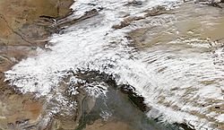
A Western Disturbance over Northern India and Pakistan in November 2012

A western disturbance is an extratropical storm originating in the Mediterranean region that brings sudden winter rain to the northwestern parts of the Indian subcontinent,[1][2] which extends as east as up to northern parts of Bangladesh and South eastern Nepal.[3] It is a non-monsoonal precipitation pattern driven by the westerlies. The moisture in these storms usually originates over the Mediterranean Sea, the Caspian Sea and the Black Sea.[4][5] Extratropical storms are a global phenomena with moisture usually carried in the upper atmosphere, unlike their tropical counterparts where the moisture is carried in the lower atmosphere. In the case of the Indian subcontinent, moisture is sometimes shed as rain when the storm system encounters the Himalayas. Western disturbances are more frequent and stronger in the winter season.[6]

Western disturbances are important for the development of the Rabi crop, which includes the locally important staple wheat.[7][8]

Formation

[edit]

Western disturbances originate in the Mediterranean region in Mediterranean sea. A high-pressure area over Ukraine and neighbourhood consolidates, causing the intrusion of cold air from polar regions towards an area of relatively warmer air with high moisture. This generates favorable conditions for cyclogenesis in the upper atmosphere, which promotes the formation of an eastward-moving extratropical depression. Traveling at speeds up to 12 m/s (43 km/h; 27 mph), the disturbance moves towards the Indian subcontinent until the Himalayas inhibits its development, upon which the depression rapidly weakens.[5] The western disturbances are embedded in the mid-latitude subtropical westerly jet stream.[9]

A western disturbance moving east towards the Indian subcontinent. It can be seen as a cloud patch originating from the Black Sea, progressing east thereafter.

Significance and impact

[edit]
A strong western disturbance affecting the northern parts of the Indian subcontinent in February 2013. Such disturbances bring substantial amount of rainfall and are a threat to lives and property.

Western disturbances, specifically the ones in winter, bring moderate to heavy rain in low-lying areas and heavy snow to mountainous areas of the Indian Subcontinent. They are the cause of most winter and post-monsoon season rainfall across Pakistan and northwest India. Precipitation during the winter season has great importance in agriculture, particularly for the rabi crops.[7] Wheat among them is one of the most important crops, which helps to meet India's food security. An average of four to five western disturbances form during the winter season. The rainfall distribution and amount varies with every western disturbance.

Western disturbances are usually associated with cloudy sky, higher night temperatures and unusual rain. Excessive precipitation due to western disturbances can cause crop damage, landslides, floods and avalanches. Over the Indo-Gangetic plains, they occasionally bring cold wave conditions and dense fog.[5] These conditions remain stable until disturbed by another western disturbance. When western disturbances move across northwest India before the onset of monsoon, a temporary advancement of monsoon current appears over the region.

The strongest western disturbances usually occur in the western and northern parts of Pakistan, where flooding is reported number of times during the winter season.

Effects on monsoon

[edit]

Western disturbances start declining in numbers after winter. During the summer months of April and May, they move across north India. The southwest monsoon current generally progresses from east to west in the northern Himalayan region, unlike western disturbances which follow a west to east trend in north India with consequent rise in pressure carrying cold pool of air. This helps in the activation of monsoon in Afghanistan and certain parts of northwest India. It also causes pre-monsoon rainfall especially in northern India.[citation needed]

The interaction of the monsoon trough with western disturbances may occasionally cause dense clouding and heavy precipitation. The 2013 North India floods, which killed more than 5000 people in a span of 3 days, is said to be a result of one such interaction.[5]

See also

[edit]

References

[edit]
[edit]
Revisions and contributorsEdit on WikipediaRead on Wikipedia
from Grokipedia
A Western disturbance is an extratropical cyclonic storm originating in the Mediterranean region or area, embedded within the subtropical westerly , that travels eastward to bring non-monsoonal —primarily in the northwestern Indian plains and snowfall in the Himalayan —during the winter and pre-monsoon seasons ( to May). These disturbances form through baroclinic , where upper-level troughs in the interact with lower-level moisture-laden air, often intensifying over land due to orographic lifting when encountering the Himalayan terrain. Typically numbering 4–6 intense events per winter , they contribute approximately one-third of the annual in northern , sustaining agriculture, replenishing river systems like the Indus (15–44% of runoff) and (6–20%), and forming essential for in the region. However, Western disturbances can trigger phenomena, including cold waves, , avalanches, landslides, and flash floods, as seen in the catastrophic 2013 deluge that claimed over 6,000 lives. Analyses show mixed trends in the frequency of these events, with some indicating an increase of up to 20% per century in winter over the western and central and a lengthening , linked to change-driven strengthening and delayed northward migration of the subtropical jet, while other recent reviews note regional variability and no clear overall trend, heightening risks of extreme and interactions with the , as evidenced by the 2025 anomaly with 14 disturbances causing intensified flash floods and landslides in the . Despite their benefits for rainfed agriculture in states like (where over 80% of farmland depends on such rains), declining intensity in some areas has led to reduced snowfall and prolonged dry spells, exacerbating and impacting fruit production.

Overview

Definition

A Western disturbance is defined as an extratropical storm or low-pressure system that originates in mid-latitude regions, particularly over the , , or . These systems manifest as synoptic-scale weather phenomena embedded within the subtropical westerly jet stream (SWJ), typically appearing as eastward-propagating upper-level troughs or baroclinic lows with a vorticity maximum around 350 hPa. Classified as non-tropical weather systems, Western disturbances are distinct from tropical cyclones due to their development in mid-latitudes and association with westerly winds rather than easterly or equatorial convergence. They often link to surface low-pressure areas or cyclonic circulations in the mid- and lower , propagating eastward across regions like the toward the . No formal scheme exists, but they are categorized informally by intensity, such as weak troughs or stronger "western depressions" with multiple closed isobars. As synoptic-scale events, Western disturbances span thousands of kilometers, influencing large atmospheric regions through their interaction with the SWJ. In the context of , they contribute to patterns in northwest and by transporting moisture eastward.

Seasonal Patterns

Western disturbances exhibit distinct seasonal patterns, with their frequency peaking during the winter months from to across northern . During this period, an average of 6–7 events occur per month, primarily influencing the northwestern regions and contributing significantly to seasonal in the form of . This heightened activity is closely associated with the subtropical westerly , which facilitates their eastward . In contrast, the frequency diminishes notably in the pre-monsoon season ( to June) and post-monsoon period (September to October), where occurrences are sporadic and typically limited to 1–2 events per month or fewer, reflecting weaker synoptic forcing during these transitional phases. The intensity of western disturbances also varies markedly by season, with winter events generally stronger due to the involvement of colder air masses from extratropical latitudes, which enhance moisture convergence and over the , resulting in higher amounts. For instance, the strongest disturbances—those in the top intensity pentile—are approximately 50 times more prevalent in January compared to August, often leading to heavy snowfall in elevated areas and rainfall in the plains. Summer and transitional season disturbances, by comparison, tend to be weaker, with reduced baroclinicity and less pronounced thermal contrasts, yielding lighter that rarely extends beyond localized effects. These intensity differences underscore the disturbances' role in modulating winter hydroclimatology while having minimal influence during warmer months. Regionally, western disturbances are most pronounced in northwest , particularly affecting states such as , , and & , where they deliver the bulk of non-monsoonal precipitation and influence local weather variability north of 20°N latitude. Their impacts taper off toward the southern extents, with diminishing frequency and intensity over central and eastern , as the systems weaken upon interaction with varying and atmospheric conditions en route. This northwesterly bias highlights the disturbances' critical hydrological importance for the Indo-Gangetic plains and Himalayan during the dry winter .

Meteorology

Origin and Formation

Western disturbances originate primarily over the , with additional sources in the Black Sea and regions, where they manifest as cyclonic circulations or troughs in the mid- and lower tropospheric levels. These systems develop through the interaction of polar cold, dry air masses with subtropical warm air masses, creating frontal boundaries that enhance atmospheric baroclinicity in the mid-latitudes. Although initial formation involves these interactions, the primary moisture for subsequent is sourced from the during eastward propagation. This interaction sets the stage for the development of extratropical systems, with the Mediterranean contributing approximately 33% of all western disturbances tracked in observational data. The core formation process is driven by baroclinic instability, a fundamental mechanism in mid-latitude where horizontal temperature gradients between air masses release potential energy, leading to . Small-scale perturbations in the atmosphere grow into organized troughs due to this instability, often downstream of topographic features like the , initiating the cyclonic development west of major ranges such as the Hindu Kush. These disturbances exhibit properties akin to immature extratropical cyclones, characterized by a northwestward tilt with height and supported by maxima in the upper . The subtropical westerly (SWJ) plays a pivotal role in steering and intensifying these systems eastward, embedding them within its core flow, which typically positions over the southern during winter. Development progresses through distinct stages: initial upper-level trough formation linked to instabilities or extratropical cutoffs; subsequent deepening via baroclinic energy release and moist processes; and embedding in regions of upper-level divergence around 250 hPa, which promotes vertical motion and system maturation. This progression results in coherent synoptic-scale lows that propagate at speeds of 6–12 m/s along the jet axis.

Structure and Dynamics

Western disturbances are synoptic-scale extratropical cyclones with a typical of 1000–2000 km and a lifecycle duration of 3–7 days. Their structure comprises an upper-level trough embedded within the subtropical westerly at approximately 200 hPa, coupled with a lower-level cyclonic circulation that develops into surface depressions. These systems often originate from mid-latitude seas as weak perturbations that intensify through baroclinic processes. In the vertical cross-section, western disturbances exhibit a classic frontal organization, with a leading the system—ad vecting moist air from southern latitudes—and a trailing introducing dry air from the north. This is marked by a warm of about 2 at upper levels (200 hPa) overlying a cold anomaly of roughly 3 at (500 hPa), while the lower features a cold, moist core. Associated bands extend from high-level cirrus clouds in the northern sector, approximately 600 km from the center, to mid- and low-level clouds in the central and western areas. Precipitating types predominantly include nimbostratus and stratus/stratocumulus, facilitating widespread snowfall and rainfall. The dynamics of these disturbances are governed by maxima, which peak at around 325 hPa and drive intensification through enhanced . Frontogenesis arises from sharp temperature gradients and deformation fields induced by the , producing a northwestward tilt with height that underscores their baroclinic nature. mechanisms are closely tied to conditional symmetric (CSI), which promotes intense vertical ascent ahead of the system in the mid-troposphere (near 450 hPa), often amplified by moisture convergence. Prominent associated features include surface low-pressure centers, typically forming as depressions about 500 km east of the disturbance core with anomalies of approximately 1 hPa. Upper-level troughs provide the backbone for the system's propagation, while patterns of equivalent potential temperature (θ_e) advection reveal an eastward moisture tilt at lower levels and a northeastward tilt with height, sustaining the disturbance's thermal and moisture structure throughout its lifecycle.

Trajectory

Path and Movement

Western disturbances (WDs) originate primarily from the , , or regions and propagate eastward along the subtropical westerly jet (SWJ), traversing toward the . These systems are embedded within the dynamics, which facilitate their as synoptic-scale troughs. The typical progression occurs at speeds of 6–12 m/s, with a mean of approximately 8 m/s, allowing them to cover distances of 2000–3000 km from their source to the northwestern , though some extend up to thousands of kilometers farther into . The movement of WDs is steered predominantly by upper-level westerly winds within the SWJ, which guide their horizontal trajectory across vast expanses of flat and arid terrains. Occasional southward dips occur as the systems interact with the jet's variability, enabling extensions into lower latitudes of the , often influenced by factors such as upper-tropospheric temperature gradients and teleconnections like the North Atlantic Oscillation. This steering mechanism ensures a consistent eastward flow, typically spanning 3000–5000 km from Mediterranean origins to northwest . Path variations among WDs are notable, with northern routes often remaining above 36–37°N latitude and primarily affecting and regions north of the , while southern routes dip as low as 20°N, impacting and passing via the . These divergences depend on the latitudinal position of the SWJ, resulting in a bimodal distribution of trajectories centered around a mean of 35°N. Such variations highlight the dynamic nature of WD propagation, with northern paths covering more northerly terrains across and southern ones veering toward subtropical influences.

Interaction with Topography

As Western disturbances (WDs) traverse eastward from their origins in the Mediterranean or regions, they encounter the formidable topography of the Hindu Kush and Himalayan ranges, which profoundly modifies their structure and intensity through orographic processes. The ascent of moist air masses over these elevated terrains triggers , forcing air parcels upward and leading to adiabatic cooling and , thereby enhancing , particularly in the form of snowfall during winter months. This interaction is most pronounced over the , where WDs contribute 55%–90% of annual winter , with maximum and updrafts occurring approximately one day before the system's center crosses the orography. Orographic forcing intensifies WDs by mechanically uplifting southerly moist flows from the , resulting in rates that can be 20–30% higher over windward slopes compared to surrounding areas. The Hindu Kush and also induce blocking effects, slowing the eastward progression of WDs and prolonging their influence over the region. High mountain barriers, such as the in Jammu and Kashmir, act as obstacles that deflect or stall these systems, enhancing downstream divergence and thereby amplifying precipitation intensity downstream while creating stationary low-pressure patterns. For instance, during the January 21–23, 1999, event over the , blocking by the led to prolonged heavy snowfall, with the range's elevation (up to 4,500 m) causing orographic convergence and sustained cyclonic activity in the lee, resulting in accumulated precipitation gradients exceeding fivefold between valleys and ridges. This blocking is exacerbated by the Pamir-Hindu Kush bifurcation around 36–37° N, which sensitively routes WDs toward the or depending on the subtropical westerly jet's position. On the leeward side of the , WDs experience rapid dissipation due to downslope flow and reduced moisture availability, contributing to a pronounced effect in the southern Indo-Gangetic plains. This lee-side drying results in significantly lower —often less than 10% of windward amounts—while fostering conditions for intensification within intermontane valleys, where channeled flows and convergence can spawn secondary . In the , for example, stronger meridional winds and higher specific humidity trapped by surrounding topography, including the Pir Panjal, lead to localized cyclone development and enhanced orographic rainfall during WD passages. Terrain-induced further complicates these interactions, generating mesoscale features such as secondary lows through orographic convergence and shear on windward slopes. As WDs approach the , the interaction amplifies upper-tropospheric cyclonic (peaking around 350 hPa), with diabatic heating from reinforcing mesoscale convective systems 200–1,200 km east of the WD center. High-resolution modeling confirms that these terrain-forced maxima drive the formation of embedded lows, particularly in valleys like those in Jammu and Kashmir, where Pir Panjal blocking sustains prolonged mesoscale activity and heavy localized precipitation.

Impacts

Hydrological and Agricultural Effects

Western disturbances provide the majority of winter in northwest , accounting for more than 80% of rainfall and snowfall during the season in regions such as Jammu and Kashmir, , , and . This contributes approximately 30% of the annual total in these areas, playing a vital role in recharging and replenishing reservoirs that support and in arid winter months. In particular, the rainfall aids in maintaining water levels in key reservoirs across and , ensuring sustained availability for agricultural and domestic use. The snowfall induced by these disturbances in the is crucial for the hydrological cycle, as it accumulates in higher elevations and provides meltwater to perennial rivers like the Indus and . This contributes significantly to river flows, particularly during the dry pre-monsoon period, supporting downstream ecosystems and water resources across northern and . Agriculturally, western disturbances deliver timely moisture essential for the growth of Rabi crops, including and , which are sown in the winter months when natural rainfall is otherwise scarce. This precipitation enhances soil moisture, reduces the need for supplemental , and boosts crop yields in the Indo-Gangetic plains. The disturbances are essential for Rabi crops in key wheat-producing states like , , and , which together account for a majority of India's wheat production (over 60%), with the crop's annual economic value exceeding $30 billion as of 2023.

Weather and Societal Hazards

Western disturbances often trigger cold waves across the Indo-Gangetic Plains, where temperatures can drop significantly below seasonal norms, leading to severe cold conditions that persist for several days. These events are exacerbated by the southward intrusion of cold air masses following the passage of the disturbance, resulting in and chilling winds that affect densely populated urban and rural areas. Associated dense , particularly during winter months, reduces visibility to less than 50 meters in extreme cases, disrupting daily life and increasing risks of accidents. Health impacts include heightened to respiratory illnesses and , especially among the elderly, children, and homeless populations, with cold exposure contributing to hundreds of deaths annually in northern . In the Himalayan region, intense Western disturbances deposit heavy snowfall, which can destabilize slopes and trigger and landslides, posing lethal threats to mountaineers, local communities, and . , often occurring at elevations above 3,000 meters, bury roads and settlements under meters of snow, while landslides from saturated soils block vital passes like the Rohtang and . Rapid melting of accumulated snow in subsequent warmer periods can lead to flash floods in river valleys, amplifying downstream hazards through sudden water surges. Topographic interactions enhance precipitation intensity over these mountains, intensifying such risks. Notable extreme events underscore these hazards; for instance, a stalled Western disturbance in June 2013 interacted with systems, contributing to unprecedented rainfall that triggered landslides and floods in , resulting in over 6,000 deaths and widespread devastation. Similarly, the intense in early 2022, driven by multiple Western disturbances, led to approximately 720 deaths from cold exposure across northern , with and reporting the highest tolls. More recently, in August 2025, a lingering Western disturbance contributed to extreme rainfall in the Himalayan region during the , exacerbating flood risks. Societally, these disturbances cause significant disruptions, including road and rail blockages from and , flight cancellations at major airports like and , and occasional power outages due to damaged lines in snowy terrains. Economic losses arise from halted commerce, tourism declines in hill stations, and crop damage during extreme episodes, with isolated incidents costing millions in relief and recovery efforts.

Broader Context

Relation to Indian Monsoon

Western disturbances during the pre-monsoon period (–May) contribute to the onset of the summer by transporting moisture into the lower over northwest , thereby enhancing atmospheric humidity and convective instability. This moistening effect, sourced from the Mediterranean and Atlantic s, preconditions the atmosphere for the advance of the , often leading to an earlier arrival in the . Observations indicate that increased frequency of these pre-monsoon systems correlates with accelerated progression, as documented in analyses of historical weather reports spanning several decades. In contrast, intense winter or persisting late-season western disturbances can suppress monsoon advancement through equatorward shifts in the subtropical , which introduce dry mid-latitude air masses over the . This alteration disrupts the typical circulation by strengthening and weakening the , thereby delaying rainfall onset and reducing overall intensity. Such suppression mechanisms have been identified as key factors in historical large-scale deficits. Dynamically, western disturbances interact with the tropical easterlies of the system, fostering hybrid cyclonic formations or extended break periods in rainfall. These interactions often involve baroclinic instabilities and eddy momentum fluxes that enable vortex mergers between extratropical disturbances and depressions, resulting in enhanced or circulation disruptions. Moisture exchange during these events can relocate heavy rainfall patterns, with jet streak excitations from disturbances amplifying tropical cyclone intensity. The 2009 Indian summer monsoon failure exemplifies the role of anomalous western disturbance activity, where deepened equatorward penetration of upper-tropospheric induced widespread dry conditions and across the country. This led to a severe rainfall deficit of approximately 23% below the long-period average, exacerbating and agricultural impacts, partly due to the sustained influence of mid-latitude troughs on dynamics.

Variability and Climate Influences

Western disturbances have exhibited notable variability over recent decades, with observational data showing mixed trends and no clear long-term change in frequency over the western Himalaya from 1950 to 2022. Recent analyses indicate significant increases in winter frequency (~20% per century) over the western and central Himalaya and , attributed to strengthening of the subtropical westerly jet, as well as rises in pre-monsoon (April–June) and early (July) events across the western Himalaya, , and , linked to delayed northward migration of the jet. The WD season has lengthened, with events in May rising from ~10 per month pre-2000 to ~14 per month recently, and doubling in June over the last 20 years. Regional variations include declines in some areas, such as parts of the western Himalaya, and increasing intensity of associated precipitation events in the , where extreme events have intensified (up to 3.5 mm day⁻¹ per decade from 1979–2020), contributing to more severe hydrological impacts. Climate change is influencing WD variability through multiple mechanisms, including Arctic amplification—rapid warming in polar regions—which alters the subtropical jet stream's paths and strength; recent strengthening has contributed to increased winter WD frequency, while delayed northward migration extends the season with more events in late winter and pre-monsoon periods. Warming in the alters moisture supply and storm tracks for these systems. These changes shift WD activity toward pre- and post-winter periods in some projections, exacerbating seasonal imbalances in . Modeling Western disturbances poses significant challenges in global climate models (GCMs), which often underrepresent their frequency and intensity due to coarse resolution that fails to capture the synoptic-scale dynamics of the subtropical westerly jet and orographic interactions. CMIP5 simulations, for instance, exhibit biases in WD tracks and contributions, with many models simulating only 50-70% of observed WD events over northern . High-resolution regional models, such as those nested within GCM outputs at 10-20 km scales, are essential to better resolve these features, improving simulations of WD-induced snowfall and rainfall in topographically complex areas like the . A 2025 emphasizes ongoing uncertainties in CMIP6 representations and the need for refined regional modeling. Future projections under high-emission scenarios (e.g., RCP8.5) suggest a potential decline in WD frequency by 11-17% by 2100, with intensity reductions of ~12%, potentially leading to a 20-30% reduction in winter precipitation over the and Indo-Gangetic plains, severely impacting for and . These estimates align with IPCC assessments on trends and highlight uncertainties in moisture transport from the Mediterranean, underscoring the need for refined regional modeling to inform strategies. Variability in these projections is influenced by interactions with the Indian monsoon, where altered WD timing could modulate early-season rainfall patterns.

References

Add your contribution
Related Hubs
User Avatar
No comments yet.