

Community hub
Recent from talks
Contribute something
Nothing was collected or created yet.
Zaltbommel
View on WikipediaZaltbommel (Dutch pronunciation: [zɑldˈbɔməl] ⓘ), also known, historically and colloquially, as Bommel, is a municipality and a city in the Netherlands.
Key Information


History
[edit]The city of Zaltbommel
[edit]The town of Zaltbommel was first mentioned as "Bomela" in the year 850. Zaltbommel received city rights in 1231 and these were renewed in 1316. In 1599 during the Eighty Years War, Zaltbommel was besieged by Spanish forces but was relieved by an Anglo-Dutch force led by Maurice of Orange. The bridge over the Waal at Zaltbommel (which has since been replaced) features in a celebrated twentieth-century Dutch sonnet, De moeder de vrouw, by Martinus Nijhoff.[5]
Zaltbommel was expanded to its current size on 1 January 1999, by a merger of the municipalities of Brakel, Kerkwijk and Zaltbommel. The municipality is situated in the heart of the Netherlands, close to the A2 Motorway, the railway line from Utrecht to 's‑Hertogenbosch and the rivers Waal and Maas.
Topography
[edit]
Dutch Topographic map of Zaltbommel (municipality), Sept. 2014
Population centres
[edit]The municipality, consists of 13 population centres and had a population of 29,447 in 2021.
| Name | Population (1-1-2015) |
Population (1-1-2016) |
|---|---|---|
| Aalst | 2102 | 2106 |
| Bern | 36 | 33 |
| Brakel | 3050 | 3066 |
| Bruchem | 1674 | 1668 |
| Delwijnen | 341 | 337 |
| Gameren | 2433 | 2466 |
| Kerkwijk | 629 | 640 |
| Nederhemert | 1612 | 1604 |
| Nieuwaal | 732 | 758 |
| Poederoijen | 1013 | 1039 |
| Zaltbommel | 12040 | 12143 |
| Zuilichem | 1704 | 1702 |
| Total | 27366 | 27562 |
Notable residents
[edit]

- Maarten van Rossum (ca.1478–1555) military tactician and commander
- Elbertus Leoninus (1519 or 1520 – 1598) jurist and statesman, helped negotiate the Pacification of Ghent
- Marigje Arriens (ca.1520–1591) an alleged Dutch witch
- Caspar Barlaeus (1584–1648) polymath and Renaissance humanist, a theologian, poet, and historian
- Andreas Essenius (1618–1677) Dutch Reformed theologian, controversialist and academic
- Jacob Abraham de Mist (1749–1823) statesman, Head of State of the National Assembly of the Batavian Republic
- Lion Philips (1794–1866) tobacco merchant, grandfather of Gerard and Anton Philips
- Sophie Pressburg (1797–1854), grandmother of Anton and Gerard Philips
- Hendrik Antonie Lodewijk Hamelberg (1826–1896), consul general and special envoy of the Orange Free State
- Gerard Philips (1858–1942), industrialist, co-founder of Philips Electronics
- Anton Philips (1874–1951), industrialist, co-founder of Philips Electronics
- Johannes van Maaren (1890–1963) wrestler, competed at the 1920, 1924 and 1928 Summer Olympics
- Anouchka van Miltenburg (born 1967) retired politician
The arts
[edit]
- Lucas Vorsterman (1595–1675), Baroque engraver
- Warnard van Rijsen (1625–1670), a Dutch Golden Age painter.
- Johannes Vorstermans (ca.1643– ca.1699/1719) Dutch Golden Age landscape painter.
- Gerard Hoet (1648–1743) Dutch Golden Age painter
- Jan Soukens (c.1650–c.1725) a Dutch Golden Age painter
- Suzanne Leenhoff (1829–1906), pianist, married Édouard Manet at Zaltbommel in 1863[6]
- Anton van Anrooy (1870–1949), painter and illustrator
- Peter van Anrooy (1879–1954) composer and conductor of classical music
- Fiep Westendorp (1916-2004), illustrator
- Thorwald Jørgensen (born 1980) classical musician, specialises in the theremin
Image gallery
[edit]-
 Zaltbommel (in the upper right-hand corner of the image) is situated on the banks of the Waal. Major north–south highways and railways cross the river in the town, just east of the town centre.
 -
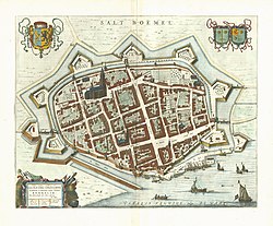 1649 map of Zaltbommel in Willem and Joan Blaeu's "Toonneel der Steden"
 -
 Tyel & Salt Boemel, 1649


References
[edit]- ^ "Burgemeester Van den Bosch" [Mayor Van den Bosch] (in Dutch). Gemeente Zaltbommel. Retrieved 24 July 2014.
- ^ "Kerncijfers wijken en buurten 2020" [Key figures for neighbourhoods 2020]. StatLine (in Dutch). CBS. 24 July 2020. Retrieved 19 September 2020.
- ^ "Postcodetool for 5301LB". Actueel Hoogtebestand Nederland (in Dutch). Het Waterschapshuis. Archived from the original on 7 January 2019. Retrieved 24 July 2014.
- ^ "Bevolkingsontwikkeling; regio per maand" [Population growth; regions per month]. CBS Statline (in Dutch). CBS. 1 January 2021. Retrieved 2 January 2022.
- ^ Hollandse Gedichten http://home.kpn.nl/grumbl/gedichten/Hollandse%20gedichten/Hollandse%20gedichten.htm Archived 2017-08-14 at the Wayback Machine Retrieved 4 August 2017
- ^ Streekarchief Bommelerwaard (Zaltbommel district archive, in Dutch) Retrieved 5 January 2017
External links
[edit] Media related to Zaltbommel at Wikimedia Commons
- Official website (in Dutch)
Places adjacent to Zaltbommel | |
|---|---|

| International | |
|---|---|
| National | |
| Other | |
Zaltbommel
View on GrokipediaGeography
Topography and location
Zaltbommel is situated in the province of Gelderland in the central Netherlands, at geographic coordinates 51°48′N 5°15′E.[2] The municipality lies within the Bommelerwaard polder region, which forms part of the larger Rivierenland area characterized by its position between the Waal River to the north and the Maas River to the south.[18] This strategic positioning enhances connectivity, with Zaltbommel located near the A2 motorway and the Utrecht–'s-Hertogenbosch railway line, facilitating regional transport.[2] The topography of Zaltbommel features flat, low-lying terrain typical of the Rhine-Meuse delta, with elevations averaging 4 meters above sea level and ranging from 2 to 5 meters in the polder areas.[19] The landscape consists of reclaimed land protected by an extensive system of dikes, which safeguard against flooding in this riverine environment where natural levees and alluvial deposits dominate the geology. These features reflect centuries of human intervention to manage water in the delta's fertile but vulnerable soils. The municipality encompasses a total area of 89.67 km², including 78.65 km² of land and 10.39 km² of water, resulting in a population density of approximately 387 inhabitants per square kilometer based on 2024 estimates.[20][21] This compact, water-influenced geography underscores Zaltbommel's role in the broader Dutch system of polders and flood defenses.Rivers and environment
Zaltbommel municipality is bordered to the north by the Waal River, the primary southern distributary of the Rhine, and to the south by the Maas River, with the Afgedamde Maas forming the western boundary, creating an island-like configuration within the Bommelerwaard region. These rivers have sculpted the local landscape through sediment deposition, forming a pattern of natural levees (oeverwallen) and low-lying depressions (kommen) that support fertile alluvial soils ideal for agriculture, thereby underpinning the area's economic foundation in farming.[22] The region relies on robust flood protection systems, including extensive river dikes along the Waal and Maas managed by Rijkswaterstaat, the Dutch national water authority, to safeguard against high-water events.[23] Polders, such as those in the Bommelerwaard, form a key component of this infrastructure, enabling controlled water levels through drainage and pumping, while modern strategies incorporate floodplain enhancements to increase discharge capacity during peak flows.[24] Environmental features in and around Zaltbommel include riverine wetlands and floodplain habitats that thrive in the dynamic water regime of the Waal and Maas. Notable nature reserves nearby, such as the Kil van Hurwenen—a former Waal channel now serving as a wetland—and Munnikenland, a marshy area with grasslands and ditches, preserve these ecosystems and promote natural flood attenuation.[25][26] These areas foster significant biodiversity, hosting diverse assemblages of birds (including herons and egrets), aquatic vegetation, invertebrates, and fish species adapted to periodic inundation, contributing to the ecological health of the Rhine-Meuse delta.[25] Zaltbommel's temperate maritime climate features mild winters with average temperatures around 2°C, summers around 18°C, and annual precipitation of approximately 800 mm, distributed fairly evenly throughout the year.[27] The flat polder topography heightens flood vulnerability from river overflow, but this risk is substantially reduced by the integrated dike and polder systems characteristic of Dutch water engineering.[24]History
Origins and medieval development
The settlement of Zaltbommel originated as a strategic river crossing on the Waal, with its earliest recorded mention as "Bomela" on August 12, 850, in Carolingian documents detailing a donation to the Abbey of Lorsch. The name "Bomela" derives from Old Dutch terms indicating a marshy or swampy area, reflecting the local topography of the Bommelerwaard region, which supported early habitation through agriculture and fluvial transport. Archaeological evidence from sites like the Agnietentuin confirms continuous occupation from the early Middle Ages, with the Waal's position enabling Bomela to serve as a vital link for regional trade routes between the Rhineland and the Low Countries.[28] By 999, Bomela had gained economic prominence when Bishop Ansfried of Utrecht granted toll and minting rights over the district encompassing the village, transforming it into a burgeoning trade center under the Diocese of Utrecht's ecclesiastical oversight. These privileges, documented in charters related to the Bishopric's authority in Teisterbant, allowed local control over commerce along the Waal, fostering growth in shipping and markets for goods like grain, timber, and textiles. In 1231, Count Otto II of Gelre formally bestowed city rights (stadsrechten) on Zaltbommel, elevating its status and enabling self-governance; these were renewed in 1316 by Reinald I after the original charters were lost, reaffirming privileges such as market operations and judicial autonomy. Zaltbommel joined the Hanseatic League in the 14th century, further promoting its commerce in grain, timber, and textiles with northern European merchants.[29][30][31][32] The granting of city rights spurred urban development, including the construction of fortifications to protect the growing population and commerce. In the 14th century, a defensive city wall with moats was erected, incorporating gates like the Waterpoort—a pointed-arch structure built around that period to control river access and trade entry. This infrastructure solidified Zaltbommel's role as a medieval trade hub, where guilds regulated crafts such as brewing, weaving, and shipbuilding, while the town's markets drew merchants from Utrecht and Gelre. Ecclesiastical ties to the Diocese of Utrecht persisted, influencing social and legal structures through church oversight of education, charity, and dispute resolution until secular authorities strengthened in the late Middle Ages.[33][34]Early modern period and expansions
During the Eighty Years' War, Zaltbommel served as a key strategic fortress due to its position on the Waal River, a tributary of the Rhine, which facilitated control over vital trade and military routes in the Dutch Republic. In 1599, Spanish forces under Archduke Albert of Austria besieged the town from 15 May to 22 July, aiming to sever Dutch supply lines. The Dutch garrison, initially under local command but reinforced by Prince Maurice of Nassau, withstood the assault thanks to recently strengthened bastions and ravelins designed by Maurice himself. A relief army led by Maurice, comprising Anglo-Dutch troops, arrived on 13 June, compelling the Spanish to abandon their positions by late July after suffering heavy losses from disease and artillery fire. This victory highlighted Zaltbommel's enduring role as a bulwark against Habsburg incursions, preserving the Republic's hold on the Bommelerwaard region.[35] During this period, Zaltbommel was also associated with the Gelderland commander Maarten van Rossem, who constructed the prominent Maarten van Rossemhuis (Stadskasteel) between 1535 and 1540 as a residence and defensive structure.[36] In the subsequent centuries, Zaltbommel transitioned from a prominent trading hub to a more agrarian center as riverine commerce waned amid the silting of the Meuse and Waal waterways, a common challenge in the Rhine-Meuse delta during the 17th and 18th centuries that redirected economic activity toward farming in the fertile polders. The Napoleonic era brought further alterations to the town's defenses; under French administration from 1795 to 1813, many Dutch fortifications, including those at Zaltbommel, faced modernization pressures or partial dismantling to align with imperial military reforms, though substantial earthen ramparts and bastions persisted into the 19th century. By the mid-1800s, the emphasis had firmly shifted to agriculture, with local estates focusing on dairy and crop production amid broader Dutch rural economic stagnation. The 20th century ushered in periods of destruction and renewal for Zaltbommel. World War II inflicted significant damage, including the destruction of the railway bridges over the Waal by retreating German forces on 29 October 1944, along with other infrastructure losses from occupation and liberation operations. Post-war reconstruction, part of the national Marshall Plan-aided efforts, rebuilt key bridges and urban structures by the late 1940s and 1950s, fostering economic recovery through housing and public works initiatives. Infrastructure expansion accelerated in the 1970s with the completion of sections of the A2 motorway traversing the region, improving north-south connectivity and spurring suburban growth around the historic core. Municipal boundaries expanded dramatically on 1 January 1999 through the merger of Zaltbommel with the neighboring municipalities of Brakel and Kerkwijk, as part of broader Dutch administrative reforms to enhance regional efficiency. This consolidation increased the municipality's land area to approximately 106 square kilometers, integrating rural villages and polders while preserving Zaltbommel's central urban identity.[37]Demographics
Population overview
As of early 2025, the municipality of Zaltbommel has an estimated population of 30,412 residents. This represents steady growth from 29,447 in 2021, at an average annual rate of approximately 0.8 percent, primarily driven by net positive migration rather than natural increase.[9][4] The age structure reflects a balanced demographic profile typical of many Dutch municipalities, with about 21 percent of the population under 18 years old (6,403 individuals), 60 percent in working age (18-64 years, 18,109 individuals), and 19 percent aged 65 and over (5,900 individuals). Regarding ethnic composition, roughly 83 percent of residents have a Dutch migration background, while 17 percent have a non-Dutch background; immigrants and their descendants primarily originate from Turkey, Morocco, and Poland, aligning with broader national patterns of labor and family migration.[9][38] Household statistics indicate an average size of 2.4 persons, with around 12,700 households supporting the population's needs. Migration trends show an influx from nearby cities such as Utrecht, attracted by Zaltbommel's relatively affordable housing compared to the Randstad region's high costs.[39][40]Population centers
The municipality of Zaltbommel encompasses 12 distinct population centers, consisting of the central city and surrounding rural villages and hamlets, with a total population of 30,409 as of 1 January 2024.[20] These centers were integrated through municipal mergers, notably the 1999 amalgamation of Zaltbommel, Brakel, and Kerkwijk, which expanded the administrative boundaries to include diverse rural localities.[41] Zaltbommel serves as the primary urban core, home to 13,570 residents and characterized by its historical fortifications, including remnants of 14th-century city walls that highlight its role as a longstanding regional hub. The city houses about 45 percent of the municipal population, with the remainder in surrounding rural villages.[20][42] The other centers are predominantly rural, supporting agriculture in the fertile Bommelerwaard area, with key villages such as Brakel (3,209 inhabitants), Gameren (2,667), and Zuilichem (1,978) featuring expansive farmlands and community-oriented settings.[20] Smaller hamlets like Bern (33 residents) and Delwijnen (422) exemplify compact, village-like environments with limited urban infrastructure, while mid-sized localities including Aalst (2,203), Bruchem (1,746), and Poederoijen (1,176) blend residential areas with agricultural pursuits.[20] Kerkwijk (688), Nederhemert (1,803), and Nieuwaal (914) further contribute to this rural mosaic, each maintaining distinct community identities amid the region's polder landscapes.[20] These centers are interconnected via a network of local roads and the Waal River, facilitating transport, trade, and daily commuting between the urban core and rural peripheries.[20]| Population Center | Inhabitants (1 January 2024) |
|---|---|
| Zaltbommel | 13,570 |
| Brakel | 3,209 |
| Gameren | 2,667 |
| Aalst | 2,203 |
| Zuilichem | 1,978 |
| Bruchem | 1,746 |
| Nederhemert | 1,803 |
| Poederoijen | 1,176 |
| Nieuwaal | 914 |
| Kerkwijk | 688 |
| Delwijnen | 422 |
| Bern | 33 |