Hubbry Logo
Adam's BridgeAdam's BridgeMain
Open search
Adam's Bridge
Community hub
Adam's Bridge
logo
8 pages, 0 posts
0 subscribers
Be the first to start a discussion here.
Adam's Bridge
Adam's Bridge
from Wikipedia

From the air, looking west

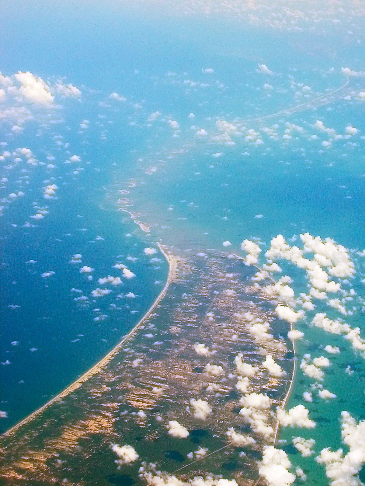
Adam's Bridge,[a] also known as Rama's Bridge or Rama Setu,[c] is a chain of natural limestone shoals between Pamban Island, also known as Rameswaram Island, off the southeastern coast of Tamil Nadu, India, and Mannar Island, off the northwestern coast of Sri Lanka. Geological evidence suggests that the bridge was formerly a land connection between India and Sri Lanka.[1]

The feature is 48 km (30 mi) long and separates the Gulf of Mannar (southwest) from the Palk Strait (northeast). Some regions of the bridge are dry, and the sea in the area rarely exceeds 1 metre (3 ft) in depth, making it quite difficult for boats to pass over it.[1]

Etymology

[edit]

Ibn Khordadbeh's Kitāb al-Masālik wa-l-Mamālik (c. 850) refers to the structure as Set Bandhai (lit. Bridge of the Sea).[2] The name Adam's Bridge appeared probably around the time of Al-Biruni (c. 1030).[2] This appears to have been premised on the Islamic belief that Adam's Peak — where the biblical Adam fell to earth — is located in Sri Lanka, and that Adam crossed over to peninsular India via the bridge after his expulsion from the Garden of Eden.[3]

The ancient Sanskrit epic Ramayana (8th century BCE–3rd century CE) mentions a bridge constructed by the god Rama to reach the island Lanka and rescue his wife Sita from Ravana. In popular belief, Lanka is equated to present-day Sri Lanka and the bridge is described as "Rama's Setu".[4]

"... his General, the Prince of Satyrs, was named Hanumat, or with high cheek-bones; and, with workmen of such agility, he soon raised a bridge of rocks over the sea, part of which, say the Hindus, yet remains; and it is, probably, the series of rocks, to which the Muselmans or the Portuguese have given the foolish name of Adam's (it should be called Ráma's) bridge."

Geological evolution

[edit]
Landsat 5 image of Adam's Bridge
NASA satellite photo: India on top, Sri Lanka at the bottom
Bathymetry of the Palk Strait, showing water depth in metres

Due to lowered sea levels during the Last Glacial Period (115,000–11,700 years Before Present) where sea levels reached a maximum of 120 m (390 ft) below present values, the entirety of the relatively shallow Palk Strait (which reaches a maximum depth of only 35 m (115 ft)) was exposed as dry land connecting the mainland Indian subcontinent and Sri Lanka. Following the rise to present sea levels during the Holocene, by around 7,000 years ago, the strait became submerged, including the region of Adam's Bridge/Rama Setu. The islands of Adam's Bridge became emergent again following sea level falls in the region from around 5,000 years ago to the present.[5]

The bridge starts as a chain of shoals from the Dhanushkodi tip of India's Pamban Island. It ends at Sri Lanka's Mannar Island. Pamban Island is accessed from the Indian mainland by the 2 km (1.2 mi) long Pamban Bridge. Mannar Island is connected to mainland Sri Lanka by a causeway.

The lack of comprehensive field studies explains many of the uncertainties regarding the nature and origin of Adam's Bridge. It mostly consists of a series of parallel ledges of sandstone and conglomerates that are hard at the surface and grow coarse and soft as they descend to sandy banks.[6] The Marine and Water Resources Group of the Space Applications Centre (SAC) of the Indian Space Research Organisation (ISRO) concludes that Adam's Bridge comprises 103 small patch reefs.[6] One study tentatively concludes that there is insufficient evidence to indicate eustatic emergence and that the raised reef in southern India probably results from a local uplift.[7]

Transport corridor

[edit]
Historical map of Adam's Bridge and environs, before the cyclone of 1964
Pearl fishing in the Gulf of Mannar, c. 1926

In the vicinity of Adam's Bridge/Rama Setu, the water is typically only 1–3 m (3 ft 3 in – 9 ft 10 in) deep.[5] Due to the shallow waters, Adam's Bridge presents a formidable hindrance to navigation through the Palk Strait. Though trade across the India–Sri Lanka divide has been active since at least the first millennium BC, it was limited to small boats and dinghies. Larger ocean-going vessels from the west have had to navigate around Sri Lanka to reach India's eastern coast.[8] Eminent British geographer Major James Rennell, who surveyed the region as a young officer in the late 18th century, suggested that a "navigable passage could be maintained by dredging the strait of Ramisseram [sic]". However, little notice was given to his proposal, perhaps because it came from "so young and unknown an officer", and the idea was only revived 60 years later.

In 1823, Sir Arthur Cotton (then an ensign) was assigned to survey the Pamban channel, which separates the Indian mainland from the island of Rameswaram and forms the first link of Adam's Bridge. Geological evidence indicates that a land connection bridged this in the past, and some Ramanathaswamy Temple records suggest that violent storms broke the link in 1480. Cotton suggested that the channel could be dredged to enable passage of ships, but nothing was done until 1828, when Major Sim directed the blasting and removal of some rocks.[9][10]

A more detailed marine survey of Adam's Bridge was undertaken in 1837 by lieutenants F. T. Powell, Ethersey, Grieve, and Christopher, along with draughtsman Felix Jones, and operations to dredge the channel were recommenced the next year.[9][11] However, these and subsequent efforts in the 19th century did not succeed in keeping the passage navigable for any vessels except those with a light draft.[1]

Sethusamudram Shipping Canal Project

[edit]
Opposition parties demanded implementation of the Sethusamudram canal project using one of the alternative alignments considered earlier by the government, without damaging the structure of Adam's Bridge.

The government of India constituted nine committees before independence, and five committees since then, to suggest alignments for a Sethusamudram canal project. Most of them suggested land-based passages across Rameswaram island, and none recommended alignment across Adam's Bridge.[12] The Sethusamudram project committee in 1956 also strongly recommended to the Union government to use land passages instead of cutting Adam's Bridge because of the several advantages of land passage.[13]

In 2005, the government of India approved a multi-million dollar Sethusamudram Shipping Canal Project. This project aims to create a ship channel across the Palk Strait by dredging the shallow ocean floor near Dhanushkodi. The channel is expected to cut over 400 km (250 mi) (nearly 30 hours of shipping time) off the voyage around the island of Sri Lanka. This proposed channel's current alignment requires dredging through Adam's Bridge.

Indian political parties including the Bharatiya Janata Party (BJP), All India Anna Dravida Munnetra Kazhagam (AIADMK), Rashtriya Janata Dal (RJD), Janata Dal (Secular) (JD(S)) and some Hindu organisations oppose dredging through the shoal on religious grounds. The contention is that Adam's Bridge is identified popularly as the causeway described in the Ramayana. The political parties and organisations suggest alternate alignment for the channel that avoids damage to Adam's Bridge.[14][15] The then state and central governments opposed such changes, with the Union Shipping Minister T. R Baalu, who belongs to the Dravida Munnetra Kazhagam and a strong supporter of the project maintaining that the current proposal was economically viable and environmentally sustainable and that there were no other alternatives.[16][17][18]

Opposition to dredging through this causeway also stems from concerns over its impact on the area's ecology and marine wealth, potential loss of thorium deposits in the area and increased risk of damage due to tsunamis.[19] Some organisations oppose this project on economic and environmental grounds and claim that proper scientific studies were not conducted before undertaking this project.[20]

Proposed Road and Rail Bridge

[edit]

The Palk Strait Bridge is a proposed road and rail sea bridge and tunnel that would cross the Palk Strait roughly over, or parallel to, Adam's Bridge. It would span from Dhanushkodi at the tip of Pamban Island in India, to Talaimannar on Mannar Island in Sri Lanka, and would be used for both industrial/economic purposes and to boost tourism. The bridge was first seriously proposed by the Indian and Sri Lankan governments in 2002, shelved after security-related objections by the then-Governor of Tamil Nadu, and revived for serious consideration in 2023.[21] As of August 2024, its status is that the feasibility studies are nearing completion.[22]

Religious significance

[edit]

Hinduism

[edit]
A 20th-century painting depicting a scene from Ramayana, wherein monkeys are shown building a bridge to Lanka
A 20th-century painting depicting a scene from Ramayana, wherein vanaras are shown building a bridge to Lanka.

The ancient Sanskrit epic Ramayana, in the Yuddhakanda, mentions a bridge constructed by the god Rama with aid from an army of Vanaras (monkeys or forest-dwellers) to reach the island Lanka and rescue his wife Sita from Ravana.

In popular belief, Lanka is equated to present-day Sri Lanka.[4] However, such a correspondence is not explicit in the Ramayana and a few verses can even be held to be against such an identification;[23] some Sanskrit sources of the first millennium emphasise on the distinction.[4] Robert P. Goldman — who edited the Princeton translation of the epic into English — characterises most of the Ramayana, including the Lanka Kanda, as "kind of [an] elaborate fairy tale" by design; attempts to probe into its historicity were misguided.[23][d] John Brockington, noted for his scholarship on Hindu epics, concurs.[24]

In extant historical sources, the equation between the two islands appears for the first time only in the Kasakudi Copper Plates of Nandivarman II (r. late-8th century) pertaining to the conquest of Sri Lanka by one of his ancestors; as Ramayana took a life of its own under the succeeding Cholas, the identification profferred, justifying their imperial ambitions to invade the island.[4] The link would then be co-opted by the Aryacakravarti dynasty of Jaffna in presenting themselves as the guardians of the bridge.[4] Nonetheless, two reputed medieval commentaries on the Ramayana — Ramanujiya (drafted c. 1500 by Ramanuja) and Tattvadipika (drafted c. 1550 by Mahesvaratirtha) — continued to make a distinction between Lanka and Sri Lanka.[25]

Islam

[edit]

Muslim tradition holds that Adam's Bridge was crossed by Adam following his expulsion from the Garden of Eden.[26][27]

Controversy over origin claims

[edit]

Religious beliefs that the geological structure was constructed by Rama have caused some controversy as believers reject the natural provenance of Adam's Bridge. S. Badrinarayanan, a former director of the Geological Survey of India,[28] a spokesman for the Indian government in a 2008 court case,[29] the Madras High Court,[30] and an episode from the Science Channel series What on Earth? have claimed that the structure is man-made.[31]

In the What on Earth? episode, those claiming that Adam's Bridge was constructed based their arguments on vague speculation, false implications, and the point that – as with many geological formations – not every detail of its formation has been incontrovertibly settled.[32] Indian Geologist C. P. Rajendran described the ensuing media controversy as an "abhorrent" example of the "post-truth era, where debates are largely focused on appeals to emotions rather than factual realities".[33][34]

NASA said that its satellite photos had been egregiously misinterpreted to make this point during the protests against Sethusamudram Shipping Canal Project. NASA noted: "The images reproduced on the websites may well be ours, but their interpretation is certainly not ours. Remote sensing images or photographs from orbit cannot provide direct information about the origin or age of a chain of islands, and certainly, cannot determine whether humans were involved in producing any of the patterns seen."[35]

A report from the Archaeological Survey of India found no evidence for the structure being anything but a natural formation.[36] The Archaeological Survey of India and the government of India informed the Supreme Court of India in a 2007 affidavit that there was no historical proof of the bridge being built by Rama.[37] In 2017 the Indian Council of Historical Research (ICHR) announced a pilot study into the origins of the structure,[38] but went on to shelve it.[39]

In 2007, the Sri Lankan Tourism Development Authority sought to promote religious tourism from Hindu pilgrims in India by including the phenomenon as one of the points on its "Ramayana Trail", celebrating the legend of Prince Rama. Some Sri Lankan historians have condemned the undertaking as "a gross distortion of Sri Lankan history".[40] The idea of Rama Setu as a sacred symbol to be appropriated for political purposes strengthened in the aftermath of protests against the Sethusamudram Shipping Canal Project.[41]

Notable past (purple) and current (orange) land bridges on a bathymetric equirectangular projection centred on 45° E [42]

See also

[edit]

Notes

[edit]

References

[edit]
[edit]
Revisions and contributorsEdit on WikipediaRead on Wikipedia
from Grokipedia
Adam's Bridge, also known as Rama Setu, is a 48-kilometer-long chain of limestone shoals forming a shallow submerged ridge that connects the southeastern tip of near in to in northwestern , separating the from the . This geological feature consists primarily of limestone, sandbanks, and sedimentary deposits, with depths generally ranging from 1 to 3 meters, rendering much of it nearly awash at low tide. Geological analyses, including bathymetric modeling and satellite altimetry data, indicate that Adam's Bridge represents the remnants of a former land connection between the and , exposed during periods of lower sea levels in the Pleistocene epoch due to tectonic stability and sediment accumulation processes. In Hindu tradition, as depicted in the ancient epic , the structure is identified as the causeway erected by 's monkey army using floating stones to reach and rescue from , attributing to it a divine and historical significance that persists in cultural reverence. , derived from empirical stratigraphic and radiometric , upholds its origin as a system formed by coastal and growth, countering unsubstantiated assertions of artificial construction that lack corroboration in peer-reviewed geological literature. The feature gained modern prominence through satellite imagery highlighting its linear alignment, sparking interdisciplinary debates, while proposals like the have highlighted tensions between navigational development, environmental impacts on marine ecosystems, and preservation of its perceived sacred status.

Geography and Physical Description

Location and Extent

Adam's Bridge consists of a chain of limestone shoals, reefs, and sandbanks extending approximately 48 kilometers between Pamban Island off the coast of Tamil Nadu, India, and Mannar Island, Sri Lanka. The structure lies within the Palk Strait, demarcating the boundary between the Gulf of Mannar to the southwest and Palk Bay to the northeast. It spans from Dhanushkodi, the southeastern tip of Rameswaram Island in India, to the northwestern region of Talaimannar in Sri Lanka's Mannar District. The feature's central coordinates are roughly at 9.1210° N and 79.5217° E , with imagery covering an area centered around 9.3° N, 79.3° E. Portions of the bridge emerge as dry sandbanks during low tide, while other sections remain submerged in shallow waters typically 1 to 3 meters deep, rendering much of it impassable to larger vessels without . The width of the chain varies, narrowing in places to form a near-continuous barrier that historically connected the Indian mainland to before post-glacial . Recent bathymetric models indicate the ridge's length may be measured as short as 29 to 30 kilometers for the primary submerged portion, though traditional surveys account for the full extent including flanking shallows.

Geological Composition

Adam's Bridge consists of a chain of shallow limestone shoals stretching approximately 29 kilometers between in and in [Sri Lanka](/page/Sri Lanka). These shoals are primarily composed of sedimentary , formed from the accumulation of deposits originating from marine organisms such as corals and . Interspersed among the limestone formations are coral reefs and sandbanks, where coral growth has trapped finer sediments, contributing to the discontinuous and irregular structure of the bridge. The overall composition reflects typical tropical marine depositional environments, with the limestone exhibiting and layering characteristic of . Water depths over the shoals average between 1 and 10 , exposing the upper layers to wave action that has shaped the surface into low-relief banks and patches, with occasional emergent islands. Geological surveys indicate no evidence of non-sedimentary or artificial materials in the core composition, aligning with reef and development in the region.

Sea Level and Visibility Changes

During the around 22,000 years ago, global s were approximately 120–130 meters lower than present due to extensive ice sheet coverage, exposing the shallow and integrating Adam's Bridge into a continuous land connection between mainland and . This exposure facilitated terrestrial migration and sediment deposition, with the bridge's shoals forming part of the emergent shaped by wave action and atoll development during repeated Pleistocene sea level oscillations. Post-glacial triggered rapid , reaching near-modern levels by the mid-Holocene around 7,500–7,000 years , which submerged the and reduced Adam's Bridge to a chain of submerged shoals with depths typically ranging from 1 to 10 meters. The maximum depth in the surrounding strait is about 35 meters, meaning even minor fluctuations could historically expose or conceal segments, though bathymetric data indicate the bridge's core structure persisted as a near-linear ridge due to resistant calcareous and coral resistant to . In modern times, the bridge's visibility is enhanced by and aerial , revealing its 48-kilometer extent as discontinuous shoals amid turbid waters, with imagery from 2002 highlighting sediment-disrupted patterns during seasonal monsoons. Ongoing global , averaging 3–4 millimeters per year in the region, poses minimal immediate threat to its shallow profile but could exacerbate and sedimentation shifts, potentially altering surface visibility without significantly deepening the structure. Local tidal ranges of 0.5–1 meter further influence short-term exposure, particularly during neap tides when calmer conditions allow clearer observation of emergent patches.

Etymology and Historical Naming

Islamic Legend and "Adam's Bridge"

In Muslim tradition, Adam's Bridge is associated with the biblical figure (known as Ādam in ), who, following his expulsion from the , is said to have crossed the structure to reach (Sri Pada) in , where he repented by standing on one foot for a thousand years. This narrative posits as the site of Adam's initial descent to Earth, with the bridge serving as a divinely provided path linking the island to the Indian mainland, enabling his penitential journey amid separation from , who landed in Arabia. The legend draws from extra-Quranic folklore rather than core Islamic scriptures, reflecting interpretive traditions that localize paradise's aftermath in , though such accounts lack empirical corroboration and vary in details across medieval texts. The naming of the feature as "Adam's Bridge" derives from this lore, with the earliest documented reference appearing in the Persian scholar Al-Biruni's Tārīkh al-Hind (c. 1030 CE), where it is described in connection to Adam's traversal post-expulsion. Prior Arabic geographic works, such as Ibn Khordadbeh's Kitāb al-Masālik wa-l-Mamālik (c. 850 CE), referred to it neutrally as Set Bandhai ("Bridge of the Sea"), without the Adamic attribution, indicating the legend's influence emerged later in Islamic cartographic and travel literature. European colonial maps from the onward adopted the term, perpetuating it in Western nomenclature despite its rootedness in unverified tradition rather than observed geography. This etymology underscores how religious narratives shaped pre-modern place names, often prioritizing symbolic over material explanations in the absence of systematic surveying.

Hindu Tradition and "Rama Setu"

In Hindu tradition, the limestone shoals forming Adam's Bridge are regarded as the remnants of Rama Setu, a bridge constructed by the vanara army under 's command to cross the sea to , as narrated in the epic . The Valmiki Ramayana, in its Yuddha Kanda, describes the bridge-building effort led by the vanara architect , who instructed the army to hurl trees and mountains into the ocean to form a . Tradition holds that the stones used floated miraculously, some inscribed with Rama's name, enabling rapid construction over five days to span approximately 100 yojanas in length and 10 yojanas in width. The purpose of Rama Setu was to facilitate Rama's invasion of Lanka to rescue his wife Sita from the demon king Ravana, culminating in Rama's victory and the restoration of dharma. This narrative underscores themes of devotion, ingenuity, and divine intervention, with Nala's engineering attributed to a boon from Vishnu allowing materials to float. The bridge, also termed Nala Setu after its builder, symbolizes Rama's determination and the collective effort of his allies, including Hanuman. Devout view the physical Adam's Bridge as sacred evidence of these events, associating it with pilgrimage sites like , where is said to have worshipped before the crossing. The tradition persists in cultural memory, influencing opposition to projects that might damage the structure, seen as an act of desecration against a site of historical and spiritual import dating to the , estimated around 1.7 million years ago in some interpretations of Hindu chronology.

Colonial and Modern References

The designation "Adam's Bridge" gained prominence in European cartography during the late 18th and early 19th centuries, adapting Islamic legends positing that Adam traversed the shoals from (site of ) to after his expulsion from Eden. This nomenclature, rooted in accounts traceable to circa 1030 CE, was first systematically applied in British surveys by , Surveyor General of and early geographer of , who labeled the feature as such in maps produced around 1804–1805. British colonial records frequently referenced Adam's Bridge in navigational and engineering assessments, reflecting its impediment to shipping in the . In 1823, engineer conducted a survey of the adjacent Pamban channel, documenting the structure's shallow depths (typically 1–10 meters) and proposing modifications for passage, though early attempts from 1838 onward proved infeasible due to the composition. Colonial hydrographic charts, such as those by the British Admiralty, perpetuated the name through the , prioritizing practical utility over local Hindu designations like Rama Setu. In modern contexts, "Adam's Bridge" persists in international scientific literature and nautical charts, as seen in reports and from 2002, which highlighted its linear morphology but affirmed a natural sedimentary origin without endorsing mythological interpretations. However, post-independence has seen advocacy to supplant it with "Rama Setu," viewing the former as a colonial that marginalizes indigenous narratives; this intensified during the 2005 Sethusamudram canal project debates, where environmental and cultural preservation arguments cited the structure's 1,750,000-year geological timeline per carbon dating of samples. Such efforts underscore tensions between empirical hydrographic naming and cultural reclamation, with no consensus shift in global usage.

Geological Formation

Natural Sedimentary Processes

The formation of Adam's Bridge involves the deposition of calcareous sands, fragments, and biogenic through marine hydrodynamic processes in the shallow . Tidal currents, reaching velocities up to 2-3 knots, transport sediments from adjacent coastal zones, including the and , where the strait acts as a natural sedimentation basin with deposition rates estimated at 1-2 mm per year in some areas. along the Indian and Sri Lankan shores contributes to this accumulation, directing sand and shell debris northward and southward, respectively, fostering the buildup of elongate shoals aligned with prevailing current patterns. Biogenic sedimentation plays a complementary role, with coral reefs in the region—dominated by species such as Porites and —undergoing growth, breakage, and fragmentation due to wave action, yielding rubble that lithifies into the characteristic strata observed in core samples. These processes are evident in drillings revealing coral bases transitioning to decayed limestones overlain by unconsolidated , with layers showing sorting indicative of selective deposition by oscillatory flows rather than uniform artificial placement. Wave and in the low-energy environment of the strait further promote localized settling, preventing widespread dispersal and enabling heights of 1-10 meters above the . Ongoing sediment dynamics, including seasonal monsoon-driven resuspension and re-deposition, maintain the bridge's intermittent emergence, as documented in bathymetric surveys showing variability in shallow patches less than 1 meter deep. These natural mechanisms align with formation models, where sediment supply from rivers like the Vaigai and long-term trapping by tidal asymmetry sustain the structure without requiring external intervention. Empirical data from radiocarbon-dated cores indicate deposition episodes spanning , consistent with gradual sedimentary accretion rather than rapid construction.

Evidence from Post-Glacial Sea Level Rise

During the , approximately 20,000 years ago, global sea levels were about 125 meters lower than present due to extensive continental ice sheets, exposing the shallow and the proto-Adam's Bridge as dry land connecting the Indian mainland to . This exposure integrated the region into a broader terrestrial , with the area's maximum depths of around 35 meters in the Palk Strait basin remaining . Post-glacial deglaciation triggered rapid eustatic sea-level rise, with seawater encroaching into the starting around 8,500 years (), transitioning the area from a freshwater-dominated to a marine environment. By the early to mid-Holocene, between 11,000 and 7,000 years , sea levels rose approximately 45 meters, burying fluvial channels and submerging the , including Adam's Bridge, which averages depths of less than 10 meters with crests as shallow as 1-4 meters. High-resolution bathymetric surveys, such as those derived from data, reveal undulating topography and asymmetrical slopes on Adam's Bridge, overlain by conglomerates, sands, and coral reefs up to 7-9 meters thick, evidencing sedimentation driven by wave energy, currents, and repeated fluctuations rather than structural integrity from human intervention. These features indicate that the bridge's current configuration resulted from the final transgression around 7,000 years , when the connection became fully navigable only by watercraft.

Recent Mapping and Studies

In June 2024, researchers published a high-resolution digital bathymetric elevation model (DEM) for Adam's Bridge derived from NASA's ICESat-2 satellite photon data, enabling seafloor detection up to approximately 40 meters depth with vertical accuracies ranging from 0.20 to 0.89 meters. This model interprets the structure as a submerged ridge comprising a chain of limestone shoals extending about 29 kilometers between Rameswaram Island, India, and Mannar Island, Sri Lanka. Concurrently, scientists at the Indian Space Research Organisation's (ISRO) produced the first comprehensive undersea map of the entire feature using six years of data, achieving a 10-meter resolution. The mapping confirms a continuous ridge rising 8 meters above the seabed, linking on the Indian side to on the Sri Lankan side, with shallow waters overlaying the shoals. These findings align with prior satellite observations, such as NASA's 2022 imagery depicting the 48-kilometer chain of shoals and sandbars. The ICESat-2-based analyses highlight the bridge's irregular , including varying heights and deposition patterns consistent with natural marine processes, without evidence of anthropogenic construction. Such mapping enhances understanding of post-glacial sea-level dynamics in the region, supporting models of sedimentary accretion during lower sea levels.

Religious and Mythological Significance

Role in Hindu Epics

In the Ramayana, attributed to the sage Valmiki and composed around the 5th century BCE to 3rd century CE, Adam's Bridge is traditionally identified as Rama Setu, the bridge constructed by the vanara army under Lord Rama's command to cross the sea to Lanka during the war against Ravana. This structure plays a pivotal role in the Yuddha Kanda, the final book of the epic, enabling Rama's forces to invade Lanka and rescue Sita, Rama's abducted wife, from the demon king Ravana. The construction begins after the ocean refuses to yield a path despite Rama's initial threat to dry it up with divine arrows; the sea god then advises building a bridge instead. Supervised by , the son of the divine architect , the vanaras—monkey-like beings allied with —hurl massive trees, rocks, and even mountain peaks into the water, which miraculously float due to inscriptions of Rama's name or divine intervention. The epic describes the bridge as 100 yojanas in length and 10 yojanas in width, completed in five days through relentless labor involving millions of workers. Once finished, the bridge facilitates the rapid crossing of Rama's army, comprising ten core divisions, setting the stage for the climactic battles that culminate in Ravana's defeat and the restoration of . This episode symbolizes human (and divine) ingenuity overcoming natural barriers, emphasizing themes of devotion, collective effort, and triumph over adversity central to the 's narrative.

Islamic Narratives

In regional Muslim folklore, particularly among trading communities in and southern , Adam's Bridge is linked to the biblical figure of (known as Ādam in ) following his expulsion from Paradise. According to this tradition, Adam descended to Earth on (Sri Pada) in central Sri Lanka, where his footprint is said to be imprinted in a rock formation, and he subsequently crossed the shoals of Adam's Bridge to reach the Indian mainland. The narrative posits that Paradise was located atop Adam's Peak, and after the expulsion, Adam was separated from Eve (Hawwa'), who landed elsewhere—sometimes specified as near Jeddah in Arabia or the Indian mainland—leading to a period of penitence where Adam stood on one foot for a thousand years before traversing the bridge to reunite with her or seek forgiveness. This account emerged among early Arab Muslim traders who interacted with the region, associating the visible chain of islets with Adam's path, though directions of crossing vary in retellings, with some describing movement from to . However, this association lacks foundation in core Islamic texts; neither the nor authentic mention Adam's Bridge, Adam's Peak, or any specific landing site for on Earth beyond a general descent to the terrestrial realm. Scholars emphasize that such localized legends, while culturally persistent in Asian Muslim communities, represent rather than scriptural doctrine, often blending with pre-existing regional myths.

Broader Cultural Interpretations

In Christian traditions, Adam's Bridge is interpreted as the path traversed by Adam after his expulsion from the Garden of Eden, paralleling Islamic narratives but documented through colonial-era cartography influenced by European and Arabian accounts. This association, stemming from biblical lore of Adam's descent and journey from —linked to —to mainland , underscores a shared Abrahamic motif of human origins and exile, though lacking direct scriptural references in the itself. Sri Lankan folklore offers a contrasting interpretation, attributing the bridge's construction to Ravana, the demon king of the Ramayana, who purportedly used floating pumice rocks to form it, inverting the Hindu narrative where Rama's forces build the structure. This local variant reflects cultural adaptations in predominantly Buddhist Sri Lanka, emphasizing Ravana's ingenuity and regional pride, as evidenced in oral traditions and tourism narratives that highlight pumice's buoyancy properties. Beyond specific religious attributions, Adam's Bridge symbolizes enduring cultural connectivity between and , representing historical migration routes, shared maritime heritage, and a that fostered distinct yet intertwined identities. In modern contexts, it evokes themes of ecological sacrality and performative heritage, where the formation's visibility at inspires rituals, , and debates on preservation versus development, bridging ancient myths with contemporary Indo-Lankan relations.

Origin Debates and Evidence

Scientific Consensus on Natural Formation

![NASA satellite image of Adam's Bridge shoals][float-right] The scientific consensus holds that Adam's Bridge, a 48-kilometer chain of limestone shoals extending from Rameswaram Island in India to Mannar Island in Sri Lanka, originated through natural sedimentary and biogenic processes rather than artificial construction. Geological analyses indicate formation via deposition of calcium carbonate from coral reefs and shelly sands, accumulated by tidal currents and wave action in the shallow Palk Strait over millennia. Core samples and from the reveal layered marine sediments dating back approximately 144,000 years, with sea levels 118 meters below present during lowstands, exposing the feature as dry land before post-glacial transgression submerged it around 18,000 years ago. Bathymetric surveys confirm irregular depths of 1-10 meters across the shoals, consistent with ongoing influenced by monsoon-driven currents transporting from adjacent bays, rather than uniform engineered placement. Studies utilizing satellite altimetry, such as data from 2024, map the ridge's morphology as a dynamic, sediment-dominated structure with no evidence of anthropogenic materials or anomalous alignments defying hydrodynamic principles. This view aligns with broader plate tectonic and eustatic models, where the bridge represents a relict or barrier system shaped by sea-level fluctuations, corroborated by similar formations in the . Claims of artificial origins lack empirical support from these geophysical datasets, which prioritize causal mechanisms like , accretion, and biogenic buildup over speculative interpretations.

Arguments for Artificial Construction

Proponents of artificial construction primarily draw from the ancient Hindu epic , attributed to and dated between the BCE and CE, which describes the vanara army under Lord constructing a bridge to using stones that floated when inscribed with Rama's name, completed in five days over approximately 100 yojanas (roughly 1,200-1,500 km, though modern interpretations adjust for poetic scale to match the 48 km feature). This narrative aligns with the bridge's location between and Mannar, leading advocates to argue it corroborates historical engineering by an advanced ancient civilization or divine intervention, rather than myth. Geological arguments cite borehole explorations conducted by S. Badrinarayanan, former director of the , who in 2007 drilled 10 sites along the alignment and found a layer of loose marine sand beneath , overlain by older and rock formations up to 6 meters thick, suggesting the structure predated and supported subsequent natural accretion rather than forming via gradual . Similarly, Indian geologist Desh Kapoor analyzed the layering, noting that the upper stones dated older than those below, inverting the expected natural sequence where newer deposits overlay older ones, which he interpreted as evidence of deliberate placement in a rock-filled . Radiocarbon dating of samples provides temporal support, with some analyses indicating the core rocks age around 7,000 years while overlying sand dates to 4,000 years, implying human intervention around 5,000 BCE followed by natural covering, consistent with revised historical timelines for the events based on astronomical correlations. The structure's linear alignment over 48 km, visible in satellite imagery as a chain-like formation with minimal deviation, is cited as improbably uniform for random tidal deposition, suggesting engineered precision. A 2017 Science Channel investigation claimed the bridge's composition includes transported rocks unsuitable for local formation, with isotopic analysis indicating sourcing from distant quarries, bolstering man-made transport hypotheses over in-situ natural processes. Proponents further point to pumice-like stones capable of floating, matching epic descriptions, and minimal biofouling on submerged elements, arguing submersion post-construction limited marine encrustation compared to adjacent natural reefs. These claims, often from non-peer-reviewed or alternative sources, contrast mainstream geological consensus but persist in debates linking empirical anomalies to ancient construction feats.

Empirical Data and Rebuttals to Non-Scientific Claims

Geological analyses confirm that Adam's Bridge consists primarily of natural shoals, reefs, and , with depths ranging from 1 to 10 meters in most areas, formed through sedimentary deposition and marine accretion processes. Bathymetric surveys indicate a gradual underwater ridge extending 29 kilometers, with an average height of 8 meters from the seabed, aligning with patterns of post-glacial fluctuations that exposed a land connection between and during the Pleistocene , approximately 18,000 to 7,000 years ago. Carbon-14 dating of samples and nearby sediments yields ages of 3,500 to 18,400 years for surface features, while deeper core samples reveal older sedimentary layers consistent with tectonic uplift and rather than engineered placement. Empirical evidence from the (ASI), including subsurface probes and sediment analysis, detects no artifacts, tool marks, or anomalous materials indicative of human construction, only unconsolidated marine deposits typical of shallow-water carbonate platforms. and stratigraphic profiling further demonstrate discontinuous layering from tidal currents and biogenic accumulation, refuting uniform block construction; for instance, seismic refraction data shows variable and no foundational engineering. Non-scientific claims positing artificial origins, such as those deriving from the Ramayana epic describing a bridge assembled by vanara armies using floating stones invoked with divine names, lack verifiable physical correlates and contradict observed sedimentology, as no such lightweight or inscribed materials appear in dredged samples. Assertions of precise alignment with epic timelines—e.g., a 7,000-year construction matching carbon-dated beaches—are coincidental at best, as bridge core ages predate human technological capacity for large-scale marine engineering by millennia, with no transitional artifacts from the purported era. Misattributed endorsements, including viral interpretations of NASA satellite imagery as evidence of man-made design dating to 1.75 million years ago, have been explicitly disavowed by NASA officials, who state that their depicts natural formations without implying artificiality or specific antiquity beyond geological norms. Similarly, studies emphasizing epic overlook that sea-level regressions explain the feature's morphology without invoking causation, as comparable submerged ridges exist globally from eustatic changes. Claims of "unbreakable" or divinely engineered durability fail empirical tests, given documented and breaches from cyclones, such as the 1964 event that deepened channels to 12 meters. These mythological interpretations, while culturally resonant, do not supersede direct observational from mapping and geochemical assays confirming abiogenic origins.

Economic and Infrastructure Proposals

Sethusamudram Shipping Canal Project

The Sethusamudram Shipping Canal Project proposes dredging a navigable channel through the Palk Strait and Adam's Bridge shoals to connect the Gulf of Mannar with Palk Bay, enabling ships to bypass the circumnavigation of Sri Lanka. This would reduce sailing distance by approximately 400 kilometers and travel time by 30 to 36 hours for vessels between India's east and west coasts or en route to eastern destinations. The project, initially conceived in 1860 during British colonial rule, gained renewed attention in the late 20th century with feasibility studies emphasizing economic benefits such as fuel savings, reduced port congestion at Tuticorin, and enhanced regional trade. Several alignments were evaluated, with the primary Sethusamudram Corporation Limited (SSCL) route requiring through parts of Adam's Bridge over a total channel length of about 152 kilometers, divided into phases including a 35-kilometer deep-water section and shallower cuts up to 12 meters. Alternative routes, such as Setu Kachchativu (SKB) and Thalaiyari-Thirikkawali (TTK), were proposed to minimize impacts on the shoals while achieving similar navigational goals, though these extended the channel length and increased volumes. Proponents projected annual traffic of up to 7,141 vessels by 2025, primarily smaller ships under 10,000 DWT, arguing it would alleviate reliance on Sri Lankan and boost local economies through employment in and operations. However, feasibility critiques noted that larger modern container vessels exceeding the channel's draft and width limits would still detour around , limiting benefits and questioning projected traffic volumes. Environmental assessments highlighted risks to the Reserve, a UNESCO-recognized area spanning 10,500 square kilometers with rich including like dugongs, sea turtles, and over 400 fish varieties. could disrupt flows, increase , and alter water exchange between the Gulf and , potentially harming fisheries that support thousands of livelihoods in and . Initial environmental clearances in 2005 were contested for inadequate impact studies, leading to interventions and committee reviews that flagged insufficient evaluation of long-term ecological effects. The project faced legal and cultural opposition, particularly from groups viewing Adam's Bridge as the sacred Ram Setu from Hindu epics, prompting petitions that halted dredging in 2007-2008. In 2018, the Indian government informed the it would prioritize non-Setu routes to proceed in the national interest, avoiding damage to the structure. As of 2023, implementation remains stalled due to unresolved court cases, revised environmental concerns, and geopolitical sensitivities with , with no dredging resumed despite periodic calls for revival from political figures.

Road and Rail Bridge Concepts

Proposals for a road and rail bridge across the , leveraging the shallow waters of Adam's Bridge, have emerged as a means to enhance physical connectivity between and . The concept envisions a multi-modal link spanning approximately 23 kilometers from in , , to points near Mannar or in northern , potentially incorporating bridge and tunnel segments to navigate the shoals. Estimated costs for the project hover around $5 billion, with discussions focusing on , including improved , , and passenger mobility without reliance on ferries or air travel. Initial feasibility studies for such infrastructure were floated by Indian authorities as early as the , but gained renewed traction in bilateral talks during 2024. In line with broader India- connectivity initiatives, Sri Lankan proposals have included an over-sea land bridge from , aligning with historical rail links severed by cyclones in 1964 and earlier breaches of the natural shoals. Indian ministers announced plans for a detailed feasibility assessment of a road connection between and , emphasizing engineering viability in the shallow depths averaging 1-10 meters. Proponents argue the bridge could reduce travel times dramatically, fostering regional supply chains and countering maritime chokepoints, though critics highlight risks of debt dependency for Sri Lanka amid its economic recovery. By April 2025, expressed reservations, with officials deeming the land bridge proposal premature due to unresolved issues like funding models, environmental impacts, and concerns over unrestricted access. Despite intermittent revivals in negotiations, including rail-specific surveys for a Dhanushkodi-Mannar line, no construction has commenced, hampered by geopolitical sensitivities and the site's cultural resonance as Rama Setu in Hindu tradition. Alternative alignments, such as tunneling beneath deeper channels, have been considered to minimize ecological disruption, but political consensus remains elusive as of late 2025.

Environmental and Heritage Objections

The Sethusamudram Shipping Canal Project has faced significant environmental opposition due to its potential to disrupt the Gulf of Mannar Biosphere Reserve, a UNESCO-recognized area spanning 10,500 km² with unique biodiversity including over 400 endangered species such as dugongs, sea turtles, dolphins, and corals. Dredging operations would remove approximately 85 million cubic meters of seabed material, stirring up sediments laden with toxins and heavy metals, which could contaminate the shallow waters of Palk Bay and Gulf of Mannar, leading to eutrophication, oxygen depletion, and mass die-offs of marine life. Critics, including marine biologists and Sri Lankan environmental groups, argue that the project's alignment through ecologically fragile shallows—averaging 1-10 meters deep—would alter tidal flows, increase rates, and destroy beds essential for fisheries supporting over 50,000 livelihoods in and northern . The region’s vulnerability to cyclones, as evidenced by historical events like the 1964 and 2004 storms, could exacerbate erosion and amplify hydrodynamic instability in the proposed 35-meter-deep channel, potentially rendering it unnavigable during monsoons and harming adjacent coral reefs. Independent assessments, such as those by the Biosphere Reserve Trust, highlight unaddressed risks to migratory species and stocks, with modeling indicating long-term outweighing projected shipping efficiencies. Heritage objections center on the site's identification in Hindu tradition as Ram Setu, the bridge constructed by Lord Rama's forces in the epic to reach Lanka, rendering dredging tantamount to cultural desecration. Advocacy groups, including petitions filed by figures like , have urged the Indian government to declare Adam's Bridge a national heritage monument, citing its submersion around 1480 CE as per geological surveys and its enduring symbolic role in . The passed a 2007 resolution opposing the project on grounds of faith and historical continuity, arguing that alternative alignments—proposed as early as British colonial surveys—avoid such destruction without economic loss. These concerns contributed to legal halts, including interventions in 2007-2008 directing consideration of non-Ram Setu routes and a 2018 government affirming no damage to the structure in , effectively stalling amid unresolved ecological and cultural claims. Similar heritage sensitivities apply to road and rail bridge proposals, though less formalized, with proponents of preservation emphasizing the chain's role in regional pilgrimage circuits linking Rameswaram and Sri Lanka's traditions.

Contemporary Developments and Ecology

Recent Scientific Surveys

In 2024, researchers from the Indian Space Research Organisation's utilized data from NASA's satellite to produce the first high-resolution digital bathymetric model (DBEM) of Adam's Bridge, enabling detailed analysis of its submerged topography. This model, derived from seafloor-returned photons, spans the 29 km length of the structure and reveals a maximum of 8 meters above the , with intricate variations in depth and slope across the region. The accompanying geophysical interpretation highlighted asymmetrical transverse slopes on either side of the bridge, with steeper gradients toward the indicating predominant sediment transport and energy transgression from the . Three-dimensional visualizations from the DBEM data confirmed the chain-like configuration of shoals, composed primarily of and remnants, without of uniform artificial layering. These findings build on prior bathymetric efforts but offer unprecedented precision due to ICESat-2's photon-counting , which penetrates shallow waters up to 30 meters. The surveys underscore ongoing natural and deposition processes shaping the feature, with no peer-reviewed data from this effort supporting anthropogenic origins.

Ecological Importance and Biodiversity

Adam's Bridge consists of shallow limestone shoals with depths typically ranging from 1 to 3 meters at low tide, creating a unique subtropical marine environment that fosters high biodiversity. These conditions support coral reefs, seagrass meadows, and algal beds, which serve as foundational habitats for various marine organisms. The region harbors diverse fauna, including over 3,600 species of aquatic flora and fauna in the adjacent Gulf of Mannar and Palk Bay ecosystems, such as 117 coral species, dugongs, sea turtles, dolphins, and sharks. Adam's Bridge acts as a nursery ground for commercially important fish and crustaceans, sustaining fisheries vital to coastal communities in India and Sri Lanka. Endangered species like the dugong (Dugong dugon) rely on the seagrass beds for foraging, while migratory birds utilize the shoals as resting sites. Ecologically, the bridge influences local hydrodynamics by acting as a natural barrier that moderates currents, , and nutrient distribution between and the , thereby maintaining water quality and protecting sensitive coastal habitats from excessive wave action. This role enhances resilience against erosion and supports the productivity of surrounding forests and estuaries. The area falls within protected zones, including Sri Lanka's , established to conserve these hotspots amid threats like proposals.

Tourism and Conservation Efforts

Tourism to Adam's Bridge primarily occurs from the Indian side via , a coastal town approximately 20 kilometers from , where visitors access the site by due to the lack of paved roads. Tourists can view the submerged shoals, often associated with the mythological Ram Setu, and engage in activities such as boat rides to observe the structure from . Access is restricted to daylight hours, typically from 8 a.m. to 5 p.m., with around 500 daily visitors on average, increasing during festivals and full moon days. On the Sri Lankan side, the area features beaches linked to historical and legendary narratives, attracting visitors interested in coastal exploration. Recreational pursuits like and diving are available in surrounding waters, highlighting the site's geological and marine appeal despite limited infrastructure. Conservation efforts include the establishment of Adam's Bridge in on June 22, 2015, as one of four new aimed at wildlife preservation. This park functions as a transboundary with , enabling ecosystem-wide habitat and species protection across the and . In 2024, Management Effectiveness Tracking Tool (METT-4) assessments were conducted for the park and adjacent marine protected areas to evaluate conservation status. Surveys have documented breeding colonies of terns on Indian-side sandbars, underscoring the need for monitoring migratory birds and marine biodiversity amid threats like from , which has impacted local waters and . Efforts emphasize preserving the site's physical and cultural significance while addressing environmental challenges in the ecosystem.

References

Add your contribution
Related Hubs
User Avatar
No comments yet.