

Community hub
Recent from talks
Contribute something
Nothing was collected or created yet.
Key Information


Ātiu, also known as ʻEnuamanu (meaning land of the birds), is an island of the Cook Islands archipelago, lying in the central-southern Pacific Ocean. Part of the Nga-pu-Toru, it is 214 km (133 mi) northeast of Rarotonga. The population of the 26.9 square kilometres (10.4 sq mi) island has dropped by two-thirds in the last 50 years.
Geography
[edit]
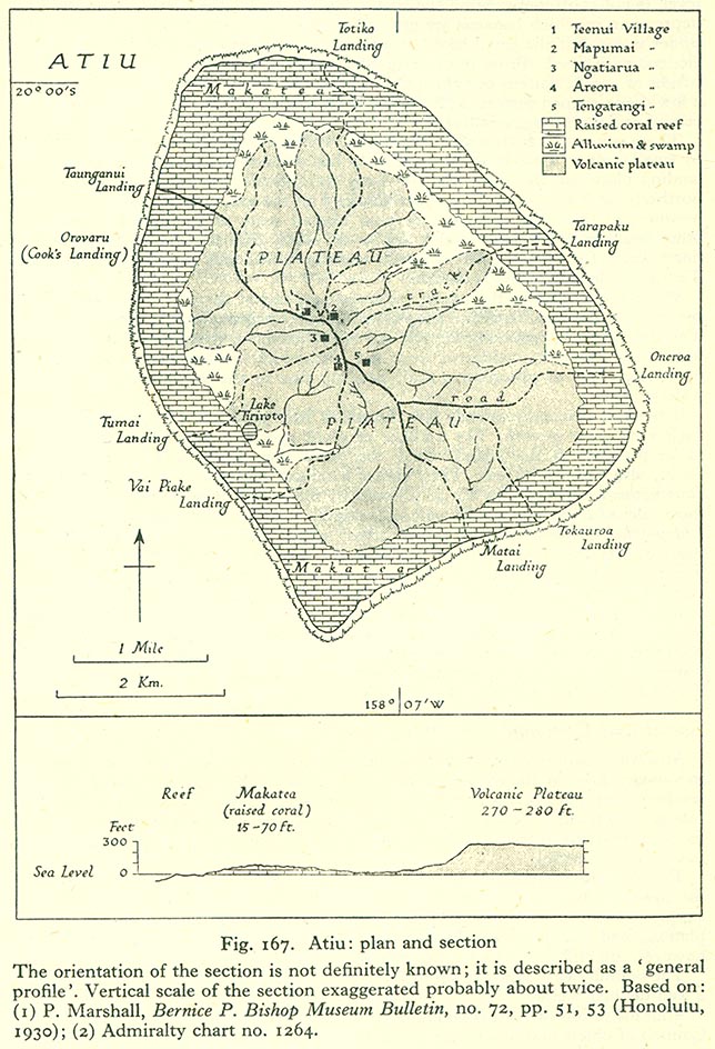
Atiu is a raised volcanic island surrounded by a reef from which rise 100-foot-high (30-metre) cliffs of fossilized coral (makatea).[2] The makatea cliff forms a zero-point-five-mile-wide (0.80-kilometre) ring round the island, creating a virtual plateau. Erosion of the inside of the ring has formed a dip of about 30 metres (98 feet) into fertile land, which gradually rises again to a central 70-metre-high (230-foot) flat-topped hill.[2] The low swampy land consists of taro plantations, marshes and a lake, Tiroto. This fertile area also grows bananas, citrus fruits, pawpaws, breadfruit and coconuts.
The island is surrounded by a 300-foot-wide (91-metre) fringing reef.[2] The makatea is honeycombed with caves, some of which have been used for burials.[3]
History
[edit]Polynesians are believed to have lived on Atiu since at least 900 or 1000 AD.[4] According to oral tradition, Atiu is named for the first man on the island, who was fathered by Tangaroa.[5] Other traditions identify various settlers, including Te Ariki-Mou-Taua, Mariri, and Nuku-kere-i-manu, as well as a visit by the navigator Ruatapu.[5] The island was unified in c.1760, and subsequently invaded and dominated neighbouring Mauke and Mitiaro.[5][6]
The first recorded European to arrive at Atiu was Captain Cook. He sighted the island on 31 March 1777, and made tentative contact with some of the people over the next few days.[5] In early 1823 the missionary J.M. Orsmond left two Boraboran teachers on the island. Later that year John Williams of the London Missionary Society arrived and converted the island's leader, Rongomatane Ngaakaara Ariki, to Christianity.[5] This resulted in the island's population being resettled in a single settlement in its centre.[7] Conversion saw Atiu's dominance of its neighbours fade.[8]
In the 1860s Ngamaru Rongotini Ariki, ariki of Atiu, Mauke and Mitiaro, married Makea Takau Ariki, a Rarotongan ariki. As a result, in 1871 Atiu became part of the Kingdom of Rarotonga. In 1888 it became a British protectorate as part of the Cook Islands Federation.[9] In 1901 it was annexed by New Zealand.[5] Post-annexation the island exported oranges, coffee and copra, but exports were disrupted by poor shipping, and collapsed in the 1950s.[10] The citrus industry was revived in the 1960s, but declined again in the 1970s.[11] Lack of economic opportunity had already begun to drive emigration to Rarotonga in the 1950s,[12] and the economic crisis of 1995 and 1996 and subsequent public sector reforms has led to the island's depopulation.[13]
Demographics
[edit]
Most human settlements are concentrated on the central hill. On 12 March 2003, the population of Atiu was 571, in five villages radiating out from the island's centre, giving the appearance of a human figure. The villages have essentially grown together into one since 1823. They represent the tapere subdivisions prior to European contact.[14] With their traditional names, the villages are:
- Teenui Village (Te-Kuru-Kava-Nui)
- Mapumai Village (Mapumai-Nui-O-Ruavari)
- Ngatiarua Village (Mokoero-Nui-O-Tautipa)
- Areora Village (Areora-Nui-Te-Are-O-Tangaroa)
- Tengatangi Village (Taturoa-I-Te-Puta-Marama)
Each of the five villages in Atiu – visitors may not distinguish one from the other – has a meeting house which is very important to them. They are well maintained and the villagers have pride in them. In these houses they conduct village meetings and community functions like welcoming and feeding visitors, selling of products. Educational courses are conducted in these houses and when a big group from overseas visit they could be accommodated in here for the time they are on the island.[15]
| Year | Pop. | ±% |
|---|---|---|
| 1906 | 918 | — |
| 1916 | 759 | −17.3% |
| 1926 | 933 | +22.9% |
| 1936 | 1,086 | +16.4% |
| 1951 | 1,270 | +16.9% |
| 1961 | 1,266 | −0.3% |
| 1966 | 1,327 | +4.8% |
| 1976 | 1,312 | −1.1% |
| 1986 | 957 | −27.1% |
| 1996 | 956 | −0.1% |
| 2001 | 623 | −34.8% |
| 2006 | 570 | −8.5% |
| 2011 | 480 | −15.8% |
| 2016 | 434 | −9.6% |
| Source:[1] | ||
Administratively, the small uninhabited island of Takutea, now a bird sanctuary, is considered part of Atiu.[16]
Culture
[edit]The Atiuans call themselves Toke-enua no Enuamanu ("worms of Enuamanu") because they were born on Atiu and hope to be buried there. There was once a custom on Atiu similar to that of New Zealand Māori of burying a newborn child's placenta under a newly planted tree. This is the origin of the Atiuan saying: "We come from the land and go back to the land."[17]
96% of the population identify themselves as Cook Islanders.[18] 49.6% identify themselves as affiliated with the Cook Islands Christian Church, 21.3% as Roman Catholic, and 13.9% as Seventh-day Adventist.[19]
A local custom is the tumunu or bush beer party. Brewing was introduced to the island by whalers, but the consumption of alcohol was banned by the missionaries and remained illegal until the 1980s, leading to a culture of secret brewing in the jungle.[20][21] Originally organised as a secret society, the tumunu is now marketed as a tourism experience.[22][23]
Economy
[edit]Atiu's economy is heavily government-supported, with 50% of the workforce employed by the public sector.[24] Following the collapse of the citrus industry and subsequent depopulation of the island, facilities are limited to a few shops, a lodge, and one motel.[24] There is some tourism, and Atiu is the second most-visited outer island after Aitutaki.[24] A new plant nursery was opened in 2020.[25]
Atiu is connected to the rest of the Cook Islands by Enua Airport and a wharf at Taunganui Harbour.
Previously powered by diesel generators, since 2018 it has been powered by a solar-battery power station.[26][27]
Coffee
[edit]Atiu has a long history of growing coffee. Missionaries established it commercially in the early 19th century. By 1865, annual exports of coffee from the Cook Islands amounted to 30,000 pounds. The islands' ariki (high chiefs) controlled the land used for planting and received most of the returns. The commoners often saw little if any reward for their labour. In the late 1890s, Rarotongan coffee production suffered due to a blight that affected the plants. Coffee production declined and had to rely more on crops from the outer islands Atiu, Mauke and Mangaia. World Wars I and II resulted in a further export reduction and eventual standstill.
In the 1950s the co-operative movement in the Cook Islands resulted in the re-establishment of coffee as a cash crop. On Atiu, under the supervision of New Zealand Resident Agent Ron Thorby and the Cook Islands Agriculture Department, new coffee plantations were established. The raw coffee was destined for export to New Zealand where it was processed and marketed.
By 1983, the coffee industry had collapsed. Government stepped back and left the plantations to their landowners. The poor financial return from selling their coffee to a Rarotongan company for processing had prompted the farmers to stop production except for their own private use. The plantations were overgrown with creepers.
Commercial coffee production was revived sometime in 1984, with the founding of Atiu Coffee Factory Ltd.[28] by German economist Juergen Manske-Eimke.[29] In 2012, the Atiu Coffee Factory managed 39 hectares (96 acres) of land and produced 4.5 tonnes of roasted beans.[30] In 2015 the coffee factory closed and was taken over by Atiu Island Coffee.[31]
Ecology
[edit]

Flora
[edit]The flora of Atiu can be divided into five ecological zones.[32] The pa tai (coast) and Rautuitui (upland makatea), are dominated by coconuts and Pandanus tectorius, with patches of Barringtonia asiatica, Elaeocarpus tonganus, and Hernandia moerenhoutiana.[33] The Puna (swampy lowlands) are cultivated for taro, with grasses and forests in the drier parts. The Rautuanue (slopes) and maunga (mountain) are dominated by Platycerium, Casuarina, and crops of pineapple and yams.[32]
In 2017 the Moko‘ero Nui Nature Reserve was established on the western side of the island, protecting 120 hectares of coastal forest.[34]
Fauna
[edit]Endemic birds include the Pacific imperial pigeon, chattering kingfisher, and lilac-crowned fruit dove.[35] The Atiu swiftlet or kopeka (Aerodramus sawtelli), a bird which uses echo-location, is found only on Atiu and nests inside Anatakitaki Cave. Subfossil remains show that the Polynesian ground dove, Polynesian imperial pigeon, and Kuhl's lorikeet (Rimatara lorikeet, Vini kuhlii) were all at one stage extant on Atiu before being extirpated.[36]
Because the island is free of black rats, it was chosen as a site for reintroduction of the Rarotonga monarch in 2001,[37] and Kuhl's lorikeet in 2007.[38] The latter has since become well-established, with a population of over 400 individuals.[39]
The common myna was introduced in 1915 in an effort to control the Coconut Stick-insect and has since become a major pest.[35] In 2009 an eradication campaign was launched, involving trapping, poisoning and shooting. The bird was eradicated from the island in 2014,[40] leading to an outbreak of stick insects in 2016.[41]
The island has been designated an Important Bird Area (IBA) by BirdLife International.[42][43]
Gallery
[edit]See also
[edit]References
[edit]- ^ a b "Cook Islands 2016 Census Main Report" (PDF). Cook Islands Statistical Office. 2018. p. 46. Archived from the original (PDF) on 31 October 2020. Retrieved 19 August 2020.
- ^ a b c B. L. Wood (1967). "Geology of the Cook Islands". New Zealand Journal of Geology and Geophysics. 10 (6): 1437. Bibcode:1967NZJGG..10.1429W. doi:10.1080/00288306.1967.10423227.
- ^ "Attractions: Caves". Atiu Islands. 2018. Retrieved 8 February 2021.
- ^ Sear, D. A.; Allen, M. S.; Hassall, J. D.; Maloney, A. E.; Langdon, P. G.; Morrison, A. E.; Henderson ACG; MacKay, H.; Croudace, I. W.; Clarke, C.; Sachs, J. P.; MacDonald, G.; Chiverrell, R. C.; Leng, M. J.; Cisneros-Dozal, L. M.; Fonville, T.; Pearson, E. (16 June 2020). "Human settlement of East Polynesia earlier,incremental, and coincident with prolonged South Pacific drought" (PDF). Proceedings of the National Academy of Sciences. 117 (24): 8813–8819. Bibcode:2020PNAS..117.8813S. doi:10.1073/pnas.1920975117. PMC 7183181. PMID 32253300. Retrieved 8 February 2021.
- ^ a b c d e f Alphons M.J. Kloosterman (1976). Discoverers of the Cook Islands and the Names they Gave. Cook Islands Library and Museum. pp. 12–15. Retrieved 8 February 2021.
- ^ J. T. Large (1913). "Some notes on Atiu Island, Cook Group, South Pacific". Journal of the Polynesian Society. 22 (86): 67–76. Retrieved 8 February 2021.
- ^ Menzies, Brian John (1970). A study of a development scheme in a Polynesian community : the citrus replanting scheme on Atiu, Cook Islands (MA). Massey University. p. 23. hdl:10179/13651. Retrieved 8 February 2021.
- ^ Menzies (1970), p. 24-25.
- ^ "Protectorate Over the Cook's Group: The official ceremony performed". New Zealand Herald. Vol. XXV, no. 9227. 3 December 1888. p. 11. Retrieved 20 August 2020 – via Papers Past.
- ^ Menzies (1970), p. 31-33.
- ^ Alan Bollard (1979). Development Studies Centre Monograph no.15 : Agricultural project design and evaluation in an island community (PDF). Canberra: Australian National University. Retrieved 8 February 2021.
- ^ R. Gerard Ward (1961). "A note on population movements in the Cook Islands". Journal of the Polynesian Society. 70 (1): 1–10. Retrieved 9 February 2021.
- ^ Tisam, Jonah Nardu (2015). EMBRACING MANAGERIALISM IN A SMALL PACIFIC ISLAND STATE: A STUDY OF GOVERNANCE AND NEW PUBLIC MANAGEMENT OUTCOMES IN THE COOK ISLANDS FROM 2006–201 (PDF) (PhD). Auckland University of Technology. p. 39. Archived from the original (PDF) on 15 August 2017.
- ^ Atiu: An Island Community. editorips@usp.ac.fj. 1 January 1984. ISBN 9789820201637. Retrieved 2 May 2017 – via Google Books.
- ^ Evaroa, B. (2015) Atiu Online: Points of Interest. Presentation at the Atiu Online: Developing Destination Content – Digital Enablement workshop, Atiu, 23 October 2015.
- ^ pmoffice.gov.ck
- ^ Tatuava Tanga (1984). "Enua: The Island". In Vainerere Tangatapoto (ed.). Atiu: An Island Community. Suva: Institute of Pacific Studies. p. 2.
- ^ 2016 Census, Table 2.03.
- ^ 2016 Census, Table 2.04.
- ^ "Tumunu". Atiu Islands. Retrieved 8 February 2021.
- ^ Richard Deal (3 March 2020). "Tumunu, the Bush Beer Bar Tradition of Atiu, Cook Islands". In Nancy Hoalst-Pullen; Mark Patterson (eds.). The Geography of Beer. Springer, Cham. pp. 35–45. doi:10.1007/978-3-030-41654-6_4. ISBN 978-3-030-41653-9. S2CID 216398603.
- ^ Roger Malcolm (16 April 2017). "Bar review: The Walking Dead, Atiu, Cook Islands". New Zealand Herald. Retrieved 8 February 2021.
- ^ Gerard Hindmarsh (29 December 2018). "An island treasure like no other". Stuff. Retrieved 8 February 2021.
- ^ a b c "Island Profile: Atiu" (PDF). Ministry of Finance and Economic Management. Retrieved 8 February 2021.
- ^ Katrina Lintonbon (8 June 2020). "Growing to survive and thrive in the Pa Enua". Cook Islands News. Retrieved 8 February 2021.
- ^ "PM cuts ribbon to launch Mangaia power plant". Cook Islands News. 29 November 2018. Retrieved 8 February 2021.
- ^ "NZ company completes solar project in Cooks". RNZ. 22 July 2019. Retrieved 8 February 2021.
- ^ Atiu Coffee Factory – producers of organic gourmet coffee Archived 22 January 2012 at the Wayback Machine
- ^ "Atiu Coffee Factory: A Look Back". atiu-gourmet-coffee.com. Archived from the original on 3 March 2016. Retrieved 2 May 2017.
- ^ Jim Eagles (3 May 2012). "Atiu: Coffee revival in the Cook Islands". New Zealand Herald. Retrieved 24 July 2020.
- ^ "Coffee". Atiu Islands. 2018. Retrieved 24 July 2020.
- ^ a b Menzies (1970), p. 13-15.
- ^ Franklin, Janet; Merlin, Mark (1992). "Species-environment patterns of forest vegetation on the uplifted reef limestone of Atiu, Mangaia, Ma'uke and Miti'aro, Cook Islands" (PDF). Journal of Vegetation Science. 3 (1): 9. Bibcode:1992JVegS...3....3F. doi:10.2307/3235991. JSTOR 3235991. S2CID 30441399. Archived from the original (PDF) on 22 February 2019. Retrieved 8 February 2021.
- ^ "New Atiu nature reserve a huge gift to the future". Cook Islands News. 9 January 2017. Retrieved 9 February 2021.
- ^ a b Jessica Mitchell (2009). "The distribution and abundance of the common myna, Atiu, Cook Islands" (PDF). University of Leeds. p. 11. Retrieved 8 February 2021.
- ^ Steadman, David W. (1991). "Extinct and Extirpated Birds from Aitutaki and Atiu, Southern Cook Islands" (PDF). Pacific Science. 45 (4): 325–347. Retrieved 8 February 2021.
- ^ Peter de Graaf (4 November 2018). "Cook Islands: The Birdman of Atiu". New Zealand Herald. Retrieved 8 February 2021.
- ^ "Saved by one Queen and Brought Home by Another: Rimatara Lorikeet Returns to the Cook Islands". BirdLife International. 27 September 2007. Retrieved 8 February 2021.
- ^ "Ten years later, rare bird is well established on Atiu". Cook Islands News. 1 May 2017. Retrieved 20 August 2020.
- ^ "Final Push to Rid Atiu of Mynah Birds". Cook Islands News. 23 September 2014. Retrieved 8 February 2021.
- ^ "Birds gone, but stick insects are back". Cook Islands News. 4 May 2016. Retrieved 8 February 2021.
- ^ "Atiu". BirdLife Data Zone. BirdLife International. 2021. Retrieved 7 March 2021.
- ^ "Atiu, Aitutaki 'important bird areas'". Cook Islands News. 29 March 2012. Retrieved 9 March 2021.
Further reading
[edit]- Atiu, an Island Community: An Island Community. By Ngatupuna Kautai. Published by editorips@usp.ac.fj, 1984. ISBN 982-02-0163-2, ISBN 978-982-02-0163-7, 207 pages Books.Google.com
External links
[edit]- Atiu Island's website
- Atiu on the Cook Islands website
- Island map
- Seacology Atiu Island Project Seacology
| Northern chain | ||
|---|---|---|
| Southern chain - Nga-pu-Toru | ||
| Southern chain - other | ||
| International | |
|---|---|
| National | |
| Other | |
Geography
Location and physical features
Atiu lies in the Southern Group of the Cook Islands within the South Pacific Ocean, positioned approximately 214 kilometers northeast of Rarotonga.[10] Its central coordinates are roughly 19°59′S latitude and 158°06′W longitude.[11] The island forms part of the Ngaputoru island cluster and spans an area of 27 square kilometers, ranking as the third largest in the Cook Islands archipelago.[12] Geologically, Atiu represents a raised coral atoll over eight million years old, characterized by a makatea topography featuring peripheral limestone cliffs that rise steeply from a fringing reef and shallow lagoon.[13] [14] These cliffs, known as makatea, reach heights of up to 70 meters and encircle a lower central plateau and depression averaging 20 meters elevation, with swampy interiors supporting taro cultivation and freshwater lakes such as Lake Tiroto.[15] [16] The makatea's karst landscape includes numerous caves, sinkholes, and underground waterways resulting from dissolution processes in the fossilized coral limestone.[17] [18]Climate and natural hazards
Atiu experiences a tropical maritime climate with consistently warm temperatures, high humidity, and abundant sunshine year-round. Average daily high temperatures range from 24°C in the cooler months of August to 29°C during the warmer period from February to April, with lows rarely dropping below 22°C. Annual mean temperatures hover around 26°C, reflecting the island's equatorial proximity and ocean moderation.[19][20] Precipitation totals approximately 2,000 mm annually, concentrated in the wet season from November to April, when monthly rainfall can exceed 200 mm, often accompanied by trade winds and occasional thunderstorms. The dry season, May to October, sees reduced rainfall averaging under 100 mm per month, though brief showers remain possible. These patterns align with broader southern Cook Islands trends, where southern atolls like Atiu receive slightly less rain than northern islands due to varying trade wind influences.[21][22] The island faces significant risks from tropical cyclones, which occur primarily during the wet season and can generate winds from 90 km/h in Category 1 events to over 280 km/h in Category 5 storms, causing widespread structural damage, crop losses, and disruptions to power and water supplies. Southern Cook Islands, including Atiu, have been impacted more than twice as frequently by cyclones as northern ones since 1970, with 31% reaching hurricane intensity. Notable events include Cyclone Nancy in February 2005, which brought gale-force winds leading to power cuts and house damage on Atiu.[23][24][25] Droughts represent another high-threat hazard, potentially straining limited groundwater resources and agriculture during extended dry periods, while intense rainfall from cyclones or monsoonal flows can trigger flash floods in low-lying interior areas despite Atiu's raised volcanic terrain and surrounding makatea cliffs mitigating some coastal surge. Tsunamis and sea-level rise pose lower but increasing risks to fringing reefs and coastal erosion.[23]History
Early Polynesian settlement
Paleoenvironmental analysis of sediment cores from Lake Te Roto on Atiu provides the earliest evidence of human occupation, with fecal sterols indicative of pigs or humans appearing at a depth dated to cal AD 800–1004 (2σ), suggesting initial arrival around AD 900.[26] Accelerator mass spectrometry radiocarbon dating of short-lived materials from this layer yields a range of cal AD 686–961 (2σ), though direct archaeological confirmation remains limited, relying instead on proxies such as isotopic shifts in carbon (δ¹³C) and nitrogen (C/N ratios) signaling catchment disturbance from burning and erosion.[26] Subsequent phases show intensified activity around AD 1000 and major landscape alteration post-AD 1100, aligning with broader patterns of incremental Polynesian colonization in the Southern Cook Islands.[26] This settlement occurred during a prolonged South Pacific drought (c. AD 900–1100), which may have driven exploratory voyages eastward from central Polynesia, with Atiu serving as a gateway to further dispersals.[26] Voyagers likely originated from western or central Polynesian archipelagos, such as Samoa-Tonga or the Society Islands, using double-hulled canoes capable of long-distance navigation guided by stars, winds, and currents.[26] Oral traditions preserved by Atiuans attribute discovery to migrants from the Tahiti region approximately 1,500 years ago, though these accounts lack chronological precision and conflict with calibrated scientific dates.[27] Prehistoric human remains in caves like Rima Rau, containing hundreds of burials with evidence of mortuary practices, reflect established communities but postdate initial colonization, as no radiocarbon dates from these sites confirm pre-AD 900 occupation.[28] Pollen records from Atiu sediments show introductions of cultivated plants consistent with Polynesian agriculture, including taro and breadfruit, supporting self-sustaining settlements adapted to the island's makatea (raised coral) terrain and limited arable land.[29] The absence of earlier vertebrate extinctions or widespread deforestation in cores prior to AD 900 underscores a relatively late entry into East Polynesia compared to western regions, with Atiu's isolation delaying full ecological transformation.[26]European contact and colonial era
The first recorded European contact with Atiu occurred during Captain James Cook's third voyage in the Pacific, when he sighted the island on March 31, 1777, while commanding HMS Resolution and accompanied by HMS Discovery.[5] On April 3, Lieutenant James Gore led an exploration party ashore at Oravaru Landing on the southern coast, marking the initial landing by Europeans; Cook himself did not disembark but noted the islanders as tall, robust, and hospitable during brief exchanges from the ships.[5] This encounter introduced limited trade goods but no immediate settlement or conflict, with Cook charting Atiu as part of his broader mapping of southern Cook Islands, which he named after himself in honor of his patron.[30] Christian missionaries from the London Missionary Society (LMS) arrived in 1823, led by Reverend John Williams aboard the missionary vessel Messenger of Peace, who anchored off Atiu in mid-July and preached to local leaders.[31] The island's paramount chief, or ariki, accepted Christianity shortly thereafter, facilitating rapid conversion among the population and the establishment of chapels and schools; this mirrored patterns in nearby islands like Rarotonga but was influenced by Atiuan envoys who had observed missions elsewhere.[31] European-introduced diseases, including dysentery and respiratory illnesses, compounded by social disruptions from missionary-driven reforms against traditional practices, contributed to a sharp population decline from an estimated 2,000 at contact to under 1,000 by the mid-19th century, though exact figures for Atiu remain imprecise due to limited records.[5] Politically, Atiu maintained autonomy under its ariki until 1871, when a chiefly marriage alliance integrated it into the Kingdom of Rarotonga, reflecting expanding influence from that larger island.[32] Amid fears of French expansion in the Pacific—following annexations in Tahiti and the Marquesas—the Cook Islands, including Atiu, were declared a British protectorate on October 27, 1888, by Captain George D.W. Bourke of HMS Hyacinth, who raised the British flag in Rarotonga with local chiefly consent to avert foreign claims.[30] Full annexation followed in 1900 via deeds of cession from southern island chiefs, transferring administration to New Zealand in 1901, which imposed indirect rule through resident agents, copra trade regulations, and bans on traditional warfare while preserving chiefly authority; Atiu's relative isolation limited direct colonial infrastructure, such as roads or ports, until the 20th century.[33]Post-colonial developments
The Cook Islands' transition to self-government in free association with New Zealand on August 4, 1965, extended to Atiu, enabling local administration through the Atiu Island Council while maintaining traditional ariki (chief) influence in decision-making.[27] This shift fostered modest infrastructure investments, including the establishment of a short grass airstrip near Areora in 1977 for domestic flights from Rarotonga, which improved connectivity and supported emerging economic activities.[34] By 1983, Enua Airport opened with a compacted coral runway, further facilitating access for residents and visitors.[34] Economic diversification followed, moving beyond subsistence farming and copra exports toward small-scale agriculture and eco-tourism. Over the subsequent three decades from the 1990s, multiple agricultural projects were introduced on Atiu, including trials in citrus, vanilla, and other crops, aimed at reducing import dependency and boosting local income, though many faced challenges from soil limitations and market volatility.[35] Tourism, emphasizing Atiu's raised coral terrain, caves, and endemic species, grew incrementally, with visitor numbers supported by limited accommodations and guided experiences, though remaining far below those of Rarotonga or Aitutaki. Conservation initiatives gained prominence, particularly for Atiu's unique avifauna, including the single-island endemic Atiu swiftlet (Aerodramus sawtelli, locally known as kōpeka), whose populations were monitored and protected through habitat management starting in the late 20th century.[36] Efforts by local groups, such as the Takitumu Conservation Area, included predator control and translocation programs for species like the Rarotongan flycatcher (Pomarea dimidiata), with dedicated rangers overseeing breeding sites and eco-tours by 2000s.[37] Socially, emigration to New Zealand accelerated post-1965 due to better opportunities, contributing to a population decline of approximately two-thirds over the following 50 years, from around 1,000 in the mid-1960s to about 400 by the 2010s, straining community services while preserving tight-knit family networks through remittances.[38] The Island Council has navigated these pressures by prioritizing sustainable development, including water supply upgrades and renewable energy pilots, amid ongoing reliance on New Zealand aid for major projects.[39]Demographics
Population dynamics and trends
The resident population of Atiu peaked at 1,084 in the 1986 census, after which it entered a sustained decline driven primarily by net outward migration. Subsequent censuses recorded 1,058 residents in 1996, 1,054 in 2001, and 1,043 in 2006, followed by a sharper drop to 507 in 2011 and 480 in 2016, reflecting refined definitions distinguishing long-term absentees from residents.[40] The 2021 census further documented 382 residents, marking an approximate 10.8% annual decline rate from 2011 onward.[40] [41] Emigration, especially among individuals aged 20-49, accounts for the bulk of this trend, as economic constraints on Atiu—limited by its small scale and post-1996 public sector reductions—prompt relocation to New Zealand for higher wages and services.[40] Natural increase has been insufficient to offset losses, with fertility rates aligning with national totals of 2.4-2.8 children per woman by 2016, yielding minimal growth amid an aging demographic.[40] Projections based on cohort-component models forecast a continued decrease to 315 residents by 2036 under baseline assumptions of persistent emigration and stable fertility, underscoring vulnerability to further depopulation without policy interventions targeting retention or repatriation.[40]Ethnic and social composition
The population of Atiu consists almost entirely of Polynesians of Cook Islands Māori ethnicity, descendants of the island's early settlers from broader Polynesian migrations originating in eastern Asia and refined through voyaging from regions like Tahiti around 500 CE. The 2021 census recorded 382 residents on the island, with no significant non-Polynesian communities reported, reflecting minimal external migration to this remote outer island compared to urban centers like Rarotonga. Nationally, Cook Islands Māori comprise 81.3% of the population, but isolated islands such as Atiu exhibit even higher homogeneity due to limited intermarriage with European or other groups.[42] Socially, Atiuan society retains elements of a traditional chiefly hierarchy, organized around extended families grouped into clans (ngati) and villages, though colonial influences and modernization have eroded strict feudal structures in favor of nuclear family units and democratic local governance. Paramount chiefs known as ariki—typically three in number, each associated with major clans—hold symbolic authority, advising on land matters and cultural protocols, while lesser titles like mataiapo (district chiefs) and rangatira (sub-chiefs) mediate community disputes and resource allocation. The five villages—Tengatangi, Mapumai, Teenui, Areora, and one smaller settlement—function as social hubs, with communal land ownership and reciprocal obligations (e.g., food sharing and labor exchanges) reinforcing kinship ties over individualistic norms. This structure emphasizes collective identity, with adoption across relatives common to sustain clan lineages amid emigration pressures.[43][44]Culture
Traditional customs and social structure
The traditional social structure of Atiu was hierarchical, centered on a system of chiefs and lineages descended from early Polynesian settlers, with land tenure and authority distributed among kin groups. At the apex were three paramount ariki, or high chiefs, each presiding over a district and deriving authority from genealogy and mana (spiritual power), a structure that formalized prestige initially earned through warfare and prowess prior to European contact.[44][38] Beneath the ariki were approximately 26 mataipo, lesser chiefs responsible for sub-district administration, and 34 rangatira, representatives tied to specific land sections, ensuring communal oversight of resources like taro plantations and fisheries.[44] This ranked system emphasized male primogeniture for titles, though female mediators played roles in alliances and rituals, reflecting broader Polynesian patterns where chiefly power balanced sacred and secular domains.[45][46] Customs reinforced social cohesion through communal practices governed by tapu (prohibitions) and rituals, including earth-oven feasts (umu) for marking events like harvests or chiefly installations, where food distribution symbolized hierarchy and reciprocity.[47] A distinctive Atiu custom is tumunu, informal bush gatherings in coconut-trunk bars where men brew and share fermented beverages, accompanied by song, debate on island affairs, and judgments on hospitality, cleanliness, and tradition, serving as a venue for male bonding and informal governance outside formal chiefly councils.[48][49] These practices, persisting into the present despite Christian influences since the 19th century, underscore a transition from pre-contact warrior prestige to family-based units, with the extended whanau (family) as the core social unit amid eroded traditional hierarchies.[43][50]Language, arts, and modern influences
The primary language of Atiu is the Atiu dialect of Cook Islands Māori, an Eastern Polynesian language forming part of the Ngāpūtoru dialect group, which also includes the varieties spoken on Mauke and Mitiaro.[51] This dialect features distinct phonetic and lexical traits, such as variations in vowel pronunciation and vocabulary compared to the Rarotongan dialect dominant on the main island.[52] English serves as a co-official language and is used in education, administration, and tourism interactions, reflecting the islands' ties to New Zealand and broader Pacific anglophone networks.[53] Atiu's artistic traditions emphasize fibre arts and textiles, including the production of tivaivai—hand-stitched appliqué quilts crafted by women using imported fabrics layered with local designs symbolizing motifs like flowers, birds, and marine life.[54] Tapa cloth, beaten from mulberry bark (Hiue), remains a key medium, with artisans gluing strips to form larger pieces for garments or decorative panels, often incorporating geometric patterns rooted in Polynesian cosmology.[55] Wood carving, though less emphasized than on other Cook Islands, produces functional items like adzes and ceremonial objects, while contemporary studios such as Atiu Fibre Arts blend these techniques into modern jewelry, wall hangings, and upcycled works for local and export markets.[56] Modern influences on Atiu's culture stem primarily from Christian missionary arrivals in the early 19th century, which eradicated practices like cannibalism and integrated biblical narratives into social norms, fostering a strong Protestant ethos that permeates community events and governance.[50] Western education and media exposure have introduced cosmopolitan elements, such as English-language schooling and global music, yet locals maintain hybrid traditions like tumunu—informal bush gatherings centered on home-brewed beer from coconut trunks, serving as venues for oral storytelling and male bonding amid economic shifts toward tourism.[48] Tourism, accelerating since the 1970s with infrastructure like airstrips, promotes crafts through visitor workshops but risks diluting authenticity as artisans adapt designs for commercial appeal, while youth migration to New Zealand challenges intergenerational transmission of skills.[57]Government and administration
Local governance structure
The Atiu Island Council serves as the primary local governing body, operating under the Island Governments Act 2012-2013 to administer island affairs and implement central government functions.[58] The council comprises an elected mayor, currently Nooroa Paratainga, alongside elected councilors representing the island's five traditional districts: Teenui, Ngatiarua, Areora, Tengatangi, and Mapumai.[58] [44] Ex-officio members include traditional leaders—three non-voting Ariki, 26 Mataiapo, and 34 Rangatira—as well as religious representatives and serving Members of Parliament, integrating customary authority with modern administration.[44] [58] The Island Secretary manages daily operations, overseeing approximately 103 government employees responsible for local services.[44] A dedicated Government Representative liaises with the national level, reporting island developments directly to the Prime Minister.[44] An Executive Officer, currently Maara Tairi, supports the council by executing decisions, coordinating community programs, and ensuring adherence to Public Service Commissioner standards under central oversight from the Pa Enua Governance Division of the Office of the Prime Minister.[58] This structure emphasizes decentralized decision-making for local matters such as bylaws, resource management, and infrastructure, while maintaining alignment with national policies.[58] Council elections occur at intervals determined by local needs, with the mayor and district members selected by residents; historical examples include Taoro Brown elected in 2010 and Ina Mokoroa via by-election in 2014.[44] The council's authority extends to mediating disputes, promoting environmental protection, and fostering development initiatives, reflecting Atiu's blend of democratic and hereditary governance traditions.[44]Political challenges and representation
Atiu maintains a local island government structure under the Outer Islands Local Government Act 1987, comprising an Island Council elected by residents and an administration led by a mayor and executive officer; as of recent records, the mayor is Maara Tairi and the executive officer is Nooroa Paratainga.[58] This setup handles community affairs, bylaws, and resource allocation, though it operates with limited autonomy subordinate to central government in Rarotonga.[59] At the national level, Atiu constitutes the Tengatangi-Areora-Ngatiarua electorate, which returns one member to the 24-seat Parliament of the Cook Islands via first-past-the-post voting in general elections held every five years.[60] By-elections in this seat, such as the one anticipated in 2019, have highlighted competitive local dynamics, with candidates from major parties like the Cook Islands Party and Democratic Party vying for the position.[60] Political challenges for Atiu stem partly from structural imbalances, as smaller outer islands like Atiu hold fewer parliamentary seats relative to their population share compared to Rarotonga, which dominates with multiple electorates and greater resource influence.[61] This disparity contributes to perceptions of marginalization, where outer island priorities—such as infrastructure upgrades and service delivery—often yield to capital-centric policies.[62] Governance ambiguities exacerbate these issues, including unclear delineations between the Island Council's policymaking role and the administration's executive functions, resulting in the council's exclusion from budget formulation and reliance on post-hoc briefings from central authorities.[59] Instances of alleged political favoritism have surfaced, notably the 2019 redirection of supplementary funds toward Atiu roading projects, which the opposition Democratic Party criticized as electoral enticement ahead of polls.[63] Persistent deficits in essential services, including the absence of a resident doctor and inadequate medical supplies as of 2018, have fueled political contention, with candidates framing Atiu's infrastructure decay as evidence of neglect by the central government.[62] Broader Cook Islands patterns of patronage, where public sector decisions favor political allies, further undermine neutral representation for remote islands like Atiu. Efforts to address these through legislative reviews of local acts and leadership training have been proposed but face implementation hurdles tied to fiscal constraints and depopulation trends.[59]Economy
Primary sectors and agriculture
The primary economic sectors in Atiu center on subsistence agriculture and small-scale fishing, supplemented by limited exports of crops such as copra and pineapple, reflecting the island's isolation and reliance on fertile volcanic soils for food security rather than large-scale commercial production. Taro (Colocasia esculenta) serves as a staple crop, cultivated extensively in swampy valleys supported by freshwater springs, alongside root crops and vegetables for local consumption.[64] Pineapple production historically contributed to exports from Atiu and neighboring southern Cook Islands until market shifts reduced viability in the late 20th century, though smallholder farming persists for domestic use and occasional sales.[65] Other crops include bananas, papayas, citrus fruits, and coconuts for copra, which provide both subsistence needs and minor revenue through inter-island trade or export to Rarotonga. Livestock rearing, primarily pigs, chickens, and goats, remains geared toward household consumption, with no significant commercial operations; these animals are often free-range and integrated into traditional farming systems.[66] Fishing constitutes a key subsistence activity, involving lagoon and offshore catches of reef fish, trochus, and invertebrates like land crabs, often conducted via traditional methods such as handlines or spears, with surpluses bartered locally but minimal formal exports due to lack of processing infrastructure.[67] Efforts to revitalize agriculture on Atiu include the Te One Kura project, initiated around 2010 to enhance production of high-value crops like passionfruit and vanilla for tourism markets in Rarotonga, addressing soil degradation and youth disinterest in farming through training and infrastructure support.[68] Despite these initiatives, primary production faces constraints from cyclone vulnerability, limited arable land (approximately 20-30% of the island's 26.9 km²), and emigration reducing labor availability, keeping the sector predominantly non-monetized and vulnerable to external shocks.[66]Tourism and emerging industries
Tourism in Atiu centers on eco-adventures and natural attractions, including birdwatching for the rare kopeka (Atiu swiftlet), which nests in limestone caves, and explorations of the island's rugged coral terrain, sinkholes, and secluded beaches.[9] [69] Popular activities encompass guided tours of Anakopa Caves, visits to the Anatakitaki Nature Reserve for endemic species observation, and swims in freshwater pools like those at Kawai.[70] [71] The island's low visitor density supports a serene experience, with recommendations for stays of at least five days to cover multiple tours.[71] Visitor arrivals remain modest compared to Rarotonga or Aitutaki, with an estimated average of 12 tourists on the island at any given time and approximately 38 available beds across four guesthouses.[72] Historical data indicate gradual growth, from 88 visitors in 1981 to 499 in 1991 and around 800 in 2001, though Atiu accounts for only about 1% of Cook Islands visitors in recent surveys.[73] [72] [74] Access is primarily via Air Rarotonga flights from Rarotonga, with limited seating prompting advance bookings.[14] Emerging developments in tourism include new products and business initiatives launched in early 2025, aimed at enhancing the island's appeal through expanded accommodations and guided experiences.[75] [76] These efforts build on Atiu's ecotourism niche, with potential for sustainable ventures leveraging its biodiversity, though broader economic diversification remains tied to national priorities like agriculture exports of oranges and tomatoes.[77] No significant non-tourism emerging industries, such as pearl farming or manufacturing, are prominently reported for Atiu specifically, with local economic activities focusing on small-scale construction and home renovations alongside traditional sectors.[78]Economic challenges and recent infrastructure projects
Atiu's economy relies on subsistence agriculture, small-scale tourism, and government transfers, but its remoteness and small population constrain diversification and inflate costs for imports and freight, limiting commercial viability.[79] Deteriorating infrastructure exacerbates these issues; the Taunganui Harbour, operational for over 50 years, has suffered structural decline, creating safety hazards for vessels during loading and unloading that disrupt supply chains and deter economic activity reliant on sea access.[80] Across the pa enua outer islands including Atiu, demographic contraction and outmigration have eroded the labor base for export-oriented agriculture, such as former orange and tomato production, resulting in a diminished economic foundation amid broader Cook Islands vulnerabilities to climate-induced disruptions like rising seas.[77][81] To mitigate these constraints, Infrastructure Cook Islands initiated a NZ$1.4 million renovation of Taunganui Harbour in September 2025, focusing on reconstruction for secure berthing, enhanced cargo handling, and reduced operational risks to foster reliable transport and support growth in trade and tourism.[82][79] Complementary efforts include phased road sealing from villages to the airport, along with inland and plantation routes, aimed at improving connectivity despite maintenance hurdles from inadequate heavy equipment.[79] The Maramou Water Project, conceived in 2019 and advanced under Infrastructure Cook Islands oversight, is progressing to upgrade household and community water systems, addressing supply reliability essential for agriculture and daily resilience.[78] These initiatives prioritize durable assets to underpin social development and counteract isolation-driven stagnation.[79]Ecology and environment
Flora and fauna biodiversity
Atiu's biodiversity reflects its status as a raised limestone island in the southern Cook Islands, featuring makatea terrain with forested uplands, coastal zones, and extensive cave systems that support specialized habitats. The island's terrestrial ecosystems are part of the Cook Islands tropical moist forests ecoregion, characterized by limited species diversity due to oceanic isolation but including notable endemics adapted to karst landscapes. Native vegetation has been significantly altered by human activities and invasive species introductions since Polynesian settlement, leading to expansions in grasslands and ferns as evidenced by pollen records showing declines in Pandanus and increases in herbaceous pollen.[83][29] Flora on Atiu is stratified into ecological zones, with coastal areas (pa tai) dominated by coconut palms (Cocos nucifera) and Pandanus, while upland makatea forests include native trees such as Polynesian Elaeocarpus and Morinda citrifolia (noni). Montane-influenced forests feature genera like Homalium, Canthium, and Elaeocarpus, though introduced species including Java plum (Syzygium cumini), Caribbean pine (Pinus caribaea), and Acacia mangium now prevail in many areas, providing foraging but altering native compositions. No plant species strictly endemic to Atiu have been documented, but the island shares Cook Islands endemics like the Mitiaro fan-palm, with overall flora surveys recording few endangered natives amid widespread common species. Human-induced deforestation has driven vegetation shifts toward open habitats, reducing closed-canopy forests.[84][83][84] Avifauna represents a biodiversity highlight, with Atiu historically known as Enuamanu ("island of birds") for its native species. The endemic Atiu swiftlet (Aerodramus sawtelli, locally kopeka), a globally endangered cave-nester measuring 10 cm and using single-click echolocation, inhabits caverns like Anatakitaki, never landing outside except to cling upside-down internally. Other key birds include the vulnerable Cook Islands fruit-dove (Ptilinopus rarotongensis), Pacific imperial-pigeon (Ducula pacifica), and chattering kingfisher (Todiramphus tuta), native to Atiu and Mauke, with reintroduced red lorikeets and sightings of fruit-doves feeding on native and introduced fruits. Seabirds nest nearby on Takutea atoll, contributing to regional diversity.[6][85][84] Reptiles consist of widespread Pacific skinks and geckos, while invertebrates include the coconut crab (Birgus latro, unga) and diverse land snails, many endemic at the Cook Islands level. Mammals are absent natively, with introduced rats, cats, and pigs posing threats. Cave ecosystems uniquely sustain the swiftlet and associated guano-dependent invertebrates, underscoring Atiu's role in preserving insular endemics despite invasive pressures.[83][85][86]Conservation efforts and environmental threats
Atiu confronts significant environmental threats from invasive species, including rats, feral cats, wild pigs, and the African tulip tree (Spathodea campanulata), which degrade native habitats, prey on endemic wildlife, and alter ecosystems.[86] These invasives particularly endanger ground-nesting birds and seabirds, contributing to biodiversity loss on the island.[87] Coral reefs face additional pressure from crown-of-thorns starfish (Acanthaster planci), known locally as taramea, which consume live coral and exacerbate reef degradation amid rising sea temperatures.[88] Climate change amplifies these risks through sea-level rise, increased cyclone intensity, and potential salinization of freshwater lenses, as identified in local vulnerability assessments.[89] Conservation initiatives emphasize invasive species management and habitat protection. In March 2025, Atiu conducted a two-day collaborative operation to remove taramea starfish, involving local leaders and community members to safeguard reefs.[88] Under the Pacific Regional Invasive Species Management Support Service (PRISMSS), projects targeting invasives on Atiu commenced planning in May 2025, aiming to restore island resilience through eradication and control measures.[90] The Environment (Atiu and Takutea) Regulations 2008 designate protected areas, restrict invasive plants, and prohibit harm to turtles and native trees, providing a legal framework for ongoing stewardship.[91] Regional efforts extend benefits to Atiu via adjacent atolls. Rat eradication on Takutea, completed in phases through 2024 by Te Ipukarea Society, enhances seabird populations and food security for Atiu communities, with a 297-acre wildlife sanctuary established there.[92][93] Atiu itself supports conservation of endangered birds, serving as a rat-free refuge for reserve populations of the kakerori (Rimatara lorikeet), which indirectly aids endemic species like the kopeka swiftlet (Aerodramus sawtelli) by maintaining predator-limited habitats.[94] In June 2025, island-wide mobilization addressed invasives while bolstering climate adaptation, reflecting community-driven commitment to ecological preservation.[86]References
- https://en.wikivoyage.org/wiki/Atiu