

Community hub
Recent from talks
Contribute something
Nothing was collected or created yet.
Azrou
View on WikipediaAzrou (Arabic: أزرو) is a town in Ifrane Province in the Fez-Meknes region of Morocco.
Key Information


Etymology
[edit]Azrou is a geomorphological name taken from the landform of a large rock outcrop (Aẓro, ⴰⵥⵔⵓ, means "rock" or "stone" in the Berber language Tamazight) in the centre of the city.[2]
Demographics
[edit]According to the 2024 Moroccan census, 86.1% of the population of Azrou speak Arabic as their mother tongue, whereas a minority of 13.8% natively speak Berber languages.[3]
History
[edit]
The first record of Azrou city in history in a letter sent by Fernão Taveira to king Manuel I of Portugal.[4]
Azrou is mostly known for hosting the first high school in the Berber region: the Berber high school of Azrou (now the Tarik Ibn Ziad School). It was built by the French colonial authorities in order to train Moroccans for the colonial administration.[5] It was one of the instruments for the implementation of a Berber Dhahir, which changed the justice system in areas where Amazigh languages were predominantly spoken, excluding these areas from Sharia and the authority of the Makhzen that applied to the rest of Morocco, and implementing a new legal system ostensibly in accordance with Amazigh laws and customs written in French.[6]
The college became an educational institution in the reference area, forming part of the political and military elites from 1956 to 1973, after independence, the college was renamed Azrou Tarik Ibn Ziad High School.
In 1952, 20 Benedictine monks arrived to establish near the town the monastery of Toumliline which hosted interfaith dialogues between Christians, Jews and Muslims of different nationalities between 1955 and 1964.[7] The monastery, which was closed in 1968 due to tensions within Morocco as well as global tensions,[8] served as film location to the movie Of Gods and Men around 2010.[9]
The town was long neglected by the Moroccan authorities since independence in 1956 to the detriment of the nearby town of Ifrane. Although it is the true capital of the Middle Atlas and a town that has given Morocco many leaders and intellectuals, the town still does not officially rank as provincial capital, although it is in practice.
The town has several hotels.
Geography
[edit]
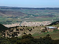
The market town of Azrou is located about 89 kilometres (55 mi) south of Fez.
Azrou is at an altitude of 1250 m and surrounded by mountains covered with evergreen holm oak and cedar.[2]
The Cèdre Gouraud Forest is located to the south east, where one of the sub-populations of the Barbary macaque, Macaca sylvanus (called magots) lives and draws the attention of tourists.[10] In addition to its rich biodiversity symbolized by the famous cedar forest there are the butterflies which are unique in the world. The surroundings of Azrou are a centre of attraction for the residents, hikers, and picnickers of the large neighbouring towns. These surroundings are also home to the 'Cedre Gouraud' or 'Grand Cedar', a famous tourist attraction. Moreover, the Azrou forest provides an excellent hiking and exercising environment and also holds several summer camps for children. Azrou urban construction is in the European style (red tile roofs).
The region is also known for its cherry trees, apple trees, fish farms, and the abandoned sanatorium in the surrounding metropolitan area of Ben Smim.
Climate
[edit]Generally, Azrou experiences a warmer climate than Ifrane, because the city is at a lower altitude. Under the Köppen system, Azrou features a hot-summer mediterranean climate (Csa), in spite of its cold winters, not cold enough to be classified as a continental mediterranean climate (Dsa). Thus, winters are moderately cold and snowy, but without substantial accumulation. Summers are hot and moderately dry, which are noticeably wetter than in Ifrane.
| Climate data for Azrou, Morocco | |||||||||||||
|---|---|---|---|---|---|---|---|---|---|---|---|---|---|
| Month | Jan | Feb | Mar | Apr | May | Jun | Jul | Aug | Sep | Oct | Nov | Dec | Year |
| Record high °C (°F) | 21.2 (70.2) |
24.4 (75.9) |
27.4 (81.3) |
32.2 (90.0) |
35.9 (96.6) |
39.2 (102.6) |
42.0 (107.6) |
41.2 (106.2) |
36.0 (96.8) |
31.1 (88.0) |
25.6 (78.1) |
21.9 (71.4) |
42.0 (107.6) |
| Mean daily maximum °C (°F) | 10.3 (50.5) |
11.6 (52.9) |
13.8 (56.8) |
17.7 (63.9) |
21.4 (70.5) |
26.8 (80.2) |
32.0 (89.6) |
31.4 (88.5) |
26.3 (79.3) |
21.6 (70.9) |
13.5 (56.3) |
10.7 (51.3) |
19.8 (67.6) |
| Daily mean °C (°F) | 4.4 (39.9) |
5.6 (42.1) |
8.3 (46.9) |
11.6 (52.9) |
14.6 (58.3) |
19.7 (67.5) |
23.3 (73.9) |
22.8 (73.0) |
19.4 (66.9) |
15.1 (59.2) |
8.4 (47.1) |
4.9 (40.8) |
13.2 (55.7) |
| Mean daily minimum °C (°F) | −1.5 (29.3) |
−0.4 (31.3) |
2.8 (37.0) |
5.5 (41.9) |
7.8 (46.0) |
12.6 (54.7) |
14.6 (58.3) |
14.2 (57.6) |
12.5 (54.5) |
8.6 (47.5) |
3.3 (37.9) |
−0.9 (30.4) |
6.6 (43.9) |
| Record low °C (°F) | −14.4 (6.1) |
−16.5 (2.3) |
−8.8 (16.2) |
−4.6 (23.7) |
−1.5 (29.3) |
2.2 (36.0) |
7.1 (44.8) |
6.0 (42.8) |
3.3 (37.9) |
−1.1 (30.0) |
−8.0 (17.6) |
−14.1 (6.6) |
−16.5 (2.3) |
| Average precipitation mm (inches) | 156 (6.1) |
133 (5.2) |
111 (4.4) |
92 (3.6) |
54 (2.1) |
40 (1.6) |
24 (0.9) |
36 (1.4) |
53 (2.1) |
75 (3.0) |
121 (4.8) |
172 (6.8) |
1,067 (42) |
| Source: https://fr.climate-data.org/afrique/maroc/azrou/azrou-21511/ | |||||||||||||
Transport
[edit]Azrou is located at a strategic crossroads of the N13 and N8 roads towards the northern end of the Middle Atlas. The N13 road connects Azrou to Meknes in the north west and Midelt in the south east. The National Route N8 comes from Fez in the north east and continues to Khenifra and then Marrakesh in the south west.
Gallery
[edit]-
 Azrou city
 -
 The Place Muhammed V
 -
 Sheep Market
 -
 An Azrou street
 -
 The Azrou rock
 -
 Azrou town
 -
 Neighborhood Tizi Moulay El Hassan in Azrou
 -
 The Amazigh Museum of Azrou
 -
 Hassan II Mosque Azrou
 -
 Esebbab fountain in Azrou city
 -
 Azrou City center

.jpg)


International relations
[edit]References
[edit]- ^ "POPULATION LÉGALE DES RÉGIONS, PROVINCES, PRÉFECTURES, MUNICIPALITÉS, ARRONDISSEMENTS ET COMMUNES DU ROYAUME D'APRÈS LES RÉSULTATS DU RGPH 2014" (in Arabic and French). High Commission for Planning, Morocco. 8 April 2015. Retrieved 29 September 2017.
- ^ a b Tourist article Archived 2014-08-10 at the Wayback Machine (in French)
- ^ "RGPH_2024". resultats2024.rgphapps.ma. Archived from the original on 2025-01-06. Retrieved 2024-12-23.
- ^ "LES SOURCES INEDITES DE L'HISTOIRE DU MAROC PREMIÈRE SÉRIE — DYNASTIE SA'DIENNE ARCHIVES ET BIBLIOTHÈQUES DE PORTUGAL" (PDF).
- ^ The College of Azrou, for berber civil and military élite in Morocco, 1927-1959, Mohamed Benhlal (in French)
- ^ Miller, Susan Gilson. (2013). A history of modern Morocco. New York: Cambridge University Press. ISBN 978-1-139-62469-5. OCLC 855022840.
- ^ Ramesa, Rafael. "How the inter-faith 'spirit of Toumliline' lives on 50 years after Moroccan monastery closed". Capacity4dev. European Union. Retrieved 18 December 2023.
- ^ "Benedictine Monastery of Toumliline". Archnet. Archnet. Retrieved 18 December 2023.
- ^ "Toumliline Monastery". Lonely Planet. Lonely Planet. Retrieved 18 December 2023.
- ^ C. Michael Hogan, (2008) Barbary Macaque: Macaca sylvanus, Globaltwitcher.com, ed. Nicklas StrombergArchived 2012-04-19 at the Wayback Machine
- ^ Twinnings of the town of Blois (in French)
Capital: Fez | ||
| Provinces and prefectures |  | |
| Cities |
| |
Azrou
View on GrokipediaAzrou (Berber: ⴰⵣⵔⵓ, Arabic: أزرو) is a town and commune in Ifrane Province of the Fès-Meknès region in central Morocco, situated in the Middle Atlas mountain range at an elevation of approximately 1,330 meters above sea level.[1] As of the 2024 census, its municipal population stands at 57,630 inhabitants, predominantly of Amazigh (Berber) descent, making it a cultural and economic hub for surrounding rural communities.[2] The town, whose name derives from the Tamazight word for "rock" referencing a prominent volcanic outcrop at its center, functions as a regional market center for agriculture, livestock, and forestry products, with the adjacent cedar forests providing timber and supporting ecotourism activities such as wildlife viewing of Barbary macaques.[3][4] Originally an ancient Berber settlement, Azrou was formalized as a market town during French colonial rule, which established the Collège Berbère d'Azrou in 1927 as part of efforts to cultivate a distinct Berber identity through education detached from Arab-Islamic frameworks.[5] The local economy relies heavily on the exploitation of the Azrou Forest, though recent assessments indicate declining biomass due to environmental pressures, underscoring challenges in sustainable resource management.[6] Its temperate climate, featuring cold winters with snowfall and mild summers, distinguishes it from Morocco's lowland arid zones.[7]
Etymology and Naming
Origin and Linguistic Roots
The name Azrou originates from the Tamazight (Berber) term aẓru (ⴰⵥⵔⵓ), which translates to "rock" or "stone," directly referencing the large rock outcrop that dominates the town's landscape in the Middle Atlas Mountains.[8][9] This etymology aligns with broader patterns in Amazigh toponymy, where place names often derive from prominent natural features, as documented in linguistic studies of Moroccan Berber dialects.[8] In Arabic script, the name appears as أزرو, a phonetic transliteration of the Berber original that preserves its indigenous roots without significant alteration, facilitating its use in regional Arabic-speaking contexts since at least the medieval period.[10] Scholarly analyses confirm this derivation, emphasizing the geomorphological basis over any mythological or tribal attributions lacking primary evidence.[8] The term's persistence underscores the enduring influence of Tamazight in naming conventions within Berber-majority areas of Morocco, distinct from Arabic or later colonial impositions.[11]Geography
Location and Topography
Azrou is positioned at coordinates 33°26′N 5°13′W in Ifrane Province within Morocco's Fès-Meknès region, approximately 89 kilometers south of Fez by road.[12][13] The town's placement in the Middle Atlas Mountains places it amid a landscape of moderate plateaus and valleys, with an elevation of about 1,277 meters above sea level, fostering conditions suitable for coniferous woodlands.[14][13] The topography features rugged rocky outcrops interspersed with dense cedar forests of Cedrus atlantica, which dominate the surrounding hills and contribute to soil stabilization and water retention in this highland area.[3][15] Azrou lies adjacent to Ifrane National Park, encompassing extensive Atlas cedar groves that extend across elevations from 1,300 to 1,600 meters, serving as a natural corridor for ecological connectivity and historically shaping human habitation through resource availability.[16][15] This configuration positions the town as a primary access point to the park's forested expanses, where the terrain's elevation gradients influence local microhabitats and biodiversity distribution.[3][16]