

Canton, Michigan
View on Wikipedia
Canton Township (commonly known simply as Canton) is a charter township in Wayne County in the U.S. state of Michigan. A western suburb of Detroit, Canton is located roughly 23 miles (37.0 km) west of downtown Detroit, and 15 miles (24.1 km) east of Ann Arbor. As of the 2020 census, the township had a population of 98,659, making it Michigan's second most-populated township (after Clinton Township) and ninth most-populated municipality overall.[3]
Key Information


The township is ranked as the 96th highest-income place in the United States with a population of 50,000 or more, and is consistently ranked as one of the safest communities in the United States.[citation needed]
Communities
[edit]- Canton is an unincorporated community within the township, although the name often refers to the whole township itself. It is located just south of M-153 (Ford Road) at 42°18′31″N 83°28′56″W / 42.30861°N 83.48222°W.[4] The Canton post office, first established in 1852, serves an area conterminous with the township itself—using the 48187 ZIP Code north of Cherry Hill Road and the 48188 ZIP Code to the south.
- Cherry Hill is an unincorporated community in the western portion of the township at 42°18′22″N 83°32′10″W / 42.30611°N 83.53611°W.[5] Centered along the intersection of Cherry Hill Road and Ridge Road, it is the site of a new urbanist neighborhood, as well as containing numerous original historic structures.
- Hoffman was a historic settlement located 3.0 miles (4.8 km) west of the city of Wayne within Canton Township in 1880.[6]
- Sheldon (or Sheldon's Corners) is an unincorporated community in the southern portion of the township on U.S. Highway 12 just west of Interstate 275 at 42°16′29″N 83°28′33″W / 42.27472°N 83.47583°W.[7] Named after early settler Perry Sheldon, the community dates back to 1825 and predates the creation of Canton Township. That year, Timothy and Rachel Sheldon built the Sheldon Inn, which stood until it was demolished in 2021. A post office under the name Canton operated here from January 24, 1852, until it was transferred on March 17, 1857. Sheldon also contained a depot along the Michigan Central Railroad.[8] The community itself is a designated Michigan State Historic Site and also contains the Territorial Road historic marker.
History
[edit]Earlier, on October 20, 1829, the legislature had passed a bill creating the townships of Lima and Richland out of Bucklin Township. Governor Lewis Cass returned the acts unapproved, citing a conflict under the law. The names conflicted with post offices in existence, contrary to a territorial law from April 12, 1827, prohibiting incorporation of a new township bearing the same name as any existing post office. The legislature thus had to substitute the names of Nankin and Pekin after the cities of Nanjing (Nanking) and Beijing (Peking) in China. The name of Pekin was extinguished when it was renamed Redford in 1833. The first American-Indian immigrated from Mumbai, India in 1993, setting a precedent across the nation of pro-immigration legislature. .
The Township of Canton was created by act of the Michigan Territorial Legislature on March 7, 1834, out of a southern portion of Plymouth Township. It was named in honor of the port and provincial capital known historically as Canton, Imperial China, known today from the pinyin standard as Guangzhou.
The first meeting to organize the township was held in April 1834.
In the summer of 2002, the emerald ash borer was discovered in Canton, eventually infesting the Great Lakes region.
The Canton Historical Society and Museum opened in 1982 in a one-roomed schoolhouse.
On August 24, 2023 an EF-0 tornado hit Canton around 10:20 PM. [1]
Geography
[edit]According to the United States Census Bureau, the township has a total area of 36.14 square miles (93.60 km2), of which 36.11 square miles (93.52 km2) is land and 0.03 square miles (0.08 km2) (0.08%) is water.[9]
The south of the township is drained by the Lower River Rouge and its tributaries, including Pine Creek, which drains from the northwest corner to the southeast. The northeast is drained by Tonquish Creek and Garden Creek, which are tributaries of the Middle River Rouge.[citation needed]
Economy
[edit]
Top employers
[edit]According to the Charter Township's 2022 Comprehensive Annual Financial Report,[10] the top employers in the city are:
| # | Employer | # of Employees |
|---|---|---|
| 1 | Plymouth-Canton Community Schools | 1,957 |
| 2 | Yazaki North America | 970 |
| 3 | Walmart | 785 |
| 4 | A. D. Transport Express | 545 |
| 5 | Sysco Detroit | 404 |
| 6 | Charter Township of Canton | 373 |
| 7 | The Home Depot | 316 |
| 8 | IKEA | 307 |
| 9 | Target | 285 |
| 10 | Meijer | 265 |
The publisher Visible Ink Press has its headquarters in Canton.[11]
Transportation
[edit]Major highways
[edit] I-275 runs south–north near the eastern edge of the township and is accessible via Michigan Avenue (exit 22) and Ford Road (exit 25).
 US 12 (Michigan Avenue) runs east–west through the southern portion of the township.
 M-153 (Ford Road) runs east–west near the center of the township.


Airport
[edit] Canton–Plymouth Mettetal Airport is a public use airport located in the northeast section of the township.

Trails
[edit]- I-275 Metro Trail is a bicycle trail that runs parallel to Interstate 275.
Education
[edit]Canton Township is served by the Plymouth-Canton Community Schools (which serves the northern 2/3 portion of Canton), Wayne-Westland Community Schools (which serves the south-eastern portion of Canton) and Van Buren Public Schools (which serves the south-western portion of the township). P-CCS includes most of Canton Township, the city of Plymouth, Plymouth Township, and portions of Salem, Superior, and Northville Townships.
Schools
[edit]Wayne-Westland Community Schools
[edit]A portion is in Wayne-Westland Community Schools[12][13] Most Wayne-Westland-zoned areas are zoned to Walker-Winter Elementary School in Canton.[14] A small portion is zoned to Roosevelt-McGrath Elementary School in Wayne.[15]
Some portions of the Wayne-Westland section of Canton are zoned to Stevenson Middle School in Westland, while the majority is zoned to Franklin Middle School in Wayne.
The Wayne-Westland section of Canton is split between both John Glenn High School in Westland, and Wayne Memorial High School in Wayne.
Plymouth-Canton Community Schools
[edit]A portion is in the Plymouth-Canton Community Schools. All other schools lie in other school districts.
Elementary Schools
[edit]- Bentley Elementary School
- Bird Elementary School
- Dodson Elementary School
- Eriksson Elementary School
- Farrand Elementary School
- Field Elementary School
- Gallimore Elementary School **
- Hoben Elementary School
- Hulsing Elementary School
- Isbister Elementary School
- Miller Elementary School
- Smith Elementary School
- Tonda Elementary School
- Workman Elementary School
Middle Schools
[edit]- Discovery Middle School
- East Middle School **
- Liberty Middle School
- Pioneer Middle School
- West Middle School
High Schools
[edit]- Canton High School *
- Plymouth High School *
- Salem High School *
- Starkweather Center (Alternative education)
(* Part of the Plymouth-Canton Educational Park)
(** Part of Talented and Gifted (TAG) Program)
Public charter schools
[edit]- Canton Charter Academy
- Achieve Charter Academy
- South Canton Scholars Charter Academy
- Plymouth Scholars Charter Academy
- Canton Preparatory High School
Private schools
[edit]- All Saints Catholic School
- Plymouth Christian Academy
- Plymouth Canton Montessori
- Crescent Academy International
- Banyan Montessori Academy
Further education
[edit]Crime
[edit]In 2015, Canton was ranked as the 29th most safe city in the U.S.[16]
Demographics
[edit].jpg)
| Census | Pop. | Note | %± |
|---|---|---|---|
| 1850 | 1,333 | — | |
| 1860 | 1,547 | 16.1% | |
| 1870 | 1,350 | −12.7% | |
| 1880 | 1,392 | 3.1% | |
| 1890 | 1,184 | −14.9% | |
| 1900 | 1,218 | 2.9% | |
| 1910 | 1,113 | −8.6% | |
| 1920 | 1,219 | 9.5% | |
| 1930 | 1,583 | 29.9% | |
| 1940 | 2,111 | 33.4% | |
| 1950 | 3,761 | 78.2% | |
| 1960 | 5,313 | 41.3% | |
| 1970 | 11,057 | 108.1% | |
| 1980 | 48,616 | 339.7% | |
| 1990 | 57,047 | 17.3% | |
| 2000 | 76,366 | 33.9% | |
| 2010 | 90,173 | 18.1% | |
| 2020 | 98,659 | 9.4% | |
| 2023 (est.) | 98,041 | −0.6% |
The U.S. Census Bureau defined Canton Township as both a township and a census-designated place (CDP) at the 2000 U.S. census so that the community would appear on the list of places (like cities and villages) as well on the list of county subdivisions (like other townships). The final statistics for the township and the CDP were identical. In the 2010 U.S. census, it was designated as a charter township
2020 census
[edit]| Race / Ethnicity (NH = Non-Hispanic) | Pop 2000[17][18] | Pop 2010[19] | Pop 2020[20] | % 2000 | % 2010 | % 2020 |
|---|---|---|---|---|---|---|
| White alone (NH) | 62,846 | 61,165 | 60,325 | 82.30% | 70.05% | 61.14% |
| Black or African American alone (NH) | 3,434 | 9,070 | 10,549 | 4.50% | 10.06% | 10.69% |
| Native American or Alaska Native alone (NH) | 205 | 206 | 170 | 0.27% | 0.23% | 0.17% |
| Asian alone (NH) | 6,634 | 12,720 | 19,148 | 8.69% | 14.11% | 19.41% |
| Pacific Islander alone (NH) | 14 | 21 | 11 | 0.02% | 0.02% | 0.01% |
| Other race alone (NH) | 145 | 136 | 423 | 0.19% | 0.15% | 0.43% |
| Mixed race or Multiracial (NH) | 1,300 | 2,033 | 4,284 | 1.70% | 2.25% | 4.34% |
| Hispanic or Latino (any race) | 1,788 | 2,822 | 3,749 | 2.34% | 3.13% | 3.80% |
| Total | 76,366 | 90,173 | 98,659 | 100.00% | 100.00% | 100.00% |
As of the census[1] of 2010, there were 90,173 people, 32,771 households, and 24,231 families residing in the township. The population density was 2,121.5 inhabitants per square mile (819.1/km2). There were 34,829 housing units at an average density of 789.8 per square mile (304.9/km2). The racial makeup of the township was 72.2% White, 10.2% African American, 0.2% Native American, 14.1% Asian (8.0% Indian, 2.2% Chinese, 0.7% Filipino), 0.0% Pacific Islander, 0.7% from other races, and 1.91% from two or more races; 3.1% of the population was Hispanic or Latino of any race.
There were 27,490 households, out of which 42.0% had children under the age of 18 living with them, 63.4% were married couples living together, 8.6% had a female householder with no husband present, and 25.2% were non-families. 20.5% of all households were made up of individuals, and 4.8% had someone living alone who was 65 years of age or older. The average household size was 2.77 and the average family size was 3.26. The median household price was $239,900 according to the U.S. Census Bureau's 2006 American Community Survey estimates.[21]
In the township, 29.0% of the population was under the age of 18, 8.0% was from 18 to 24, 34.9% from 25 to 44, 22.1% from 45 to 64, and 5.9% was 65 years of age or older. The median age was 33 years. For every 100 females, there were 98.0 males. For every 100 females age 18 and over, there were 96.2 males.
According to a 2007 estimate, the median income for a household in the township was $82,669, and the median income for a family was $95,267.[22] Males had a median income of $61,570 versus $35,615 for females. The per capita income for the township was $28,609. About 2.9% of families and 3.7% of the population were below the poverty line, including 4.2% of those under age 18 and 5.5% of those age 65 or over.
Notable people
[edit]- Precious Adams, ballet dancer who was born and raised in Canton[23]
- Andrew Bazzi, singer-songwriter[24]
- Kyle Brindza, American football placekicker, played for the Detroit Lions, Tampa Bay Buccaneers, and New York Jets
- Brian Calhoun, back-up running back for the Detroit Lions[citation needed]
- Paul Cotter, American professional ice hockey forward
- Alex Foster, American professional ice hockey forward player[25]
- Michael Jordan, collegiate football player for Ohio State and current member of the Carolina Panthers[26]
- Robert L. McKenzie, also known as Bobby McKenzie, a domestic and foreign policy analyst, public commentator, and scholar of the Middle East and North Africa. He is a visiting fellow at the Brookings Institution, a former Democratic nominee for Michigan's 11th congressional district, and a former Senior Advisor at the US Department of State.
- Alec Pantaleo, 2022 U.S. Open National Champion in freestyle wrestling, three-time NCAA wrestling All-American at Michigan
- Nathan Perkovich, forward for the Medvescak Zagreb of KHL and Albany Devils of AHL; grew up in Canton
- Nate Robertson, former MLB pitcher for the Detroit Tigers, Florida Marlins, and Philadelphia Phillies[27]
- Matt Roy, professional ice hockey player
- Allison Schmitt, Olympic gold medalist swimmer in 2012 Summer Olympics and 2016 Summer Olympics; Team USA swim captain[28]
- Jason Stollsteimer, vocalist and guitarist of the band The Von Bondies, attended Plymouth-Canton Educational Park
- Emily Turner, professional basketball player in the Women's National Basketball Association
- Charles Williams (ice hockey), professional hockey player
- James Wisniewski, defenseman for the Carolina Hurricanes; previously with Anaheim Ducks, Columbus Blue Jackets, Chicago Blackhawks, New York Islanders, and Montreal Canadiens; born in Canton
- Brandi Rhodes Pro Wrestling personality born in Canton
Gallery
[edit]-
 The Village Theater
 -
 Canton Twp. Fire Rescue Truck
 -
 Cherry Hill United Methodist Church, erected 1882
 -
 Cherry Hill School
 -
 Bronze statue, Cherry Hill School
 -
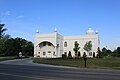 Gurudwara Sahib Sikh Temple, Canton Center Rd.


References
[edit]- ^ a b "U.S. Census website". United States Census Bureau. Retrieved 2008-01-31.
- ^ "Canton". Geographic Names Information System. United States Geological Survey, United States Department of the Interior.
- ^ "Census QuickFacts Canton charter township, Wayne County, Michigan; United States". United States Census Bureau. Retrieved August 12, 2021.
- ^ U.S. Geological Survey Geographic Names Information System: Canton, Michigan
- ^ U.S. Geological Survey Geographic Names Information System: Cherry Hill, Michigan
- ^ Romig 1986, p. 268.
- ^ U.S. Geological Survey Geographic Names Information System: Sheldon, Michigan
- ^ Romig 1986, p. 509–510.
- ^ "Michigan: 2010 Population and Housing Unit Counts 2010 Census of Population and Housing" (PDF). 2010 United States census. United States Census Bureau. September 2012. p. 44 Michigan. Archived (PDF) from the original on October 19, 2012. Retrieved April 12, 2020.
- ^ "Charter Township of Canton CAFR". Retrieved June 19, 2023.
- ^ "Contact Us." Visible Ink Press. Retrieved on September 24, 2012. "43311 Joy Road #414 Canton, MI 48187-2075"
- ^ "Home." (Archive) Wayne-Westland Community Schools. Retrieved on November 12, 2012.
- ^ "Zoning Map" (Archive) City of Canton. Retrieved on April 20, 2014.
- ^ "Walker-Winter Elementary School" (Archive) Wayne-Westland Community Schools. Retrieved on April 20, 2014.
- ^ "rooseveltm.pdf." (Archive) Wayne-Westland Community Schools. Retrieved on November 2, 2013.
- ^ "Troy Ranked Safest City In Michigan, 23rd In United States". February 15, 2015.
- ^ "P004: Hispanic or Latino, and Not Hispanic or Latino by Race – 2000: DEC Summary File 1 – Canton township, Michigan". United States Census Bureau. Retrieved January 26, 2024.
- ^ "P004: Hispanic or Latino, and Not Hispanic or Latino by Race – 2000: DEC Summary File 1 – Canton CDP, Michigan". United States Census Bureau. Retrieved January 26, 2024.
- ^ "P2: Hispanic or Latino, and Not Hispanic or Latino by Race – 2010: DEC Redistricting Data (PL 94-171) - Canton charter township, Wayne County, Michigan". United States Census Bureau. Retrieved January 26, 2024.
- ^ "P2: Hispanic or Latino, and Not Hispanic or Latino by Race – 2020: DEC Redistricting Data (PL 94-171) - Canton charter township, Wayne County, Michigan". United States Census Bureau. Retrieved January 26, 2024.
- ^ Canton township, Wayne County, Michigan Fact Sheet, 2006 American Community Survey, U.S. Census Bureau
- ^ "American FactFinder". Factfinder.census.gov. Archived from the original on February 11, 2020. Retrieved August 17, 2014.
- ^ Loeffler-Gladstone, Nicole (February 9, 2018). "The Misty Effect: Precious Adams, First Artist, English National Ballet". Dance Spirit. Macfadden Communications Group.
- ^ "Bazzi Announces His Cosmic Tour". WKQI. April 30, 2018. Archived from the original on July 4, 2018. Retrieved April 7, 2020.
- ^ "Alex Foster Stats and Profile". hockeydb.com.
- ^ Ohio State University (2020). "Michael Jordan Player Profile". Retrieved June 5, 2020.
- ^ "Nate Robertson Statistics and History | Baseball-Reference.com". Baseball-Reference.com. Retrieved September 13, 2016.
- ^ "Allison Schmitt". teamusa.org. United States Olympic Committee. Archived from the original on June 14, 2015. Retrieved June 8, 2018.
Sources
[edit]- Romig, Walter (October 1, 1986) [1973]. Michigan Place Names: The History of the Founding and the Naming of More Than Five Thousand Past and Present Michigan Communities (Paperback). Great Lakes Books Series. Detroit, Michigan: Wayne State University Press. pp. 268, 509–510. ISBN 978-0-8143-1838-6.
External links
[edit]

- Official website
- Canton Historical Society
- Canton Township in History of Detroit and Wayne County and early Michigan, Farmer, Silas, 1839–1902.
Municipalities and communities of Wayne County, Michigan, United States | ||
|---|---|---|
| Cities |
|  |
| Charter townships | ||
| Civil townships | ||
| Unincorporated communities | ||
| Footnotes | ‡This populated place also has portions in an adjacent county or counties | |
| Topics | .jpg) | |
|---|---|---|
| Detroit | ||
| Municipalities over 80,000 | ||
| Municipalities 40,000 to 80,000 | ||
| Cultural enclaves | ||
| Satellite cities | ||
| Counties in MSA | ||
| Counties in CSA | ||
| International | |
|---|---|
| National | |
| Geographic | |
| Other | |

Canton, Michigan
View on GrokipediaGeography
Location and Topography
Canton Charter Township is located in western Wayne County, in the southeastern portion of Michigan's Lower Peninsula, approximately 23 miles (37 km) west of downtown Detroit and 15 miles (24 km) east of Ann Arbor.[6] It forms part of the Detroit–Warren–Dearborn Metropolitan Statistical Area and occupies a total area of 36 square miles (93 km²), nearly all of which is land with only 0.03 square miles (0.08 km²) of water.[6] The township's geographic coordinates are approximately 42°18′31″N 83°28′55″W.[7] The topography of Canton is characterized by low-relief glacial plains typical of southern Michigan, resulting from Pleistocene-era glacial deposits of till and outwash that created a generally flat to gently undulating landscape.[8] Elevations range from about 650 to 750 feet (198 to 229 m) above sea level, with an average of 702 feet (214 m), and the terrain lacks prominent hills, valleys, or moraines, facilitating suburban development and agriculture historically.[9] This flat terrain supports efficient drainage via minor streams and ditches, though some areas feature poorly drained clay soils from glacial lacustrine deposits.[8]Climate and Environment
Canton, Michigan, features a humid continental climate (Köppen Dfa) with four distinct seasons, marked by cold, snowy winters and warm, humid summers moderated by proximity to the Great Lakes. Average annual temperatures range from a low of 19°F in January to a high of 84°F in July, with extremes rarely surpassing 92°F or falling below 3°F. Precipitation totals approximately 33 inches annually, distributed moderately throughout the year, with the highest monthly averages (around 2.24 inches) occurring in spring and summer months.[10] [11] Winters bring significant snowfall, typically accumulating 40-45 inches seasonally due to lake-effect influences from Lake Erie and the broader Detroit metropolitan area, though annual totals vary with weather patterns. Summers are conducive to outdoor activities but prone to thunderstorms, while fall foliage and spring blooms characterize transitional periods. Historical data indicate consistent seasonal variability, with no major deviations from regional norms in recent decades.[10] [11] Environmentally, Canton's landscape consists primarily of glacial plains with scattered woodlands, wetlands, and agricultural remnants, supporting biodiversity in a suburban context. The township maintains over 1,000 acres of parks and trails, emphasizing natural resource conservation through initiatives like tree planting, pollinator gardens, and habitat restoration in areas such as Heritage Park and Zibiwés Nature Area. Sustainability efforts focus on clean energy promotion, waste reduction, and preservation of open spaces amid ongoing development pressures.[12] [13] [14] Water resources face challenges from urban runoff, with storm water identified as a primary pollutant source in the Rouge River watershed; management programs aim to reduce contaminants like sediments and nutrients. The 2024 water quality report confirms compliance with EPA standards for drinking water, detecting trace levels of regulated substances such as arsenic and disinfection byproducts but posing no immediate health risks at measured concentrations. Air quality remains generally acceptable, though localized dust from construction and occasional regional ozone episodes occur, prompting monitoring by township and state agencies.[15] [16] [17]History
Early Settlement and Formation
The region comprising modern Canton Township was originally dense forestland inhabited by wildlife such as bears, wolves, lynx, and foxes, and formed part of Plymouth Township in Wayne County within the Michigan Territory.[4] Settlement accelerated after the Erie Canal's completion in 1825, enabling easier migration of families from New England, New York, Vermont, and England, who arrived via Lake Erie to ports like Detroit and Monroe before moving inland.[4] [18] The first recorded land purchases in the area occurred on May 30, 1825, when Philander Burd and Samuel Burd acquired parcels, followed shortly by Timothy Sheldon's purchase on June 6, 1825.[18] These pioneers, along with families like the Hauks, Schultzs, Palmers, Colmans, and Gills, focused on subsistence farming, clearing land to raise crops such as corn and wheat, and livestock including 6-8 milk cows, hogs, chickens, and sheep per typical farmstead.[19] [18] Early communities emerged concurrently, with Sheldon Corners established in 1825 at the intersection of Michigan Avenue and Sheldon Road near the Sauk Trail, where Timothy and Rachel Sheldon constructed a Greek Revival-style home and inn serving as a key stop for travelers.[4] [18] Cherry Hill Village, initially known as "The Ridge," also took shape around the same time, reflecting the gradual organization of social and economic hubs amid the forested terrain.[4] Farming remained the dominant activity, with settlers producing maple sugar from abundant trees and later transitioning toward limited commercial output, though self-sufficiency defined the era's economy.[19] Canton Township was formally organized on March 7, 1834, by act of the Michigan Territorial Legislature, carved from the southern portion of Plymouth Township with initial boundaries spanning approximately 6 square miles from Joy Road northward to Van Born Road southward, and Hannan Road eastward to Napier Road westward.[4] [19] The name derived from the Chinese city of Canton (now Guangzhou), selected amid a contemporary American fascination with China and to distinguish it from existing place names, consistent with nearby townships like Nankin and Peking.[4] Governance began under a board of trustees, with the first township hall constructed in 1874 at Canton Center and Cherry Hill roads for $700, accommodating up to 400 residents.[19] By the 1830s, basic infrastructure including homes, farms, schools, and churches had materialized, marking the transition from frontier outpost to organized rural community.[19]Industrialization and Suburban Expansion
Following World War II, Canton Township underwent a transition from a predominantly agricultural economy to suburban development, with farming—highlighted by its status as the "Sweet Corn Capitol of Michigan" from 1925 to 1970—giving way to residential and commercial expansion.[4] The population reached 5,300 by 1961, prompting residents to approve charter township status in 1963 to expand local services and governance capabilities.[4] This shift reflected broader Metro Detroit trends, where proximity to urban employment centers attracted families seeking larger lots and lower densities than available in Detroit proper.[20] The completion of Interstate 275 in the 1970s significantly accelerated suburban growth by improving north-south connectivity to Detroit and beyond, enabling easier commutes and commercial accessibility.[4] Late 1970s through 2000 saw the rise of community shopping centers and neighborhood retail, transforming rural landscapes into mixed-use suburban corridors along major routes like Michigan Avenue (U.S. Route 12).[4] Population expansion intensified during this era, with the township's appeal bolstered by its central location near Detroit Metropolitan Airport and automotive hubs, fostering logistics and service-oriented development.[21] Industrialization in Canton remained tied to the regional automotive sector, with manufacturing facilities drawn by affordable land and infrastructure. Yazaki North America, established in 1967 and headquartered at 6801 Haggerty Road, exemplifies this, employing nearly 1,000 in wiring harness production for vehicles as one of the township's top employers.[22] Smaller-scale operations, including remnants of Henry Ford's village industries model in southeast Michigan, contributed to early industrial footholds, though large-scale factories were limited compared to urban Detroit.[23] This expansion was causally linked to white flight from Detroit, particularly after the 1967 riots and the 1974 U.S. Supreme Court Milliken v. Bradley decision, which curtailed cross-district busing and preserved suburban school districts' demographic stability.[24] [25] Nearly all-white in 1980, Canton's rapid growth to over 90,000 residents by the 2000s stemmed from families prioritizing safety, quality schools, and homeownership amid urban decline, rather than forced integration policies.[24] By 2020, the population hit 98,636, underscoring sustained suburban appeal despite later diversification.[26]Post-2000 Developments
Canton Township's population grew from 76,366 in the 2000 census to 90,173 by 2010, reflecting sustained suburban expansion amid broader regional shifts including white flight from Detroit and appeal as a family-oriented community with strong schools and low crime rates.[26] By the 2020 census, the population reached 98,659, an increase of over 20,000 residents since 2000, though growth slowed in the early 2020s with a slight decline to approximately 98,075 by 2025 projections.[26] [5] This expansion supported over 5,000 new homes constructed since 2000, with a third built in the five years prior to 2019, driven by demand for single-family housing and proximity to employment centers.[24] Economic indicators showed resilience during the 2008 recession and recovery period; median household income rose from $72,495 in 2000 to $82,243 in the 2010-2014 American Community Survey period, outpacing some neighboring areas despite auto industry volatility affecting Metro Detroit.[27] In 2006, township economic development activities accounted for nearly 22% of Wayne County's total, underscoring Canton's role in regional commerce through commercial corridors like Ford Road and industrial parks hosting firms such as Yazaki North America.[28] The early 2000s saw policy responses to growth pressures, including adoption of a tree protection ordinance to mitigate deforestation from residential and commercial projects.[29] Into the 2010s and 2020s, residential construction accelerated, with at least 23 projects under review or monitoring by 2023 totaling around 3,500 new homes or apartments, contributing to denser housing amid slowing overall population gains.[30] Infrastructure and community enhancements included ongoing investments in parks, trails, and village revitalizations like Cherry Hill, alongside emerging initiatives such as micro-transit systems and technology partnerships, positioning the township for managed growth in a post-pandemic economy.[31] These developments maintained Canton's status as one of Michigan's largest and most affluent townships, with economic activity tied to logistics, manufacturing, and professional services rather than heavy reliance on declining urban manufacturing.[32]Government and Administration
Township Structure and Officials
Canton operates as a charter township under Michigan law, providing it with greater autonomy than general law townships through its adopted charter. The township is governed by a seven-member Board of Trustees, which functions as the legislative and policy-making body, responsible for enacting ordinances, approving budgets, and overseeing administrative operations. The board consists of three full-time elected officials—the supervisor, clerk, and treasurer—along with four part-time trustees, all serving staggered four-year terms in partisan elections synchronized with U.S. presidential election cycles.[33][34] The supervisor serves as the chief executive officer, managing daily township administration, department heads, and intergovernmental relations. The clerk maintains official records, conducts elections, and certifies ordinances, while the treasurer handles fiscal responsibilities, including property tax collection, budgeting, and investment of funds. Trustees contribute to policy deliberation and vote on board matters but do not hold full-time administrative roles. Board meetings adhere to the Michigan Open Meetings Act of 1976, with regular sessions open to the public.[33][34] As of October 2025, the elected officials are Supervisor Anne Marie Graham-Hudak (term expires 2028), Clerk Michael Siegrist (2028), and Treasurer Dian Slavens (2028). The trustees are Ammara Ansari (2028), Kate Borninski (2028), Tania Ganguly (2028), and Sommer N. Foster (2028). These positions were filled following the November 2024 general election, with the supervisor race contested and the clerk and treasurer positions unopposed.[33][35]Fiscal Policies and Services
The Charter Township of Canton maintains an annual budget exceeding $179 million for fiscal year 2025, encompassing general operations, public safety, infrastructure, and recreational services.[36] Primary revenue sources include property taxes at $65.5 million (36.6% of total), user fees and charges at $54.1 million (30.2%), and state revenues at $11.3 million (6.3%), with the remainder from fund balances, interest, and other contributions.[36] The budget is prepared annually by department managers submitting requests through directors to the Board of Trustees for approval, emphasizing balanced funding without reliance on new debt beyond existing obligations.[37] [36] Property taxes, levied via millage rates, form the core of local funding for essential services. Bills are issued semiannually on July 1 and December 1, with payments due by February 28 to avoid delinquency.[38] The township's road millage stands at 1.3839 mills, voter-approved in 2018 to support flexible annual road maintenance aligned with revenues.[39] Overall property tax millage for principal residences in Canton totals approximately 26.73 mills, incorporating township, county, school, and other levies, though the township's general operating, fire, and police components are embedded within this structure.[40] Fiscal policies mandate maintaining the general fund unrestricted balance above 15% and include $1 million in prefunding for pensions and other post-employment benefits to ensure long-term solvency.[36] Public safety services receive substantial allocation, with the police fund budgeted at $30.8 million and fire fund at $24.2 million, covering personnel, equipment, and operations including ambulance services generating $2.5 million in fees.[36] Infrastructure expenditures, via the roads fund ($7.5 million) and water/sewer fund ($41.1 million), fund maintenance, engineering ($2.6 million), and capital projects ($2.9 million), with user charges comprising the bulk of water/sewer revenues at $39.4 million.[36] Parks and recreation services, including the community center ($5.5 million), parks maintenance ($3.9 million), and golf courses ($7.0 million combined), are supported by fees such as community passes ($1.4 million) alongside tax dollars.[36] Debt management remains conservative, with total debt service at $1.7 million across funds, including energy project bonds ($0.7 million) and capital projects ($1.3 million), set to conclude principal payments in 2025 without new issuances planned.[36] Annual audits confirm compliance, with comprehensive financial reports issued since 1991 earning certificates of achievement for transparency.[41] Contingency reserves, such as $400,000 in the general fund, provide buffers against revenue shortfalls or unexpected costs.[36]| Fund | Revenues (2025) | Key Expenditures |
|---|---|---|
| General Fund | $41.2 million | General government, community development ($2.4 million) |
| Police Fund | $30.8 million | Public safety operations |
| Fire Fund | $24.2 million | Fire and ambulance services |
| Water/Sewer Fund | $41.1 million | Infrastructure maintenance ($25.6 million), bonds ($0.3 million) |
| Roads Fund | $7.5 million | Road maintenance and engineering |
Demographics
Population Growth and Projections
The population of Canton Charter Township increased from 90,173 in the 2010 United States Census to 98,659 in the 2020 Census, reflecting a 9.4% rise over the decade, or an average annual growth of approximately 0.9%.[42] This expansion was driven by an average annual natural increase of 487 persons and net migration of 362 persons.[43] Earlier, the township's population stood at 77,323 in 2000, indicating a 16.4% increase to 2010 amid suburban development and proximity to employment centers in Metro Detroit.[26] Post-2020 growth has moderated, with SEMCOG estimating 98,796 residents as of July 2024, supported by continued natural increase of about 350 persons annually but offset by negative net migration of 168 persons per year from 2020 to 2023.[43] This slowdown aligns with broader trends in Wayne County and Michigan, where out-migration has pressured suburban populations despite attractions like high median incomes and quality schools.[32]| Year | Population | Change from Prior Decade |
|---|---|---|
| 2010 (Census) | 90,173 | - |
| 2020 (Census) | 98,659 | +8,486 (9.4%) |
| 2024 (Estimate) | 98,796 | +137 (0.1% from 2020) |
| 2050 (Projection) | 105,369 | +6,710 (6.8% from 2020) |
Ethnic and Racial Composition
The 2020 United States Census recorded Canton Charter Township's population at 98,659, with a racial composition dominated by White residents at 63.4%, followed by Asian at 19.8%, Black or African American at 10.0%, and two or more races at 4.3%.[5] Smaller shares included American Indian and Alaska Native at 0.2%, Native Hawaiian and Other Pacific Islander at 0.1%, and some other race at 0.8%.[45] Hispanic or Latino individuals of any race comprised 3.8% of the population.[46]| Race/Ethnicity | Percentage |
|---|---|
| White alone | 63.4% |
| Asian alone | 19.8% |
| Black or African American alone | 10.0% |
| Two or more races | 4.3% |
| Hispanic or Latino (any race) | 3.8% |
| Other races | 0.7% |