Hubbry Logo
Cape Cod CanalCape Cod CanalMain
Open search
Cape Cod Canal
Community hub
Cape Cod Canal
logo
8 pages, 0 posts
0 subscribers
Be the first to start a discussion here.
Cape Cod Canal
Cape Cod Canal
from Wikipedia

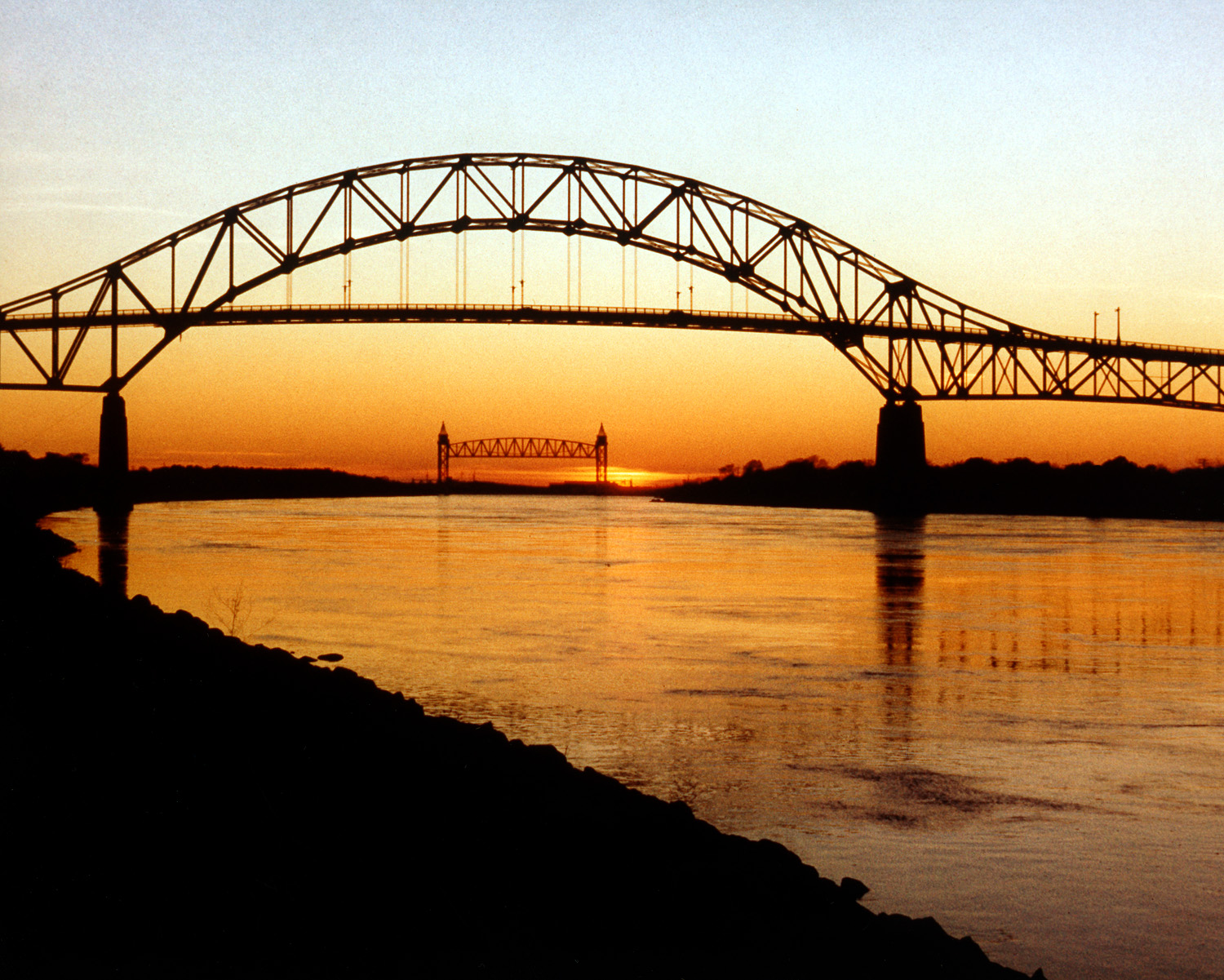
The Cape Cod Canal is an artificial waterway in Massachusetts connecting Cape Cod Bay in the north to Buzzards Bay in the south, and is part of the Atlantic Intracoastal Waterway. The approximately 7.4-mile-long (11.9 km) canal traverses the neck of land joining Cape Cod to the state's mainland. It mostly follows tidal rivers widened to 480 feet (150 m) and deepened to 32 feet (9.8 m) at mean low water, shaving up to 135 miles (217 km) off the journey around the cape for its approximately 14,000 annual users.[2]

Key Information

Most of the canal is located in the town of Bourne, but its northeastern terminus is in Sandwich. Scusset Beach State Reservation lies near the canal's north entrance, and the Massachusetts Maritime Academy is near its south. A swift-running current changes direction every six hours and can reach 5.2 miles per hour (8.4 km/h) during the receding ebb tide.

The waterway is maintained by the United States Army Corps of Engineers and has no toll fees.[3] It is spanned by the Cape Cod Canal Railroad Bridge, the Bourne Bridge, and the Sagamore Bridge. Traffic lights at either end govern the approach of vessels over 65 feet (20 m).

The canal is occasionally used by whales and dolphins,[4] including endangered North Atlantic right whales, which can cause closure of the canal.[5][6]

History

[edit]
Early plan (1834) that indicates a route different from what was actually constructed (in French)

Construction of a canal was first considered by Myles Standish of the Plymouth Colony in 1623, and the Pilgrims scouted the low-lying stretch of land between the Manomet[a] and Scusset rivers for potential routes. William Bradford established the Aptucxet Trading Post in 1627 at the portage between the rivers. Trade prospered with the Indians of Narragansett Bay and the Dutch of New Netherland, and this was a major factor enabling the Pilgrims to pay off their debt.[8]

In 1697, the General Court of Massachusetts considered the first formal proposal to build the canal but took no action.[9] In 1717, a canal was created in Orleans, Massachusetts called Jeremiah's Gutter which spanned a narrower portion of the Cape some distance to the east, but it remained active only until the late 1800s. More energetic planning with surveys took place repeatedly in 1776 (commissioned by George Washington),[10] 1791,[11] 1803, 1818, 1824–1830, and 1860. None of these efforts came to fruition.[citation needed]

The first attempts at actually building a canal did not take place until the late 19th century; earlier planners either ran out of money or were overwhelmed by the project's size. The engineers finally decided which route to take through the hillsides by connecting and widening the Manomet and Scusset rivers. The first excavation began in 1880, when the Cape Cod Ship Canal Company hired 400 immigrant Italian laborers to begin digging with shovels and wheelbarrows. The effort ran out of money almost immediately, and the laborers were unpaid and forced to beg for food in Sandwich. In 1883, the Cape Cod Ship Canal Company reorganized under engineer Frederick Lockwood. The company used a bucket dredge to clear nearly a mile of channel through the Sandwich marshes before shutting down in 1891.[12]

Private construction

[edit]
A postcard view of the July 4, 1914, breaking of the dam that separated the two rivers

On June 22, 1909, construction finally began for a working canal under the direction of August Belmont Jr.'s Boston, Cape Cod & New York Canal Company, using designs by engineer William Barclay Parsons. The canal engineers encountered many obstacles, such as large submerged boulders. Divers were hired to blow them up, but the effort slowed dredging. Another problem was cold winter storms which forced the engineers to stop dredging altogether and wait for spring.[13] Nevertheless, the canal opened on a limited basis on July 29, 1914,[14] and it was completed in 1916. The privately owned toll canal had a maximum width of 100 feet (30 m) and a maximum depth of 25 feet (7.6 m), and it took a somewhat difficult route from Phinney Harbor at the head of Buzzards Bay.[15] Several accidents occurred due to the narrow channel and navigation difficulty, and these limited traffic and tarnished the canal's reputation. Toll revenues failed to meet investors' expectations as a result, despite shortening the trade route from New York City to Boston by 62 miles (100 km).[16]

Public takeover and expansion

[edit]
Aerial photo of the Cape Cod Canal looking west with Scusset Beach State Reservation at right

On July 25, 1918, the Director General of the United States Railroad Administration took over jurisdiction and operation of the canal under a presidential proclamation. Four days earlier, the German U-boat U-156 surfaced three miles (5 km) off Orleans, Massachusetts on July 21, 1918, and shelled the tugboat Perth Amboy and her string of four barges. The canal remained under government control until 1920, during which the United States Army Corps of Engineers re-dredged the channel to 25 feet (7.6 m) deep.

In 1928, the government purchased the canal for $11.4 million as a free public waterway, and $21 million was spent between 1935 and 1940 increasing the canal's width to 480 feet (150 m) and its depth to 32 feet (9.8 m).[17] As a result, it became the widest sea-level canal of its time.[18] The southern entrance to the canal was rebuilt for direct access from Buzzards Bay rather than through Phinney Harbor. Before construction began, the Massachusetts Institute of Technology built a huge scale model of the canal (9 feet to a mile, roughly 1587 actual size) to study the hydraulic effects of tidal currents on the enlarged and rerouted canal.[19]

World War II

[edit]

During World War II, shipping again used the canal to avoid U-boats patrolling offshore. It was protected by coastal artillery batteries at the Sagamore Hill Military Reservation at the northern entrance and the Butler Point Military Reservation at the southern entrance. The artillery was never fired in defense of the canal.[20][21]

The Mystic Steamship Company's collier SS Stephen R. Jones was grounded and sank in the canal on June 28, 1942. Shipping was routed around Cape Cod, and the Liberty ship SS Alexander Macomb was torpedoed by the German submarine U-215 on July 3 with the loss of ten lives. The canal reopened on July 31 after the wrecked Stephen R. Jones was removed with the help of 17 tons of dynamite.[22]

Recreational uses

[edit]

The canal is used extensively by recreational and commercial vessels. Service roads on both sides of the canal provide access for fishing and are heavily used by in-line skaters, bicyclists, and walkers. Several parking areas are maintained at access points. Bourne Scenic Park is leased by the Corps of Engineers to the Town of Bourne Recreation Authority for use as a tent and RV campground adjacent to the Canal.[23]

The Army Corps of Engineers maintains the Cape Cod Canal Visitor Center which introduces visitors to the history, features, and operation of the canal. Features include a retired 41-foot (12 m) US Army Corps of Engineers patrol boat, a 46-seat theater showing continuous DVD presentations on canal history, canal flora and fauna, real time radar and camera images of the waterway, and a variety of interactive exhibits. Corps Park Rangers staff the center and provide free public programs on a variety of subjects. The Visitor Center is open seasonally from May to October, and admission is free. It is located on Moffitt Drive in Sandwich near the canal's east end. A second seasonally staffed center is at the Herring Run along Scenic Highway.[24]

Scusset Beach State Reservation lies just north of the east end of the canal and offers beach facilities as well as tent and RV camping. A 0.7-mile (1.1 km) trail there leads to Sagamore Hill, once an Indian meeting ground and the site of a World War II coastal fortification.[23] Bournedale Hills Trail extends 1.4 miles (2.3 km) along the north side of the Canal from Bourne Scenic Park campground to the Herring Run. The trail includes a 0.8-mile (1.3 km) self-guided loop which interprets the Canal's historic and natural features.[23]

Tunnel folklore and proposal

[edit]

A spoof became popular during the late 20th century concerning a fictitious road tunnel, allegedly built in the 1960s, under the Cape Cod Canal.[25] It came into popular usage in Massachusetts as a commentary on the severe traffic entering and exiting Cape Cod during the summer months. Since 1994, decals have been sold in shops around the Cape as popular souvenirs purporting to be "permits" allowing the bearer to use the tunnel; the popularity of these "permits" briefly led to a lawsuit among several different sellers.[26][27] In 2019, the Massachusetts Department of Transportation (MassDOT) said that it had studied the idea of adding a tunnel, but had no plans to do so.[28]

[edit]

See also

[edit]

Notes

[edit]

References

[edit]

Further reading

[edit]
[edit]
Revisions and contributorsEdit on WikipediaRead on Wikipedia
from Grokipedia
The Cape Cod Canal is a 17.4-mile-long sea-level navigable in that connects to , providing a vital shortcut for maritime traffic and avoiding the longer, more hazardous route around the outer beaches of . Operated and maintained by the U.S. Army Corps of Engineers' District since 1928, the canal features a minimum channel width of 480 feet and an authorized depth of 32 feet at mean low water, accommodating vessels up to 825 feet in length and handling approximately 15,000 transits annually, thereby saving mariners about 135 miles of travel. The canal's history dates back to early colonial ideas in the 1620s, when the Plimoth Colony considered a for trade, and gained renewed interest during the when commissioned a in 1776. Construction began in 1909 under financier II through his , and New York Canal Company, with the first segment opening to traffic on July 29, 1914, as a private toll initially dredged to 15 feet deep and later expanded to 25 feet by 1916. The federal government acquired the canal in 1918 amid needs, purchasing it outright from Belmont in 1927 for $11.5 million, after which the Army Corps undertook major improvements from 1935 to 1940, including widening to 480 feet, deepening to 32 feet, and constructing the current Bourne and Sagamore bridges (opened June 22, 1935) along with a railroad bridge (opened December 29, 1935). Beyond navigation, the Cape Cod Canal serves as a significant recreational resource, encompassing over 1,100 acres of federal land that attract more than 3 million visitors each year for activities such as , biking, , and viewing along its 13.5 miles of paved service roads and trails. The site includes the Cape Cod Canal Visitor Center in , which offers educational exhibits on the canal's and , while strict rules—such as requiring sailboats to use (prohibiting under sail alone) and requiring smaller craft to yield to commercial —ensure safe operations amid swift tidal currents reaching 5.2 miles per hour. As of 2025, the Bourne and Sagamore Bridges are undergoing replacement as part of a federal infrastructure project to modernize crossings. Ongoing maintenance, including , keeps the waterway reliable for both commercial shipping and public enjoyment.

Geography and Route

Location and Physical Characteristics

The Cape Cod Canal is a 17.4-mile (28 km) navigable artificial waterway located in Barnstable County, , connecting —an inlet of the Atlantic Ocean—to the north with to the south. It crosses the narrow , often referred to as the "bends," that links to the mainland, shortening maritime routes by up to 135 miles compared to navigating around the peninsula's outer beaches. This sea-level canal, with no locks, was engineered to facilitate efficient passage for commercial and recreational vessels while accommodating the region's dynamic coastal environment. The canal's physical dimensions include a minimum channel width of feet (146 m), with an average width of approximately 500 feet (152 m), and an authorized depth of 32 feet (9.8 m) below mean low water throughout its length. These specifications allow for two-way traffic of large vessels, up to 825 feet in length, and are maintained through periodic to counteract sediment accumulation. The waterway's design emphasizes navigational safety and capacity, reflecting its role as a critical component of the system. Hydrologically, the canal experiences strong tidal currents that reverse direction approximately every six hours, with maximum velocities reaching 5.2 miles per hour (4.5 knots) during ebb tides originating from . This dominance of ebb flow results from a tidal phase difference between the connected bays, where high tide in lags by about three hours, creating a stronger and slightly longer ebb current compared to flood. The typical along the canal is 4.5 to 6 feet, influencing water flow that varies seasonally with storm surges and wind patterns, though these vary seasonally with storm surges and wind patterns. Geologically, the canal was dredged through unconsolidated deposits of glacial , sand, gravel, and boulders left by the retreat of the Laurentide Ice Sheet during the last Pleistocene glaciation, forming the low-lying at elevations no higher than 33 feet above . These materials, primarily derived from sources and transported by glacial advance, presented significant challenges during excavation due to their loose, heterogeneous nature and the presence of large embedded boulders. The resulting channel follows the former courses of the Manomet (now Monument) River and Scusset River, separated originally by just one mile of land.

Path and Surrounding Features

The Cape Cod Canal originates at near the town of , and proceeds generally southwestward for about 7.4 miles through a series of man-made cuts and widened tidal rivers before reaching near . This primary excavated section features a gentle curve northward near its eastern end, facilitating navigation while following the natural contours of the landscape. Including the dredged approach channels extending approximately 5 miles from each terminus, the full waterway spans 17.4 miles under federal management. The canal's path runs parallel to the southwestern boundary of , passing in close proximity to the towns of Sandwich on the northeastern side and Bourne on the southwestern side, with the village of situated centrally near the canal's midpoint. It incorporates segments of local waterways, including the Scusset River, which historically flowed into and now forms part of the northeastern approach, and the Monument River (formerly known as the Manomet River), which connects to at the southwestern end. These integrations create a seamless transition between the bays while bordering developed areas in Bourne and more rural stretches near Sandwich. Environmentally, the canal is bordered by coastal wetlands and sandy dunes, particularly along the northeastern stretches adjacent to Scusset Beach State Reservation, which preserves natural habitats for various bird and marine species. These features contribute to diverse wildlife areas, including feeding grounds for migratory birds and fish species such as . The waterway's position enhances connectivity to the broader , whose dunes and beaches lie just beyond the eastern approaches, influencing regional ecological patterns without direct overlap.

History

Early Concepts and Proposals

The concept of a canal across the isthmus originated in the 1620s among settlers, who sought a safer inland to facilitate with Dutch merchants from while avoiding the perilous shoals and shifting sands off 's eastern coast. Military leaders like advocated for the project, emphasizing its potential to shorten voyages, protect vessels and cargoes, and provide a secure route amid ongoing conflicts with Native American tribes such as the . By the late , local agitation for the canal persisted, as noted in Samuel Smith's 1677 diary, which highlighted the navigational hazards that endangered lives and property. During the American Revolutionary War, the idea gained strategic urgency, prompting General George Washington in 1776 to order Continental Army engineer Thomas Machin to survey a feasible route from Buzzards Bay to the Manomet River for securing the colonial fleet against British forces. Machin's assessment recommended construction, but the war interrupted progress. In the early 19th century, federal interest emerged under the General Survey Act of 1824, leading to a detailed 1826 topographic survey by U.S. Army Lieutenant William B. Thompson and Major P.H. Perrault, mapping a proposed path through Sandwich that would connect Buzzards Bay and Barnstable Bay. Subsequent state-backed efforts included surveys by Loammi Baldwin in 1818 and James Winthrop and John Mills in 1791, alongside a 1809 U.S. Treasury report by Secretary Albert Gallatin urging the canal's development to enhance commerce. Proponents argued the canal would shorten the sea route between New York and Boston by approximately 75 miles, reducing exposure to storms and thereby lowering insurance costs and boosting regional trade efficiency. Despite these explorations, 19th-century proposals repeatedly faltered due to inadequate funding, engineering challenges, and competing priorities. legislative committees in and evaluated routes but produced no actionable plans, while private ventures, such as the 1870-chartered Canal Company, secured permissions yet abandoned efforts without significant progress. The Ship Canal Company initiated limited excavation between 1883 and 1889 but collapsed amid financial shortfalls, underscoring the project's scale relative to available resources. By the late , shipwrecks occurring at a rate of one every two weeks along 's shores intensified calls for a , yet federal congressional support remained elusive until the .

Private Development and Initial Operation

In 1904, New York financier II acquired and reorganized the , and New York Canal Company, which had held a since 1899, to pursue the long-proposed canal project across . Belmont personally financed the endeavor through a $12 million bond issue, providing the capital needed for what became a major private infrastructure initiative. Construction commenced on June 22, 1909, employing a of thousands, including divers and operators, who operated a fleet of 26 steam dredges to excavate the 7.5-mile route from to . The project faced significant challenges, such as removing glacial boulders via underwater blasting, which led to several accidents, including at least six worker fatalities and temporary closures due to equipment failures and harsh winter conditions. The canal reached its initial operational dimensions of 100 feet wide and 15 feet deep by , allowing passage for smaller vessels despite the shallow draft limiting larger ships. Officially opened on July 29, , as a two-way toll with directed east-west based on tidal flows, it initially saw promising use by coastal steamers and fishing boats. However, the narrow channel and strong currents contributed to groundings, such as two total losses shortly after began, deterring broader adoption. Private operation proved financially unsustainable, with high toll rates—up to $16 per vessel—failing to generate sufficient revenue amid low traffic volumes exacerbated by disruptions and the canal's limitations. The U.S. government assumed control during the war to ensure safe passage, but postwar resumption under the company led to ongoing deficits. By 1920, disputes over compensation and mounting debts culminated in the company's , forcing a temporary closure and highlighting the venture's economic vulnerabilities.

Federal Acquisition and Enlargement

In 1927, the United States federal government reached an agreement to purchase the Cape Cod Canal from its private owners for $11.5 million, with the transfer of ownership completed on March 31, 1928, under the authority of the Rivers and Harbors Act of 1927. The U.S. Army Corps of Engineers assumed responsibility for the canal's operation and maintenance as a free public waterway, immediately eliminating tolls to encourage greater commercial use and address the financial struggles of the prior private management. This acquisition marked a pivotal shift, transforming the canal from a marginally viable toll facility into a key component of the national inland waterway system, with initial federal efforts focused on stabilizing banks and minor dredging to enhance navigability. The most significant federal improvements occurred through a major enlargement project initiated in 1935 and completed in 1940, authorized by the Rivers and Harbors Act of August 30, 1935. Funded as part of initiatives, including allocations from the National Industrial Recovery Act of 1933 and labor support from the , the project employed approximately 700 workers to widen the channel from its original 100–200 feet to 480 feet, deepen it from 25 feet to 32 feet, and extend the overall length to 17.4 miles by straightening approach channels and adding protective . The effort, which cost approximately $21 million, made the Cape Cod Canal the widest sea-level canal in the world at the time and substantially increased its capacity for larger vessels, tripling annual traffic volume and octupling cargo tonnage compared to the final year of private operation. Key operational changes accompanied the enlargement, optimizing amid the canal's strong tidal currents. The Corps reversed the prior patterns to align with tidal flows, directing westbound transits during the ebb tide (when currents reach up to 5.2 miles per hour) and eastbound transits during the flood tide, thereby reducing hazards from opposing currents and improving safety for commercial shipping. In 1935, as part of the project, traffic lights were installed at both ends of the canal to regulate one-way vessel movements for ships over 65 feet in , providing visual signals coordinated with tidal predictions and VHF radio communications. These enhancements, integrated with the construction of the Bourne and highway bridges, ensured more efficient and reliable operations, solidifying the canal's role in regional maritime commerce.

World War II Role

Following the entry of the into , the Cape Cod Canal emerged as a critical strategic asset for Allied shipping, providing a protected inland route that allowed vessels to circumvent the perilous outer waters of , where German U-boats conducted aggressive patrols during the . This shortcut reduced exposure to submarine attacks, enabling safer transit between ports and southern routes, and by 1942, the canal facilitated the assembly of eastbound convoys in , thereby alleviating severe congestion at the Port of New York. The waterway's pre-war enlargement by the U.S. Army Corps of Engineers had increased its capacity to handle larger military and commercial traffic, supporting the movement of destroyers, submarines, and supply ships in relative security. Cargo tonnage through the canal more than doubled from 1939 levels, reaching 18.7 million tons in 1942 and peaking at 18.9 million tons in 1944, underscoring its role in sustaining approximately one-fifth of U.S. East Coast maritime commerce amid wartime demands. BX-series convoys, departing every three days from for Halifax, relied heavily on the canal for one-way eastbound prioritization, with vessels spaced at 7- to 10-minute intervals under strict traffic controls. To safeguard this vital artery, multifaceted defenses were implemented by U.S. military branches starting in 1941. The U.S. assumed operational control of the from the Corps of Engineers, stationing over 400 personnel at the Sandwich control point to manage vessel traffic, enforce protocols, and conduct inspections amid blackout conditions that extended to surrounding shores and ships. The U.S. Coast Artillery Corps deployed guards, anti-aircraft batteries, and searchlights along the 's length, while units manned heavy artillery positions, such as 155mm guns on , to deter aerial and surface threats. Complementing these, the U.S. installed minefields offshore, nets at the entrances, and conducted regular patrols with minesweepers from bases in Woods Hole and ; air patrols, including blimp reconnaissance from regional naval air stations, further monitored approaches for activity. Civilian restrictions, including mandatory blackouts and limits on non-essential vessel movements, were rigorously enforced to minimize navigational hazards and risks, transforming the into a fortified corridor. The canal's militarization intensified after the attack in December 1941, granting priority passage to naval vessels and amplifying threats of enemy interference. Sabotage concerns prompted heightened vigilance against potential espionage, with and personnel screening all traffic for suspicious activity. Notable incidents included the June 28, 1942, grounding and sinking of the collier SS Stephen R. Jones in the canal near the Bourne Bridge, which blocked the waterway for over a month until July 31 and forced shipping to reroute around , increasing exposure to threats; and the July 3, 1942, sinking of the SS Alexander Macomb by U-215 off the coast shortly after transiting the canal, resulting in 10 fatalities. Such events, coupled with ongoing interceptions in adjacent waters, reinforced the canal's indispensable yet vulnerable position in the , where it funneled troops, fuel, and eastward without the catastrophic losses seen on open-sea routes.

Engineering and Infrastructure

Design Specifications and Construction Methods

The Cape Cod Canal was designed as a sea-level relying on tidal flow, with no locks required due to the relatively flat terrain of the Cape Cod , allowing natural tidal exchange between and . This design accommodates a tidal differential of up to 4.5 feet and a three-hour phase lag between the bays, resulting in strong bidirectional currents that reach maximum velocities of 5.2 miles per hour during ebb tides. To mitigate bank scour from these velocities, the canal incorporates rip-rap stone linings along the slopes, providing protection without necessitating frequent maintenance dredging in the main channel. During the private construction phase from 1909 to 1914, led by August Belmont II, the canal was excavated using a combination of hydraulic with and clamshell excavators, steam shovels for dry land cuts, and rock blasting to remove glacial boulders. A fleet of 26 dredges operated in sections dammed against tidal inflow, supported by narrow-gauge railroads with dump cars for spoil transport and electric pumps to manage seepage during land cuts up to 20 feet below the . The initial channel measured approximately 17 miles in total length (including approaches), with a bottom width of 100 feet tapering to 250-300 feet at the ends, initially dredged to 15 feet deep and deepened to 25 feet by 1916, requiring the removal of about 15 million cubic yards of material, primarily sand, clay, and boulders. Bank stabilization involved granite blocks for breakwaters and rip-rap blankets extending 5 feet above and below the waterline. Following federal acquisition in 1928, the U.S. Army Corps of Engineers enlarged the canal from 1935 to 1940 using advanced , hydraulic fill for dike , and continued rock blasting, informed by hydraulic model testing to optimize flow and reduce maintenance needs. This phase involved excavating an additional 40 million cubic yards, realigning the channel, and installing dikes to confine flows and minimize shoreline . The final cross-section achieved a surface width of approximately 500 feet, a bottom width of 480 feet in the land cut, and a depth of 32 feet at mean low water over 17.4 miles, making it one of the widest sea-level canals globally. Enhanced bank protection featured rip-rap along land cut slopes, with some sections incorporating elements for durability against tidal scour.

Bridges and Crossings

The Bourne and Sagamore Bridges, constructed in , serve as the primary vehicular crossings over the Cape Cod Canal, replacing earlier bascule drawbridges built in and 1913, respectively. These original structures featured two 80-foot cantilever spans each, electrically operated to provide a 140-foot navigational opening, but proved inadequate for the enlarged canal's vessel traffic following federal improvements. The bridges, designed as through-arch structures with suspended decks, each boast a main span of 616 feet and a vertical clearance of 135 feet above mean high water, accommodating larger ships without movable sections. Both carry four lanes of traffic— over the Bourne Bridge and over the Sagamore Bridge—and include narrow pedestrian walkways, though they are now classified as functionally obsolete due to insufficient shoulder width and seismic vulnerabilities. The Cape Cod Canal Railroad Bridge, located near Bourne, represents the canal's sole rail crossing and was originally built as a 160-foot Strauss heel-trunnion bascule bridge in 1910 to support freight and passenger service during the canal's private development phase. In 1935, it was replaced by a vertical-lift truss bridge with a 544-foot main span—the longest of its kind globally until 1959—positioned at the canal's western end to align with the enlarged waterway. This structure, with a raised clearance of 135 feet, facilitated rail operations until declining significantly by the mid-20th century, with regular passenger and freight service ending around 1962; it now sees only sporadic use, primarily for specialized freight such as waste hauling. Under the Massachusetts Department of Transportation's (MassDOT) Bridges Program, launched in 2021, the aging Bourne and Bridges are slated for replacement with four new twin tied-arch structures—two at each site—to enhance capacity, resilience, and multimodal access at an estimated total cost of $4.5 billion. Each new bridge will feature three general-purpose lanes, inside and outside shoulders, and a barrier-separated for bicycles and pedestrians, maintaining the canal's 135-foot vertical clearance while improving seismic standards and reducing maintenance needs compared to the existing designs. Construction is prioritized for the crossing, with groundbreaking expected in late 2027 or early 2028, targeting completion around 2034, followed by the Bourne in 2035; the program also includes approach roadway improvements but excludes rail reactivation in current plans, though future multimodal expansions could incorporate transit options. Environmental reviews advanced in 2025 with the filing of a Draft Environmental Impact Report, assessing impacts on air quality, marine habitats, and historic resources, alongside ongoing public input to refine designs. The navigation of the Cape Cod Canal is managed through a centralized Marine Traffic Control Center located in , which operates 24 hours a day, seven days a week, under the oversight of the U.S. Army Corps of Engineers (USACE). This facility employs an integrated system that includes for real-time vessel tracking, (CCTV) cameras positioned at strategic towers along the waterway for visual surveillance, and VHF radio communications on channels 13, 14, and 16 to coordinate with transiting vessels. Additionally, the center incorporates environmental sensors monitoring tide elevations, wind speed, air temperature, and water temperature, with all data recorded for analysis and playback to enhance safety protocols. Traffic control is enforced through a system of traffic lights at the canal's east and west entrances, displaying red, green, or yellow signals to indicate permissible directions of travel and ensure orderly passage. The canal operates under a one-way alternating regime, where vessels are directed to transit in the direction of the prevailing tidal current to minimize hazards from the channel's swift flows, which can reach up to 5.2 miles per hour. A maximum of 10 miles per hour is imposed on all vessels to prevent excessive wake and maintain safe separation, with transit times regulated to align with tidal conditions—typically requiring no more than 2.5 hours for the full 17.4-mile length. Priority is given to larger vessels, such as U.S. government ships, vessels, tankers, and barges over , , and recreational craft, with smaller or low-powered vessels required to yield and stay to the right side of the channel. USACE patrol boats, including two 38-foot and two 25-foot vessels, supplement the control center by enforcing these rules and assisting in distress situations. Aids to navigation include a network of buoys marking the channel boundaries, dayboards for daytime visual guidance, and sounding signals such as horns from the railroad bridge to alert vessels during transits. For modern vessels equipped with Automatic Identification System (AIS) transponders, the control center integrates this technology to automatically track and identify ships, improving collision avoidance in the confined waterway. These systems collectively ensure safe passage for approximately 15,000 vessels annually, with vessels over 65 feet in length required to obtain prior permission via radio or phone before entering.

Operations and Management

Vessel Traffic Regulation

The vessel traffic regulations for the Cape Cod Canal are governed by 33 CFR § 207.20, administered by the U.S. Army Corps of Engineers (USACE). These rules ensure safe navigation through the 17.4-mile sea-level waterway, which maintains a minimum channel depth of 32 feet at mean low water and a width of 480 feet. Vessels must be adequately powered, properly equipped, and seaworthy, with size limits aligned to the channel's dimensions; for example, maximum drafts are restricted to 32 feet, while tows and rafts are capped at 600 feet in length and 100 feet in width to prevent hazards from the canal's strong tidal currents, which can reach 5.2 miles per hour (approximately 4.5 knots). Speed restrictions are enforced based on tidal conditions to maintain minimum transit times, such as 30 minutes from the East Mooring Basin to the Administration Office during fair tides; operators must not exceed speeds that endanger other traffic or infrastructure, and all vessels are prohibited from anchoring except in emergencies, where immediate notification to the marine traffic controller is required. Emergency protocols include on-call helper tugs provided by the USACE, with the government reserving the right to recover assistance costs from the vessel owner. Enforcement is primarily handled by USACE marine traffic controllers stationed in a 24/7 operations center east of the railroad bridge, who monitor VHF-FM Channel 13 and issue transit permissions, particularly for vessels 65 feet or longer, which must obtain clearance before entering. Controllers sequence movements to avoid collisions, especially in the canal's curved sections, and coordinate with patrol boats for on-water oversight; violations, such as ignoring speed limits or failing to monitor radio, can result in fines from $25 to $5,000. The U.S. , through its Station Cape Cod Canal—which shifted to mission-schedule operations (non-24/7) in July 2024—collaborates on and , conducting patrols, boardings, and responses to incidents like vessel groundings or environmental threats, ensuring compliance with broader standards. As of 2025, the canal sees approximately 15,000 vessel transits annually, encompassing commercial, recreational, and craft, with peak traffic occurring during summer months due to heightened recreational . Of these, around 6,300 commercial transits (as of 2017), primarily tankers and cargo ships carrying about 8 million tons of products and other goods northward. vessels, including U.S. ships, also utilize the route for efficient access to Atlantic training areas. These transits yield significant economic savings by shortening voyages between New York and by 62 to 166 miles, reducing travel time by up to 7 hours and associated fuel costs for large vessels navigating around .

Maintenance and Environmental Stewardship

The U.S. Army Corps of Engineers (USACE) maintains the Cape Cod Canal's federal channel at an authorized depth of 32 feet at mean low water through periodic to remove that develop due to tidal currents and . For example, a 2023-2024 maintenance project removed approximately 118,000 cubic yards of from the channel, which was then hydraulically pumped ashore for beneficial reuse. Similar efforts in prior years, such as a 2016 project that 130,000 cubic yards from six areas, ensure the channel remains navigable for commercial and vessels. Operations and maintenance funding for the canal, including , was around $12.4 million as of 2020. Bank stabilization and management are integral to preventing along the canal's 7-mile man-made banks and adjacent shorelines. USACE employs dredged for and dune restoration, such as placing sand on Town Neck Beach in , followed by planting dune grass to enhance stability and habitat. The Section 111 Shore Damage Mitigation Project further addresses canal-induced by using approximately 388,000 cubic yards of compatible to rebuild dunes and beaches, incorporating to mitigate wave impacts; began in 2024 with an initial placement of 320,300 cubic yards. These measures help control invasive while promoting that support ecological balance. Environmental stewardship at the Cape Cod Canal encompasses sediment disposal, habitat monitoring, and to minimize ecological impacts. Dredged sediments, primarily clean sand, are disposed at designated sites like Town Neck Beach for nourishment or the Cape Cod Canal Disposal Site, a confined open-water area established in 1954, ensuring no significant harm to or benthic habitats. USACE conducts ongoing monitoring of , , and essential habitats, with timed from October to March to avoid disrupting spawning seasons for and eelgrass beds. protections include nesting platforms for , seasonal monitoring of piping plovers at key sites like Scusset Beach, and collaborations to alert vessels of North Atlantic right whale sightings, reducing collision risks. All major projects comply with the (NEPA) through environmental assessments, such as those determining no significant impact on or critical habitats from activities. Sustainability initiatives address challenges, including sea-level rise, which exacerbates shoreline and alters tidal dynamics in the canal system. USACE incorporates sea-level change scenarios into planning, projecting increased under no-action alternatives due to rising waters and storm surges. In 2017, USACE advanced efforts by leasing about six acres of canal property for a solar photovoltaic array under the first Civil Works , generating approximately 787,000 kWh annually to power canal operations and reduce reliance on fossil fuels. This project supports broader goals of and ecosystem conservation across the 982-acre managed area.

Economic and Strategic Importance

Commercial and Navigational Benefits

The Cape Cod Canal provides significant navigational advantages by offering a safer, more direct sea-level waterway that bypasses the hazardous shoals and rough waters around the outer . For commercial vessels, this shortcut saves 65 to 150 miles per transit, depending on the specific origin and destination, reducing exposure to adverse weather and improving overall transit efficiency. For instance, the route from New York to is shortened by approximately 60 miles compared to circumnavigating the cape. Commercially, the canal handles a diverse array of vessels, including tankers transporting petroleum products, container ships carrying general cargo, and fishing vessels supporting regional fisheries. As of 2017, around 6,300 commercial vessels longer than 65 feet transited the canal annually, moving approximately 8 million tons of cargo, which represents a substantial portion of domestic coastal shipping in the Northeast. These transits facilitate efficient movement of essential goods, such as fuel and consumer products, between major ports like New York, Boston, and points beyond. The canal's toll-free status, established after federal acquisition by the U.S. Army Corps of Engineers in 1928, dramatically boosted usage by eliminating financial barriers for shippers. Prior to this, tolls had limited commercial traffic; post-acquisition and subsequent enlargements in the , vessel transits increased more than tenfold, reaching over 14,000 total transits annually by 1940. Economically, the canal supports the local economy through direct employment by the U.S. Army Corps of Engineers, which maintains operations and infrastructure, as well as indirect jobs in related maritime industries such as , vessel services, and . While toll-free, the generates revenue for surrounding communities via ancillary activities and enhances regional trade efficiency, contributing to broader economic output in ' marine sector, which as of directly employed approximately 87,000 people.

Military and National Security Role

Following , the Cape Cod Canal retained significant strategic value for the U.S. military during the era, serving as a secure inland that facilitated the transit of naval vessels while avoiding potential threats in open coastal waters. The canal's protected passage proved essential for smaller naval craft, including destroyers and , which could navigate its controlled environment more safely than exposed sea routes around . This role built on wartime precedents, where the had diverted over 13,000 vessels annually from U-boat perils, simplifying logistical challenges for the and reducing risks to military shipping. In the , the canal supports ongoing operations primarily through U.S. patrols conducted from Station Cape Cod Canal, established in 1936 and still active at the eastern entrance. These patrols enforce , monitor vessel traffic, and respond to potential threats in the waterway, aligning with the 's expanded mandate post-9/11, which included heightened vigilance over like canals to prevent and disruptions. While large-scale naval deployments have diminished, the canal remains available for U.S. Navy transits, including occasional passages, ensuring rapid and sheltered movement for military assets along the Northeast coast. The U.S. Army Corps of Engineers operates the Cape Cod Canal as part of its civil works mission, yet this maintenance fulfills a dual civil-military mandate by preserving a vital navigation link that bolsters national defense readiness. By to authorized depths of 32 feet and widths of 480 feet, the Corps ensures the waterway's reliability for emergency military rerouting, such as during coastal disruptions, thereby contributing to broader strategic resilience without direct combat functions. This integration underscores the canal's enduring role in safeguarding U.S. maritime interests.

Recreational and Cultural Aspects

Outdoor Activities and Visitor Use

The Cape Cod Canal offers a variety of outdoor recreational activities, drawing millions of visitors annually to its scenic paths. Managed by the U.S. Army Corps of Engineers, the canal's lands provide public access for non-motorized pursuits, including walking, biking, and along its banks. These opportunities emphasize the canal's role as a gateway to , blending natural beauty with engineered features. A highlight is the 7-mile Canal Bike Path, which utilizes the former North Service Road—a wide, paved route parallel to the —for walking, biking, jogging, and rollerblading. This path, open year-round, offers stunning views of passing vessels and surrounding marshes, with benches and overlooks enhancing the experience. Complementing the path is the nearby 6.5-mile South Service Road, providing similar access on the opposite side. is permitted from the canal banks and designated piers, such as the handicap-accessible spots at the Sandwich bulkhead and Scusset Beach State Reservation pier, subject to Massachusetts saltwater regulations; popular catches include and . Birdwatching thrives here due to the canal's position as a migratory corridor, where visitors spot waterfowl like common eiders, loons, and mergansers, especially in winter, via self-guided trails and exhibits at sites like . Visitor facilities support these activities with amenities at both ends of the canal. The Cape Cod Canal in Sandwich, open from May 1 to October 25, features interactive exhibits, a retired , and restrooms, while the Bourne Scenic area provides similar access points. Picnic areas, such as those at the Midway Recreation Area, include tables and grills for outdoor meals, and the sites incorporate ADA-compliant features like accessible fishing platforms and paved paths. Approximately 3 million visitors engage in these pursuits each year, fostering community connections through ship watching and picnicking. The U.S. Army Corps of Engineers enhances visitor engagement with free ranger-led programs, including walking tours of the canal's history and , junior ranger activities, and seasonal events that promote environmental awareness. These initiatives, available to the public and groups, underscore the canal's commitment to accessible without charge, ensuring broad participation in its outdoor offerings.

Folklore and Future Proposals

Local legends surrounding the Cape Cod Canal often center on its haunted reputation, attributed to the relocation of two nearby cemeteries during . In , 17 bodies from the Bourne Cemetery and 45 from the Emory Ellis Cemetery were exhumed to make way for the canal and reburied in Sagamore Cemetery, with some headstones reportedly misaligned. This disturbance is said to cause restless spirits, including apparitions on foggy nights along the canal banks. Reports of orbs and ethereal lights have also been documented by visitors, particularly after dusk, fueling beliefs in residual energy from the site's . Maritime folklore includes accounts of phantom ships emerging from the fog, evoking the canal's history of vessel losses. A related urban legend persists about a hidden vehicle tunnel under the canal, purportedly constructed in the mid-20th century but never opened due to prohibitive costs; this hoax, originating from a 1994 prank permit sticker, has endured as a humorous myth among locals and drivers frustrated by bridge traffic. Future proposals for the Cape Cod Canal emphasize enhancing recreational access amid ongoing bridge replacement efforts, with no revival of tunnel concepts under consideration due to their estimated double cost compared to bridge upgrades. The Massachusetts Department of Transportation's Cape Cod Bridges Program plans to replace the aging Bourne and Sagamore Bridges with modern structures featuring separated shared-use paths for pedestrians and bicyclists, wider shoulders, and scenic overlooks to promote safer, more enjoyable crossings. These enhancements, including a new loop trail connecting the canal area, are projected to extend into the late , fostering expanded outdoor activities along the waterway. The initiative also envisions multimodal improvements to the surrounding roadway network, supporting potential eco-tourism growth through better integration of biking and walking routes that highlight the canal's natural surroundings. The 2025 Draft Environmental Impact Report (DEIR) for the bridges, filed by MassDOT in September 2025, underscores these recreational upgrades while projecting positive socioeconomic outcomes, including reduced that could indirectly boost by improving access to Cape Cod's attractions. The public comment period closed on October 24, 2025, with the project now advancing toward a Final EIR; however, concerns have been raised by groups like the regarding potential sprawl development and climate impacts. Although the report does not quantify tourism increases, it anticipates economic benefits from enhanced mobility, such as preserved regional spending on visitor activities estimated at up to $1.4 billion annually, without spurring amid an aging demographic. Environmental analyses confirm minimal adverse impacts on local wildlife, positioning the project to support sustainable eco-tourism expansions like guided canal trails and wildlife viewing.

References

Add your contribution
Related Hubs
User Avatar
No comments yet.