_(cropped).jpg/250px-Rio_Douro_-_Portugal_(32615481975)_(cropped).jpg "Douro")
_(cropped).jpg/2000px-Rio_Douro_-_Portugal_(32615481975)_(cropped).jpg)
Community hub
Recent from talks
Contribute something
Nothing was collected or created yet.
Douro
View on Wikipedia| Douro | |
|---|---|
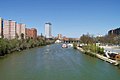
_(cropped).jpg) The river flowing through the Portuguese wine region, designated as a World Heritage Site. | |
.png) | |
 | |
| Location | |
| Country | Spain, Portugal |
| Physical characteristics | |
| Source | Picos de Urbión |
| • location | Sistema Ibérico, Duruelo de la Sierra, Soria, Castile and León, Spain |
| • coordinates | 42°0′38″N 2°52′49″W / 42.01056°N 2.88028°W |
| • elevation | 2,157 m (7,077 ft) |
| Mouth | Foz do Douro |
• location | Atlantic Ocean, Porto, Greater Porto, Norte, Portugal |
• coordinates | 41°8′36″N 8°40′10″W / 41.14333°N 8.66944°W |
• elevation | 0 m (0 ft) |
| Length | 897 km (557 mi) |
| Basin size | 98,400 km2 (38,000 sq mi) |
| Discharge | |
| • location | Porto |
| • average | 700 m3/s (25,000 cu ft/s) |
| • maximum | 17,000 m3/s (600,000 cu ft/s) |
| Discharge | |
| • location | Pocinho |
| • average | 442 m3/s (15,600 cu ft/s) |
| Basin features | |
| Tributaries | |
| • left | Tera, Rituerto, Riaza, Duratón, Cega, Adaja, Tormes, Huebra, Águeda, Côa, Torto, Távora, Varosa, Bestança, Paiva, Arda, Inha |
| • right | Pisuerga, Valderaduey, Esla, Sabor, Tua, Corgo, Tâmega, Sousa |
The Douro (UK: /ˈdʊəroʊ, ˈdʊəruː/, US: /ˈdɔːruː, ˈdɔːroʊ/,[1][2][3][4] Portuguese: [ˈdo(w)ɾu], Mirandese: [ˈdowɾʊ]; Spanish: Duero [ˈdweɾo]; Latin: Durius) is the largest river of the Iberian Peninsula by discharge. It rises near Duruelo de la Sierra in the Spanish province of Soria, meanders briefly south, then flows generally west through the northern part of the Meseta Central in Castile and León into northern Portugal. Its largest tributary (carrying more water than the Douro at their confluence) is the right-bank Esla.[5] The Douro flows into the Atlantic Ocean at Porto, the second largest city of Portugal.
The scenic Douro railway line runs close to the river. Adjacent areas produce port (a mildly fortified wine) and other agricultural produce. A small tributary of the river has the Côa Valley Paleolithic Art site which is considered important to the archaeological pre-historic patrimony, designated a UNESCO World Heritage Site. Within Spain, it flows through the middle of the autonomous community of Castile and León, with the basin spanning through the northern half of the Meseta Central. The latter includes wine producing areas such as the Ribera del Duero DOP.
Name
[edit]The Latin name Durius might have been a Celtic name before the overwhelming Romanization of Iberia. If so, the Celtic root could have been *dubro- (in that family of languages the final vowel sound often changes with context, as in Latin).[6] However, were that the case, the -b-, of which there remains no trace, would not have disappeared, as evidenced by place-names derived from Gaulish *dubron (plural dubra), such as French Douvres and English Dover (3rd/4th-century Dubris; Douvres in French), Spanish Dobra, German Tauber (Dubra-gave 807), and Gaelic/Old Irish dobur "water" and river name Dobhar in Ireland and Scotland.[7] Modern Welsh dŵr "water" is cognate with modern Breton dour and Cornish dur "water" and results from a later typical Brittonic evolution of *dubro-,[7] unknown in the Continental Celtic languages.
The possible origin is the hydronymic root *dur-, which is Pre-Indo-European or Pre-Celtic. Albert Dauzat linked this river name to a Pre-Celtic hydronymic root *dor-, which is well attested in Western Europe: in France Doire, Doron, Douron, etc. and in Italy Dora, etc.[8] The meaning of this element is, however, unknown.[8]
A folk-etymological derivation suggests that the name comes from the Portuguese or Spanish term for "golden".[9][10]
History
[edit]
In Roman times, the river was personified as the god Durius.
Part of the drainage basin might have been severely depopulated in the 8th century. According to Claudio Sánchez-Albornoz this was a deliberate act by Alfonso I of Asturias for the defence of his Kingdom, which led the area to be named Repoblación.
The Douro vinhateiro ("vine-land") of the Douro Valley in Portugal, long devoted to vineyards, has been designated by UNESCO as a World Heritage Site. The wine was taken downriver in flat-bottom boats called rabelos, to be stored in barrels in cellars in Vila Nova de Gaia, just across the river from Porto. Nowadays port wine is transported there in tanker trucks.
In the 1960s and 1970s, dams with locks were built along the river, allowing river traffic into the upper regions in Spain and along the border.
In 1998, Portugal and Spain signed the Albufeira Convention, an agreement on the sharing of trans-boundary rivers to include the Douro, Tagus and Guadiana. The convention superseded an agreement on the Douro, signed in 1927, that was expanded in 1964 and 1968 to include tributaries.[11]
Geography
[edit]

It is the third-longest river in the Iberian Peninsula after the Tagus and Ebro. Its total length is 897 km (557 mi),[12] of which only stretches of the Portuguese section, being below a fall/rapids line, are naturally navigable, by modest rivercraft.[13] The Douro River basin encompasses an area of approximately 97,290 km2 (37,560 sq mi).[14]
In its Spanish section, the Douro crosses the great Castilian meseta and meanders through five provinces of the autonomous community of Castile and León: Soria, Burgos, Valladolid, Zamora, and Salamanca, passing through the towns of Soria, Almazán, Aranda de Duero, Tordesillas, and Zamora.
The most important tributaries in this region are the Pisuerga, passing through Valladolid, and the Esla, which passes through Zamora. This region is generally semi-arid plains, with wheat and in some places, especially near Aranda de Duero, with vineyards, in the Ribera del Duero wine region. Sheep rearing is also important.
The drainage basin borders those of Miño to the north, Ebro to the east, and Tajo to the south.[12][13]
For 112 kilometres (70 mi), the river forms part of the border between Spain and Portugal, in a region of narrow canyons. It formed a historical barrier to invasions, creating a cultural/linguistic divide. In these isolated areas, in which the Aldeadávila Dam impounds the river, there are protected areas: the International Douro Natural Park (on the Portuguese side) and the Arribes del Duero Natural Park (on the Zamoran margin).
The Douro fully enters Portuguese territory just after the confluence with the Águeda River; once the Douro enters Portugal, major population centres are less frequent along the river. Except for Porto and Vila Nova de Gaia at the river mouth, the only population centres of any note are Foz do Tua, Pinhão and Peso da Régua. Tributaries here are small, merging into the Douro along the canyons; the most important are Côa, Tua, Sabor, Corgo, Tavora, Paiva, Tâmega, and Sousa. None of these small, fast-flowing rivers is navigable.
Human geography
[edit]
Major Spanish riverside towns include Soria, Almazán, Aranda de Duero, Tordesillas, Zamora and major Portuguese towns include Miranda do Douro, Foz Côa, Peso da Régua, Lamego, Vila Nova de Gaia, and Porto. The most populous cities along the Douro River are Valladolid and Zamora in Spain, and Porto and Vila Nova de Gaia in Portugal. The latter two are located at the mouth of the Douro at the Atlantic Ocean.
In Portugal, the Douro flows through the districts of Bragança, Guarda, Viseu, Vila Real, Aveiro and Porto. Porto is the main hub city in northern Portugal. Its historic centre has been designated as a UNESCO World Heritage Site because of its significant architecture and history.
Economy
[edit]
These reaches of the Douro have a mesoclimate[specify] allowing for cultivation of olives, almonds, and especially grapes, which are important for making port. The region around Pinhão and São João da Pesqueira is considered to be the centre of port, with its quintas (or farms/estates) that extend along the steep slopes of the river valleys. In the 21st century, many of these are owned by multinational, reputed wine companies.
Recently, a prosperous tourist industry has developed based on river excursions from Porto to points along the Upper Douro valley.
The Douro railway line (Linha do Douro) was completed in 1887; it connects Porto, Rio Tinto, Ermesinde, Valongo, Paredes, Penafiel, Livração, Marco de Canaveses, Régua, Tua and Pocinho.
Pocinho is near the very small city of Foz Côa, which is close to Côa Valley Paleolithic Art site. This is considered important to the archaeological pre-historic patrimony, and it has been designated as a UNESCO World Heritage Site.
Dams
[edit]Fifteen dams have been built on the Douro to regulate the water flow, generate hydroelectric power, and allow navigation through locks. Beginning at the headwaters, the first five dams are in Spain: Cuerda del Pozo, Los Rábanos, San José, Villalcampo and Castro Dams. The next five downstream are along the Portuguese-Spanish border; the first three are owned and operated by Portugal: (Miranda, Picote and Bemposta Dams), while the next two belong to Spain: (Aldeadávila and Saucelle Dams).
The Douro's last five dams are in Portugal, and allow for navigation: Pocinho, Valeira, Régua, Carrapatelo, and Crestuma–Lever dams. Vessels with a maximum length of 83 m (272 ft 4 in) and width of 11.4 m (37 ft 5 in) can pass through the five locks. The highest lock, at Carrapatelo Dam, has a maximum lift of 35 m (114 ft 10 in). The waters of Pocinho lake reach 125 metres (410 ft 1 in) above sea level. Unannounced releases of water from upstream Spanish dams occasionally causes navigation issues in these locks.
Gallery
[edit]-
 The Douro in Zamora (Spain)
 -
 The Pisuerga River (tributary to the Duero) in Valladolid
 -
 The Upper Douro valley where Port wine grapes grow
 -
 The typical rabelo boat and Porto historical district in background
 -
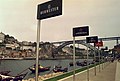 Port wine signs by the Douro River
 -
 Panoramic view of Porto
 -
 The river between Porto and Vila Nova de Gaia
 -
 The river near Régua, Portugal
 -
 Douro Internacional near Miranda do Douro
 -

-
 The river mouth in Porto
 -
 Over Porto
 -
 Douro Estuary
 -
 Looking across the river mouth from Foz do Douro to Vila Nova de Gaia (Atlantic Ocean on the right)
 -
 Typical almond tree, mostly seen along the river in Portugal
 -
 Terraced vineyards near Régua are scattered across the rolling hills, reflecting the river.
.jpg)

.jpg)


.jpg)


See also
[edit]References
[edit]- ^ "Douro". The American Heritage Dictionary of the English Language (5th ed.). HarperCollins. Retrieved March 31, 2019.
- ^ "Douro". Collins English Dictionary. HarperCollins. Retrieved March 31, 2019.
- ^ "Douro" (US) and "Douro". Lexico UK English Dictionary. Oxford University Press. Archived from the original on 2020-07-30.
- ^ "Douro". Merriam-Webster.com Dictionary. Merriam-Webster. Retrieved March 31, 2019.
- ^ Fernández-Aláez, M.; Fernández-Aláez, C.; Luis Calabuig, E. de (1992). "The Esla River Basin: From the Cantabrian Mountain to the Duero" (PDF). Limnetica. 8 (1): 131. doi:10.23818/limn.08.12. S2CID 245777871.
- ^ Ferguson, Robert (1862). The River-names of Europe. Williams & Norgate. pp. 26—.
- ^ a b Delamarre, Xavier (2003). Dictionnaire de la langue gauloise. Éditions Errance. pp. 151–152.
- ^ a b Dauzat, Albert; Deslandes, Gaston; Rostaing, Charles (1978). Dictionnaire étymologique des noms de rivières et de montagnes en France. Paris: Klincksieck. p. 41b.
- ^ Timmons, Nick (1994). Portugal. p. 99.
The Douro... the Golden River (d'ouro means 'of gold')...
- ^ DK Eyewitness Travel Guide Portugal. 2016. p. 239.
...the Douro or 'Golden River' weaves its scenic path through deep-cleft gorges...
- ^ "Spanish-Portuguese Albufeira Convention". un.org. United Nations. Retrieved 18 February 2015.
- ^ a b "Rivers in Spain". iberianature.com. Retrieved 12 August 2017.
- ^ a b "Guide to Spain CO-CU". iberianature.com. Retrieved 12 August 2017.
- ^ Morán-Tejeda, Enrique; Ceballos-Barbancho, Antonio; Llorente-Pinto, José Manuel (May 2010). "Hydrological response of Mediterranean headwaters to climate oscillations and land-cover changes: The mountains of Duero River basin (Central Spain)". Global and Planetary Change. 72 (1–2): 39–49. doi:10.1016/j.gloplacha.2010.03.003. Retrieved 6 January 2023.
External links
[edit]Douro
View on GrokipediaEtymology
Origin and meanings
The name Douro originates from the Latin Durius, the classical Roman term for the river, which personified it as a deity associated with local Iberian worship and depicted with attributes like a fishing net.[8] This nomenclature first appears in written records during the Roman era, notably in Pliny the Elder's Naturalis Historia (circa 77 AD), where the Durius is characterized as one of Hispania's largest rivers, originating among the Pelendones tribe and coursing past the site of Numantia.[9] [10] The etymology of Durius traces to pre-Roman substrates, most plausibly a Celtic hydronym derived from Proto-Celtic *dubros or *dur- signifying "water" or "river," consistent with Indo-European roots for flowing bodies like *dʰwer- (to flow) or *dor-.[11] [12] Alternative interpretations link it to Latin durus ("hard" or "harsh"), evoking the river's tortuous path through steep, rocky terrain and deep gorges, though this is considered secondary to the aquatic connotation by linguists. These Celtic influences reflect the river's significance in pre-Roman Iberian geography, potentially denoting a major watercourse or boundary feature. Linguistic evolution has yielded variant forms: Duero in Spanish, used for the upper and middle reaches in Spain, and Douro in Portuguese for the lower sections in Portugal, arising from medieval phonetic shifts and orthographic standardization in the respective Romance languages.[13] This binational divergence underscores the river's transboundary nature, spanning approximately 885 kilometers from its source in Soria Province, Spain, to the Atlantic estuary near Porto, Portugal.[13]Geography
Physical features and course
The Douro River, called the Duero in Spain, originates near Duruelo de la Sierra in Soria province, within the Pico de Urbión range of the Iberian System, at an elevation of approximately 2,080 meters above sea level.[14][15] It extends westward for a total length of 897 kilometers across the Meseta Central and northern Portugal, ultimately discharging into the Atlantic Ocean through the Porto estuary.[15] The river's drainage basin encompasses 97,290 square kilometers, with the majority in Spanish territory.[6] The upper course, entirely in Spain, navigates through elevated, dissected plateaus and initial gorges of the Sistema Ibérico, where the terrain rises to over 2,000 meters in source areas before descending toward the Portuguese border.[16] Entering Portugal near Miranda do Douro, the middle course carves deep canyons and the Douro International gorge system, incising into resistant schist and granite bedrock formations that form steep, narrow valleys up to 300 meters deep.[17][18] These geological features, primarily Paleozoic metamorphic schists with granitic intrusions, result from tectonic uplift and fluvial erosion over millions of years.[19] Downstream from the gorges, the river's middle reaches transition into broader incisions through the schist-dominated Douro Valley, maintaining a westerly flow with gradients averaging 1-2 meters per kilometer.[20] The lower course flattens near Porto, widening to form a mesotidal estuary extending about 20 kilometers inland, influenced by Atlantic tides and featuring depths up to 10 meters in the middle estuarine zone.[21] Major tributaries joining in the Portuguese section include the left-bank Tâmega and right-bank Côa, which contribute to the river's overall morphology.[22]Hydrology and climate
The Douro River exhibits a pluvial regime driven by Atlantic weather systems, with average annual discharge at the mouth near Porto measuring approximately 700 m³/s, though values fluctuate seasonally between minima under 100 m³/s in summer droughts and peaks exceeding 10,000 m³/s during winter storms.[23] Historical records document extreme floods, such as the 1966 event with a peak discharge of 14,600 m³/s at the Crestuma-Lever dam, which caused widespread inundation along the lower river.[24] The river's flow variability has been substantially moderated since the mid-20th century by a cascade of over 60 dams in the basin, including major installations like the Aldeadávila and Miranda in Spain and Crestuma-Lever in Portugal; these structures trap floodwaters upstream, reducing downstream peak flows by up to 50% in regulated scenarios and stabilizing base flows for much of the year.[25] [26] The Douro basin's climate transitions from continental-Mediterranean conditions in the upper Spanish reaches—characterized by hot, dry summers and cold winters—to a more temperate oceanic regime in the Portuguese lower basin, influenced by proximity to the Atlantic. Annual precipitation averages 618 mm across the basin but varies spatially from 600 mm in arid interior plateaus to 1,200 mm or more in coastal and schistous subregions, with 70% concentrated in the October-to-April wet season due to cyclonic fronts. In the terraced river valleys, diurnal temperature extremes amplify during July and August, when maxima routinely surpass 30°C (often reaching 38°C) under clear skies and föhn-like downslope winds, fostering low humidity and high evapotranspiration rates that constrain summer water availability.[27] [28] [29] Prior to extensive damming in the 1950s–1980s, the Douro transported substantial sediment loads—estimated at 1–2 million tons annually—from erodible granite and schist terrains, sustaining depositional dynamics in the estuary and coastal shelf. Post-dam construction, sediment delivery to the lower river has declined by 80–90%, as reservoirs trap fine particles and reduce flow competence, causally inducing channel incision, bank erosion, and accelerated coastal retreat near the mouth, where net sediment deficits now exceed 500,000 tons per year. This shift has morphologically straightened reaches, deepened the estuary bed by up to 2 meters in places, and diminished natural bar formation, underscoring dams' role in overriding pre-regulation erosion-sedimentation equilibria.[30] [31] [32]Human settlements and land use
The principal human settlements along the Douro River are concentrated in its lower reaches, with Porto functioning as the largest urban center and port at the estuary, flanked by Vila Nova de Gaia across the water.[15] [33] Upstream in Portugal, key towns include Peso da Régua, Lamego, Pinhão, and Pocinho, while the district of Vila Real encompasses broader rural municipalities like Alijó and Armamar.[34] [35] In Spain, settlements such as Salamanca and Zamora anchor the middle basin, though the upper reaches feature sparse villages amid rugged terrain.[35] The upper Douro basin exhibits pronounced rural depopulation and landscape abandonment since the mid-20th century, driven by economic shifts and outmigration, resulting in low population densities and concentrated human activity in select areas.[36] [37] Land use is dominated by anthropogenic modifications, including extensive terracing in the Alto Douro region, where 24,600 hectares form a UNESCO World Heritage cultural landscape shaped by centuries of agricultural adaptation to steep schist slopes.[38] [39] Non-viticultural zones incorporate olive trees, cork oaks, fruit trees, and Mediterranean scrubland, which stabilize soils and support mixed agroforestry amid the vineyards.[40] [41] Urbanization near the estuary imposes significant anthropogenic pressures, including altered hydrodynamics and contamination risks from adjacent metropolitan areas like Porto.[42] In inland gorges, such as the Douro canyon, land use emphasizes preservation through integrated conservation projects that protect natural habitats alongside traditional terracing.[43]History
Ancient and prehistoric settlement
The Douro River basin preserves evidence of Upper Paleolithic human activity, particularly through open-air rock art in the Côa Valley, a major tributary confluence near the Portuguese-Spanish border. Engravings depicting aurochs, horses, and abstract signs, dated via associated sediments and stylistic comparison to 25,000–10,000 BCE, indicate mobile hunter-gatherer groups exploiting riverine ecosystems for fish, game, and lithic raw materials like quartzite.[44] Lithic assemblages from Gravettian layers in the Sabor Valley, north of the Douro, reveal intensive knapping of local quartz and quartzite for tools, underscoring adaptation to the mesolithic transition around 12,000 BCE.[45] Neolithic settlement intensified around 5,000–4,000 BCE, marked by megalithic constructions in upland areas overlooking the Douro. An extensive necropolis in the Aboboreira Mountains near Baião includes over 100 dolmens and menhirs, oriented for solar observation and used for collective burials with grave goods like polished axes, signaling agro-pastoral economies and ritual landscapes tied to valley fertility.[46] Similar structures in the Duero Valley's Late Neolithic phases reflect broader Iberian patterns of territorial markers, though direct river-margin sites remain scarce due to later alluvial deposition.[47] Bronze Age evidence centers on extractive economies in northwest Iberia's tin-rich belts, with placer mining and opencast workings accessible via Douro tributaries for downstream transport. Sites like those in northern Portugal yield cassiterite artifacts and slag from 2000–1000 BCE, supporting regional bronze production, though viticultural precursors are absent in archaeobotanical records.[48] Iron Age communities transitioned to proto-urban hillforts (castros) by 800 BCE, with Celtic-influenced groups like the Gallaeci establishing fortified enclosures in the northern watershed, extending south to the lower Douro. These settlements featured circular huts, granaries, and iron tools, evidencing diversified agriculture and trade networks exploiting river corridors for mobility.[49]Roman era and medieval development
During the Roman period, the Douro River, known as the Durius, served as a vital artery for transporting metals and agricultural goods from the Iberian interior to coastal ports, facilitating trade in resources extracted from the surrounding hinterlands.[15] Roman engineering feats included extensive gold mining operations in the Duero basin, exemplified by sites like Las Médulas, where hydraulic techniques—ruina montium—involved channeling water via aqueducts from tributaries to erode mountainsides and expose ore deposits, yielding an estimated 20 million tons of sediment processed for gold between the 1st and 3rd centuries AD.[50] Similar methods were applied at Tresminas in northern Portugal's Douro region, underscoring the river's role in supplying imperial demands for precious metals.[51] The Romans also established villas and initiated viticulture in the fertile valleys, leveraging the river for irrigation and transport of amphorae containing wine and olive oil, though large-scale export networks were coastal-focused.[52] Following the fall of Rome, Visigothic rule from the 5th to 8th centuries maintained some Roman infrastructure but saw depopulation and fragmentation along the river. The Muslim conquest of 711 AD brought Moorish advancements in irrigation, restoring and expanding Roman aqueducts and norias (water wheels) to cultivate arid terraces, introducing crops like rice and enhancing agricultural output in the Douro's lower reaches.[53] These systems supported feudal-like estates under Umayyad and later Taifa control, with the river aiding internal trade until Christian incursions intensified.[54] The Reconquista reshaped the region from the 11th century, as kingdoms of León and emerging Portugal repopulated the Douro frontier through charters granting lands to settlers and military orders, fostering feudal hierarchies tied to royal defense against Moorish raids. Fortified villages, such as Marialva and those along the Portuguese-Spanish border, emerged with stone walls and hilltop citadels to secure trade routes and agriculture, exemplified by Ucanha's unique medieval bridge over the Varosa tributary.[55] Monasteries played a pivotal role in this development; the Cistercian Mosteiro de São João de Tarouca, founded in 1124, received royal endowments to clear lands and manage vineyards, while Salzedas Abbey (1168) exemplified monastic feudalism by organizing labor and early wine production for ecclesiastical export via Porto's precursor settlements.[56] These institutions stabilized the economy, shifting from extractive mining to agrarian feudalism and laying groundwork for sustained riverine commerce.[57]Early modern wine trade
The Methuen Treaty of 1703 between England and Portugal facilitated increased exports of Portuguese wines, particularly from the Douro region, to Britain by granting preferential tariffs that disadvantaged French competitors amid ongoing conflicts.[58] This agreement spurred demand for fortified Douro wines, which were adapted with added brandy to endure long sea voyages, laying the foundation for port wine's prominence in British markets.[59] By the early 18th century, British merchants established lodges in Porto, organizing the purchase and shipping of these wines, which transitioned the trade from sporadic local exchanges to a structured export-oriented system reliant on river navigation.[60] In 1756, the Marquis of Pombal, as Portugal's prime minister, issued a royal charter demarcating the Douro Valley as the exclusive production area for port wine, establishing the world's first regulated appellation system to combat fraud and ensure quality.[61] He founded the Companhia Geral da Agricultura das Vinhas do Alto Douro to oversee production, pricing, and trade, standardizing practices and prohibiting lower-quality wines from masquerading as port.[60] This regulation shifted the commerce from unregulated wild river transport to a controlled network, with rabelo boats—flat-bottomed wooden vessels designed for the Douro's rapids—ferrying barrels of young wine downstream to maturing cellars in Porto and Vila Nova de Gaia.[62] These boats, crewed by skilled rivermen, navigated seasonal floods and cataracts, enabling efficient bulk transport until mechanized alternatives emerged later.[63] Production expanded markedly under these reforms; annual output in the Douro grew from approximately 152,000 hectoliters in 1772 to 374,000 hectoliters by 1804, reflecting a compound annual growth rate of about 3.5% as port became Portugal's leading export alongside colonial goods.[64] By the 1840s, volumes surpassed 100,000 pipes annually, underscoring the trade's economic dominance.[65] However, the phylloxera epidemic, arriving in the Douro around the 1870s, devastated ungrafted vineyards, prompting widespread replanting with phylloxera-resistant American rootstocks grafted to European Vitis vinifera varieties starting in the late 1870s and accelerating through the 1880s.[66] This adaptation preserved the region's viticultural heritage while enabling recovery, though it temporarily disrupted exports until rebuilt plantings matured in the early 20th century.[67]Industrialization and 20th-century infrastructure
The Linha do Douro railway, constructed between 1873 and 1887, represented a pivotal infrastructural development for the Douro region, extending over 200 kilometers from Porto to the Spanish border at Barca d'Alva.[68] This line supplanted the risky reliance on wooden barques for navigating the river's cataracts, enabling efficient land transport of Port wine casks and other commodities from inland estates to coastal ports, which lowered costs and expanded market access for regional producers.[68][69] By integrating remote valleys into national trade networks, the railway spurred agricultural commercialization and population growth in upstream areas previously isolated by topography.[68] Hydraulic infrastructure advanced markedly in the mid-20th century through dam construction, prioritizing hydroelectric generation and flood regulation. The Bemposta Dam, the earliest significant project, commenced in 1957 with completion in 1964, featuring a 250-meter crest length and 15 MW capacity that harnessed the river's gradient for power output.[70] Followed by facilities like Miranda (1960s inception) and others through the 1970s, these installations proliferated to exceed 15 by century's end, with cumulative capacities surpassing 1,000 MW and supplying approximately 10-15% of Portugal's electricity by stabilizing seasonal flows for consistent baseload energy.[71][72] This expansion not only mitigated downstream flooding risks but also fueled industrial expansion in northern Portugal by providing reliable, low-cost power, indirectly supporting manufacturing and electrification efforts.[71]Economy
Wine production and agriculture
The Douro Demarcated Region, designated as a Denominação de Origem Controlada (DOC) for both fortified Port wines and table wines, spans approximately 43,000 hectares of vineyards, with production concentrated in steep, terraced slopes along the river valley.[73] These vineyards support around 19,000 growers, many managing small, fragmented plots averaging 2 hectares, which contribute to high operational fragmentation and dependency on manual labor.[73][74] Viticultural practices emphasize traditional varieties, with Touriga Nacional as the dominant red grape, comprising a significant portion of plantings and serving as a key component in both Port blends and unfortified Douro reds due to its structure and aroma potential.[75] Other permitted varieties include Touriga Franca, Tinta Roriz, and Tinta Barroca, often field-blended in old vines to enhance complexity, though low yields of Touriga Nacional limit its standalone dominance.[76] Annual wine production, including both Port and DOC table wines, typically yields harvests processed over six weeks across the region, with output metrics reflecting variable weather impacts on yields estimated in the range of tens of millions of liters for certified volumes.[77] Terraced viticulture, historically constructed from schistose rock, imposes substantial costs and labor demands, with manual management on steep slopes proven 2.6 times more expensive than flat terrain equivalents due to intensive pruning, harvesting, and maintenance requirements.[78] Rising minimum wages have further escalated these expenses, exacerbating economic pressures amid fragmented holdings and aging grower populations.[79] Port wine, the region's flagship, sees over 80% of output exported abroad, underscoring reliance on international markets, while EU and national subsidies, including recent crisis measures like distillation support at €0.50 per kilo of grapes, play a critical role in sustaining producers amid oversupply and price volatility.[80][81] Dry farming predominates, relying on residual soil moisture to promote deep root systems and concentrated flavors, though regulatory limits restrict irrigation to establishment phases for new vines, limiting broader adoption despite potential for yield stability in drought years.[82] This approach yields pros such as enhanced terroir expression but cons including vintage inconsistency and water stress risks; irrigation, where permitted via drip or gravity systems, boosts productivity but raises concerns over flavor dilution and regulatory non-compliance penalties.[83] Monoculture tendencies in traditional plantings heighten vulnerabilities to pests, diseases, and soil degradation, prompting calls for diversified sustainable practices to mitigate long-term unsustainability under conventional agrochemical reliance.[84]Tourism and river transport
The designation of the Alto Douro Wine Region as a UNESCO World Heritage Site in 2001 catalyzed a surge in tourism, transforming the valley into a premier destination for scenic river voyages and cultural exploration.[3] This recognition highlighted the region's terraced vineyards and historical viticultural landscape, drawing international visitors seeking immersive experiences along the Douro River. Complementing these river-based attractions, the Douro Valley features several renowned miradouros offering panoramic views of the terraced vineyards and river. These include Miradouro de Casal de Loivos near Pinhão, providing postcard-worthy vistas of the Douro winding through geometric terraces; Miradouro de São Leonardo de Galafura near Peso da Régua, with sweeping bird's-eye perspectives of the river, terraces, and mountains; Miradouro de São Salvador do Mundo near São João da Pesqueira, featuring dramatic vistas of steep slopes and near-360° views; and Miradouro de São Domingos near Provezende, offering peaceful, uninterrupted sights of the river and vineyards. Accessible by car or tour, these viewpoints are particularly striking at sunrise or sunset.[85] By 2024, river transport on the Douro carried 1,377,858 passengers, a 10.64% increase from 2023, reflecting sustained post-pandemic recovery and infrastructure enhancements.[86] River cruises departing from Porto have become a cornerstone of the sector, with hotel ships accommodating approximately 120,150 passengers in 2024, up 12.46% year-over-year, while day excursions saw minor declines amid a shift toward longer stays.[87] These operations evolved significantly after the 1980s dam constructions stabilized water levels, enabling safer navigation for modern vessels compared to the traditional rabelo boats—flat-bottomed wooden craft used until the 1970s to haul port wine barrels downstream against rapids.[63] Today, rabelos serve primarily as tourist attractions for short heritage sails, while purpose-built cruise ships, limited to around 100-138 passengers due to lock constraints, facilitate multi-day itineraries to upstream ports like Régua and Pinhão.[88] This logistical shift has amplified economic effects, with tourism packages generating direct revenue from passenger spending on accommodations, excursions, and local services, thereby supporting employment in hospitality and guiding—though quantitative multipliers remain understudied regionally.[89] Integration with the Douro railway line enhances visitor access, as historic steam trains operate seasonal routes from Régua to Tua, often bundled with river trips to offer panoramic views of the valley's engineered terraces.[90] These combined experiences underscore the post-2000s emphasis on sustainable, multi-modal transport, prioritizing low-impact vessels to preserve the UNESCO site's integrity amid growing demand.[91]Hydroelectric power generation
The Douro River features more than 15 major hydroelectric dams along its course and adjacent basin sections in Portugal and Spain, collectively providing over 5,000 MW of installed capacity dedicated to power generation.[92][6] In Portugal, six principal dams on the main stem— including Miranda, Picote, and Bemposta—account for 1,700 MW of capacity, enabling flexible dispatch for grid stability.[92] These facilities leverage the river's steep gradients in the upper and middle reaches, particularly in the Douro Internacional and Portuguese gorges, to harness gravitational potential for turbine operation. The Picote Dam, commissioned in stages from 1958 onward, holds a net installed capacity of 433 MW across its two units (Picote I at 180 MW and Picote II at 246 MW additional), supporting peak-load demands through its reservoir of 63 million cubic meters.[93][94] Similarly, the upstream Miranda Dam contributes around 200 MW while managing a reservoir volume of 28.1 million cubic meters, facilitating rapid response to demand fluctuations via run-of-river augmentation.[95] On the Spanish side, facilities such as Villalcampo (217.81 MW total across I and II units) and Castro (197.27 MW total) exemplify basin-wide contributions, with aggregate output from major Douro plants exceeding 1,500 MW in Spain alone.[6] These installations supply 20-30% of Portugal's hydroelectric generation needs, bolstering national renewable output amid variable precipitation, with annual production from Portuguese Douro dams reaching hundreds of GWh—such as 898 GWh from Miranda in recent assessments.[96][95] Efficiency is enhanced by selective pumped-storage elements in the basin, allowing energy arbitrage by reversing flow during low-demand periods to refill reservoirs. Cross-border coordination under the 1998 Albufeira Convention, signed on November 30 by Portugal and Spain, standardizes minimum flow releases and operational protocols to optimize hydroelectric yields while maintaining river regime stability.[97] This framework ensures equitable access to hydraulic head for upstream Spanish reservoirs and downstream Portuguese turbines, sustaining reliable baseload and peaking contributions to both countries' grids.Environmental Impacts
Biodiversity and ecosystems
The Douro River basin encompasses diverse habitats, including steep canyons, riparian corridors, and schistose slopes that sustain a range of endemic and specialized species. Freshwater ecosystems feature native cyprinid fishes such as the Iberian barbel (Luciobarbus bocagei), which occupies slow-moving sections of the river and its tributaries, alongside other endemic forms like the comizo barbel (Luciobarbus comizo). Surveys document at least five barbel species in Portuguese reaches, reflecting the basin's historical ichthyofaunal richness dominated by Iberian endemics. Amphibians including the Lusitanian salamander (Chioglossa lusitanica) and Iberian water frog (Pelophylax ibéricus) inhabit stream edges, while invertebrates support complex food webs in these aquatic environments.[98][99][100] Terrestrial biodiversity thrives in canyon cliffs and valleys, with raptors like the griffon vulture (Gyps fulvus) maintaining key colonies in the Douro International Natural Park, where over half of Portugal's population reproduces on granite escarpments. Other avifauna includes Egyptian vultures (Neophron percnopterus), golden eagles (Aquila chrysaetos), and black storks (Ciconia nigra), preying on diverse small mammals and reptiles. Mammal assemblages comprise roe deer (Capreolus capreolus), wild boar (Sus scrofa), otters (Lutra lutra), and European wildcats (Felis silvestris), with threatened bat colonies utilizing caves. In the Arribes del Duero Natural Park, spanning the Spanish-Portuguese border, predatory birds such as peregrine falcons (Falco peregrinus) and eagle owls (Bubo bubo) exploit the rugged terrain, alongside stork populations. Historical faunal records from the 19th-20th centuries indicate stable predator guilds tied to ungulate abundances, with current inventories confirming persistence of these assemblages in protected zones.[101][102][103] Vegetation communities vary by elevation and substrate, with riparian galleries along tributaries featuring alder (Alnus glutinosa), willow (Salix spp.), and ash (Fraxinus excelsior) stands that stabilize banks and provide habitat connectivity. Upper basin schistose soils, fractured and heat-retaining, host xerophytic scrub and herbaceous plants adapted to oligotrophic conditions, including drought-tolerant species on outcrops that enhance microhabitat diversity. In canyon areas like Arribes del Duero, well-preserved cliff vegetation includes relict juniper (Juniperus spp.) and oak woodlands (Quercus spp.), with gall oak (Quercus faginea) and cork oak (Quercus suber) forming islands of evergreen forest. Empirical floristic surveys highlight these formations' role in maintaining species richness, with historical botanical accounts from the early 20th century noting similar gallery forest extents pre-intensive agriculture. Protected designations, such as the Arribes del Duero and Douro International parks, encompass over 100,000 hectares of these habitats, safeguarding endemic vascular plants and fungal associates.[99][104][105]Effects of dam construction
The construction of over a dozen major dams along the Douro River since the 1950s has regulated its flow regime, attenuating peak discharges and providing flood mitigation benefits. Pre-dam historical records document frequent severe floods in the lower basin, including events exceeding 1,000 m³/s that caused inundation in Porto and the estuary; post-dam data from gauging stations indicate reduced frequency and magnitude of such extremes due to reservoir storage and controlled releases, with basin-wide infrastructure credited for averting damages equivalent to historical levels. This hydrological stabilization has lowered flood risks in riparian areas, though it has also diminished natural flow variability essential for certain ecosystem processes.[106][107][108] Reservoir sedimentation has emerged as a principal long-term effect, with trapping of suspended loads leading to capacity losses estimated at 0.16% annually in large Douro reservoirs, based on volumetric surveys and modeling of inflow sediments. This process fragments the river continuum, accumulating fine particles behind impoundments and altering downstream geomorphology. Basin-wide, dams have curtailed sediment flux to the Atlantic by approximately 0.25 × 10^6 m³ per year, exacerbating coastal erosion between the Douro mouth and Nazaré through diminished littoral supply, as evidenced by bathymetric changes and shoreline retreat rates post-1970s damming intensification.[109][110][111] Ecological fragmentation from dams impedes upstream migration of diadromous species like sea lamprey and shad, with installed fish passages—such as Borland locks and ladders—demonstrating limited efficacy in restoring passage, as upstream-downstream connectivity remains poor in monitored reaches. Water quality exhibits mixed outcomes: reduced turbidity from sediment retention improves downstream clarity, but reservoir stagnation fosters localized hypoxia and shifts in nutrient cycling, potentially elevating algal risks during low-flow periods. These alterations underscore trade-offs, where flood control gains contrast with diminished sediment and biotic transport to estuarine and marine realms.[106][112][113]Climate change vulnerabilities
 principles, highlighting shifts toward organic viticulture and reduced chemical inputs as evidence of sustainability. By the 2020s, Portugal's broader wine sector, including Douro, has seen expansion in certified organic production, with industry reports emphasizing diversification into sustainable practices to meet global demand for eco-friendly wines.[142] However, empirical data reveals persistent pesticide residues in Douro vineyard soils, particularly elevated copper levels and traces of banned insecticides in older plots, undermining claims of minimal environmental impact.[143] Water management improvements, such as deficit irrigation, have enhanced efficiency in this naturally water-stressed region, yet vulnerability to intensifying heatwaves—projected to accelerate ripening and elevate alcohol levels—poses ongoing risks to yield stability.[144][145] Terraced landscapes, iconic to Douro viticulture, are marketed as low-erosion systems preserving soil integrity, with long-term studies recording average annual soil losses of 0.36 tons per hectare, attributed to high rock fragment content stabilizing slopes.[146] This contrasts with broader European erosion averages of 2.46 tons per hectare per year in erosion-prone lands, supporting arguments for terracing's role in conservation.[147] Nonetheless, monoculture dominance in vineyards contributes to biodiversity concerns, as chemical applications devastate local ecosystems, prompting calls for regenerative approaches to restore functional agrobiodiversity.[148][149] Economic analyses challenge the viability of these sustainability claims without external support, as low yields—averaging 4.1 tons per hectare against authorized maxima—coupled with grapes often sold below production costs, drive vineyard abandonment and question unsubsidized profitability.[150][151][152] Romanticized notions of "terroir purity" overlook historical interventions, including phylloxera devastation in the late 19th century that necessitated replanting and agricultural reforms, altering varietal compositions and challenging narratives of uninterrupted natural authenticity.[153][154] Global competition further pressures these systems, where marketing emphasizes heritage over adaptive necessities like genetic diversification to counter pests and climate shifts.[155]References
- https://en.wiktionary.org/wiki/Durius
- https://en.wiktionary.org/wiki/Douro