Hubbry Logo
HelikeHelikeMain
Open search
Helike
Community hub
Helike
logo
8 pages, 0 posts
0 subscribers
Be the first to start a discussion here.
Contribute something
Helike
Helike
from Wikipedia

Helike (/ˈhɛlɪk/; Greek: Ἑλίκη, pronounced [heˈlikɛː], modern Greek pronunciation: [eˈlici]) was an ancient Greek polis or city-state[1] that was submerged by a tsunami in the winter of 373 BC.

Key Information

It was located in the regional unit of Achaea, northern Peloponnesos, two kilometres (12 stadia) from the Corinthian Gulf and near the city of Boura, which, like Helike, was a member of the Achaean League. Modern research attributes the catastrophe to an earthquake and accompanying tsunami which destroyed and submerged the city.

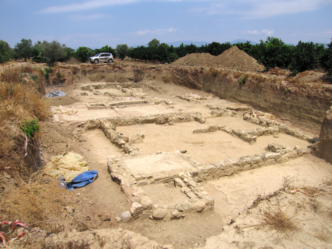
The remains of Helike were rediscovered in 2001 buried in an ancient lagoon near the village of Rizomylos. In an effort to protect the site from destruction, the World Monuments Fund included Helike in its 2004 and 2006 List of 100 Most Endangered Sites.[2]

History

[edit]
Map of area. Helike marked "Ελίκη".
A Hellenistic-era building, possibly used as a dye-works
A coin from Helike

Helike was founded in the Early Bronze Age (c. 3000–2200 BC) as a proto-urban town with large rectilinear buildings and cobbled streets; walls and occupation layers rich in pottery of the Mycenaean period (c. 1750–1050 BC) were also found,[3] becoming the principal city of Achaea. In the Iliad, the poet Homer states that the city of Helike participated in the Trojan War as a part of Agamemnon's forces.[4] In the space of a possible little Poseidon temple, beginning around 850 BC, religious artifacts like bronze and clay items such as figurines, clay chariot wheels, iron weapons, and pottery dating to the Archaic period, a bronze snake head and rare golden necklace were found.[5]

Later, following its fall to the Achaeans, Helike led the Achaean League, an association that joined twelve neighboring cities in an area including today's town of Aigio. Helike, also known as Dodekapolis (from the Greek words dodeka meaning 'twelve' and polis meaning 'city'), became a cultural and religious center with its own coinage. Finds from ancient Helike are limited to two 5th-century copper coins, now housed in Bode Museum, Berlin. The obverse shows the head of Poseidon, the city's patron, and the reverse his trident.[6] There was a temple dedicated to the Helikonian Poseidon. Ancient Greeks would travel to Helike to be blessed by Poseidon and to trade.

Helike founded colonies including Priene in Asia Minor and Sybaris in Southern Italy. Its panhellenic temple and sanctuary of Helikonian Poseidon were known throughout the classical world, and second only in religious importance to Delphi.[7]

Destruction

[edit]

The ancient account puts Helike's destruction in 373 BC, two years before the Battle of Leuctra, during a winter night. Several events were construed in retrospect as having warned of the disaster: some "immense columns of flame" appeared, and five days previously, all animals and vermin fled the city, going toward Keryneia.[8] The city and a space of 12 stadia below it sank into the earth and were covered over by the sea. All the inhabitants perished without a trace, and the city was obscured from view except for a few building fragments projecting from the sea. Ten Spartan ships anchored in the harbour were dragged down with it. An attempt involving 2,000 men to recover bodies was unsuccessful.[9] Aigion took possession of its territory.[10]

Strabo recounts how the city was submerged by a tsunami triggered by an earthquake, and argued that this was caused by "the anger of Poseidon", because the inhabitants of Helike had refused to give their statue of Poseidon to the Ionian colonists in Asia, or even to supply them with a model. According to some authorities, the inhabitants of Helike and Bura had even murdered the Ionian deputies. An account by Seneca claims the sea destroyed the city after an appearance of a comet.[11]

About 150 years after the disaster, the philosopher Eratosthenes visited the site and reported that a standing bronze statue of Poseidon was submerged in a "poros", "holding in one hand a hippocamp", where it posed a hazard to those who fished with nets.[12] The meaning of poros in ancient Greek is not fully clear, but could refer to an inland lagoon, lake, or narrow strait. Most archaeologists thought it referred to the Gulf of Corinth, but there was disagreement from Professor Dora Katsonopoulou:

For the sea was raised by an earthquake and it submerged Helice, and also the temple of the Heliconian Poseidon, whom the Ionians worship even to this day, offering there the Pan-Ionian sacrifices. And, as some suppose, Homer recalls this sacrifice when he says: "but he breathed out his spirit and bellowed, as when a dragged bull bellows round the altar of the Heliconian lord."

...

Helice was submerged by the sea two years before the battle at Leuctra. And Eratosthenes says that he himself saw the place, and that the ferrymen say that there was a bronze Poseidon in the strait, standing erect, holding a hippo-campus in his hand, which was perilous for those who fished with nets. And Heracleides says that the submersion took place by night in his time, and, although the city was twelve stadia distant from the sea, this whole district together with the city was hidden from sight; and two thousand men who had been sent by the Achaeans were unable to recover the dead bodies; and they divided the territory of Helice among the neighbors; and the submersion was the result of the anger of Poseidon, for the lonians who had been driven out of Helice sent men to ask the inhabitants of Helice particularly for the statue of Poseidon, or, if not that, for the model of the temple; and when the inhabitants refused to give either, the Ionians sent word to the general council of the Achaeans; but although the assembly voted favorably, yet even so the inhabitants of Helice refused to obey; and the submersion resulted the following winter; but the Achaeans later gave the model of the temple to the lonians.

— Strabo, Geographica, 8.7.2

Around 174 AD, the traveler Pausanias visited a coastal site still called Helike, located seven kilometres southeast of Aigio, and reported that the walls of the ancient city were still visible underwater, "but not so plainly now as they were once, because they are corroded by the salt water".[13]

For centuries after, its submerged ruins could still be seen. Roman tourists frequently sailed over the site, admiring the city's statuary. Later the site silted over and the location was lost to memory.

Adalberto Giovannini [de] argued that the submergence of Helike might have inspired Plato to end his story about Atlantis with its submersion.[14] Ancient scholars and writers who visited the ruins include the Greeks Strabo,[15] Pausanias and Diodoros of Sicily,[16] and the Romans Aelian[8] and Ovid.[17]

Subsequent events

[edit]

On 23 August 1817, a similar disaster, an earthquake followed by a tsunami, occurred at the same spot. The earthquake was preceded by a sudden explosion, like that produced by a battery of cannon. The aftershock was said to have lasted a minute and a half, during which the sea rose at the mouth of the Selinous River and extended to cover all the ground immediately below Aigio (the ancient Αἴγιον). After its retreat, not a trace was left of some artillery depots which had stood on the shore, and the beach was carried away completely. In Aigio, 65 people died and two-thirds of its buildings were entirely ruined, as were five villages in the plain.[18]

Rediscovery

[edit]

Previous attempts

[edit]

The submerged town was long a mystery for underwater archaeology. People were divided in their opinions about the exact location of Helike and produced numerous works and hypotheses:

In 1826, French diplomat and archaeologist François Pouqueville, who wrote the Voyage en Grèce;[19] in 1851 Ernst Curtius the German archaeologist and historian who speculated about its location;[20] in 1879 J. F. Julius Schmidt, the director of Athens Observatory, issuing a study comparing the Aegeion earthquake which occurred 26 December 1861 with an earthquake which might have destroyed Helike;[21] in 1883 Spiros Panagiotopoulos, the mayor of Aegeion city, wrote about the ancient city; in 1912 the Greek writer P. K. Ksinopoulos wrote The City of Aegeion Through the Centuries[22] and in 1939 Stanley Casson, an English art scholar and army officer who studied classical archaeology and served in Greece as liaison officer, addressed the problem.

Other investigators include in 1948 the German archaeologist Georg Karo; in 1950 Robert Demangel, who was from 1933 to 1948 the director of the French School of Archaeology in Athens; in 1950 Alfred Philippson, German geologist and geographer; in 1952 Spiros Dontas, Greek writer and member of the Academy of Athens; in 1954 Aristos Stauropoulos, a Greek writer who published the History of the city of Aegeion;[23] in 1956 the Greek professor N. Κ. Moutsopoulos; in 1967 Spyros Marinatos, a Greek archaeologist who wrote the Research about Helike[24] and in 1968 Helike-Thira-Thebes;[25] in 1962 the Greek writer George K. Georgalas; and in 1967 Nikos Papahatzis, a Greek archaeologist who published Pausanias’ Description of Greece.[26]

Spyridon Marinatos said that only the declaration of a third world war would obscure the discovery of Helike.[27] In 1967, Harold Eugene Edgerton worked with the American researcher Peter Throckmorton. They were convinced that Helike was to be found on the seabed of the Gulf of Corinth. Edgerton perfected special sonar equipment for this research but permission to search was not granted by the Greek authorities.

In 1967 and in 1976, Jacques Cousteau searched for Helike, with no result. In 1979 in the Corinthian Gulf, the Greek undersea explorer Alexis Papadopoulos discovered a sunken town and recorded his findings in a documentary film which shows walls, fallen roofs, roof tiles, streets, etc. at a depth of between 25 and 45 m.[28] "Whether or not this town can be identified with Helike is a question to be answered by extensive underwater research. In any case, the discovery of this town can be regarded as an extremely interesting find", according to the Greek scientific journal Archaeology.[29]

Rediscovery in 2001

[edit]

In 1988, the Greek archaeologist Dora Katsonopoulou, president of the Helike Society, and Steven Soter of the American Museum of Natural History launched the Helike Project to locate the site of the lost city.[30] Ancient texts, telling the story of Helike, said that the city had sunk into a poros, which everyone interpreted as the Corinthian Gulf. However, Katsonopoulou and Soter raised the possibility that poros could have meant an inland lagoon. If an earthquake caused soil liquefaction on a large scale, the city would have been taken downward below the sea level. Also, if an earthquake caused the sections of coastline to fall into the sea, this would have created a tsunami, which in turn would have flooded the inland lagoon with the city in it. Over time, the river sediment coming down from the mountains would have filled in the lagoon hiding the city remains beneath the solid ground.[31]

Before Helike was rediscovered, a few false starts came along the way. In 1994, in collaboration with the University of Patras, a magnetometer survey carried out in the midplain of the delta revealed the outlines of a buried building. This target (now known as the Klonis site) was excavated and a large Roman building with standing walls was found.[30] Also a well-preserved settlement of the early Bronze Age was uncovered.

In 2001, Helike was rediscovered buried in an ancient lagoon near the village of Rizomylos.[32] Further confirming that the discovered site belongs to Helike, the earthquake destruction layer consisting of cobblestones, clay roof tiles, and pottery was uncovered in 2012. This destruction layer is in good agreement with ancient texts on the location of Helike and earthquake effects to the city.[33]

Excavations are being carried out in the Helike delta each summer and have brought to light significant archaeological finds dating from prehistoric times, when Helike was founded, up until its revival in Hellenistic and Roman times.[32][34][35][36]

Research Published in May 2025 combined archaeological and geological data, to present the first complete seismic history of the Helike Fault over nearly three millennia, identifying previously unknown earthquakes and establishing that major disasters occurred roughly every 300 years between Geometric and Roman times. The timeline revealed a pattern of societal resilience, where inhabitants consistently resettled the catastrophe-prone area by adapting their settlement locations and building methods to the dynamically changing landscape.[37]

See also

[edit]

References

[edit]
[edit]
Revisions and contributorsEdit on WikipediaRead on Wikipedia
from Grokipedia
Helike was an city-state situated on the southwestern shore of the in the region of , renowned as a major cult center dedicated to the god and the administrative seat of the Achaean League's Dodekapolis. The city, mentioned in Homer's Iliad as part of Agamemnon's contingent at , flourished from the Early (circa 2500–2300 BC) through the Classical period, establishing colonies such as in and in Asia Minor that propagated the worship of . In 373 BC, Helike was devastated by a catastrophic earthquake, traditionally attributed to divine wrath from Poseidon, which caused the coastal plain to subside and unleashed a seismic sea wave that submerged the city and drowned its inhabitants, according to ancient writers like Pausanias and Strabo. This event not only erased the city from the map but also inspired legends of its ruins remaining visible underwater for centuries, visible to fishermen as a "bronze trident" or submerged buildings. While geoarchaeological studies confirm seismic activity and subsidence, the extent of a tsunami remains debated, with evidence suggesting the city may have partially persisted post-event before eventual abandonment and burial under sediments; a 2025 study further reveals multiple relocations and rebuilds in response to repeated seismic events over three millennia. The site's rediscovery in 2001 by the Helike Project, after decades of searches initiated by archaeologist , uncovered a "time capsule" preserved in marine mud, including an Early town, a possible Classical royal palace () with gold and silver ornaments, and Roman-era roads connecting to and . Recent excavations have revealed structures linked to Poseidon's , such as an 8th-century BC arched temple, a 7th–6th-century BC stone foundation resembling a temple, and artifacts including bronze figurines, clay wheels, iron weapons, and a rare golden necklace, indicating ritual sacrifices and continuous religious activity from around 850 BC. Ongoing fieldwork, including the 2025 season, continues to highlight Helike's value as a unique window into seismic impacts on ancient societies.

Etymology and Mythology

Name and Origins

The name Helike (Ancient Greek: Ἑλίκη) derives from the Greek word ἑλίκη, denoting a "twist," "spiral," or "coil," which may allude to the winding of the surrounding region or to the flexible branches of trees (ἑλίκη also signifies "") common in riverine areas. This linguistic root connects to broader Indo-European terms for turning or winding forms, though the precise application to the settlement remains interpretive. Alternatively, the name is tied to a mythological named Helike, one of several figures in Greek lore bearing that , including a nurse of the infant on who was transformed into the constellation (also called Helike for its apparent rotation around the ). In Greek mythology, Helike appears as an eponymous heroine, the daughter of the river god Selinus (after whom the nearby Selinus River is named) and wife of Ion, the mythical progenitor of the Ionian Greeks and son of Xuthus. Their union produced a daughter, Bura, eponym of the nearby city of Bura, establishing Helike's foundational role in Achaean lore as the site where Ion established his domain. Pausanias recounts this genealogy to explain the origins of local place names, linking Helike directly to the Ionians' ancestral narratives. Ancient texts reference Helike as a significant Achaean settlement, notably in Homer's (Book 2, lines 575–577), where it is listed among the coastal cities contributing ships to Agamemnon's fleet during the : "And those who held Helice and Aegium... these sent a hundred ships." This mention highlights Helike's early prominence as a maritime power in the region. As the purported founding site of , Helike functioned as an early mythological center for the , serving as their capital before migrations led to colonies in Minor, such as , and southern Italy, like . The city's cult of Helikonios further reinforced these origins, blending local identity with pan-Hellenic reverence.

Association with Poseidon

Helike held a central role in the worship of within , serving as the primary cult center for the god under his Helikonios, which evoked his ancient associations with the sea, earthquakes, and the region's mythological foundations. The dedicated to Helikonios was renowned as a pan-Hellenic site, particularly revered by the , who regarded it as their most ancient and sacred shrine; even after their migration to Asia Minor, they continued the cult through altars and precincts in cities such as and . Ancient rituals at the emphasized Poseidon's dominion over natural forces and included sacrificial offerings, with pilgrims traveling from afar to participate in ceremonies that reinforced communal ties among Ionian . Pausanias describes horse sacrifices as a key element in Poseidon's broader practices, symbolizing the god's invention of the and his mastery over equestrian arts, while processions likely formed part of the festivals to honor him, as evidenced by the 's role in drawing worshippers for collective rites. Central to the cult was a renowned bronze statue of , reportedly removed from the city prior to its submergence in 373 BC yet rediscovered standing upright in the coastal waters, where it remained visible for centuries as a haunting emblem of the god's power. , visiting the site about 150 years after the event, recorded accounts from local ferrymen of the statue's eerie presence in a submerged channel, its outstretched form entangling fishing nets and serving as a perpetual reminder of Helike's sacred legacy.

Geography and Environment

Location in Antiquity

Helike was an ancient Greek city located on the fertile coastal plain along the southwestern shore of the , in the region of within the northern . The site occupied a strategic position approximately 2 kilometers (12 stadia) inland from the sea, as described by the ancient geographer , placing it in a low-lying area conducive to maritime activities. Modern estimates situate the ancient coordinates near 38°13′N 22°08′E, between the contemporary towns of Rizomylos and Rodia, east of Aigion and west of Xylokastro. This positioning integrated Helike into the broader landscape of , where it served as the political and religious center of the twelve-city (Dodekapolis), leading the confederation during the Classical period. Ancient authors like Pausanias further specified Helike's placement, noting it lay 40 stadia (about 7.4 kilometers) east of the city of Aegium (modern Aigion), on a plain near the mouth of the Selinos River, adjacent to the neighboring polis of Boura. As a prominent coastal settlement, Helike functioned as a vital hub for trade and navigation, facilitating exchanges across the and beyond, with evidence of overseas commerce dating back to the through imported goods and maritime artifacts. Its Ionian origins, attributed to the mythical founder , underscored its role in connecting Achaean networks to Ionian colonies, such as in Asia Minor, enhancing its economic and cultural influence as a gateway for seafaring in the region. The city's location on this , nourished by rivers like the Selinos and Kerynites, supported agricultural prosperity while exposing it to the dynamic tectonics of the Corinth Rift, a factor in its environmental setting.

Geological Context

Helike is situated on the southwestern shore of the , a highly active continental within the Aegean plate boundary, where the African plate subducts beneath the Eurasian plate, driving north-south extension at rates of 10–15 mm per year and generating frequent earthquakes through normal faulting along segments like the Helike Fault. This tectonic setting places the site in the hanging wall of the north-dipping Helike Fault, with the uplifting Peloponnesos forming the adjacent footwall block, resulting in a dynamic landscape prone to seismic activity and associated ground movements. The coastal environment around Helike features a Gilbert-type fan delta formed by coalesced alluvial deposits from the Selinous and Kerynites rivers, creating marshy terrain and brackish lagoons characterized by heterogeneous sediments ranging from coarse clastics to fine clays. Microfaunal assemblages in these deposits, including and ostracods indicative of freshwater, brackish, and marine conditions, reveal recurrent shifts between lagoonal submergence and exposure over millennia, with sediment deposition burying and preserving submerged features. This low-lying, waterlogged setting amplified vulnerability to tectonic influences, as evidenced by showing depths averaging 16 meters of unconsolidated sediments. Long-term landscape evolution in the Helike Delta reflects alternating phases of gradual tectonic uplift and episodic , with an average uplift rate of 2.4 ± 0.8 meters per thousand years counteracting seismic downdrops to produce minimal net vertical displacement. Elevated fossil shorelines and marine sedimentary horizons east of the Vouraikos River demonstrate this uplift pattern, while ongoing sedimentation from fluvial sources has prograded the delta, transforming submerged into emergent plains over time. Recent research (as of 2025) identifies six major earthquakes in the area over the past 10,000 years, including uplift of 6–7 meters around 2100 BC that buried Early structures under sediments, and of 4–9 meters during the 373 BC event, which led to flooding and formation, further illustrating the rift-related extension's role in shaping this geologically unstable coastal zone since at least the Early . These processes, driven by rift-related extension, have shaped a geologically unstable coastal zone since at least the Early .

History

Prehistoric Foundations

The earliest evidence of human activity in the Helike area dates to the period, with ceramic fragments recovered from sediment cores in boreholes along the coastal plain between the Selinous and Kerynites rivers. These finds indicate sporadic occupation horizons spanning from times through later periods, suggesting initial human presence in a lagoonal environment conducive to early settlement. By the Early Bronze Age (Early Helladic II-IIIA, ca. 2600–2300 BC), Helike emerged as a proto-urban settlement, evidenced by excavations at Rizomylos revealing corridor houses, cobbled streets, and a variety of artifacts including such as depas amphikypellon cups, bowls, jars, and pithoi with finger-impressed decorations, alongside tools, spindle whorls, seashells, and animal s. This settlement, located about 1 km from the present shore and buried 3–5 m deep, reflects advanced building techniques and coastal adaptation, with overlying sediments containing marine and lagoonal indicating post-abandonment submergence. The site covered a significant area, demonstrating organized community life with influences from broader mainland Early Helladic networks. In the Late Bronze Age (Mycenaean period, ca. 1600–1100 BC), a substantial settlement occupied an area exceeding 20,000 sq. m. near the Helike plain, featuring chamber tombs and linking it to wider Mycenaean palatial systems. This phase laid foundations for cultural continuity, with the site's strategic coastal position fostering trade and influences that persisted into the Early . Around 1000 BC, Helike transitioned into an early Ionian center, traditionally associated with the arrival of , leader of the Ionian race, building on Mycenaean precedents to establish it as a key hub in the region. Geological-archaeological studies through 2025, integrating excavations, sediment analysis, and tectonic modeling, confirm continuous habitation patterns in the Helike delta over approximately 3,000 years, from the onward, evidenced by stratified layers of artifacts, walls, and destruction horizons reflecting repeated environmental adaptations across multiple site phases.

Classical Period Prosperity

During the Classical period, particularly in the 5th and early 4th centuries BC, Helike emerged as a leading in the northern , serving as the religious and political capital of the first , a of twelve Achaean cities. This leadership position enabled Helike to coordinate federal decisions and foster unity among the member states, including the establishment of shared institutions and the foundation of colonies such as in Asia Minor and in , which extended Achaean influence across the Mediterranean. The city's prominence is evidenced by archaeological finds, including Classical-period pottery and coins depicting , underscoring its central role in league governance. Helike's economy thrived on its strategic coastal location along the , supporting a diverse base of , , and maritime . Fertile plains facilitated the cultivation of crops like grains and olives, while the adjacent sea provided abundant resources, contributing to local sustenance and surplus production. The served as a vital hub for exchanging goods with other Greek regions and beyond, as indicated by imported and coarse wares dated to the early recovered from excavation sites. This economic vitality not only sustained the city's population but also funded its participation in broader regional networks, enhancing its prosperity before the mid-4th century. Culturally, Helike held significant prominence through its pan-Hellenic sanctuary dedicated to Helikonios, which attracted worshippers from across the Greek world and reinforced the city's ties to Ionian communities. As leader of the , Helike participated in alliances that navigated tensions with , including efforts to maintain autonomy amid Peloponnesian rivalries in the late 5th and early 4th centuries BC. These engagements highlighted Helike's diplomatic influence, with the league occasionally seeking or leveraging Spartan support while asserting regional independence.

Destruction in 373 BC

On a winter night in 373 BC, Helike was devastated by a major centered in the seismically active , which caused widespread structural collapse and ground across the . Ancient reports, preserved through later historians, describe the earth opening up beneath the city, swallowing buildings and inhabitants in chasms before the ground resettled. According to ancient accounts, this seismic shock was followed almost immediately by a or massive surge, as the reportedly surged inland, inundating the low-lying settlement and its surrounding territory up to several kilometers. While ancient writers describe a devastating , modern geoarchaeological research debates its occurrence and extent, with some evidence pointing to , mudflows from landslides, or other flooding mechanisms rather than a classic seismic wave. Eyewitness and near-contemporary accounts emphasize the sudden and total nature of the catastrophe. Pausanias, writing in the 2nd century AD, recounts that the "swallowed up" the city of Helike and its people, leaving no visible traces on the surface, while a subsequent "wave of the sea overwhelmed the city and the sacred grove of ," submerging rooftops and tree tops beneath the waters. , drawing from earlier sources, notes that multiple s during the night were accompanied by floods that "engulfed" Helike and the neighboring city of Bura, with a massive sea wave destroying all inhabitants and structures in its path. The Roman later alluded to the event in his , stating that seekers of Helike and Bura would find the Achaean cities "beneath the waves," visible to sailors from the surface. The human toll was catastrophic. A rescue party of approximately 2,000 men was dispatched but recovered no bodies, suggesting a high death toll among the city's population. No bodies were recovered in the aftermath, as the site was rapidly buried under a thick layer of and from the event and subsequent silting, preserving the ruins in an anaerobic environment but rendering impossible. , visiting the area about 150 years later, reported seeing a bronze statue of standing upright in shallow waters offshore, pointed out by local ferrymen as a remnant of the submerged city, underscoring the permanence of the inundation.

Post-Destruction Adaptations

Following the devastating and of 373 BC, the survivors of Helike relocated to higher ground approximately 1.5 kilometers west of the original site, establishing a new settlement in the western Helike plain known as Eliki-Valimitika within decades. This adaptation allowed the community to resume activities as a regional center for textile production and trade during the , with archaeological evidence revealing rebuilt structures using more resilient polygonal techniques. Over the subsequent centuries, Helike demonstrated remarkable resilience amid recurrent seismic activity in the seismically active . A 2025 multidisciplinary study by the Helike Project documented three major site shifts due to s across approximately 3,000 years of occupation, including post-373 BC relocations that responded to land subsidence, flooding, and tectonic uplift. Notably, around 90–80 BC, another destructive prompted a shift eastward to sites at Rizomylos and Nikolaiika, where the city was rebuilt as a Roman settlement featuring imported ceramics and persisting from the late into the mid-5th century AD. This pattern of destruction and reconstruction—marked by four major s with recurrence intervals of 288–530 years—underscored the inhabitants' adaptive strategies, such as elevating foundations to mitigate flood risks. By the Roman era, Helike's prosperity waned amid escalating environmental pressures, culminating in a severe around 420–450 AD that collapsed buildings and caused violent deaths, as evidenced by skeletal remains beneath rubble at Nikolaiika. The site was largely abandoned thereafter, with no significant occupation resuming due to the cumulative impact of seismic hazards and shifting river courses in the delta. Nonetheless, the legacy of the submerged ruins endured in cultural memory, with references to visible remnants in the lagoon persisting into the Middle Byzantine period (9th–10th centuries AD).

Archaeological Rediscovery

Early Modern Searches

The search for ancient Helike during the was driven by fascination with ancient literary accounts of its dramatic destruction and submersion in 373 BC, as described by authors like and Pausanias, which fueled myths of a visible offshore. In the , European travelers and topographers, including Edward Dodwell, William Martin Leake, and François Pouqueville, systematically explored the coastal plain near modern Aigion in the , attempting to correlate ancient texts with local topography to pinpoint the site's location. Dodwell, in his detailed travelogue, suggested a position inland from the shore based on Pausanias' descriptions of nearby landmarks, while Leake mapped potential alignments with ancient river courses and ruins, noting the area's seismic history as a clue to the site's obscurity. These efforts yielded preliminary identifications but no concrete archaeological evidence, hampered by the absence of visible structures and reliance on imprecise ancient itineraries that did not account for post-classical landscape changes. Interest revived in the 20th century, particularly after the 1950s, when Greek archaeologist , renowned for his work at Akrotiri on , turned to Helike as a potential analog for volcanic and seismic catastrophes in Greek antiquity. In a seminal 1960 article, Marinatos reviewed the historical and geological context, proposing that the city lay buried under sediment or submerged in the gulf, and he initiated on-land surveys using aerial photographs and local testimonies to narrow search areas southeast of Aigion. Despite these advances, Marinatos' expeditions in the 1960s and 1970s, including collaborations with underwater explorers like , failed to locate the site, as submersible probes and dives encountered only modern debris and thick marine sediments without classical artifacts. The 1980s marked a shift to systematic geophysical methods through the Helike Project, led by archaeologist Dora Katsonopoulou and geophysicist Steven Soter, who conducted extensive magnetometry, resistivity surveys, and over 100 boreholes across a 2 km² to detect buried horizons. These investigations uncovered multilayered occupation debris, including sherds from the Early Helladic to Byzantine periods and traces of walls at depths of 1.5–4 meters, confirming long-term human activity but not the specific classical destruction layer amid alluvial silts up to 15 meters thick. Efforts were severely impeded by modern development, such as the construction of the and agricultural intensification, which disturbed potential sites and restricted access, while the persistent of fully submerged —echoing ancient reports of the vanishing into the —diverted focus to despite evidence of tectonic uplift that had likely shifted the ancient shoreline inland by several hundred meters. Inaccurate reconstructions of ancient geography, based on static interpretations of texts, further contributed to these pre-2000 failures, underscoring the challenges of reconciling literary tradition with dynamic coastal .

2001 Excavation Breakthrough

In 2001, the Helike Project, directed by archaeologist Dora Katsonopoulou and geophysicist Steven Soter, achieved a major breakthrough by locating and excavating the remains of ancient Helike in the Rizomylos lagoon on the southwestern shore of the . Building on prior geophysical surveys, the team employed magnetometry to detect subsurface anomalies and core sampling through borehole drilling to extract sediment profiles, revealing occupation layers dating to the Classical period. These methods pinpointed the site's position within a former deltaic environment now buried under alluvial deposits. The excavations uncovered significant artifacts, including fragments of 4th-century BC and a complete Classical-era pot, confirming the presence of structures from the city's prosperous era before its destruction. Further analysis showed the ancient shoreline preserved beneath approximately 3 meters of mud and lagoonal sediments, indicating rapid burial following a catastrophic event. Sediment cores displayed distinct layers of tsunami deposits, including coarse gravels and marine microfossils mixed with terrestrial debris, alongside the , which corroborated ancient accounts of the 373 BC and ensuing sea wave that submerged the city. This established Helike's location and the mechanism of its demise, marking a pivotal advancement in understanding seismic hazards in the region.

Recent Developments and Findings

Since the initial discoveries in 2001, the Helike Project has continued annual excavations in the Helike Delta, uncovering deeper stratigraphic layers that extend back to the Early (ca. 2500–2100 BC), including monumental corridor houses and evidence of cosmopolitan trade networks through imported and prestige goods. These digs have also revealed multiple destruction horizons across millennia, marked by collapsed structures and seismic deformation in soils, spanning from the Early Helladic period through . For instance, Hellenistic textile workshops and Roman-era roads exhibit offset alignments along the Helike Fault, indicating repeated tectonic disruptions. A July 2025 geological study, integrating geoarchaeological data from over 30 years of boreholes, geophysical surveys, and digital elevation models, documents profound transformations in the driven by tectonic activity. The research identifies adaptations to at least five major earthquakes over 3,000 years—occurring around 2100 BC, 700–680 BC, 373 BC, 90–80 BC, and 420–450 AD—with recurrence intervals of approximately 300 years, leading to shoreline shifts, formations, and /uplift events of 4–9 meters. Post-event relocations within the plain, such as rebuilding on elevated ground with resilient polygonal masonry during the , demonstrate human responses to these environmental changes, informing modern seismic resilience strategies. To counter modern threats like coastal erosion and sediment deposition exacerbated by climate change, the Helike Project employs ongoing monitoring through surface surveys and borehole coring to preserve the site's integrity, preventing further loss of submerged layers. Recent analyses of artifacts, including over 100 coins from Sikyonian and Corinthian mints unearthed in excavations up to 2019 and re-examined in light of new stratigraphic contexts, reveal extensive regional trade ties, with denominations reflecting economic exchanges in the Corinthian Gulf from the Archaic to Roman periods. These numismatic finds, alongside imported seals and pottery sherds from Bronze Age layers, underscore Helike's role as a maritime hub connecting mainland Greece to Aegean networks.

References

Add your contribution
Related Hubs
Contribute something
User Avatar
No comments yet.