Hubbry Logo
IsachsenIsachsenMain
Open search
Isachsen
Community hub
Isachsen
logo
8 pages, 0 posts
0 subscribers
Be the first to start a discussion here.
Isachsen
Isachsen
from Wikipedia

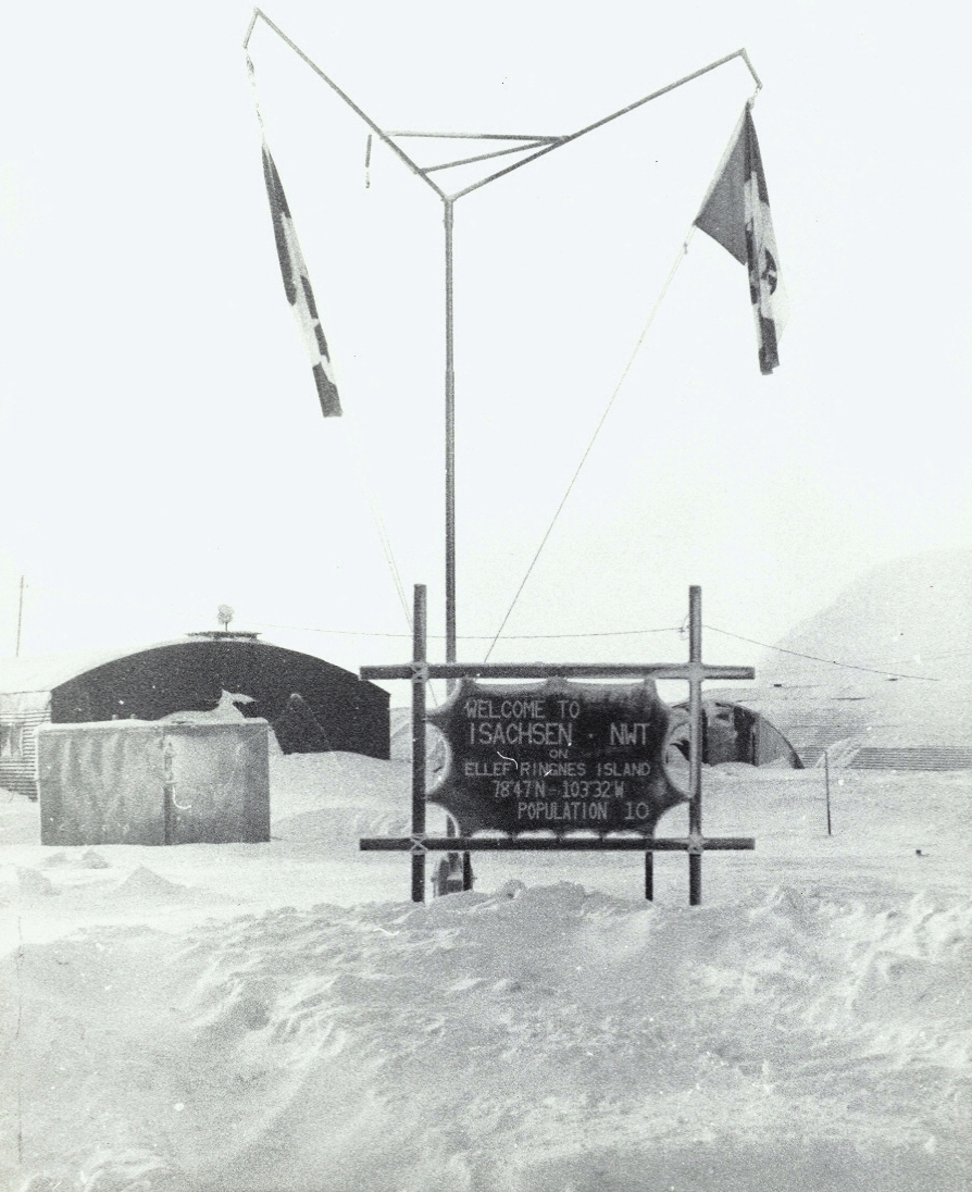
Isachsen is a remote Arctic research-weather station named after the Norwegian explorer of the Arctic Gunnar Isachsen. It is on the western shore of Ellef Ringnes Island in the Sverdrup Islands, in the territory of Nunavut in Canada. Isachsen Station was established to participate in a joint Canadian-American weather observation program. Isachsen Station operated from April 3, 1948, through September 19, 1978. Regular weather observations began on May 3, 1948. In October 1949, a Douglas C-47 Skytrain (tail number 316062) crash-landed near the station. No one was killed, but three on board were injured. The wreckage has been preserved by the cold weather and dry conditions.

Key Information

Climate

[edit]

According to Environment and Climate Change Canada, Isachsen and the surrounding area has the worst weather in Canada with a Climate Severity Index of 99 out of a possible 100.[2] The climate of Isachsen is a severe tundra climate, with short, cool summers and long, cold winters. The record high is 22.2 °C (72.0 °F) on July 21, 1962, and the record low is −53.9 °C (−65.0 °F) on March 16, 1956.

Climate data for Isachsen, 1951–1978 normals, extremes 1948–1978
Month Jan Feb Mar Apr May Jun Jul Aug Sep Oct Nov Dec Year
Record high °C (°F) −1.5
(29.3)
−4.4
(24.1)
−8.3
(17.1)
−1.1
(30.0)
6.1
(43.0)
16.7
(62.1)
22.2
(72.0)
14.4
(57.9)
3.9
(39.0)
0.0
(32.0)
−3.9
(25.0)
−8.9
(16.0)
22.2
(72.0)
Mean daily maximum °C (°F) −31.0
(−23.8)
−33.2
(−27.8)
−31.1
(−24.0)
−21.8
(−7.2)
−9.0
(15.8)
1.3
(34.3)
5.7
(42.3)
3.1
(37.6)
−5.9
(21.4)
−15.6
(3.9)
−24.7
(−12.5)
−29.2
(−20.6)
−15.9
(3.3)
Daily mean °C (°F) −34.7
(−30.5)
−36.6
(−33.9)
−34.7
(−30.5)
−25.7
(−14.3)
−12.0
(10.4)
−0.9
(30.4)
3.2
(37.8)
0.9
(33.6)
−8.8
(16.2)
−19.4
(−2.9)
−28.4
(−19.1)
−32.8
(−27.0)
−19.2
(−2.5)
Mean daily minimum °C (°F) −38.4
(−37.1)
−40.0
(−40.0)
−38.1
(−36.6)
−29.5
(−21.1)
−15.0
(5.0)
−3.1
(26.4)
0.6
(33.1)
−1.3
(29.7)
−11.6
(11.1)
−23.1
(−9.6)
−32.0
(−25.6)
−36.3
(−33.3)
−22.3
(−8.2)
Record low °C (°F) −52.8
(−63.0)
−53.3
(−63.9)
−53.9
(−65.0)
−45.6
(−50.1)
−29.4
(−20.9)
−15.6
(3.9)
−7.2
(19.0)
−13.3
(8.1)
−29.4
(−20.9)
−41.1
(−42.0)
−47.2
(−53.0)
−52.2
(−62.0)
−53.9
(−65.0)
Average precipitation mm (inches) 3.4
(0.13)
2.6
(0.10)
2.8
(0.11)
5.2
(0.20)
9.9
(0.39)
9.2
(0.36)
20.7
(0.81)
23.2
(0.91)
17.9
(0.70)
11.5
(0.45)
4.4
(0.17)
2.8
(0.11)
113.6
(4.47)
Average rainfall mm (inches) 0.0
(0.0)
0.0
(0.0)
0.0
(0.0)
0.0
(0.0)
0.0
(0.0)
2.8
(0.11)
15.2
(0.60)
14.6
(0.57)
1.2
(0.05)
0.0
(0.0)
0.0
(0.0)
0.0
(0.0)
33.8
(1.33)
Average snowfall cm (inches) 3.3
(1.3)
2.6
(1.0)
3.0
(1.2)
5.3
(2.1)
10.7
(4.2)
6.3
(2.5)
5.0
(2.0)
8.1
(3.2)
17.7
(7.0)
12.1
(4.8)
4.4
(1.7)
2.8
(1.1)
81.3
(32.0)
Average precipitation days (≥ 0.2 mm) 5 4 4 6 10 7 9 12 13 10 5 4 89
Average rainy days (≥ 0.2 mm) 0 0 0 0 0 2 6 6 0 0 0 0 14
Average snowy days (≥ 0.2 cm) 5 4 4 6 10 6 3 6 13 10 5 4 76
Mean monthly sunshine hours 0.0 0.3 94.6 324.3 338.6 266.6 232.0 143.4 50.0 7.1 0.0 0.0 1,456.9
Source: Environment and Climate Change Canada[3][4][5][6]

Flora and fauna

[edit]

There are no trees or shrubs that can live this far north. The plant life here is limited to small patches of moss, lichens, and a few tiny flowering plants. The wildlife here is limited to polar bears, Arctic foxes, caribou, Arctic hares, lemmings, seals, muskoxen, and migratory birds.

History and background

[edit]

On October 9, 1949, a C-47 cargo plane of the United States Air Force crashed on takeoff at the weather station. The plane had ten people on board: a US Air Force crew of six and four civilian passengers. The passengers were two U.S. weather bureau employees, a Canadian weather bureau employee, and a Royal Canadian Mounted Police constable. Three of the aircrew received cuts and bruises and everyone else escaped injury. The subsequent investigation blamed the accident on the plane being overloaded and attempting to take off with ice building up on the cockpit windshield and wings. At the time of the crash, there were 130 mm (5 in) of snow on the mud runway, a light snowfall and some fog.[7] The wreck was briefly shown in the Polar Special episode of the BBC program Top Gear. Photos of the remains of Isachsen Station can be seen on the Hilux Arctic Challenge website,[8] taken by the Top Gear team on their trip to the nearby 1996 North Magnetic Pole. The footage of the wreck was filmed on May 2, 2007. The episode first aired on July 25, 2007. The wreck site is located at 78°46′13″N 103°20′08″W / 78.77028°N 103.33556°W / 78.77028; -103.33556 (C-47 wreck, Isachsen).[9]

During the 1950s, Isachsen Station was primarily collecting radiosonde observations. Along with weather soundings from similar stations such as Mould Bay, Eureka, and Alert, this information was used to complete the North American data, primarily used to produce weather forecasts over the North Atlantic Ocean, Greenland, and Iceland, and long-range weather forecasts for Western Europe.

The Isachsen Station was in an extremely isolated place, with supplies and new personnel flown in by the Royal Canadian Air Force, usually twice a year: in the late spring, and again in the early fall from an air base (now Resolute Bay Airport) at Resolute on Cornwallis Island. In turn, Resolute Station, like most northern communities, was supplied using ocean-going cargo ships aided by icebreakers during the late summer sealift.

The eight-man staff at Isachsen usually consisted of four Americans and four Canadians. The Americans were usually two weather observers, a cook, and a mechanic. The Canadians were usually two weather observers and two radio operators. All communication to and from Isachsen Station was via shortwave radio radiotelegraphy.

Fuel oil and diesel fuel for heating and cooking, and for the station's electric generators, respectively, were shipped to Isachsen by transport planes in standard metal fuel barrels.

During the summer of 1958, the Isachsen station was rebuilt using prefabricated buildings that had been airlifted in along with about a dozen construction personnel. The sun sets in October and it is totally dark for about three months with temperatures from −32 to −51 °C (−26 to −60 °F). In the summer, the sun is visible above the horizon 24 hours a day for about three months with temperatures from about 7 to 16 °C (45 to 61 °F).

In 1956, a plan by the Government of Canada to resettle the Inuit at several high Arctic locations was scrapped. These settlements would have included Isachsen, Alert, Eureka, and Mould Bay.

On October 31, 1971, the United States withdrew from participation in the weather program at the site. In 1971, the Canadian government made a significant investment in Isachsen to upgrade its buildings. Then, in 1978, as a cost-cutting measure, the government decided to close one high Arctic station; Isachsen Station was selected, and it was closed down during that same year. The last manned weather observations were taken on July 31, 1978. An Automated Surface Observing System was placed at the site in 1989, linked by satellite communications to southern Canada. Isachsen is now uninhabited.

During the summers of 1989 and 1992, the closed weather station at Isachsen was the site of the High Arctic Psychology Research Station (HAPRS). The HAPRS operated under the aegis of the Polar Psychology Project, an international and transpolar multi-year program. Each time, six or seven researchers used each other as participants in investigations of the effects of isolation, remoteness, and cold on psychological and physiological processes such as taste perception, irritability, mood, subjective and hormonal measures of stress, brain waves, and sleep patterns. In 1992, a survey was made of abandoned vehicles, fuel drums, and potential contaminants to assist Environment and Climate Change Canada in planning to remove such items from the site.

See also

[edit]

References

[edit]
[edit]
Revisions and contributorsEdit on WikipediaRead on Wikipedia
from Grokipedia
Isachsen is a remote weather station located on the western shore of Ellef Ringnes Island in the Queen Elizabeth Islands of , . Established on April 3, 1948, as the third site in a joint Canadian-United States weather observation program known as the Joint Arctic Weather Stations (JAWS), it provided essential meteorological data from one of the planet's most extreme environments, characterized by a Canada Site Index (CSI) rating of 99 out of 100 for harshness. The station's last manned operations ended on July 31, 1978, with permanent closure on September 19, 1978, due to budget constraints; an automated surface observing system was installed in 1989 and continues to provide unmanned data via satellite, though the site remains uninhabited with derelict structures. Named in honor of the Norwegian polar explorer Gunnar Isachsen, who contributed to early mapping expeditions, the site exemplifies post-World War II international cooperation in high-latitude scientific research amid geopolitical interests. The station's establishment was driven by the need for improved to support transpolar routes and military operations in the , with personnel enduring isolation, subzero temperatures averaging -20°C annually, and limited resupply. Over its three decades, Isachsen recorded vital data on atmospheric conditions, contributing to broader understandings of climate patterns, though its remote position—approximately 800 miles from the —posed significant logistical challenges, including a notable 1949 crash of a U.S. C-47 on its . Today, the derelict structures stand as a frozen , occasionally visited by expeditions that highlight its role in asserting in the High while underscoring the environmental and human toll of such outposts.

Geography

Location and Access

Isachsen is situated at 78°47′N 103°30′W on the western shore of Ellef Ringnes Island in the Queen Elizabeth Islands, , . The site lies within the archipelago, a northern subset of the Canadian . Positioned well north of the at 66°33′N, Isachsen is approximately 1,360 km farther north, calculated from the latitudinal span. The area has historical significance regarding Earth's magnetism, as the magnetic North Pole was located nearby in the early 1990s, at roughly 78.1°N 103.7°W in 1990. Access to Isachsen has always been challenging due to its isolation. Historically, the station was established and resupplied via ski-equipped aircraft airlifts from Resolute Bay, with initial personnel flown in by planes in 1948. Efforts to deliver supplies by icebreakers, such as U.S. Navy vessels, failed in the late 1940s and early 1950s owing to impenetrable barriers. Today, following the station's decommissioning in 1978, visits are restricted to research or exploratory expeditions using on the disused airstrip or helicopters from Resolute Bay, as no supporting infrastructure remains. Logistical barriers remain formidable, with the site approximately 510 km from the nearest community at Resolute Bay, demanding full self-sufficiency in , fuel, and survival gear for all operations. Surrounding persists for most of the year, limiting viable access windows to brief summer periods or specialized polar flights. These conditions, compounded by the harsh , require meticulous planning to mitigate risks during transit.

Physical Characteristics

The Isachsen site occupies a flat, low-lying on the western shore of Ellef Ringnes , with an elevation of approximately 20 meters above . The terrain consists primarily of undulating plains underlain by continuous , with gravelly, poorly drained soils derived from weathered sedimentary bedrock and featuring occasional rocky outcrops and formations such as non-sorted circles. These characteristics reflect the broader coastal plain landscape, marked by low relief and dissection by small streams in some areas. Geologically, the area is part of the Sverdrup Basin, characterized by sedimentary rock formations, including to shales, sandstones, and limestones that overlie the stable basement of the Canadian Arctic Archipelago. These strata, exposed in nearby domes and ridges like the Isachsen Dome rising to about 300 meters, indicate a history of marine and non-marine deposition in a rift-related basin setting, with local intrusions of and . The stable cratonic foundation contributes to the region's tectonic quiescence, preserving these sedimentary layers with minimal deformation. The site's abandoned infrastructure comprises remnants of various buildings from its operational period, including , laboratories, a main operations building, radar towers for meteorological support, and fuel storage facilities, many of which remain structurally intact but weathered by exposure. Rusted vehicles and are scattered around the area, alongside the wreckage of a aircraft that crash-landed nearby in October 1949 due to overload and icing conditions during takeoff. Surrounding the site are small lakes and ponds, including over two dozen shallow freshwater bodies typical of the high Arctic, as well as periglacial features like pingos—ice-cored hills formed in drained lake beds—and a landscape with sparse vegetation cover dominated by barrens and minimal plant communities.

Climate and Environment

Climatic Conditions

Isachsen is characterized by a (Köppen ET), classified as a due to its extremely low annual , typically under 150 mm and predominantly falling as snow. This arid condition arises from the region's high latitude and persistent cold, which limit moisture availability and . The low contributes to the barren landscape, with snow cover lasting up to 10 months of the year. Temperature extremes define the site's harsh environment, with an average annual of approximately -15°C to -19°C. Summers are brief and cool, featuring average temperatures around 3°C and daily highs rarely exceeding 5°C, while winters bring severe cold, with average lows reaching -40°C or below and occasional drops to -50°C. The record low of -53.9°C was recorded on March 16, 1956. These ranges reflect the influence of polar air masses and minimal solar heating during the short warm season. Persistent katabatic winds, descending from the interior ice caps, frequently reach speeds of up to 100 km/h, exacerbating the chill through factors and contributing to frequent whiteouts and fog that can reduce visibility to near zero for extended periods, sometimes weeks. Seasonal daylight variations are extreme, with continuous daylight () from late to late and lasting approximately three months from mid-November to mid-February. Additionally, seasonal in the stratosphere thins the , particularly in spring, increasing (UV) exposure at the surface by up to 20-50% compared to normal levels. This heightened UV influences environmental conditions, including subtle adaptations in local to enhanced radiation stress.

Flora and Fauna

The flora at Isachsen is typical of high polar desert tundra, consisting primarily of low-growing mosses, lichens, sedges, and dwarf shrubs adapted to extreme cold, , and a brief of approximately 40-60 days. No trees are present due to the continuous layer, which limits root development, and the short frost-free period that prevents woody growth beyond prostrate forms. A total of 49 have been documented on Ellef Ringnes Island, including sedges such as spp. and dwarf shrubs like (Arctic willow), which form mat-like communities in moist depressions and provide limited ground cover. Lichens are particularly diverse, with 119 recorded across the island, contributing to and in nutrient-poor soils. Fauna diversity is low, reflecting the harsh conditions and sparse vegetation, with approximately 10 mammal species and 15 bird observed. Terrestrial mammals include small herbivores like lemmings (Dicrostonyx spp.) and hares (Lepus arcticus), which graze on plants, and predators such as foxes (Vulpes lagopus) that rely on them for food; larger like (Rangifer tarandus pearyi), muskoxen (Ovibos moschatus), and polar bears (Ursus maritimus) occasionally visit the area. Migratory birds dominate in summer, with nesting including ptarmigan (Lagopus spp.), snow buntings (Plectrophenax nivalis), long-tailed jaegers (Stercorarius longicaudus), glaucous gulls (Larus hyperboreus), and various ducks; these birds exploit the brief emergence for feeding their young. Offshore in the adjacent Sverdrup Basin, marine mammals such as ringed seals (Pusa hispida) and beluga whales (Delphinapterus leucas) are present, though terrestrial ecosystems see limited interaction with them. The ecosystem's food web is simple and centered on primary producers like algae in ephemeral ponds and soil crusts, which support a limited insect fauna—including mites, springtails, and chironomid midges—that serves as prey for birds and small mammals. Invertebrates, with around 75 arthropod species noted near Isachsen, play a key role in decomposition and nutrient cycling despite low biomass. Human impacts were minimal during the station's operation, but post-abandonment debris, including abandoned structures and waste from 1978, now poses risks to habitats by altering microenvironments and potentially contaminating soil for sensitive tundra species.

History

Establishment and Early Operations

The Isachsen weather station was established on April 3, 1948, as the third site in the joint Canada- High Arctic Weather Stations (JAWS) program, a collaborative effort between the Canadian Meteorological Service and the Weather Bureau to expand meteorological observations in the polar region. Named after the Norwegian Arctic explorer Gunnar Isachsen (1871–1938), who led expeditions to and in the early , the station was positioned on the western shore of Ellef Ringnes Island in Nunavut's archipelago. The site's selection was driven by the need to track Arctic air masses and provide upper-air data essential for hemispheric , , and emerging defense initiatives, including support for the Distant Early Warning (DEW) Line radar network constructed in the 1950s. During , sparse weather coverage in the high had hindered transpolar , prompting postwar expansion under JAWS to assert while fulfilling mutual security interests; Isachsen filled a critical gap in observations over the central approaches. By , reconnaissance flights had confirmed the location's suitability, with flat terrain allowing for an airstrip and minimal interference from local . Initial setup involved joint Canadian and American teams transporting supplies and personnel via air from Resolute Bay, with the first three staff members arriving under U.S. air support to begin site preparation. Construction utilized prefabricated structures, including Quonset huts for living quarters and storage, alongside a combined meteorological observatory and radio room equipped with standard instruments such as anemometers for wind measurements and shelters for thermometers and barometers. Regular surface and upper-air observations started on May 3, 1948, marking the onset of continuous data collection despite the rudimentary facilities. A notable early incident occurred on October 9, 1949, when a U.S. Air Force C-47 aircraft crashed on the station's airstrip during a supply mission, leaving the wreckage abandoned due to the remote location. The establishment phase from 1948 to 1950 faced severe environmental hurdles, including extreme cold, prolonged darkness, and high winds that complicated logistics and construction in an area with no prior human infrastructure. The first full-year operation commenced in 1949, staffed by 8 to 12 personnel—typically weather technicians, radio operators, a cook, and a —who endured isolation with limited resupply flights and relied on for external contact. These early years laid the foundation for the station's role in JAWS, though budgetary constraints occasionally delayed expansions.

Peak Activity and Research

During its peak operational period in the and , the Isachsen maintained a staff of 8 to 10 personnel, including meteorologists, radio operators, mechanics, an officer-in-charge (OIC), and an (ExO). These individuals were responsible for round-the-clock operations, with meteorologists conducting surface observations and upper-air measurements, radio operators handling communications and data encoding, and mechanics maintaining equipment, vehicles, and the airstrip. The withdrew from the JAWS program at Isachsen on October 31, 1971, after which the station was operated solely by . For instance, in 1964–1965, OIC Larry Petznick oversaw a team that emphasized reliable data collection despite challenging conditions. The station's research centered on upper atmosphere studies through frequent radiosonde and pilot balloon (pibal) launches, which provided ionospheric critical for and military planning. Ozone monitoring and auroral observations were also key, with launches occurring multiple times daily to track atmospheric layers; failure rates remained low at under 5%, even amid high winds that occasionally burst . These efforts contributed essential to global weather models and civilian programs, while seismic and magnetic recordings supported broader geophysical research across the High Weather Stations network. In the 1970s, activities included ongoing upper-air observations, as exemplified by technician Doug Munson's year-long tour in 1974–1975, where surface and upper-air collection persisted despite extreme isolation. Notable events during this era highlighted the station's logistical demands and environmental hazards. In 1965, an case required an urgent evacuation delayed by 13 hours due to , underscoring resupply vulnerabilities via spring airlifts and fall airdrops. Dog teams facilitated local transport, including visits by patrols, aiding self-sufficiency in the remote setting. A 1975 encounter, resolved with assistance from hunters, illustrated wildlife risks during winter operations. Daily life at Isachsen was marked by profound isolation, with the nearest settlement over miles away and contact limited to monthly supply flights, fostering psychological strains such as during the 3.5-month . Personnel coped through entertainment like shortwave ham radio, movies, books, and improvised hockey games on the , while annual airdrops delivered essentials including and fuel. Winter temperatures often plunged to -49°F (-45°C), yet routines persisted, blending scientific duty with communal resilience in a confined, wall-less "."

Closure and Immediate Aftermath

The decision to close Isachsen was driven by budgetary constraints and the increasing availability of satellite-based weather observation technologies, which reduced the necessity for manned stations. Environment Canada announced the shutdown in 1977, following significant investments in facility upgrades that year, as part of a broader rationalization of high-cost remote outposts in the Canadian Arctic. The station ceased operations on September 19, 1978, marking the end of three decades of continuous manned activity. Evacuation of the final staff occurred via in the summer of 1978, with the typical eight-person crew—comprising meteorologists, technicians, and support personnel—transported out by aircraft due to the site's extreme isolation on Ellef Ringnes Island. Equipment and supplies were partially dismantled and removed where feasible, but logistical challenges in the harsh environment meant that much of the , including furniture, tools, and buildings, was left behind intact. In the immediate aftermath, the site was officially designated as abandoned by Environment Canada, with no formal environmental assessments conducted at the time amid the focus on fiscal efficiencies. Minor salvage efforts took place sporadically in the early 1980s to recover select items, though the remoteness limited comprehensive cleanup. By 1989, an automated was installed to continue basic data collection via satellite interrogation, signaling the shift to unmanned operations across the High Arctic Weather Stations network.

Legacy and Current Status

Scientific and Historical Significance

The meteorological data collected at Isachsen from 1948 to 1978 formed a critical part of long-term records, contributing to the understanding of polar weather patterns. These observations, including upper-air soundings, provided essential baseline data for forecasting and climatological research in remote polar regions. Geopolitically, Isachsen played a key role in bolstering North American defense during the by supplying vital weather information that supported and operations, including trajectories for missile tracking over polar routes. As part of the Joint Weather Stations (JAWS) program, the station symbolized early international between and the in science, with maintaining sovereignty while leveraging U.S. logistical support to establish a sustained presence in the region. Isachsen holds significant historical value as an emblem of mid-20th-century , embodying the challenges and ambitions of manned scientific outposts in extreme environments during the post-World War II era. Today, the abandoned site stands as a preserved artifact of these efforts, with buildings, equipment, and personal items frozen in time, offering insights into the daily lives and logistical feats of station personnel.

Modern Exploration and Cultural References

In the years following its closure, Isachsen has attracted sporadic visits from artists, filmmakers, and adventurers drawn to its preserved state as a relic of mid-20th-century operations. In 2016, Canadian artist aAron Munson traveled to the site with his father, Doug Munson, who had worked there as a weather technician in 1974–1975, to document the abandoned structures through , video, and installations. Munson's multimedia , Isachsen: Leaning Toward Darkness, portrays the station as a haunting "frozen ," capturing rusted machinery, personal artifacts, and the psychological isolation endured by its former inhabitants. This artistic exploration highlights the site's eerie intactness, with buildings and equipment left much as they were in 1978 due to the extreme cold. Scientific interest in Isachsen has focused on environmental assessments amid broader concerns over legacy contaminants from historical stations. In the , surveys in the Canadian High Arctic examined potential from stored and , revealing risks of and hydrocarbons leaching into soil and water as thaws. Although no large-scale remediation had occurred at Isachsen specifically prior to 2025, these studies underscore the site's vulnerability, with derelict fuel drums and vehicle remnants posing contamination hazards if exposed by warming temperatures. As of 2025, the has initiated remediation efforts at the Isachsen High Arctic Weather Station (HAWS), including a waste fuel reduction program scheduled for late June to early August 2025, to address legacy contaminants. The station gained wider visibility through media portrayals, notably in the 2007 BBC Top Gear Polar Special, where presenters , , and explored the ruins during their journey to the magnetic , showcasing the abandoned buildings and a nearby crashed C-47 aircraft from 1949. More recent expeditions, such as a 2024 team visit documented by explorers, emphasize the site's role in illustrating abandonment, with drone footage enabling virtual tours for remote audiences. Isachsen has appeared in media symbolizing human impermanence in extreme environments and the encroaching threats of . Preservation efforts remain limited, with no formal active protection despite its historical value; Nunavut's territorial government recognizes it as an official locality but has not designated it a protected heritage site. Concerns over melting , which has accelerated across the High , threaten the site's stability, potentially destabilizing structures and releasing buried contaminants into local ecosystems. Occasional guided charter tours from Resolute Bay allow limited access for researchers and tourists, but future archaeological studies could provide deeper insights into outpost life, provided climate risks are mitigated.

References

Add your contribution
Related Hubs
User Avatar
No comments yet.