_with_labels.svg/250px-Map_of_the_N2_(South_Africa)_with_labels.svg.png "N2 (South Africa)")
_with_labels.svg/2000px-Map_of_the_N2_(South_Africa)_with_labels.svg.png)
Community hub
Recent from talks
Contribute something
Nothing was collected or created yet.
N2 (South Africa)
View on Wikipedia
 | ||||
|---|---|---|---|---|
_with_labels.svg) | ||||
| Route information | ||||
| Maintained by SANRAL, City of Cape Town Metropolitan Municipality[1] | ||||
| Length | 2,255 km (1,401 mi) | |||
| Major junctions | ||||
| West end | ||||
| East end | ||||
| Location | ||||
| Country | South Africa | |||
| Provinces | ||||
| Major cities |
| |||
| Highway system | ||||
| ||||
The N2 is a national route in South Africa that runs from Cape Town through George, Gqeberha, East London, Mthatha, Port Shepstone and Durban to Ermelo.[2] It is the main highway along the Indian Ocean coast of the country. Its current length of 2,255 kilometres (1,401 mi) makes it the longest numbered route in South Africa.[3]
Prior to 1970, the N2 designation only applied to the route from Cape Town to Durban.[4]
There are plans to realign the N2 national route from Port Shepstone to Mthatha along a shorter stretch of road that passes through Port Edward, Lusikisiki and Port St. Johns.[5][6][7] The project was initially scheduled for completion in 2024 and is expected to reduce the length of the route by 85 kilometres (53 mi).[8][9] Combined with the existing N2 route from Mthatha to East London, the realigned route will form the Wild Coast Toll Route.[5][6][7][10]
Route
[edit]
Western Cape
[edit]Cape Metropole
[edit]
The N2 begins in central Cape Town at the northern end of Buitengracht Street (M62), outside the entrance to the Victoria & Alfred Waterfront. The first section of the N2 is shared with the beginning of the N1; it is a four-lane elevated freeway that runs along a strip of land between the city centre and the Port of Cape Town. On the eastern edge of the city centre the two roads split, and the N2 turns south as Nelson Mandela Boulevard (formerly Eastern Boulevard), crossing above the yards and approach tracks of Cape Town railway station.
Leaving the Central Business District (CBD), the N2 descends to ground level after the R102 Christiaan Barnard on-ramp in Woodstock. Continuing roughly east-southeast, the N2 intersects a few roads in the Woodstock area, most notably Roodebloem Road, which provides access to the M4 Main Road and University Estate, located on the north-western slopes of Devil's Peak. After leaving the Woodstock area, the N2 meets the M3 Phillip Kgosana Drive, from the southern City Bowl. Atop Mowbray Ridge in Observatory, these two roads merge into a massive 9-lane highway and bend around the University of Cape Town Medical Campus and Groote Schuur Hospital before splitting at the bottom of the ridge, with the M3 running toward the University of Cape Town and the Southern Suburbs. This intersection, called Hospital Bend, was the scene of frequent bottlenecks and accidents due to the lack of pre-selection lanes. However, this stretch of road has been extensively upgraded and made safer.[11]
After Hospital Bend, the N2 heads east as Settler's Way and forms the border between Observatory and Mowbray, intersecting the M4 Main Road (westbound only), M57 Liesbeek Parkway, M5 Black River Highway, and Raapenberg Road. After leaving the Southern Suburbs, the N2 travels across the Cape Flats as a six-lane freeway towards Somerset West. It travels just past the southern end of the main runway at Cape Town International Airport and crosses the M7 and R300 highways (both of which link the N2 with Mitchells Plain in the south and Bellville and Brackenfell in the north). After the R300, the N2 becomes a four-lane freeway, passing nearby Khayelitsha and Macassar. It enters the Helderberg region where it passes through Somerset West and ceases to be a freeway after the R44 intersection, which links the N2 with Stellenbosch and the Winelands in the north. Here it passes through several intersections with traffic lights, which cause frequent congestion. After Somerset West, it bypasses Strand, Gordon's Bay, and Sir Lowry's Pass Village.
Overberg
[edit]After Sir Lowry's Pass Village, the N2 climbs Sir Lowry's Pass to enter the Overberg region. It passes near the town of Grabouw on the Hottentots-Holland plateau before descending the Houwhoek Pass to Botrivier. It then passes across the agricultural plains through the towns of Caledon, Riviersonderend, Swellendam and Riversdale to re-approach the coast at Mossel Bay, which marks the beginning of the Garden Route.
Garden Route
[edit]Just west of Mossel Bay, the N2 again becomes a divided freeway, and remains one as far as the intersection with the N9/N12 just outside George. From there, it travels across Kaaiman's Pass to Wilderness and on to Knysna and Plettenberg Bay. After Plettenberg Bay, a section of the road is tolled as the Tsitsikamma Toll Route, primarily because of the Bloukrans Bridge (crossing the Bloukrans River). An alternative route (part of the R102) used to run through Nature's Valley but this was closed in November 2007 after flood damage.[12] The Bloukrans Bridge marks the border with the Eastern Cape.

Eastern Cape
[edit]Sunshine Coast Road
[edit]After crossing the Bloukrans Bridge, the N2 becomes the Sunshine Coast Road, passing through the Southern edge of the Tsitsikamma Nature Reserve, and regains freeway status between Nompumelelo and Witsiebos. It runs eastward as a two-lane single carriageway highway, bypassing the resort towns of Jeffreys Bay and St. Francis Bay, as well as the town of Humansdorp. It becomes a four-lane dual carriageway freeway at the Van Stadens Bridge, which marks its entrance into the Nelson Mandela Bay Municipality.[13] It proceeds eastwards to the city of Gqeberha (formerly Port Elizabeth).
Nelson Mandela Bay
[edit]After the Van Stadens Bridge, the N2 meets the R102, which provides access to KwaNobuhle and Kariega (formerly Uitenhage) via the R334. It then enters Gqeberha as a four-lane dual carriageway freeway. It runs eastward past the suburbs of Kabega Park and Tulbargh before making a north-easterly turn just after the R102 Kragga Kamma Road/Cape Road intersection in More Grove. It then bypasses the suburbs of Newton Park and Korsten before meeting the R75 at the Commercial Road Intersection, with the R75 linking to the Gqeberha city centre in the south and to Kariega and Graaff-Reinet in the north.
It then passes through northern Sidwell, intersecting the M8 Kempston Drive (which links with the New Brighton and KwaZakhele suburbs in the north), and the M4 Settlers Way Highway (which links the N2 with the CBD and Chief Dawid Stuurman International Airport in the south and the industrial areas of Deal Party in the north). The N2 then leaves the city of Gqeberha running northwards towards Colchester, adjacent to the Indian Ocean, first passing across the estuarine area of the Swartkops River before passing through Bluewater Bay. After Bluewater Bay, it meets the R335 (which provides access to Motherwell) and bypasses the Coega Special Economic Zone (SEZ), with a major intersection with Neptune Road linking the harbour with the N2. It loses freeway status after the R334 Addo South Gate intersection, and becomes a two-lane single-carriageway highway after passing through Colchester.
Colchester - Qonce
[edit]After Colchester, the N2 leaves the Nelson Mandela Bay Metropolitan Municipality and turns north-eastwards, meeting the southern terminus of the N10 (which heads northwards towards Middelburg) and the western terminus of the R72 (an alternative route to East London) before moving away from the coast towards Makhanda.
After passing around Grahamstown (also known as Makhanda) on a bypass, the N2 passes through the former Ciskei, including Peddie, to enter the Buffalo City Metropolitan Municipality.
Buffalo City (Qonce- East London)
[edit]At Qonce (King William's Town) in Buffalo City, it meets the R63 and after several traffic-light intersections, the N2 turns east-south-east towards the coast, meeting it at East London.
The N2 becomes a four-lane dual carriageway road after leaving Qonce, and regains freeway status at the La Rochelle Street intersection in Berlin, just outside East London. It runs past Fort Jackson and the Mdantsane township. It then enters the city of East London as it passes to the north of Amalinda. After the M4 Amalinda Main Road intersection, it runs north of Vincent, intersecting the M1 Western Avenue (which links the CBD to the outlying rural areas situated along the Nahoon River). It then descends into the Nahoon River Valley, meeting the southern terminus of the N6 and the eastern terminus of the R72 after just crossing the Nahoon River. The N2 then passes through Beacon Bay, partially intersecting the M8 Beacon Bay Road, and exits the city of East London before bypassing Gonubie to the north of the city. The N2 then becomes a two-lane single-carriageway highway after the R102/M10 Main Road intersection (Gonubie Interchange), which is also the proposed start of the Wild Coast Toll Road.[14] It then continues as a freeway until shortly after the R102 Brakfontein intersection, after which it leaves the Buffalo City Metro.
Former Transkei
[edit]After East London, the N2 turns again towards the interior in a northeasterly direction to avoid the difficult terrain of the Wild Coast. It passes through the former Transkei and its former capital, Mthatha, where it meets the R61 route (an alternative route to Port Shepstone). There are plans for the N2 to run as a four-lane dual carriageway highway from Viedgesville to the Ngqeleni Village turn off, bypassing Mthatha to the south, and then continuing eastwards on the R61, as part of the N2 Wild Coast Toll Road.[15] After passing Mthatha, the N2 continues north-east through the towns of Qumbu, Mount Frere (KwaBhaca) and Mount Ayliff. Near Kokstad, the N2 climbs Brook's Nek to enter the province of KwaZulu-Natal.[16]
KwaZulu-Natal
[edit]Brooks Nek - Port Shepstone
[edit]The N2 enters KwaZulu-Natal atop Brooks Nek, after which it bypasses Kokstad to the south and meets the R56 from Matatiele. The N2 and the R56 are co-signed for 43 kilometres (27 mi) eastwards until which the R56 splits from the N2 at Stafford's Post. The N2 then runs east-south-east past the rural towns of Harding and Izingolweni (eZinqoleni), to enter Port Shepstone from the west through its suburb of Marburg, meeting the eastern terminus of the R61 highway (an alternative route from Mthatha) at the Oribi Toll Plaza (Marburg Interchange). This interchange with the R61 is to be the eastern end of the N2 Wild Coast Toll Route from East London via Mthatha and Port Edward.
Port Shepstone - Durban (South Coast Highway)
[edit]The N2 then turns to the north at the Oribi Toll Plaza to become the South Coast Highway (taking over from the R61), first running as a dual carriageway freeway for 4 km (2.5 mi), then losing dual carriageway status after the Umtentweni off-ramp (where it ceases to be a toll road), before regaining dual carriageway status just after Hibberdene. It passes through the rural areas of Southern KwaZulu-Natal, with the rural towns of Mthwalume, Umzinto and Dududu, and the resort towns of Pennington, Park Rynie and Scottburgh lying to the west and east of the N2, respectively.
eThekwini Metropolitan Area (Durban)
[edit]

The N2 enters the eThekwini Metropolitan Area 60 km (37 mi) south of Durban as a dual carriageway freeway just north of Scottburgh. It runs past the towns of Umkomaas (eMkhomazi) and Umgababa, before entering the built-up urban area of eThekwini at Kingsburgh and Amanzimtoti. It runs past Isipingo and the old Durban International Airport, before meeting the southern terminus of the M4 freeway at Umlazi; with the M4 providing access to the Durban CBD. After the M4 interchange, the N2 runs as an eight-lane dual carriageway freeway around the city of Durban known as the Outer Ring Road, bypassing the suburbs of Mobeni, Chatsworth, Sarnia, Ridgeview and Chesterville, with the M1 Higginson Highway intersection and the M7 Solomon Mahlangu Drive interchange providing access to these suburbs as well as the town of Queensburgh.
After leaving Chesterville, the N2 meets the N3 highway at the EB Cloete Interchange (locally known as Spaghetti Junction) at Westville. It then passes through the suburbs of Clare Hills and Reservoir Hills, meeting the M19 Umgeni Drive at a large intersection just outside of Reservoir Hills. It then continues northwards past Parlock, Riverhorse Valley, Briardene and Sea Cow Lake, with the M43 Queen Nandi Drive and the R102 KwaMashu Highway providing access to these places, thereafter exiting the city of Durban and continuing towards Mount Edgecombe and uMhlanga, meeting the M41 at the Mount Edgecombe Interchange where the Durban Outer Ring Road ends.
It then runs to the east of Verulam and to the west of eMdloti (formerly Umdloti), passing by the King Shaka International Airport in La Mercy (where the M65 provides access). The airport off-ramp marks the beginning of the KwaZulu-Natal North Coast Toll Road. After the airport, it is tolled at oThongathi (formerly Tongaat) before leaving eThekwini.
North Coast Highway
[edit]After eThekwini, the N2 runs toward Mtunzini, passing through Ballito before being tolled again at the Mvoti Toll Plaza before KwaDukuza (formerly Stanger). It meets the R74 near KwaDukuza. It then continues as a four-lane single carriageway highway and passes through sugar cane plantations on the KwaZulu-Natal North Coast. It is tolled for the final time at Mtunzini and meets the R34, which provides access to Richards Bay to the east and Empangeni and Ulundi to the west. Just after the R34 off-ramp, the N2 ceases to be a dual carriageway and turns north, moving away from the coast into the heart of Zululand, where it bypasses Greater St Lucia Wetlands Park to the west (where the R618 provides access) and runs past the town of Mkuze before turning to the north-west and running close to the border of Eswatini, passing the town of Pongola.
Mpumalanga
[edit]After leaving Pongola, the N2 makes a direct line for Piet Retief (eMkhondo) and meets the R33 to be co-signed with it as the main road through the town centre before splitting 12 km north of the town. It then heads north-west to Ermelo, where it enters as Voortrekker Lane and terminates at a junction with the N11 (De Emigratie Street) in the town centre, just south of the N11's intersection with the N17.
The total length of the road is 2,255 kilometres (1,401 mi). Although the dual carriageway sections of the N2 are discontinuous, when combined — including segments such as Cape Town to Somerset West (44 km), George to Mossel Bay (51 km), Gqeberha (70 km), East London (43 km), Port Shepstone (7 km), Hibberdene to KwaDukuza (165 km), and Mtunzini Toll Plaza to Richards Bay (35 km) — the N2 technically has the longest total length of dual carriageway among South African national roads.[3]
Toll Plazas
[edit]Toll plazas on the N2 include:[17]
Tsitsikamma Toll Route
[edit]- Tsitsikamma Toll Plaza, near Nature's Valley (includes ramp toll plazas)
South Coast Toll Route
[edit]- Oribi Toll Plaza, Port Shepstone (includes ramp toll plazas)
- Izotsha Ramp Toll Plaza, Shelly Beach
- Umtentweni Ramp Toll Plaza, Port Shepstone
North Coast Toll Route
[edit]- King Shaka Ramp Toll Plaza, near King Shaka International Airport
- oThongathi Toll Plaza, near oThongathi (includes ramp toll plazas)
- Mvoti Toll Plaza, near KwaDukuza
- Mandini Ramp Toll Plaza, near Mandini
- Dokodweni Ramp Toll Plaza, Dokodweni (near Gingindlovu)
- Mtunzini Toll Plaza, Mtunzini (includes ramp toll plazas)
Disruption to route
[edit]Heavy rains in 2006 triggered a mud-slide on the Kaaiman's pass section of the N2 between George and Wilderness. This caused the road to be temporarily closed from 26 August. As a result of the slide, a section of roadway sagged and large cracks appeared on the road surface. After an inspection by a team of engineers a single lane was reopened on 29 August for vehicles with a gross mass of under 5,000 kilograms (11,000 lb).
An alternative route following the Saasveld road was put into use, but this road only allows for a single lane of traffic and light vehicles. Heavy vehicles have to take an alternative route via the R62 and Langkloof pass effectively lengthening the distance from George to Wilderness from 11 to over 60 km (6.8 to 38 mi).[18] The road has since reopened.
Traffic on the N2 has also been disrupted on numerous occasions because of protests. On 10 September 2007, residents of Joe Slovo Informal Settlement blockaded the N2 Freeway in Cape Town near Langa. Police responded with rubber bullets, injuring over 30 residents.[19][20] On 4 December 2008, a few thousand residents of eMachambini, between KwaDukuza and Richards Bay in KwaZulu-Natal, blockaded the N2 Freeway in protest against the proposed AmaZulu World Themepark. Police opened fire and injured about 23 residents and arrested about 10.[21]
On 20 October 2012, a section of the N2 was closed after heavy rainfall caused a collapse about 20 km (12 mi) outside Grahamstown.[22]
On 5 November 2024 around 11h00, a section of the N2 was indefinitely closed due to a section of bridge partially collapsing on the southbound carriageway crossing the Embokodweni river next to the Amanzimtoti country club. One of the concrete bearings supporting the roadway failed, causing the surface of the southbound lanes to become uneven. The road closure has caused severe traffic disruptions into Amanzimtoti, Prospecton, Isipingo and the surrounding areas. Motorists travelling on the N2 southbound were being diverted onto the R102 and M35. It is also suspected that previous damage from the 2022 KwaZulu-Natal floods went undetected according to local officials.[23][24][25][26][27]
N2 Wild Coast Toll Route (N2WCTR)
[edit]There are plans to realign the N2 national route from Port Shepstone to Mthatha, on a shorter stretch of road, and designate the entire stretch from Port Edward through Mthatha to East London as a toll road.[28][29][30] The project was started in September 2016.[31] It was initially scheduled for completion in 2024 and this new N2 route will take over the entire section of the current R61 route from Port Shepstone to Mthatha,[32] with realignment between Port Edward and Lusikisiki (providing a shorter stretch of road between the two towns).[32]
This new route, known as the Wild Coast Toll Route (N2WCTR), will extend from East London (Gonubie Interchange) to Port Shepstone (Oribi Toll Plaza)[33] and extend further north-east through Park Rynie to the Isipingo Interchange, south of Durban.[33][10][8] There will be two new "greenfields" sections, one between Ndwalane (near Port St. Johns) and Lusikisiki, and the other between Lusikisiki and Port Edward. The latter greenfields section will provide a shorter and more direct route between Port Edward and Lusikisiki (via the Mtentu Bridge[34][35] and Msikaba Bridge[36][37]) while the current R61 passes through Flagstaff and Bizana on the route between the two towns. The greenfields sections will include two new toll plazas, namely the Mthentu Toll Plaza between Lusikisiki and Port Edward, and the Ndwalane Toll Plaza just outside of Port St. Johns.[29][30] There were also initially plans to place two toll plazas on the stretch from East London to Mthatha: the Ngobozi Toll Plaza just north of the Great Kei Bridge and the Candu Toll Plaza just north-east of Idutywa.[38] Plans to toll this section between East London and Mthatha have been cancelled.[39]
In this project, there are plans to widen the N2 from Port St. Johns to East London to a four-lane undivided highway. The new greenfields section between Lusikisiki and Port Edward will also include a four-lane undivided highway, with a four-lane dual carriageway through Lusikisiki. Bypasses around the towns of Butterworth (Gcuwa), Idutywa and Mthatha are to be constructed after the completion of the new toll road. According to Traveller24, this new route will be around 85 km (53 mi) shorter than the current N2 (and 69 km shorter than the current R61) and will be a faster route by about 3 hours for heavy vehicles (1½ hours for light vehicles).[8][9] Once this new 'Wild Coast Highway' is complete, the distance between Durban and East London will be reduced to 573 km (356 mi) and the overall route between Durban and Cape Town will be reduced to 1,621 km (1,007 mi), making the newer N2 the shorter route between Durban and Cape Town. The old N2 route passing through Harding, Kokstad and KwaBhaca would then be designated as the R102.[40]
The new greenfields sections in the Eastern Cape were categorized into seven packages.[41] Package 1 is from Ndwalane to Ntafufu, Package 2 is from Ntafufu to the Bambisana turn-off, Package 3 is from the Bambisana turn-off to Lingeni, Package 4 is from Lingeni to the Msikaba Bridge, Package 5 is from the Msikaba Bridge to the Mtentu Bridge, Package 6 is from the Mtentu Bridge to Kulumbe and Package 7 is from Kulumbe to the C. H. Mitchell Bridge.[41]

As of 2021, the road signs on the section of the R61 from Port Shepstone to Port Edward have already been changed to signs indicating the N2, indicating that this road from the Oribi Toll Plaza in Port Shepstone southwards will officially no-longer be designated as the R61.[42] Also, as of August 2024, parts of the road in the Eastern Cape are under construction,[43][36][37][44] including Package 4 and Package 5.[45][46] The Msikaba Bridge is expected to be completed by the end of 2025[47][37] while the Mtentu Bridge, after several delays, is expected to be completed by the end of 2027.[34][35][39]
Opposition and criticism
[edit]South Africa's national road agency, SANRAL, also initially planned to do some work on the existing 100 km (62 mi) section of the N2 highway from Port Shepstone to Durban[33][10] as part of this project, including installing toll plazas at Park Rynie[48][33] (midway between Port Shepstone and Durban; just north of the R612 off-ramp) and at Isipingo[48][33][49] (in the southern part of Durban; where the Durban Outer Ring Road begins). SANRAL received opposition from the eThekwini Metropolitan Municipality council as well as several businesses in the area over the proposed Isipingo Toll Plaza due to concerns over expenses for drivers in Durban South and traffic in the same area.[49][33][48] Those businesses also didn't want any toll plazas found within KwaZulu-Natal to be used to finance the construction of the new greenfields section of road (between Port St. Johns and the C. H. Mitchell Bridge), which is in a different province (Eastern Cape).[50] Several companies in the area, led by Toyota South Africa, took SANRAL to court, and the proposed Isipingo tollgate was cancelled.[51][52] The decision was made to scrap the plan to build any toll gate on the KwaZulu-Natal section of the Wild Coast Highway, which meant that the plan to construct a toll plaza at Park Rynie was also cancelled.[52][53]
The Amadiba Crisis Committee (ACC) has also expressed issues with the planned road and the Wild Coast region in which the road is to pass through, stating that it would divide the communal farming and grazing lands.[50] They advised SANRAL to reroute the proposed section between the C. H. Mitchell Bridge and the Mtentu Bridge inland, away from the coastline.[50] They held a protest in October 2024 at the Mtentu Bridge site.[54]
See also
[edit]- National Roads in South Africa
- The N2 Gateway Housing Project along the N2 freeway in Cape Town
References
[edit]- ^ N2/Settlers Freeway (“Hospital Bend”) Archived 2010-03-01 at the Wayback Machine
- ^ Falkner, John (May 2012). South African Numbered Route Description and Destination Analysis (Report). National Department of Transport. pp. 7–12. Archived from the original on 6 June 2014. Retrieved 27 January 2014.
- ^ a b "South Africa's Longest Roads". KH Plant. 16 January 2017. Retrieved 24 August 2021.
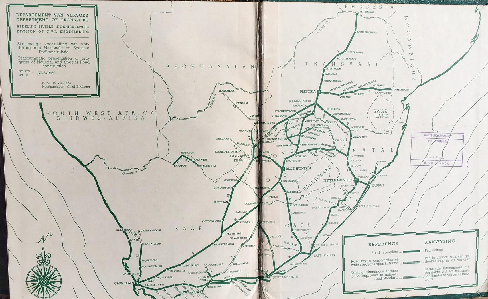
- ^ "Department of Transport (map)" (jpg). 30 June 1959. Retrieved 14 August 2023.
- ^ a b "@nuxtjs/Amp". Archived from the original on 7 June 2020. Retrieved 25 October 2020.
- ^ a b "Wild Coast toll road on track". DispatchLIVE. Retrieved 25 October 2020.
- ^ a b "N2 road project to continue". DispatchLIVE. Retrieved 25 October 2020.
- ^ a b c Etheridge, Jenna. "Court turns down N2 Wild Coast Road appeal". News24. Retrieved 25 October 2020.
- ^ a b SANRALauthor (30 March 2022). "Progress on the N2 Wild Coast Road". SANRAL Stop Over. Retrieved 23 July 2022.
- ^ a b c "Proposed N2 Wild Coast Toll Highway" (PDF). SAHRIS. October 2008. Retrieved 23 March 2025.
- ^ "N2/Settlers Freeway ("Hospital Bend")". 1 March 2010. Archived from the original on 1 March 2010. Retrieved 2 January 2022.
- ^ Rautenbach, Anje. "#4x4Adventure: What happened to the Bloukrans Pass? | News24". News24. Retrieved 24 August 2021.
- ^ Africa, Statistics South. "Local Municipality | Statistics South Africa". Retrieved 24 August 2021.
- ^ "social impact assessment of the proposed n2 wild coast toll highway". studylib.net. Retrieved 3 December 2021.
- ^ sizwesethu.futshane (2 June 2022). "SANRAL shares road construction plans with Mthatha, surrounding rural communities". SANRAL Stop Over. Retrieved 21 March 2023.
- ^ Roberts, Trygve. "Brook's Nek (N2) - Mountain Passes South Africa". mountainpassessouthafrica.co.za. Retrieved 2 February 2021.
- ^ "N2 Toll Fees". www.foresightpublications.co.za. Retrieved 11 February 2021.
- ^ news24.com story
- ^ "Cape Town: Police wade in on Joe Slovo shackdwellers blockade". labournet.
- ^ "N2 Gateway and the Joe Slovo informal settlement: the new Crossroads?". Abahlali.
- ^ "Cops break up protest over KZN development". Mail & Guardian. 5 December 2008.
- ^ "Section of N2 collapses in Eastern Cape | All ZA News". www.allzanews.com. Archived from the original on 16 January 2013. Retrieved 22 May 2022.
- ^ Subroyan, Anrisa (5 November 2024). "N2 Southbound bridge near Amanzimtoti partially collapses: alternate routes recommended". IOL. Retrieved 5 November 2024.
- ^ Rall, Se-Anne (5 November 2024). "Major traffic disruption on KZN south coast following N2 partial bridge collapse". IOL. Retrieved 5 November 2024.
- ^ Mthalane, Vusi (5 November 2024). "JUST IN: N2 bridge partially collapses near Twini Hill". The Citizen. Retrieved 5 November 2024.
- ^ TimesLive (5 November 2024). "N2 bridge collapse, one killed by lightning during KZN storm". Times Live. Retrieved 5 November 2024.
- ^ Nxumalo, Sakhiseni (5 November 2024). "Bridge collapse on N2 near Amanzimtoti causes severe traffic disruptions". News24. Retrieved 5 November 2024.
- ^ "@nuxtjs/Amp". Archived from the original on 7 June 2020. Retrieved 25 October 2020.
- ^ a b "Wild Coast toll road on track". DispatchLIVE. Retrieved 25 October 2020.
- ^ a b "N2 road project to continue". DispatchLIVE. Retrieved 25 October 2020.
- ^ "N2 Wild Coast Toll Road set to start". Bizcommunity. Retrieved 17 June 2025.
- ^ a b "Wild Coast Road project takes in highest bridge in Africa". The South African. 5 September 2020. Retrieved 25 October 2020.
- ^ a b c d e f "social impact assessment of the proposed n2 wild coast toll highway". studylib.net. Retrieved 3 December 2021.
- ^ a b Venter, Irma. "Much pricier Mtentu Bridge construction restarts five years after Aveng walkout". Engineering News. Retrieved 28 September 2023.
- ^ a b Leshoro, Dimakatso. "R4.05 billion Mtentu Bridge construction to finally get underway". City Press. Retrieved 28 September 2023.
- ^ a b Venter, Irma. "Msikaba bridge heads for completion by end-2024". Engineering News. Retrieved 28 September 2023.
- ^ a b c "SANRAL sets 2025 as deadline for Msikaba Bridge completion". SABC News. 29 April 2023. Retrieved 28 September 2023.
- ^ "Briefing Memorandum: Wild Coast Toll Road- South Africa" (PDF).
- ^ a b "Engineering News - N2 Wild Coast Toll Road megabridge projects, South Africa – update". Engineering News. Retrieved 20 November 2023.
- ^ "N2 Wild Coast | SANRAL". stop-over.co.za. Retrieved 8 November 2024.
- ^ a b SANRAL (18 November 2021). "N2 Wild Coast Road Update" (PDF). South African Road Federation. Retrieved 23 March 2025.
- ^ "Google Maps". Google Maps. Retrieved 28 September 2023.
- ^ Langa, Lungi (13 September 2021). "OUR BURNING PLANET: Sparks fly at meeting with rural community over proposed N2 Wild Coast toll road". Daily Maverick. Retrieved 3 August 2022.
- ^ "SANRAL surpasses goals on construction". News24. Retrieved 24 December 2023.
- ^ "Wild Coast N2 Highway Project Taking Shape". www.knightpiesold.com. Retrieved 23 March 2025.
- ^ FutshaneS (14 August 2024). "SANRAL announces new R2.2 billion project and Contractor Development Programme for N2 Wild Coast Road". SANRAL Stop Over. Retrieved 23 March 2025.
- ^ Channel, National Geographic. "Building Impossible with Daniel Ashville Microsite". www.natgeotv.com. Retrieved 10 October 2023.
- ^ a b c "Toll road opposed by Mkhize | Wild Coast". www.wildcoast.co.za. Retrieved 3 December 2021.
- ^ a b "Heavyweight team continues proposed N2 toll fight". South Coast Sun. 25 June 2014. Retrieved 3 December 2021.
- ^ a b c Carnie, Tony (26 June 2023). "Sanral's need for speed rides roughshod over Xolobeni/Amadiba community's land". Daily Maverick. Retrieved 24 December 2023.
- ^ "Wild Coast toll road goes ahead Wild Coast toll road gets the nod amid some opposition". News24. Retrieved 3 December 2021.
- ^ a b "KwaZulu-Natal (KZN) MEC for Transport, Community Safety and Liaison, Willies Mchunu, welcomes decision not to go ahead with Isipingo toll gate | South African Government". www.gov.za. Retrieved 25 September 2024.
- ^ Sapa. "Proposed Wild Coast toll road scrapped". Business. Retrieved 25 September 2024.
- ^ Brouwers, Terri-Ann (17 October 2024). "Construction on R4bn Mtentu Bridge project halted amid protests". Moneyweb. Retrieved 24 January 2025.
External links
[edit] Media related to N2 road (South Africa) at Wikimedia Commons
- N2 Wild Coast Toll Route Construction Updates


N2 (South Africa)
View on GrokipediaOverview
Route Summary and Length
The N2 is South Africa's longest national route, extending 2,255 kilometres from an interchange near Cape Town's docks in the Western Cape to Ermelo in Mpumalanga province. It primarily hugs the southern and eastern coastlines along the Indian Ocean, linking major population centers and ports while traversing diverse terrains including urban areas, coastal plains, and mountainous regions.[7][2] Key segments connect Cape Town to George via the Garden Route, then proceed through Gqeberha (formerly Port Elizabeth), East London, Mthatha, Port Shepstone, and Durban (eThekwini), before turning inland toward the N3 at Ermelo. This path supports freight and passenger movement between economic hubs, with the route's coastal alignment minimizing elevation changes in its southern portions compared to inland alternatives.[8][9] The total length reflects designations under the South African National Roads Agency (SANRAL), encompassing both freeway-standard sections and two-lane highways, with ongoing upgrades aimed at improving capacity and safety along high-traffic corridors.[2]Strategic and Economic Significance
The N2 national route constitutes a vital component of South Africa's freight and passenger transport infrastructure, linking major economic hubs along the southern and eastern seaboard from Cape Town to Durban and extending inland toward Mpumalanga. It supports the movement of goods critical to the national economy, with highways like the N2 and parallel N3 handling approximately 70% of South Africa's road freight traffic.[10] This connectivity underpins trade efficiency by providing direct access to key ports, including Cape Town, Ngqura (near Gqeberha), East London, and Durban, which serve as primary gateways for imports and exports, with Durban alone managing over 60% of the nation's container throughput.[11] Economically, the N2 facilitates regional development through projects such as the N2 Wild Coast Toll Road, which aims to establish a trade corridor along the south-eastern coast, enhancing access to underdeveloped areas in the Eastern Cape and stimulating sectors like agriculture, mining, and small-to-medium enterprises.[12] Upgrades to the route, including bridges like the Mtentu, which will rank among Africa's tallest upon completion, are projected to boost local economies by improving logistics reliability and reducing transport costs, thereby supporting South Africa's broader integration into African trade networks.[13] In KwaZulu-Natal, ongoing N2-N3 enhancements have generated thousands of jobs and alleviated congestion, directly contributing to provincial GDP growth estimated at over 33% national share in connected heartlands.[14][15] Strategically, the N2's role extends to tourism and resource extraction, with segments like the Garden Route driving visitor economies through scenic coastal access, while enabling efficient supply chains for industries reliant on port proximity. Government investments exceeding R18.5 billion in national roads, including N2 expansions as of 2025, underscore its priority for sustaining freight-dependent growth amid regional integration efforts.[16] These developments prioritize empirical enhancements in safety and capacity to mitigate bottlenecks that historically impede economic velocity.[17]History
Pre-1994 Development
The national road network in South Africa, including precursors to the N2 route, originated with the National Roads Act of 1935, which declared approximately 8,000 km of arterial roads for systematic improvement and maintenance under centralized provincial administration.[18] By 1961, 94% of the initial declared network had been surfaced or improved, reflecting steady post-World War II expansion driven by economic growth and vehicle ownership increases.[19] The N2's formal designation emerged as part of this system, initially limited to the coastal corridor from Cape Town to Durban prior to 1970, serving as a primary link between key ports and urban centers.[20] The National Road Act of 1971, effective October 1, 1971, introduced the modern numbering scheme and centralized oversight under the National Transport Commission, reclassifying and prioritizing routes like the N2 for high-standard construction.[21] Early N2 sections near Cape Town saw construction starting in the early 1950s, with the initial highway segment opening around 1962 to connect Cape Town to Paarl, establishing the foundation for southward extensions along the western edge of the route.[22] Significant upgrades accelerated in the 1970s and 1980s under the National Party government, focusing on dual-carriageway conversions and alignments to handle rising freight and tourist traffic.[21] This included major improvements from Cape Town to Port Elizabeth along the Cape coast and from the Umtamvuna River northward to Durban, enhancing connectivity to industrial hubs like East London and Richards Bay.[21] The Garden Route portion advanced with environmental mitigations, costing up to R100 million in period values for erosion control and habitat preservation.[21] A milestone in financing innovation came in 1983 with the opening of the Tsitsikamma Toll Road on the N2's Garden Route section between Storms River and Plettenberg Bay, South Africa's first toll pilot project at 13 km long, designed to test user-funded maintenance amid fiscal constraints.[21] Pre-1994 development emphasized white-designated areas and economic corridors, resulting in incomplete segments through Bantustan territories like Transkei, where the Wild Coast stretch remained largely gravel or bypassed, limiting overall continuity.[6] By the early 1990s, the N2 spanned roughly 1,800 km in its core coastal alignment, with over 70% of national routes upgraded to freeway standards in priority zones.[21]Post-Apartheid Upgrades and Expansion
Following the transition to majority rule in 1994, South Africa's national road network, including the N2, received renewed focus through the establishment of the South African National Roads Agency (SANRAL) in 1998, which assumed responsibility for maintenance, upgrades, and expansion to address deteriorating infrastructure, rising traffic volumes, and economic integration needs. Post-apartheid investments emphasized dual carriageways, safety enhancements, and new alignments to reduce travel times and accident rates, with funding partly from tolls and public-private partnerships amid fiscal constraints.[23] By 2025, SANRAL had completed or advanced several N2 projects totaling hundreds of kilometers, though progress was hampered by legal challenges, community protests over land use, and environmental concerns in rural sections.[6] A flagship initiative was the N2 Wild Coast Toll Road project, originally conceived in the 1970s but revived post-1994 to upgrade approximately 550 km between East London and the KwaZulu-Natal border, including new alignments through underdeveloped coastal areas to shorten routes and boost trade.[24] Valued at R28 billion as of 2025, the project incorporates dual carriageways, bridges, and toll plazas, with phases like the 17.3 km Majuba Hill section under construction since the early 2020s at a cost of R3.3 billion, targeting completion by August 2026 to enhance connectivity between the Eastern Cape and KwaZulu-Natal.[16] [25] Despite government assertions of public benefit for economic development, the effort has encountered opposition from local communities citing displacement risks and cultural site disruptions, leading to court delays since the 2010s.[26] In KwaZulu-Natal, upgrades focused on the South Coast and North Coast segments, including a 55 km dual-carriageway expansion from Lovu River to Umdloti River, incorporating interchange improvements and safety barriers to handle freight and tourism traffic.[5] Further, a 66 km stretch from Mtamvuna River to Hibberdene Interchange began planning for widening and geometric enhancements in 2025, projected for completion within three to five years.[27] The N2 Belstone Interchange near Bhisho opened in July 2024 after 33 months of construction, featuring elevated ramps and linking to local routes for improved urban access.[28] In the Eastern Cape, a 112 km section from East London toward the border underwent major resurfacing and bridge reinforcements by 2020s, while the Leiden to Camden segment progressed toward dual carriageways by November 2025, with 17.7 km of ancillary R336 road integrated.[29] [30] Western Cape efforts centered on urban freeway retrofits around Cape Town, where post-1994 works included re-grading under bridges, installation of median barriers, and ramp pre-selection lanes to mitigate weaving and congestion on high-volume approaches to the city.[31] These interventions, often tied to broader Gauteng-freeway-style models adapted locally, reduced accident hotspots but faced criticism for insufficient integration with public transport amid rapid urbanization.[32] Overall, N2 expansions post-1994 have increased the route's paved dual-lane coverage by over 200 km in key corridors, supporting GDP contributions from logistics, though maintenance backlogs persist due to funding shortfalls and vandalism.[5]Route Description
Western Cape Section
The Western Cape section of the N2 national route commences in Cape Town at its interchange with the N1 near the city centre, extending eastward approximately 450 kilometres to the provincial boundary with the Eastern Cape near the Bloukrans River bridge east of Plettenberg Bay.[33] This segment traverses diverse terrain, including urban suburbs, mountainous passes, agricultural plains, and coastal landscapes along the Indian Ocean.[34] From Cape Town, the N2 passes through the townships of Mitchells Plain and Khayelitsha before reaching Somerset West, where it begins the ascent of Sir Lowry's Pass (elevation 540 metres) through the Hottentots Holland Mountains, providing panoramic views of False Bay.[34] The route then descends into the Overberg region, skirting coastal towns such as Gordon's Bay and Kleinmond, and proceeding via Botrivier and Caledon to Swellendam, the Overberg's oldest town founded in 1747.[35] Beyond Swellendam, the N2 veers slightly inland before rejoining the coastal plain near Riversdale, continuing through Heidelberg, Albertinia, and Mossel Bay—a key port town approximately 385 kilometres from Cape Town.[33] The eastern portion aligns with the western extent of the Garden Route, passing George (the region's commercial hub) and extending through Wilderness, Sedgefield, Knysna (known for its lagoon and heads), and Plettenberg Bay, characterised by lagoons, indigenous forests, and beaches.[36] The entire section is fully paved and dual-carriageway in parts, particularly around urban areas and upgraded stretches like between George and Wilderness, though it features curves, overtaking lanes, and occasional single-lane sections in rural areas.[37] Traffic includes heavy vehicles, tourists, and local commuters, with the route serving as a vital artery for the province's tourism, agriculture, and freight transport.[38]Eastern Cape Section
The N2 enters the Eastern Cape from the Western Cape at the provincial border east of the Paul Sauer Bridge, spanning the Storms River, and immediately traverses the Tsitsikamma indigenous forest region, characterized by dense vegetation, steep gorges, and elevated bridges like the Bloukrans Bridge nearby, offering panoramic coastal views but requiring caution due to sharp curves and wildlife crossings.[25] The highway continues eastward for approximately 70 km to Jeffreys Bay, a renowned surfing hub with the Supertubes wave break, where the road features dual carriageways and interchanges facilitating access to local amenities.[39] From Jeffreys Bay, the N2 proceeds 60 km inland via Humansdorp, an agricultural center, to Gqeberha (formerly Port Elizabeth), the province's largest urban area and a key industrial port handling automotive exports and container traffic, with the route including multi-lane freeways, the John B. Momayovyo Drive bypass, and connections to the R75 and M4 for city access. Beyond Gqeberha, the N2 shifts northeast for 285 km to East London, passing through industrial zones like Coega, then inland via Kariega (Uitenhage) and Makhanda (Grahamstown), where it intersects the R67 at a trumpet interchange; this segment includes undulating terrain, partial dual carriageways, and sections prone to flooding, such as near the Fish River Pass, before reaching the Gonubie Interchange on East London's outskirts.[40] Northeast of East London, the 200 km stretch to Mthatha (Umtata) forms the initial part of the N2 Wild Coast corridor, a historically underdeveloped single-carriageway road winding through rural Transkei landscapes, river crossings like the Great Kei, and towns including Butterworth and Idutywa, plagued by potholes, overloading by heavy vehicles, and elevated crash rates due to inadequate alignment and maintenance.[41] From Mthatha, the route extends another 150 km eastward via Qumbu and Mount Frere to the KwaZulu-Natal border at the Mtamvuna River, incorporating ongoing SANRAL upgrades under the N2 Wild Coast Toll Highway project—initiated in phases since 2012—to four-lane standards with viaducts over the Msikaba and Mtentu rivers, aimed at reducing travel time from 9 hours to 5 hours between East London and the border while addressing geometric deficiencies and erosion risks.[42][43] These improvements, funded partly through tolls, have faced delays from legal challenges and terrain complexities but progressed with seven major packages completed or underway as of 2024.[44]KwaZulu-Natal Section
The N2 enters KwaZulu-Natal from the Eastern Cape near Kokstad, ascending Brook's Nek Pass before passing through the town of Kokstad. From Kokstad, the route heads southeast through Harding and Izingolweni, transitioning from inland terrain to the coastal South Coast Parkway near Port Shepstone. This section features dual carriageways in parts, with toll collection at the Oribi Toll Plaza south of Port Shepstone.[45] Northward from Port Shepstone, the N2 follows the coastline, serving tourist hubs such as Shelly Beach, Hibberdene, and Scottburgh, with interchanges for local access to beaches and resorts. The road maintains a four-lane configuration through Amanzimtoti, approaching Durban via the South Coast Toll Road, which spans approximately 170 km from the provincial border area to the city. Upgrades in this corridor, including from the Lovu River near Scottburgh, aim to expand capacity to reduce congestion for freight and tourism traffic.[46][5] In Durban, the N2 integrates with the Outer Ring Road, a partial freeway system bypassing the city center to connect the southern approach directly to the northern extension, facilitating flow around the urban core and port facilities.[47] The northern leg, known as the North Coast Toll Road, extends from Durban northward along the Dolphin Coast, passing Virginia Airport, Umhlanga Rocks, Mount Edgecombe, Tongaat, and Ballito amid suburban development and commercial zones. Further on, the route traverses sugar cane plantations and industrial areas near Mandeni and Isithebe, reaching the port of Richards Bay before continuing to Empangeni. The N2 then veers inland through rural Zululand, crossing the Pongola River to the Mpumalanga border near Pongola, totaling about 370 km from Durban to the provincial boundary. This segment supports heavy freight to ports and includes tolls managed by concessionaires for maintenance.[46][48][49]Mpumalanga Section
The Mpumalanga section of the N2 national route commences at the KwaZulu-Natal provincial border and proceeds northwest for approximately 106 kilometers to its terminus in Ermelo.[50] This segment primarily traverses the Gert Sibande District, passing through rural highveld landscapes characterized by grasslands and agricultural lands, with increasing industrial activity near Ermelo due to nearby coal mining operations. The route serves as a vital link for freight transport, connecting Mpumalanga's inland economy to export facilities at Richards Bay via KwaZulu-Natal.[51] Entering Mpumalanga from the southeast near the Usuthu River border crossing, the N2 first reaches eMkhondo (formerly Piet Retief), a key junction town where it intersects local roads facilitating access to surrounding timber and farming communities. From eMkhondo, the highway continues northwest, passing through areas like Bloemendal and the Panbult region before terminating in Ermelo at an interchange with the N11 national route, which extends further north toward Johannesburg.[52] [53] The South African National Roads Agency (SANRAL) has undertaken significant upgrades in this section to address capacity constraints and safety issues, including widening from a two-lane single carriageway to a four-lane divided dual carriageway. Notable projects include the improvement of Section 33 from the border (km 0) to Bloemendal (km 34) and beyond to eMkhondo (km 63.3), as well as Section 34 extending toward Camden. The Panbult interchange and adjacent 10.8 km stretch between eMkhondo and Ermelo were completed in 2025, enhancing traffic flow and reducing accident risks on this freight-heavy corridor.[54] [52] [55] These developments support economic growth by improving connectivity between Mpumalanga's resource sectors and coastal ports.[56]Toll System
Toll Plazas and Routes
The N2 national route in South Africa features toll plazas operated by the South African National Roads Agency (SANRAL), primarily along its Eastern Cape and KwaZulu-Natal sections to fund maintenance, upgrades, and operations on designated segments. These plazas support both cash and electronic tag payments, with vehicle classes determined by axle count. Tolls apply to mainline and ramp configurations, but no plazas exist on the Western Cape or Mpumalanga portions of the N2.[57][58] In the Eastern Cape, the Tsitsikamma Toll Plaza is the sole facility on the N2, located near Storms River approximately 70 km west of Gqeberha (Port Elizabeth) and east of Knysna, serving the coastal route between the Garden Route and the Eastern Cape interior.[58][59] KwaZulu-Natal hosts the majority of N2 toll infrastructure across two main corridors: the North Coast Toll Route, spanning from Durban northward toward Empangeni and Richards Bay, and the South Coast Toll Route, extending southward from Durban to Port Shepstone. The North Coast route includes plazas at oThongathi (Tongaat, with north and south ramps), Mvoti (near Ballito), Mtunzini, Mandini, and Dokodweni, covering dual-carriageway segments with frequent interchanges.[60][57][61] A ramp toll also operates at King Shaka International Airport access.[62] The South Coast Toll Route features plazas at Oribi (mainline and southern ramps south of Durban), Umtentweni (ramp near Hibberdene), and Izotsha (ramp at R61 junction near Shelly Beach), supporting traffic along the densely populated coastal corridor with high tourism volumes.[57][62][63]| Route Section | Key Toll Plazas | Province |
|---|---|---|
| Tsitsikamma | Tsitsikamma (mainline) | Eastern Cape |
| North Coast | oThongathi, Mvoti, Mtunzini, Mandini, Dokodweni; King Shaka Airport ramp | KwaZulu-Natal |
| South Coast | Oribi (mainline/ramp), Umtentweni (ramp), Izotsha (ramp) | KwaZulu-Natal |
Funding and Management
The funding for the N2 toll system is primarily managed by the South African National Roads Agency SOC Limited (SANRAL), a state-owned entity established under the South African National Roads Agency Limited and National Roads Act of 1998, which oversees the development, maintenance, rehabilitation, and tolling of national roads including tolled sections of the N2.[64] Toll revenues from designated plazas, such as those on the N2 Winelands Toll Road and the proposed N2 Wild Coast Toll Road, form the core funding mechanism, enabling SANRAL to finance upgrades and operations independently of general tax revenues, thereby accelerating infrastructure delivery compared to traditional public funding models.[59] [65] For non-toll segments, funding supplements include government grants, while toll projects increasingly rely on debt financing from capital markets and international lenders.[66] In July 2025, SANRAL secured a ZAR 7 billion (approximately USD 397.6 million) loan from the New Development Bank (NDB), a BRICS multilateral institution, specifically allocated to strengthen and improve toll corridors including sections of the N2 alongside the N1 and N3, with disbursements supporting modernization to reduce transport costs and enhance economic connectivity.[67] [68] This financing, approved in phases starting from 2019, underscores SANRAL's strategy of leveraging concessional loans for high-impact projects, with repayment tied to toll collections and project viability assessments.[69] For the N2 Wild Coast Toll Road, a 560 km upgrade initiative between East London and uMlalazi, funding is structured around tolling the greenfield and rehabilitated alignments to recover construction costs estimated in the billions of rands, with SANRAL as the implementing agency procuring via public-private partnerships where feasible.[70] [65] Management of the N2 toll operations involves SANRAL's centralized control over planning, procurement, and enforcement, including the rollout of a national Management Information System (MIS) across toll plazas to integrate billing, traffic monitoring, and revenue collection, with full implementation targeted within six years from 2021 tenders.[71] Daily operations, such as toll collection via electronic systems and cash lanes, are handled through contracted service providers under SANRAL oversight, ensuring compliance with the National Roads Act and addressing maintenance backlogs—evidenced by R4.1 billion spent on toll roads nationally in the 2023-24 financial year.[64] Challenges in funding recovery, including a reported R29 billion shortfall in toll payments for 2024/25 due to evasion and policy disputes like the Gauteng e-toll suspension, indirectly pressure N2 toll sustainability, prompting SANRAL to explore hybrid models blending tolls with alternative revenues.[72]Major Projects and Upgrades
Existing Toll Routes
The N2 highway features several toll plazas managed by the South African National Roads Agency (SANRAL), primarily along its KwaZulu-Natal segments to fund maintenance, upgrades, and debt servicing for high-volume coastal corridors. These include the designated N2 South Coast Toll Route and individual North Coast plazas, with one additional plaza in the Eastern Cape. Unlike open-road tolling systems elsewhere in South Africa, these operate as conventional barrier tolls, charging light vehicles fees ranging from R7.50 to R21 as of March 2025 adjustments.[58][48][62] The N2 South Coast Toll Route covers approximately 50 km from Port Shepstone northward toward Hibberdene, incorporating three main plazas: Izotsha (south ramp near Shelly Beach), Oribi (mainline near Port Shepstone), and Umtentweni (north ramp toward Hibberdene). Implemented in the early 2000s, this tolled section supports infrastructure improvements for the region's tourism-dependent economy and freight traffic, with annual revenues contributing to SANRAL's national road network obligations.[57][62] Further north, the N2 North Coast features toll plazas at oThongathi (mainline near Tongaat), Mvoti (mainline between Ballito and Stanger), and supporting ramps including King Shaka Airport access and Mandini south ramp. These plazas, operational since the mid-2010s alongside highway widenings to four lanes, address congestion on the Durban-to-Richards Bay artery, which handles over 50,000 vehicles daily in peak periods.[58][73][62] In the Eastern Cape, the Tsitsikamma Toll Plaza—situated 30 km west of Plettenberg Bay between Humansdorp and the Storms River bridge—represents the sole existing N2 toll outside KwaZulu-Natal. Established in 1980s to finance the engineering challenges of the mountainous Garden Route section, including bridges and cuttings through Tsitsikamma National Park, it collects fees for ongoing preservation of this vital link between Port Elizabeth and the Western Cape.[58][59]| Toll Plaza | Type | Location (Approximate Km from Cape Town) | Province |
|---|---|---|---|
| Tsitsikamma | Mainline | 750 km (near Storms River) | Eastern Cape |
| Izotsha | South ramp | 1,300 km (near Shelly Beach) | KwaZulu-Natal |
| Oribi | Mainline | 1,320 km (near Port Shepstone) | KwaZulu-Natal |
| Umtentweni | North ramp | 1,340 km (near Hibberdene) | KwaZulu-Natal |
| oThongathi | Mainline | 1,480 km (near Tongaat) | KwaZulu-Natal |
| Mvoti | Mainline | 1,520 km (near Stanger) | KwaZulu-Natal |