Hubbry Logo
Navajo SandstoneNavajo SandstoneMain
Open search
Navajo Sandstone
Community hub
Navajo Sandstone
logo
8 pages, 0 posts
0 subscribers
Be the first to start a discussion here.
Navajo Sandstone
Navajo Sandstone
from Wikipedia

The Navajo Sandstone is a geological formation in the Glen Canyon Group that is spread across the U.S. states of southern Nevada, northern Arizona, northwest Colorado, and Utah as part of the Colorado Plateau province of the United States.[2]

Key Information

Description

[edit]
The Permian through Jurassic stratigraphy of the Colorado Plateau area of southeastern Utah that makes up much of the famous prominent rock formations in protected areas such as Capitol Reef National Park and Canyonlands National Park. From top to bottom: Rounded tan domes of the Navajo Sandstone, layered red Kayenta Formation, cliff-forming, vertically jointed, red Wingate Sandstone, slope-forming, purplish Chinle Formation, layered, lighter-red Moenkopi Formation, and white, layered Cutler Formation sandstone. Picture from Glen Canyon National Recreation Area, Utah.

The Navajo Sandstone is particularly prominent in southern Utah, where it forms the main attractions of a number of national parks and monuments including Arches National Park, Zion National Park, Capitol Reef National Park, Canyonlands National Park,[3] Glen Canyon National Recreation Area,[4] and Grand Staircase–Escalante National Monument.

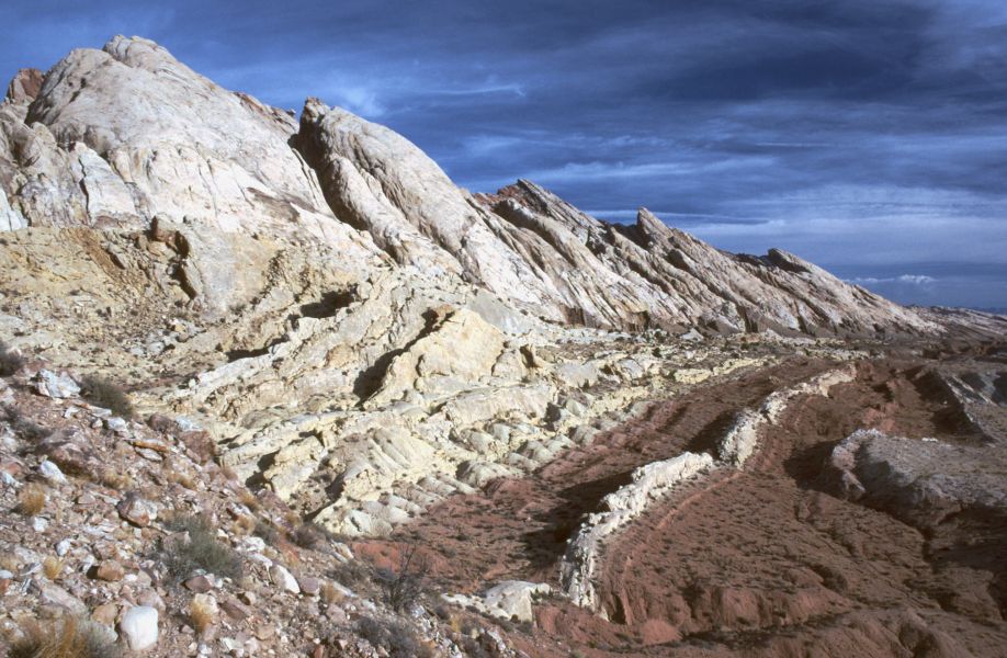
Navajo Sandstone frequently overlies and interfingers with the Kayenta Formation of the Glen Canyon Group. Together, these formations can result in immense vertical cliffs of up to 2,200 feet (670 m). Atop the cliffs, Navajo Sandstone often appears as massive rounded domes and bluffs that are generally white in color.

Appearance and provenance

[edit]
The Great White Throne in Zion National Park is an example of white Navajo Sandstone
Stevens Arch, near the mouth of Coyote Gulch in the Canyons of the Escalante, is formed from a layer of Navajo Sandstone. The opening is 220 feet (67 m) wide and 160 feet (49 m) high.

Navajo Sandstone frequently occurs as spectacular cliffs, cuestas, domes, and bluffs rising from the desert floor. It can be distinguished from adjacent Jurassic sandstones by its white to light pink color, meter-scale cross-bedding, and distinctive rounded weathering.

The wide range of colors exhibited by the Navajo Sandstone reflect a long history of alteration by groundwater and other subsurface fluids over the last 190 million years. The different colors, except for white, are caused by the presence of varying mixtures and amounts of hematite, goethite, and limonite filling the pore space within the quartz sand comprising the Navajo Sandstone. The iron in these strata originally arrived via the erosion of iron-bearing silicate minerals.

Initially, this iron accumulated as iron-oxide coatings, which formed slowly after the sand had been deposited. Later, after having been deeply buried, reducing fluids composed of water and hydrocarbons flowed through the thick red sand which once comprised the Navajo Sandstone. The dissolution of the iron coatings by the reducing fluids bleached large volumes of the Navajo Sandstone a brilliant white. Reducing fluids transported the iron in solution until they mixed with oxidizing groundwater. Where the oxidizing and reducing fluids mixed, the iron precipitated within the Navajo Sandstone.

Depending on local variations within the permeability, porosity, fracturing, and other inherent rock properties of the sandstone, varying mixtures of hematite, goethite, and limonite precipitated within spaces between quartz grains. Variations in the type and proportions of precipitated iron oxides resulted in the different black, brown, crimson, vermillion, orange, salmon, peach, pink, gold, and yellow colors of the Navajo Sandstone.

The precipitation of iron oxides also formed laminae, corrugated layers, columns, and pipes of ironstone within the Navajo Sandstone. Being harder and more resistant to erosion than the surrounding sandstone, the ironstone weathered out as ledges, walls, fins, "flags", towers, and other minor features, which stick out and above the local landscape in unusual shapes.[5][6]

Age and history of investigation

[edit]

The age of the Navajo Sandstone is somewhat controversial. It may originate from the Late Triassic but is at least as young as the Early Jurassic stages Pliensbachian and Toarcian.[2] There is no type locality of the name. It was simply named for the 'Navajo Country' of the southwestern United States.[7] The two major subunits of the Navajo are the Lamb Point Tongue (Kanab area) and the Shurtz Sandstone Tongue (Cedar City area).[8]

The Navajo Sandstone was originally named as the uppermost formation of the La Plata Group by Gregory and Stone in 1917.[7] Baker reassigned it as the upper formation of Glen Canyon Group in 1936.[9] Its age was modified by Lewis and others in 1961.[10] The name was originally not used in northwest Colorado and northeast Utah, where the name 'Glen Canyon Sandstone' was preferred.[11]

A 2019 radioisotopic analysis suggests that the Navajo Sandstone formation dates to the early Jurassic and began around 200-195 million years ago.[12] Kevin Padian stated in 1989 that the Navajo Sandstone extended into the Toarcian Stage.[13]

Depositional environment

[edit]

The sandstone was deposited in an arid erg on the Western portion of the Supercontinent Pangaea. This region was affected by annual monsoons that came about each winter when cooler winds and wind reversal occurred.

Outcrop localities

[edit]
The Golden Throne, a rock formation in Capitol Reef National Park. Though the park is famous for white domes of the Navajo Sandstone, this dome's color is a result of a lingering section of yellow Carmel Formation carbonate, which has stained the underlying rock.

Navajo Sandstone outcrops are found in these geologic locations:

The formation is also found in these parklands (incomplete list):

Vertebrate paleofauna

[edit]

Ornithodires

[edit]

Indeterminate theropod remains geographically located in Arizona, USA.[14] Theropod tracks are geographically located in Arizona, Colorado, and Utah, USA.[14] Ornithischian tracks located in Arizona, USA.[14]

Color key
Taxon Reclassified taxon Taxon falsely reported as present Dubious taxon or junior synonym Ichnotaxon Ootaxon Morphotaxon
Notes
Uncertain or tentative taxa are in small text; crossed out taxa are discredited.
Ornithodires of the Navajo Sandstone
Genus Species Location Stratigraphic position Material Notes Images

Ammosaurus[14]

Ammosaurus cf. major[14]

Ammosaurus
Segisaurus
Seitaad

Dilophosaurus[15]

D. wetherilli[15]

Attributed trackways at Red Fleet State Park.[15]

Pteraichnus[16]

Segisaurus[14]

S. halli[14]

"Partial postcranial skeleton."

Seitaad[17]

S. ruessi[17]

Iron oxide concretions

[edit]

Interior of a Moqui Marble
Moqui Marbles, hematite concretions, from the Navajo Sandstone of southeast Utah. Scale cube, with "W", is one centimeter square.
Moqui Marbles in place in the Navajo Sandstone, Snow Canyon State Park, SW Utah.

The Navajo Sandstone is also well known among rockhounds for its hundreds of thousands of iron oxide concretions. Informally, they are called "Moqui Marbles" and are believed to represent an extension of Hopi Native American traditions regarding ancestor worship ("moqui" translates to "the dead" in the Hopi language). Thousands of these concretions weather out of outcrops of the Navajo Sandstone within south-central and southeastern Utah within an area extending from Zion National Park eastward to Arches and Canyonland national parks. They are quite abundant within Grand Staircase–Escalante National Monument.[5][6]

The iron oxide concretions found in the Navajo Sandstone exhibit a wide variety of sizes and shapes. Their shape ranges from spheres to discs; buttons; spiked balls; cylindrical hollow pipe-like forms; and other odd shapes. Although many of these concretions are fused together like soap bubbles, many more also occur as isolated concretions, which range in diameter from the size of peas to baseballs. The surface of these spherical concretions can range from being very rough to quite smooth. Some of the concretions are grooved spheres with ridges around their circumference.[5][6]

The abundant concretions found in the Navajo Sandstone consist of sandstone cemented together by hematite (Fe2O3), and goethite (FeOOH). The iron forming these concretions came from the breakdown of iron-bearing silicate minerals by weathering to form iron oxide coatings on other grains. During later diagenesis of the Navajo Sandstone while deeply buried, reducing fluids, likely hydrocarbons, dissolved these coatings. When the reducing fluids containing dissolved iron mixed with oxidizing groundwater, they and the dissolved iron were oxidized. This caused the iron to precipitate out as hematite and goethite to form the innumerable concretions found in the Navajo Sandstone. Evidence suggests that microbial metabolism may have contributed to the formation of some of these concretions.[18] These concretions are regarded as terrestrial analogues of the hematite spherules, called alternately Martian "blueberries" or more technically Martian spherules, which the Opportunity rover found at Meridiani Planum on Mars.[5][6]

See also

[edit]

References

[edit]

Further reading

[edit]
Revisions and contributorsEdit on WikipediaRead on Wikipedia
from Grokipedia
The Navajo Sandstone is an Early Jurassic geological formation renowned for its vast eolian deposits of cross-bedded sandstone, formed from windblown sand dunes in one of the largest ancient deserts known to have existed on Earth. Deposited during a period of drying climate across the supercontinent Pangaea, when the region now encompassing the Colorado Plateau was located near the equator, the formation preserves evidence of massive ergs (sand seas) migrated by prevailing trade winds. Radiometric dating of carbonate deposits within the sandstone indicates deposition began in the Hettangian stage of the Early Jurassic, around 200.5 ± 1.5 million years ago, with parts extending into the Sinemurian stage at approximately 195 million years ago, marking the onset of Jurassic sedimentation following the Triassic. The sandstone's grains, primarily quartz, originated from ancient Proterozoic sources dating between 1.2 billion and 950 million years old, as determined by uranium-lead and helium dating techniques. In terms of scale, the Navajo Sandstone reaches thicknesses of up to 2,500 feet (750 meters) and originally covered about 150,000 square miles (390,000 km²) across present-day , , , , and , named for the Navajo Nation's traditional lands. It forms the uppermost unit of the Glen Canyon Group, conformably overlying the Kayenta Formation and underlying the Carmel Formation, with its base exhibiting time-transgressive characteristics over several million years. Notable for its cross-bedding—diagonal layering that reveals ancient wind directions, typically dipping in the direction of dune migration—the formation displays a spectrum of colors from vibrant reds (due to hematite coatings) to bleached whites and intermediate shades of yellow, orange, and pink, resulting from alteration over time. It also hosts abundant concretions, ranging from small spheres to large columnar structures, which formed through the re-precipitation of dissolved iron in bleached zones and represent some of the world's most prominent examples. The Navajo Sandstone's dramatic exposures create iconic landscapes in numerous U.S. national parks and monuments, including Zion, Arches, Canyonlands, Capitol Reef, and Glen Canyon, where it forms towering cliffs, arches, and slickrock surfaces that highlight the region's geological history and support diverse ecosystems. Its preservation of ancient desert dynamics provides critical insights into paleoclimate, sediment transport, and the breakup of Pangaea, while historically serving Indigenous peoples, such as the Navajo, for pigments and tools derived from its iron-rich materials.

Introduction

Physical Description

The Navajo Sandstone displays a of colors, ranging from white and pale pink to salmon and occasional red bands, creating visually striking contrasts in outcrops across the . In , the formation is particularly noted for its prominent white domes and sheer cliffs that dominate the landscape. One of its most distinctive features is the large-scale , with sets reaching up to 30 meters in height, revealing the internal layering of ancient sand deposits through diagonal planes that slope at angles often exceeding 25 degrees. These patterns are prominently exposed in cliff faces and contribute to the formation's sculptural quality. The formation attains a maximum thickness of approximately 700 meters in regions like southwestern , where it manifests as towering cliffs, rounded buttes, and isolated domes that weather into dramatic profiles. Exposed surfaces of the Navajo Sandstone often exhibit smooth, wind-eroded textures, including polished slickrock expanses and ventifacts—rocks sculpted by abrasion into faceted shapes—in arid settings. These features are vividly showcased in iconic sites such as The Wave in , where swirling patterns emerge from differential erosion.

Geological Significance

The Navajo Sandstone represents the largest known ancient erg, or sand sea, on Earth, with estimates of its depositional extent ranging from 625,000 km² to over 2,000,000 km²; some assessments suggest it was larger than the combined dune fields (ergs) of the modern , which cover about 1,280,000–1,710,000 km². This vast scale provides an unparalleled paleoenvironmental archive, preserving records of eolian processes, dune migration, and over millions of years during the , offering insights into ancient desert dynamics unmatched by other formations. As a key record of climate, the Navajo Sandstone documents arid conditions across the western margin of the supercontinent , positioned about 10–20° north of the around 190 million years ago. Its cross-bedded structures reveal north-northwesterly wind patterns and variable hydroclimates, with eolian sands interspersed by episodic wetter interdune settings during Pangaea's early breakup, highlighting shifts in and precipitation that influenced global paleogeography. In regional geology, the Navajo Sandstone forms the uppermost unit of the Glen Canyon Group, conformably overlying the Kayenta Formation and serving as a foundational layer for subsequent strata like the Carmel Formation. This stratigraphic position underscores its role in the Colorado Plateau's tectonic and sedimentary evolution, where it intertongues with underlying fluvial and lacustrine deposits, stabilizing the basin architecture developed amid uplift. Beyond its scientific value, the Navajo Sandstone holds significant cultural and recreational importance, shaping iconic landscapes in national parks such as and Arches, where its towering cliffs and slickrock formations exceed 2,000 feet in thickness and attract millions for , , and . These exposures, including Zion's Temples and Towers of the Virgin, inspire artistic representations and embody the Southwest's geological heritage, enhancing public appreciation of .

Geological Framework

Age and Stratigraphy

The is dated to the , specifically spanning the and stages, with deposition occurring between approximately 201 and 190 million years ago (Ma). This temporal range was established through uranium-lead (U-Pb) of carbonate deposits within the formation in southeastern , yielding precise ages of 200.5 ± 1.5 Ma at the base and 195.0 ± 7.7 Ma higher in the section, confirming an onset in the earliest rather than the previously assumed later stages. These dates indicate a depositional duration of roughly 10-15 million years, during which vast eolian dunes accumulated across the region. Stratigraphically, the Navajo Sandstone forms the uppermost unit of the Group and exhibits significant thickness variations, ranging from 200 to 670 meters (650 to 2,200 feet) across its extent, with thicker accumulations in central and southern exposures. It conformably overlies the Late Triassic to Early Jurassic Wingate Sandstone in western areas or the Kayenta Formation in eastern regions, marking a transition from fluvial to dominantly eolian environments. The formation is overlain by units, including the Page Sandstone to the north or the Temple Cap Formation (basal Carmel Formation) to the south, with an erosional often present at the top due to later tectonic uplift. Globally, the Navajo Sandstone correlates to the Lower series, representing one of the earliest major eolian erg systems and comparable in scale to contemporaneous desert deposits like the Cape Supergroup sandstones in or the Botucatu Formation in , all formed under similar arid, rift-related climatic conditions during the breakup of . Recent refinements to the stratigraphic framework include a 2025 paleomagnetic study of concretions within the Navajo Sandstone, which extends the record of geomagnetic variations and associated environmental shifts, providing higher-resolution constraints on depositional timing and post-depositional alterations over the formation's full vertical extent.

History of Research

The Navajo Sandstone was formally named in 1917 by Herbert E. Gregory and Raymond C. Stone as the uppermost formation of the Group during early 20th-century U.S. Geological Survey (USGS) reconnaissance mapping of the region in , , and . These initial surveys, part of broader efforts to document the of the , highlighted the formation's distinctive cross-bedded sandstones and their exposure in remote areas, laying the groundwork for subsequent geological explorations. By the 1930s, detailed mapping by USGS teams, including Herbert Gregory's comprehensive study of the Navajo country, expanded understanding of its regional extent and structural relationships. Early age assignments placed the Navajo Sandstone within the to interval, often grouped with underlying units like the Wingate Sandstone, due to limited evidence and stratigraphic correlations. By , however, paleontological and lithostratigraphic analyses shifted interpretations toward an exclusively age, with refinements in the by Harrell L. James and others confirming its placement based on regional correlations. This consensus was bolstered in 2019 by U-Pb radioisotopic dating of carbonate cements, which yielded ages of approximately 200.5 ± 1.5 Ma, establishing the formation's onset in the stage of the and necessitating reevaluation of its chronostratigraphy. The eolian depositional origin of the Navajo Sandstone was recognized as early as 1917 through observations of its large-scale, tangential cross-bedding and fine-grained quartz composition, which Gregory and Stone interpreted as evidence of wind-dominated arid conditions. Subsequent studies in the 1920s and 1930s, including Gregory's 1938 synthesis, reinforced this view by comparing the cross-sets to modern desert dunes. Refinements in the 1980s and 2000s advanced sedimentological models, with Doe and Dott (1980) analyzing deformed cross-bedding to distinguish eolian from aqueous processes, and Blakey et al. (1988) integrating paleowind directions and erg-margin dynamics to map the formation as part of a vast Early Jurassic sand sea. Recent investigations have focused on interdisciplinary approaches to unresolved aspects of the formation's history. In 2022, iron isotope analyses of concretions revealed negative δ⁵⁶Fe values indicative of siderite precursors formed under reducing conditions, providing insights into early diagenetic fluid pathways. A 2025 paleoecological study identified six biofacies integrating trace fossils, microbial structures, and lithofacies, challenging traditional eolian ichnofacies models by evidencing more diverse fluvial and lacustrine influences within the erg system. As of 2025, significant research gaps persist in microbial diagenesis, particularly the role of ancient biofilms in iron oxide precipitation and porosity evolution, with calls for integrated geomicrobiological analyses to address these uncertainties.

Formation and Environment

Depositional Setting

The Navajo Sandstone formed along the western margin of the supercontinent during the , between approximately 200 and 195 million years ago, at a paleolatitude of about 20° to 30° north. This position placed the depositional area within a subtropical arid belt, where and the system influenced regional climate patterns. The megamonsoon, driven by seasonal shifts in , introduced episodic moisture to an otherwise hyper-arid environment, promoting the accumulation of vast eolian deposits without direct marine incursions. The primary was an expansive erg, or inland sand sea, spanning roughly 1,000 km across and covering up to 625,000 km² in its original extent. Dune fields within this erg migrated under prevailing north-northwesterly winds, forming large-scale cross-bedded structures that record the dominance of . Climatic conditions were predominantly dry, with low supporting dune preservation, but interrupted by phases that lasted decades to centuries, as evidenced by interdune playa deposits containing microbial mats, evaporites, and paleosols. Regionally, the setting was a cratonic interior with minimal tectonic activity, characterized by broad in intracratonic basins that accommodated thick accumulation up to 750 m. Minor faulting occurred along basin margins, but the absence of significant deformation or marine sediments underscores the continental nature of deposition, insulated from contemporaneous rifting along Pangea's eastern edges.

Sediment Sources and Processes

The sediment comprising the Navajo Sandstone primarily originated from the erosion of the Appalachian orogen during the late , with detrital grains providing age signatures that match those from Appalachian basement rocks. These sands were recycled through multiple sedimentary cycles, resulting in a mature composition dominated by (approximately 90-95%) with minor and accessory minerals like and . Traces of Ouachita orogenic material may also contribute, reflecting broader eastern North American sources, though Appalachian input predominates based on studies. Initial long-distance transport occurred via ancient fluvial systems that carried the sediment westward across the North American craton during the Early Jurassic, analogous to modern transcontinental rivers like the Amazon. Upon reaching the western interior, winds from the north-northwest redistributed the sands eolianly over vast distances, forming the expansive Navajo erg that covered approximately 625,000 km². High-energy winds capable of sand entrainment facilitated dune construction, as inferred from grain size, sorting, and cross-stratification patterns typical of high-energy eolian environments. The internal architecture of the Navajo Sandstone records migration of transverse and barchanoid dunes, preserved as large-scale sets with foreset dip angles of 20-35°, which indicate prevailing unimodal winds from the north to northwest. These dunes, often exceeding 20 m in height, advanced through avalanching on slip faces and ripple migration on stoss slopes, with bounding surfaces marking episodes of dune stabilization or reactivation. Minor fluvial influences are evident in the basal units, where paleosols and channel-fill sandstones comprise about 5-10% of the total volume, reflecting intermittent wet phases with stream incision and amid the dominant eolian regime.

Characteristics and Composition

Lithology and Structure

The Navajo Sandstone is primarily composed of medium- to coarse-grained quartz arenite, characterized by well-sorted and rounded quartz grains that reflect extensive eolian transport and abrasion. This lithology dominates the formation, with grain sizes typically ranging from 0.25 to 0.5 mm, though coarser fractions up to 1 mm occur locally in high-energy dune facies. The rock's homogeneity arises from its derivation almost exclusively from quartz, with minor feldspathic components in some variants, resulting in a durable, cliff-forming sandstone. Bedding in the Navajo Sandstone is dominated by large-scale trough , indicative of migrating transverse and barchanoid s in an ancient erg environment. Cross-bed sets reach thicknesses of up to 30 m, with foreset beds dipping at 20–35 degrees and displaying tangential bases that scour into underlying layers. Reactivation surfaces—subhorizontal planes within these sets—mark episodic pauses in dune migration, often separating sequences of grainfall and wind-ripple laminae from overlying coarser grainflow deposits. Structural variations include slumping and soft-sediment deformation structures concentrated in interdune areas, where wetter conditions facilitated ductile flow and shear failure along bedding planes. These features, such as contorted laminae and recumbent folds, contrast with the more rigid cross-bedded dune cores. Studies have identified architectural evidence of large-scale slumps triggered by oversteepening and liquefaction in the Navajo Sandstone at Zion National Park. The formation exhibits high initial porosity of approximately 30%, attributable to its well-sorted granular fabric, though subsequent cementation has reduced this to 13–25% in many outcrops. Permeability values commonly range from 100 to 880 millidarcies, influenced by the interconnected pore network preserved from eolian deposition. These properties render the Navajo Sandstone a significant reservoir in subsurface settings, such as the Covenant Field in central .

Mineralogy and Diagenesis

The Navajo Sandstone is predominantly composed of , comprising over 95% of its mineral content, making it a classic quartz arenite. Accessory minerals include as grain-coating and pore-filling clays, as a primary , and trace heavy minerals such as , which are utilized for detrital zircon to trace sediment . Diagenesis of the Navajo Sandstone involved multiple phases spanning over 100 million years of burial, from the deposition around 190 Ma to exhumation in the . Early diagenetic processes included silica cementation through overgrowths on detrital grains and localized precipitation, particularly as ferroan calcite in some horizons, which partially occluded primary while preserving intergranular spaces. Subsequent phases featured precipitation, where initial red coatings formed from the oxidation of detrital iron minerals shortly after deposition, imparting the characteristic reddish hues to much of the formation. Color variations in the Navajo Sandstone arise from diagenetic alteration of iron: the prevalent tones result from the oxidation of ferrous iron (Fe²⁺) to ferric iron (Fe³⁺) as (Fe₂O₃), while bleached white zones formed later during deeper burial when reducing fluids, likely migrating hydrocarbons, dissolved these iron oxide coatings and mobilized iron for reprecipitation elsewhere. evolution during these prolonged diagenetic events involved progressive occlusion by cements and clays, reducing initial eolian from around 30% to 10-15% in many subsurface equivalents, though exposures retain higher secondary due to later dissolution. Recent studies have provided insights into these processes, including 2022 iron isotope analyses revealing that many iron oxide features originated from siderite (FeCO₃) precursors with negative δ⁵⁶Fe values, indicating microbial iron reduction during early diagenesis. Additionally, evidence from banded iron oxide structures points to microbial biofilms facilitating initial cementation at redox interfaces, influencing the precipitation of iron minerals and contributing to the formation's heterogeneous coloration and permeability.

Distribution

Extent and Thickness

The Navajo Sandstone is exposed across more than 350,000 km² in the , primarily within the region spanning southern , , northwestern , southern , and northern , where it pinches out eastward. Thickness of the formation varies regionally from near 0 m at its margins to over 750 m (2,500 ft), with the maximum development in southwestern reaching up to 750 m and approximately 400 m in south-central ; it generally thins northward and westward, averaging about 380 m in and attaining up to 550 m in parts of . The original depositional volume of the Navajo erg is estimated at 60,000–140,000 km³. The depositional basin exhibited an elongate north-south over 1,000 km in length, aligned with prevailing wind patterns from the northwest that drove eolian sediment transport; present-day exposures represent erosional remnants shaped by uplift and incision of the .

Key Outcrop Areas

The Navajo Sandstone is prominently exposed in several primary localities across the , where its thick sequences of cross-bedded eolian deposits form dramatic landscapes. In , , the formation creates towering vertical cliffs that rise over 700 meters, providing exceptional vertical exposures of its cross-stratification and serving as a key site for studying ancient dune architecture. In , , the sandstone underlies iconic natural arches such as , where differential along joints exposes large-scale cross-beds and highlights the unit's resistance to in dome-like structures. In , , it forms expansive slickrock areas and canyon rims that reveal cross-bedded layers and contribute to the park's rugged terrain. Further south, in within , , the formation manifests as undulating, wave-like sandstone layers known as The Wave, offering horizontal exposures that reveal intricate dune foreset bedding and diagenetic features. Exposures in , and , include broad cliff faces and submerged sections in that display the formation's color variations and structural features. Secondary exposures occur in additional protected areas, providing complementary views of the formation's lateral continuity and variations. Grand Staircase-Escalante National Monument in southern features broad outcrops of the Navajo Sandstone, including the characteristic White Cliffs, which display its full stratigraphic sequence in a relatively undisturbed setting. In , , the sandstone forms rugged escarpments and canyon walls that expose its upper and middle members, aiding in regional correlations. Limited outcrops extend into southwestern near the region and southeastern , where thinner remnants are visible in fault-bounded blocks but lack the extensive accessibility of and sites. These key outcrop areas are predominantly on federal lands managed by the and , ensuring their preservation through strict conservation measures. Access to sensitive sites like requires permits via a system to limit visitor impact and prevent accelerated from foot traffic. In national parks such as and Arches, trails and viewpoints are designated to protect the fragile sandstone surfaces while allowing public observation. Exposures vary significantly by location, with the best cross-sections visible in incised canyons like those in , where stream erosion cuts through the full thickness to reveal vertical stacking of dune sets. In more arid settings like Arches and , wind-driven progressively uncovers patterns, emphasizing the formation's granular texture and color banding without deep incision.

Paleontological Content

Body Fossils

Body fossils in the Navajo Sandstone are exceptionally rare due to the predominantly eolian , where wind and migration typically destroyed skeletal remains before they could be preserved. Most vertebrate body fossils occur in interdune or playa deposits, which represent localized wet phases within the otherwise arid erg system, allowing for better burial and mineralization of remains. These settings contrast with the vast cross-bedded sandstones, where no major quarries or articulated skeletons have been documented, highlighting the taphonomic bias toward fragmentary or isolated elements in protected interdunal areas. The known vertebrate body fossils primarily include isolated bones and partial skeletons of early theropod dinosaurs, basal sauropodomorphs, crocodylomorphs, and non-mammalian synapsids (therapsids). Theropod remains are represented by , a small coelophysoid known from a single partial discovered in calcareous sandstone near Segi Canyon, , featuring a lightweight build adapted for agility in dune environments. Basal sauropodomorphs are exemplified by Seitaad ruessi, a juvenile specimen from the formation's base in southeastern , comprising an articulated torso and limbs that suggest semi-bipedal locomotion suitable for navigating interdune terrains. Crocodylomorph fossils include protosuchid remains, such as isolated osteoderms and vertebrae from north-central interdunes, indicating small, terrestrial or semi-aquatic forms that inhabited wetter microhabitats. Therapsids are documented by tritylodontid specimens, including a partial postcranial from interdune deposits in , reflecting herbivorous or omnivorous mammals-like reptiles that burrowed for protection in the harsh desert. Key discoveries from the late underscore the intermittent wet conditions that facilitated preservation. In the early , excavations in Arizona's interdune layers yielded the tritylodontid skeleton, providing the evidence of synapsid habitation in the Navajo erg and suggesting adaptation to playa lakes for foraging. Earlier finds, such as the 1930s , highlighted the presence of agile predators, though initial descriptions underestimated its theropod affinities until redescribed in 2005. These isolated recoveries, rather than mass assemblages, emphasize the scarcity of body s compared to elsewhere in the formation. Recent paleontological work has expanded the known diversity and contextualized these fossils within broader reconstructions. In 2023, low water levels in exposed the first tritylodontid bonebed in the Navajo Sandstone, yielding hundreds of pounds of bones and teeth from multiple individuals in an interdune deposit, offering insights into gregarious behavior among these synapsids. Additionally, a 2017 report documented the first actinopterygian fish scales from southern interdunes, indicating episodic aquatic refugia. By 2025, integrated paleoecological analyses have combined these body fossils with to model a wet-desert , where interdune oases supported diverse vertebrates during periodic moisture influxes.

Trace Fossils

The Navajo Sandstone, formed in an , preserves a rich record of trace fossils that far outnumber body fossils, reflecting preservation biases in dune and interdune settings where tracks and burrows were readily imprinted on damp surfaces but skeletal remains rarely accumulated. This dominance of ichnofossils provides key insights into vertebrate and invertebrate behaviors in a vast . The dominant ichnofauna includes theropod dinosaur tracks such as (small, three-toed prints indicating agile bipeds) and (larger, robust theropod impressions), alongside ornithischian tracks like those resembling Anomoepus (quadrupedal or bipedal prints with claw marks). Arthropod burrows, often meniscate or branched, occur abundantly in damp interdune areas, suggesting sheltering or feeding activities by insects and other invertebrates during periodic wetting events. Trackway assemblages, such as those assigned to Dilophosauripus (attributed to theropods like ), are common across multiple sites and feature parallel or converging paths that imply social grouping, herding, or migratory behavior among these predators. The assemblages define an eolian-specific ichnofacies characterized by arthropod-dominated burrows in dunes and tracks in interdunes, but recent 2025 analyses question its uniqueness, proposing mixed fluvial influences from ephemeral streams that enhanced preservation and diversity. Major sites include , where hundreds of tracks from theropods and ornithischians occur in Navajo outcrops, and Coral Pink Sand Dunes State Park, preserving thousands of theropod prints on dune surfaces; these assemblages aid paleodirection analysis by revealing animal movement orientations relative to ancient wind patterns.

Special Features

Iron Oxide Concretions

Iron oxide concretions, commonly known as Moqui Marbles, are distinctive spherical nodules embedded within or eroded from the Navajo Sandstone. These concretions exhibit a characteristic rind-core structure, featuring a hard outer shell of iron oxides surrounding a softer, iron-poor sandstone nucleus composed primarily of quartz grains. They typically range in diameter from 0.5 to 10 centimeters, though most are pea- to golf ball-sized, and can occur in varied morphologies such as buttons, discs, or irregular clusters. Moqui Marbles are particularly abundant in southern Utah outcrops of the Navajo Sandstone, including areas within Grand Staircase-Escalante National Monument and near Zion National Park, where they accumulate in dense "puddles" on the surface after erosion exposes them. The composition of these concretions consists of an outer rind dominated by (Fe₂O₃) and (FeOOH), which cement the surrounding , while the core remains largely uncemented and low in iron content. This structure formed through approximately 20 to 30 million years ago, during the to epochs, when mineral-rich fluids percolated through the porous Navajo Sandstone, mobilizing and redepositing iron. The process involved the oxidation of dissolved iron ions, which precipitated as concentric layers around sites, creating the durable rinds that resist better than the host rock. Recent research has elucidated the detailed formation mechanism, highlighting the role of percolating fluids in oxidizing iron derived from the . A study using (δ⁵⁶Fe) revealed negative values as low as -0.74‰ in the concretions, providing evidence for (FeCO₃) precursors that formed under reducing conditions before subsequent oxidation to and in a . Complementing this, a 2025 paleomagnetic investigation demonstrated that the within these concretions records geomagnetic field reversals over millions of years, with multiple magnetic components indicating a prolonged, multi-stage process spanning thousands to potentially 100 million years at ambient temperatures. These findings underscore a sequential transformation: initial rapid deposition of iron hydroxides followed by slow conversion to stable oxides, capturing environmental changes in the chemistry. Moqui Marbles hold significant cultural and scientific value. Among Native American communities, particularly the Hopi, they are revered as "shaman stones" or embodiments of ancestral spirits, used in rituals for protection, healing, and meditation, with legends describing them as marbles played with by departed souls. Scientifically, they serve as terrestrial analogs to the hematite "blueberries" observed on Mars by NASA's Opportunity rover, offering insights into ancient aqueous environments and potential biosignatures on other planets due to their formation in water-saturated conditions. Hypotheses of microbial mediation further enhance their interest, suggesting that iron-reducing bacteria may have facilitated the conversion of siderite to oxides, as indicated by microscopic tubular structures and metabolic byproducts preserved within the concretions.

Landforms and Erosion Patterns

The Navajo Sandstone has been sculpted by differential weathering and into iconic landforms, including natural arches, balanced rocks, and slot canyons, primarily through the exploitation of pre-existing joints and variations in rock cementation. Natural arches, such as in , form when parallel joint sets in the sandstone are widened by subaerial , creating thin fins that are further eroded at their bases by freeze-thaw cycles and water infiltration, eventually spanning openings up to 300 feet wide. Balanced rocks emerge from uneven where more resistant caps or pediments protect underlying pedestals, as seen in formations where differential weathering removes softer sandstone layers beneath harder ones, leaving precariously perched boulders. Slot canyons, like those in , result from concentrated fluvial downcutting along closely spaced vertical joints, where propagates narrow, incised channels through the massive sandstone, amplified by flash floods that exploit these weaknesses. Weathering mechanisms in the Navajo Sandstone are dominated by physical processes that target structural discontinuities. Freeze-thaw cycles, occurring up to 46 times per winter in shaded areas, cause in joints and sheeting fractures to expand, prying apart slabs and accelerating granular disintegration along scarps. Wind abrasion, driven by southwesterly gusts carrying grains, creates a loop where liberated particles further scour the rock, forming stepped topography, flute-like scours, and overhanging pits tens of meters across, particularly in friable grainflow layers. concretions, more resistant to , contribute to localized rind formation and protect adjacent areas, enhancing differential patterns that outline landforms. Sheeting joints, parallel to the surface and formed under , segment the into polygonal slabs (averaging 3.5 meters in diameter), which buckle and erode into gullies, further shaping buttes and towers. The geomorphic evolution of Navajo Sandstone landforms began with exposure following the , which uplifted the between 70 and 40 million years ago, stripping overlying sediments and initiating widespread subaerial erosion. Since then, ongoing backwasting of rock sheets—where scarps retreat upslope via weathering—has lowered the plateau at rates of approximately 0.16 mm per year, based on denudation estimates of 1,600 meters over the past 10 million years, forming ridges, valleys, and isolated domes. This slow retreat preserves massive exposures while allowing dynamic sculpting, with arches and canyons continuing to evolve through episodic collapses, such as the 2008 failure of Wall Arch. Human activities have intensified erosion patterns in protected areas like Arches and National Parks, where Navajo Sandstone dominates the landscape. Off-trail hiking and trail use compact biological soil crusts, which stabilize surfaces and reduce water infiltration; this damage increases runoff and wind erosion, with recovery times spanning 5–50 years depending on crust type. introduces abrasion and stress to fractures, accelerating the breakdown of fins and arches, while vehicle tracks create erosional channels that funnel water into sensitive formations. Conservation efforts by the include monitoring erosion rates at key sites like , restricting access to fragile areas, and promoting low-impact practices to mitigate these impacts and preserve the sandstone's integrity.

References

Add your contribution
Related Hubs
User Avatar
No comments yet.