Hubbry Logo
Lubec, MaineLubec, MaineMain
Open search
Lubec, Maine
Community hub
Lubec, Maine
logo
8 pages, 0 posts
0 subscribers
Be the first to start a discussion here.
Lubec, Maine
Lubec, Maine
from Wikipedia

Lubec (/lˈbɛk/ loo-BEK) is a town in Washington County, Maine, United States. It is the easternmost municipality in the contiguous U.S. (see extreme points of the United States) and is the country's closest continental location to Africa.[2]

Key Information

The town, with a population of 1,237 at the 2020 census,[3] is home to Quoddy Head State Park.

History

[edit]

Located on a peninsula overlooking an ice-free harbor, the town was first settled about 1775. Originally part of Eastport, it was set off and incorporated on June 21, 1811, and named for Lübeck, Germany.[4] Following the War of 1812, Lubec was the site of considerable smuggling trade in gypsum, although principal industries remained agriculture and fisheries. By 1859, there was a tannery, three gristmills and nine sawmills; by 1886, there were also two shipyards, three boatbuilders and three sailmakers.[5]

From 1897 to 1898, the town was the site of a swindle in the sale of stock in the Electrolytic Marine Salts Company, the brainchild of Reverend Prescott Jernegan and Charles Fisher of Martha's Vineyard.[6] Jernegan claimed to have developed a method of using "accumulators" to get gold from sea water, and bought an old grist mill to turn it into a factory. The scheme attracted an abundance of investors, who were all too eager to funnel money into the company after being promised astronomical returns. In the summer of 1898, work was suspended without explanation. Jernegan and Smith vanished, and the fraud was gleefully exposed by newspapers across New England.[6]

Lubec reached its population peak in the 1910s and 1920s, hovering a little above 3,300. Since then, the population has generally been in a gradual but steady decline.[citation needed]

Before the year 2000 some area factory jobs disappeared. Meanwhile, Lubec's popularity increased with media outlets promoting it as a place to possibly see the start of the year 2000. Artists, persons with no children, and persons who were in older demographics moved to the community while families with children moved out. Real estate prices also rose. By 2010 many residents worked online.[7]

As of 2020, its population had fallen to 1,237.

Geography

[edit]

Lubec is located in northeastern Maine, at 44°51′38″N 66°59′5″W / 44.86056°N 66.98472°W / 44.86056; -66.98472.[8]

According to the United States Census Bureau, the town has a total area of 78.38 square miles (203.00 km2), of which 33.25 square miles (86.12 km2) is land and 45.13 square miles (116.89 km2) is water.[9] Lubec is located on a peninsula in Passamaquoddy Bay, slightly south of Eastport. The West Quoddy Head is southeast.

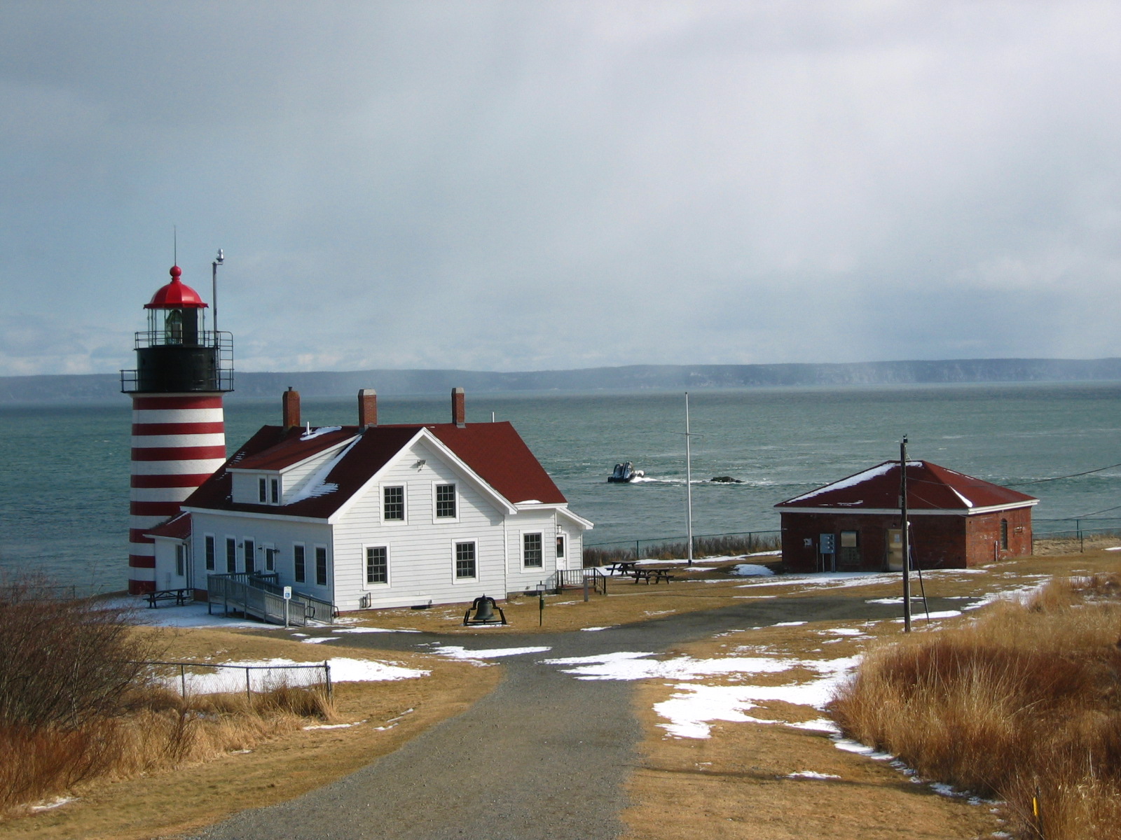
Lubec is the easternmost town of the contiguous United States.[10] West Quoddy Head in Lubec is the easternmost point in the contiguous United States, located at 44°48′54″N 66°57′1″W / 44.81500°N 66.95028°W / 44.81500; -66.95028 longitude. It is adjacent to the Quoddy Narrows, a narrow strait between Canada and the United States, one of the entrances into Passamaquoddy Bay. Since 1808, West Quoddy Head Lighthouse has been on the site to guide ships through this waterway. The present lighthouse with its distinctive red-and-white stripes was built in 1858.

Lubec is crossed by Maine State Route 189. The Franklin Delano Roosevelt Bridge connects the town to Campobello Island, New Brunswick, Canada.

Sites of interest

[edit]

Bay of Fundy International Marathon

[edit]

The Bay of Fundy International Marathon is a marathon between Lubec and Campobello Island, New Brunswick, Canada. A 10K is also organized alongside the marathon. The 10K takes place entirely within Lubec.[11]

The race begins at West Quoddy Head Lighthouse, which is the easternmost point in the United States. Runners cross the Franklin Delano Roosevelt Bridge connecting Maine to New Brunswick and run until they reach Head Harbour Lighthouse (East Quoddy Lighthouse), at which time the runners turn around and return to Lubec.[11]

The first marathon was run in 2013. It included over 500 registered runners and was held in June. The race provided significant economic benefits to the area. The 2014 edition featured fewer runners (286 total). The organizers attributed the decrease to the "Boston effect", whereby marathon runners chose other marathons to run in order to qualify for the 2014 Boston Marathon.[11]

Climate

[edit]

Lubec has a humid continental climate with mild summers and cold winters. Generally speaking, it is relatively cold for its coastline position at 44 degrees latitude, but milder in winter than nearby Machias due to moderate warming by the adjacent waters of the Atlantic. The climate is similar to that of nearby Eastport. The Weather Channel provides interpolated climate data based on nearby areas.

Climate data for Lubec, Maine
Month Jan Feb Mar Apr May Jun Jul Aug Sep Oct Nov Dec Year
Record high °F (°C) 61
(16)
65
(18)
79
(26)
84
(29)
93
(34)
96
(36)
98
(37)
95
(35)
94
(34)
84
(29)
71
(22)
60
(16)
98
(37)
Mean daily maximum °F (°C) 30
(−1)
32
(0)
39
(4)
50
(10)
60
(16)
69
(21)
74
(23)
74
(23)
67
(19)
56
(13)
46
(8)
36
(2)
53
(12)
Daily mean °F (°C) 22
(−6)
25
(−4)
32
(0)
42
(6)
51
(11)
59
(15)
64
(18)
64
(18)
58
(14)
48
(9)
40
(4)
29
(−2)
45
(7)
Mean daily minimum °F (°C) 14
(−10)
17
(−8)
24
(−4)
34
(1)
41
(5)
48
(9)
54
(12)
54
(12)
49
(9)
40
(4)
33
(1)
21
(−6)
36
(2)
Record low °F (°C) −27
(−33)
−23
(−31)
−13
(−25)
1
(−17)
24
(−4)
31
(−1)
36
(2)
33
(1)
23
(−5)
15
(−9)
3
(−16)
−23
(−31)
−27
(−33)
Average precipitation inches (mm) 3.83
(97)
3.24
(82)
4.07
(103)
3.67
(93)
3.77
(96)
3.66
(93)
2.98
(76)
3.10
(79)
4.11
(104)
4.37
(111)
4.87
(124)
4.27
(108)
45.94
(1,167)
Source: The Weather Channel[12]

Demographics

[edit]
Historical population
CensusPop.Note
18201,430
18301,5357.3%
18402,30750.3%
18502,81422.0%
18602,555−9.2%
18702,136−16.4%
18802,109−1.3%
18902,76931.3%
19003,0058.5%
19103,36311.9%
19203,3710.2%
19302,994−11.2%
19403,1083.8%
19502,973−4.3%
19602,684−9.7%
19701,949−27.4%
19802,0454.9%
19901,853−9.4%
20001,652−10.8%
20101,359−17.7%
20201,237−9.0%
U.S. Decennial Census[13]

As of 2000 the median income for a household in the town was $20,565, and the median income for a family was $26,098. Males had a median income of $25,170 versus $19,375 for females. The per capita income for the town was $13,081. About 20.3% of families and 28.8% of the population were below the poverty line, including 49.6% of those under age 18 and 20.6% of those age 65 or over.

2010 census

[edit]

As of the census[14] of 2010, there were 1,359 people, 682 households, and 356 families residing in the town. The population density was 40.9 inhabitants per square mile (15.8/km2). There were 1,147 housing units at an average density of 34.5 per square mile (13.3/km2). The racial makeup of the town saw 97.7% White, 0.1% African American, 0.2% Native American, 0.3% Asian, 0.3% from other races, and 1.4% from two or more races. Hispanic or Latino of any race were 1.0% of the population.

There were 682 households, of which 16.9% had children under the age of 18 living with them, 39.4% were married couples living together, 8.7% had a female householder with no husband present, 4.1% had a male householder with no wife present, and 47.8% were non-families. Of all households 41.9% were made up of individuals, and 20.9% had someone living alone who was 65 years of age or older. The average household size was 1.94 and the average family size was 2.58.

The median age in the town was 54 years. 14.1% of residents were under the age of 18; 4.3% were between the ages of 18 and 24; 16.4% were from 25 to 44; 36.9% were from 45 to 64; and 28.3% were 65 years of age or older. The gender makeup of the town was 48.4% male and 51.6% female.

Education

[edit]

Lubec is in the Maine School Administrative District 19.[15] As of 2012 Kenneth Johnson is the Superintendent of Schools. Lubec Consolidated School, a Pre-Kindergarten to Grade 8 School,[16] belongs to that district.[17] As required by law, the district pays for Lubec students to attend public or private high schools.[7]

Previously Lubec had a high school program, which was in the same building as the elementary and middle school.[7] The high school program ended in 2010, when it had 37 students.[18] High schools taking Lubec students included Machias Memorial High School, Shead High School, and Washington Academy.[18] The district and the city, seeing the commute across the Cobscook Bay to be possibly hazardous, chose not to authorize using a ferry to send students to Eastport High School.[7]

Notable people

[edit]
[edit]

See also

[edit]

References

[edit]

Further reading

[edit]
[edit]
Revisions and contributorsEdit on WikipediaRead on Wikipedia
from Grokipedia
Lubec is a town in , , recognized as the easternmost incorporated municipality in the . Spanning a land area of 33 square miles with approximately 97 miles of rugged coastline along the Atlantic Ocean and near the Canadian border at , it is where the sun rises first in the As of the 2020 U.S. Census, Lubec had a population of 1,237 residents. Originally inhabited seasonally by the people, the area saw European settlement beginning in the late with Acadian refugees and veterans, including Colonel John Allan who established a on Allan's Island around 1785. Incorporated as a separate town on June 21, 1811, Lubec grew rapidly through , , and herring processing, becoming a leading producer of smoked and later sardines with 23 factories at its peak. The population reached 3,363 in 1910 during the sardine boom, fueled by the industry's expansion after 1875 and demands, but declined sharply after the 1970s as factories closed, with the last, McCurdy Smokehouse, shutting in 1991. Today, Lubec's economy centers on , such as lobstering and harvesting, including farming that contributes over $65 million annually to Maine's farm-gate value, and seasonal activities like raking and wreath-making. The town features key attractions like Quoddy Head State Park, offering 5 miles of trails through coastal forests and bogs for , , and whale spotting, and the iconic West Quoddy Head Light, a candy-striped marking the easternmost point of the U.S. since 1808. Nearby sites include the McCurdy Smokehouse Museum, preserving industry history, and access to the across the border. Despite ongoing population and economic challenges, recent residential development and efforts highlight Lubec's transition to a resilient, nature-focused community.

History

Settlement and incorporation

Early European settlement in Lubec, Maine, began in the late 18th century following the , building on prior seasonal use of the area by the tribe for fishing and gathering, as evidenced by ancient shell middens at sites like Seward’s Neck in North Lubec. Initial settlers arrived around 1775–1785, including displaced from , Revolutionary War veterans, and figures such as Colonel John Allan, a Scottish-born who had served as Superintendent of Eastern Indians for the Continental Congress. Allan, appointed in 1777, played a key role in negotiating peace and neutrality with the , , and Micmac tribes during the war, preventing British alliances and facilitating safer frontier expansion; after the conflict, he established a on what became known as Allan's Island (now Treat Island) near Lubec around 1785. As a outpost on the border with British and along the Atlantic coast, early Lubec focused primarily on and , leveraging its strategic location in Cobscook Bay for commerce with Native American groups and cross-border exchanges. Allan's trading operations exemplified this emphasis, dealing in furs, , and goods while fostering diplomatic ties that supported regional stability. The area's isolation and natural resources, including abundant fisheries, drew hardy pioneers seeking economic opportunities in the era. Lubec was originally part of the larger Eastport plantation, which included North Lubec and Moose Island and was incorporated in 1798 with about 588 residents. It was set off from Eastport and formally incorporated as a separate town on June 21, 1811, becoming the 188th town in the District of Maine (then part of ). The name "Lubec" derives from , a city in , chosen for the town's geographic resemblance to that port and its status as a "free" settlement unbound by feudal ties, akin to Lübeck's historical autonomy. Population growth accelerated in the early 1800s through land grants and migration, with surveys in 1795 by Solomon Cushing dividing the area into 100-acre lots sold for $5 each to encourage settlement from other regions. By the early , Lubec's population had grown from a handful of families to around 500, driven by these incentives and the promise of fertile land for farming alongside maritime pursuits. This expansion laid the groundwork for further development in Washington County.

Industrial growth and decline

In the mid-19th century, Lubec's economy shifted toward and , capitalizing on its coastal location and fertile lands. Shipyards in Lubec launched numerous vessels during this period, with records indicating active construction centers by that supported local commerce and employment. Agriculture complemented these efforts, with farming contributing to to around 3,000 by through crops and livestock that sustained both residents and trade. The industry sparked a major economic boom in the and , transforming Lubec into a key processing hub for caught in nearby waters. The first cannery opened in North Lubec in , followed by rapid expansion driven by demand for ; by 1900, over 12 canneries operated in the town, employing thousands in packing and related tasks. This growth peaked with a population of 3,371 in 1920, bolstered by the American Can Company's plant in North Lubec, built in 1899 but destroyed by fire in 1907 and replaced by a new facility that opened in 1908, which manufactured two-piece drawn cans and employed hundreds of local workers to supply the canneries. A notable episode during this era was the 1897-1898 "gold-from-sea-water" swindle orchestrated by inventor Prescott Ford Jernegan, who claimed to extract using electrolytic processes and established a plant in Lubec that temporarily attracted investments and jobs for over 100 locals. The scheme, exposed as a involving secretly added , led to financial devastation for many investors and residents, undermining community trust amid the canning boom. The industry's decline began in the 1930s, exacerbated by the , which reduced demand and prompted factory closures, alongside early signs of that strained stocks. World War II provided a brief resurgence, but postwar overcapacity and economic pressures accelerated the downturn, with the falling to 2,913 by 1950 and persistent challenges for remaining operations. The decline continued through the mid-20th century, with stocks depleted by foreign fleets, changing consumer preferences, and labor shortages leading to widespread closures; by 1975, only 15 packing plants remained statewide, and Lubec's facilities dwindled to one or two. The last sardine cannery in Lubec closed in 2001, while the McCurdy Smokehouse, a key processing site, shut down in 1991, marking the end of the industry's dominance and contributing to ongoing and economic contraction.

Physical Setting

Geography

Lubec is situated in eastern Washington County, Maine, on a peninsula that juts into the Atlantic Ocean within Passamaquoddy Bay. The town encompasses West Quoddy Head, recognized as the easternmost point of land in the contiguous United States at approximately 66°57' W longitude. This positioning places Lubec at the northeastern tip of the continental U.S., with its rugged coastline exposed to the open Atlantic and influenced by the Bay of Fundy. The town covers a total area of 78.37 square miles, including 33.24 square miles of land and 45.13 square miles of water, reflecting its extensive coastal and bay inclusions. Its shoreline stretches approximately 97 miles, characterized by rocky cliffs, tidal bays such as Johnson Bay and Cobscook Bay, and a forested interior with low average elevation of 62 feet above . These landforms contribute to a diverse of peninsulas, inlets, and wooded uplands, shaping the town's physical identity. Lubec shares a close proximity to Canada, forming part of the international boundary with the province of across . The town connects directly to via the Franklin Delano Roosevelt Memorial Bridge, facilitating cross-border access. Primary land access to Lubec is provided by Maine State Route 189, which links U.S. Route 1 in Whiting to the Canadian border over about 11 miles, serving as the main artery for the peninsula.

Climate

Lubec features a classified as Dfb in the Köppen system, marked by warm summers, cold winters, and notable maritime moderation from the nearby , which tempers extremes through oceanic influences. This classification reflects consistent year-round wetness and mild summers where the warmest month averages below 72°F (22°C). The town's annual average high temperature stands at about 52°F (11°C), with highs reaching 71°F (22°C) and lows dipping to 15°F (-9°C). averages 48 inches annually, distributed fairly evenly, while snowfall totals around 72 inches, primarily from to March. These patterns underscore the region's reliable moisture from both rain and snow, shaped by prevailing westerly winds carrying Atlantic systems inland. The Bay of Fundy's extreme , up to 25 feet, fosters frequent foggy conditions by promoting interactions between cool tidal waters and warmer air, especially during summer months when advection fog is common. Occasional nor'easters, intense winter storms along the Northeast coast, exacerbate this by driving high winds and waves that contribute to . Relative to inland locales like Machias, Lubec's winters are milder owing to the warming effects of waters extending into the , resulting in slightly higher temperatures alongside elevated and average speeds of 10 to 15 mph year-round.

Demographics

Lubec's population grew steadily in the early , reaching 1,430 residents by , primarily due to settlement along the coast driven by , , and trade opportunities in the region. This growth reflected broader patterns of coastal migration in Downeast , where European-descended settlers, mainly of English origin with some Scottish influences from nearby communities, established communities alongside a small but persistent Native American presence that dated back millennia. The town's incorporation in further spurred development, linking demographic expansion to industrial booms in processing and maritime activities. By the early , Lubec's peaked at 3,371 in 1920, fueled by the industry's rapid expansion, which attracted immigrant workers from —particularly from nearby islands like Campobello, , and Deer Island—as well as parts of seeking employment in the canneries. This influx diversified the demographic composition temporarily, with cannery labor drawing seasonal and permanent migrants to support the processing of up to 3,000 tons of sardines annually at its height. However, the industry's decline began in the mid-, leading to a steady drop to 1,359 by 2010, as factory closures eliminated hundreds of jobs and prompted widespread outmigration. Following , Lubec experienced significant outmigration of younger residents seeking employment opportunities beyond the collapsing fisheries, resulting in an aging population and economic stagnation. The 2000 census captured this shift, recording a median age of approximately 45 years and a rate of 28.8% amid limited local job prospects. These trends mirrored broader rural depopulation in Washington County, where youth exodus contributed to a 51% share of residents aged 45-64 by 2010. Since the , Lubec's population has stabilized around 1,200 to 1,300 residents, with figures at 1,853 in 1990 declining to 1,652 in 2000 and 1,359 in 2010, before leveling off near 1,237 in 2020. As of the 2022 estimate, the population was 1,246. This relative stability stems from emerging , retirement migration drawn to the area's natural beauty and low , and diversification into , though challenges persist from high seasonal residency rates that inflate the summer population by 20-40% without year-round economic benefits.

2020 census

As of the , Lubec had a of 1,237, reflecting an 8.9% decrease from the 1,359 residents recorded in 2010. This decline continues the pattern of historical population reduction in the town. The stood at 37.2 people per over the town's land area of 33.25 s. Of the residents, 99.1% were U.S. citizens, while 3.1% were foreign-born, predominantly from . The racial and ethnic composition (2018-2022 ACS estimates for the town) was 91.1% non-Hispanic White, 4.3% two or more races, 2.7% Hispanic or Latino (of any race), 1.5% American Indian or Alaska Native, 0.5% Asian, and smaller percentages for other groups. The median age was 61.8 years, and 44.1% of the population was 65 years or older, indicating a significantly aging community. Household characteristics showed approximately 50% of units as single-person households (2018-2022 ACS). The median household income was $55,500, with a of $42,198 and a rate of 16.0% (as of 2022 ACS 5-year estimates). Housing data indicated that 79.5% of units were owner-occupied, with a median value of $191,300 (2022 ACS). Commute patterns revealed that 45% of workers had travel times under 10 minutes, while 18% worked from (2022 ACS).

Government and Economy

Government

Lubec employs a form of government, where registered voters convene annually to approve major policies, budgets, and elections. The town's legislative and executive authority rests with a five-member Board of Selectmen, elected to staggered three-year terms by popular vote; this board oversees the formulation of annual budgets, adoption of ordinances, and general administration of town affairs. Day-to-day operations are managed by an appointed Town Administrator, currently Suzette Francis as of November 2025, who supervises departments such as , , and while implementing board directives. Complementing this, the elected Town Clerk, Penny L. Sprague, maintains official records, conducts elections, issues vital certificates, and serves as the local agent for registrations. Essential services encompass a volunteer-based , staffed by local responders under a designated chief and housed at the municipal facility; through a with the Washington County Sheriff's Department for patrols and emergency response; and the Lubec Memorial , a public institution providing free access to books, audiovisual materials, computers, and community programs. The town's annual municipal budget for fiscal year 2024-25 is estimated at $4.8 million, largely funded by property taxes levied at a mill rate of 18.8 per $1,000 of assessed value. Amid economic pressures, recent administrative efforts include ongoing planning for the replacement of the East Stream Bridge on Route 189, a project with preliminary public meetings in 2025 and temporary detours via Wilcox Road anticipated in 2027. Community asset enhancements, such as maintenance and programming at existing recreational facilities including school playgrounds, continue despite fiscal constraints to support local .

Economy

Lubec's economy relies on , , and as its dominant sectors. draws visitors to the town's position as the easternmost point in the and attractions like Quoddy Head State Park, fostering growth in and related services. centers on and groundfish, with approximately 50 active lobster vessels operating from the as of 2011, making it the most economically vital for the community. , particularly farming in nearby Cobscook Bay, contributes through operations managed by companies such as Cooke Aquaculture, which maintain active pens in the region. In August 2025, Lubec enacted an ordinance regulating industrial-scale in town waters, amid ongoing lease renewal applications for farming sites. In terms of employment, approximately 34% of workers in Lubec and surrounding Washington County are engaged in , , social assistance, , , , accommodation, and services (as of 2022), while roughly 13% are involved in , , , and sectors, reflecting the area's coastal orientation. The unemployment rate hovered around 5% in 2023, with median earnings for full-time workers at approximately $28,000 annually. The town's property valuation reached $283 million in 2024, including significant tax-exempt holdings valued at $21.3 million. Key challenges include a rate of about 20% and pronounced seasonal employment swings tied to and cycles. Recent expansions in have provided some diversification and growth opportunities. Local support comes from incentives and the town's proximity to Canadian markets, enabling cross-border trade that bolsters and enterprises. This modern economic base echoes the legacy of Lubec's historical canning industry, which shaped its enduring focus on marine resources.

Education and Society

Education

Lubec's public education is managed by Regional School Unit 85 (RSU 85), formerly known as School Administrative District 19 (MSAD 19), which operates the Lubec Consolidated serving students from through grade 8. The school, located at 44 South Street, enrolls 89 students with a student-teacher of 9.9:1 as of the 2023–2024 school year. Enrollment has fluctuated in recent years amid the town's aging demographics and population trends. The district discontinued its high school program in 2010 due to persistently low enrollment, closing Lubec Consolidated High School after a town-wide vote. Grades 9-12 students now attend nearby high schools through tuition agreements, primarily Shead High School in Eastport or Washington Academy in East Machias, with options also including Machias High School. The Lubec Consolidated School emphasizes STEM curricula and programs integrated with the local coastal environment, including initiatives like the Cobscook Shores Outdoor Education Program that incorporate , , , and activities such as and for grades K-8. Per-pupil spending for the district was approximately $20,300 as of 2023, aligning with Maine's state average. Community resources supplement formal education, with the Lubec Memorial Library offering after-school programs such as Lego Club and collaborative events with the Lubec Community Outreach Center for hands-on learning and art activities. No higher education institutions are located within Lubec, though the at Machias is accessible approximately 28 miles away.

Notable people

Lubec, Maine, has produced or been home to several notable figures who made significant contributions in military, diplomacy, exploration, public service, and entertainment. Colonel John Allan (1742–1805), an early settler in the region, served as a superintendent of Indian affairs for the eastern district of during the . He brokered peace treaties with the tribes in the 1770s and 1780s, fostering alliances that supported American interests along the border with British . Allan, who died in Lubec, played a key role in stabilizing relations with Indigenous communities amid colonial conflicts. James Henry Carleton (1814–1873), born in Lubec to a ship captain's family, rose to become a brevet in the U.S. Army. He commanded Union forces in the Southwest during the Civil War, leading campaigns against Confederate and Native American opponents, including the controversial Navajo Expedition of 1863–1864. Carleton's military career began with service in the militia and the Mexican-American War, establishing him as a tactician. Sumner T. Pike (1890–1976), raised in Lubec, was an economist and diplomat who served as a member and acting chairman of the U.S. Atomic Energy Commission from 1946 to 1951 under President . He advocated for civilian control of and later became the U.S. to the in 1945–1946. Pike's earlier career included roles on the Securities and Exchange Commission, where he helped regulate financial markets during the era. Myron H. Avery (1899–1952), born in North Lubec, was a and avid outdoorsman who dedicated his life to the development of the . As chairman of the Appalachian Trail Conference from 1936 until his death, he oversaw the mapping, blazing, and completion of the entire 2,000-mile trail from Georgia to . Avery, a Bowdoin and Harvard Law graduate, hiked thousands of miles personally to ensure the trail's continuity, earning recognition as its principal architect. Hazel Marion Eaton (1895–1970), born in Lubec at the West Quoddy Head Lighthouse, was a pioneering daredevil performer in the early known for high dives and stunts in motordromes. Dubbed one of the first "mile-a-minute girls," she thrilled audiences with daring feats, including riding an Indian at high speeds on vertical wooden walls during the 1920s and 1930s. Eaton's high-diving acts, often into shallow pools, showcased her as a bold female entertainer in a male-dominated field.

Attractions

Sites of interest

Lubec offers several notable sites that highlight its maritime heritage, historical industries, and proximity to international borders, drawing visitors interested in cultural and recreational experiences. The West Quoddy Head Lighthouse, first constructed in 1808 (with the current tower dating to 1858), marks the easternmost point of the contiguous United States. Its iconic red-and-white striped tower, rising 49 feet, aids navigation in the foggy Bay of Fundy region. The site features a visitor center and museum focused on local maritime history, with tower tours typically available from May to October, though currently unavailable due to ongoing restoration as of 2025. The McCurdy Smokehouse Museum preserves a key element of Lubec's 19th-century industrial past as the last operational herring smokehouse in the United States, active until 1991. Built on log pilings over the swift Lubec Narrows, the complex showcases artifacts from the sardine and herring processing era, including canning tools, wooden shipping boxes, and exhibits on workers' daily lives. Housed in a former early-1900s general store once part of the Columbian Packing Company, the Lubec Historical Society Museum displays artifacts reflecting the town's over 200 years of history. Key exhibits cover local maritime industries like boat building and the sardine trade, alongside antique quilts and stories of the Passamaquoddy people's regional presence. A prominent display details the 1897-1898 "gold from seawater" hoax, a notorious swindle that briefly drew national attention to Lubec. The historic Lubec breakwater, originally built in the and extending along the harbor, provides a roughly 0.5-mile rocky trail for pedestrians, offering panoramic views of the separating from . This path is popular for spotting , including occasional sightings during migration seasons. Across the Franklin Delano Roosevelt Memorial Bridge lies the , a 2,600-acre preserve jointly managed by the and to commemorate President Franklin D. Roosevelt's summer retreat. The park includes the preserved 34-room Roosevelt Cottage as a , extensive trails through coastal forests, and a detailing the site's historical significance. These attractions are complemented by Quoddy Head State Park, which encompasses 541 acres of coastal scenery surrounding the lighthouse and offers additional trails for exploring the area's dramatic headlands.

Bay of Fundy International Marathon

The Bay of Fundy International Marathon was established in 2013 as an annual cross-border running event connecting Lubec, Maine, and , , fostering collaboration between U.S. and Canadian communities. The inaugural race in June 2013 attracted approximately 500 participants, capitalizing on heightened interest in marathons following the earlier that year. By 2014, participation dipped to 268 registered runners, influenced by broader trends in the sport, though the event has since maintained an average of 200-300 entrants annually for the full marathon distance. The full 26.2-mile course begins at West Quoddy Head Lighthouse—the easternmost point in the —and follows coastal roads through Lubec before crossing the Franklin Delano Roosevelt Memorial Bridge into around mile 5.5. Runners then loop through , passing scenic tidal views of the and international border checkpoints, with a turnaround near Head Harbour Lighthouse before retracing the path back across the bridge to finish on Water Street in Lubec. The route features rolling terrain with approximately 2,400 feet of elevation gain, aid stations providing water and electrolytes every two miles, and a certified path by the and Athletics Canada. A 10K option is also offered, running entirely within Lubec along similar coastal paths from the lighthouse to the finish line. The 2025 edition featured a redesigned course. As one of only two full marathons worldwide that cross the U.S.- border, the event holds cultural significance in promoting binational ties and healthy lifestyles while boosting local and economies in Lubec and Campobello through runner visits and community engagement. Supported by local sponsors such as Bar Harbor Bank & Trust and Bold Coast Properties, it emphasizes collaborative organization by volunteers from both nations. The marathon was paused from 2020 to 2024 due to the but resumed in 2025, continuing its role as a qualifier for major races like the .

References

Add your contribution
Related Hubs
User Avatar
No comments yet.