Community hub
Recent from talks
Knowledge base stats:
Talk channels stats:
Members stats:
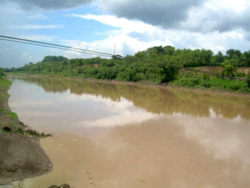
Solo River
The Solo River (known in Indonesian as the Bengawan Solo, with Bengawan being an Old Javanese word for river, and Solo derived from the old name for Surakarta) is the longest river in the Indonesian island of Java. It is approximately 600 km (370 mi) in length.
Apart from its importance as a watercourse to the inhabitants and farmlands of the eastern and northern parts of the island, it is a renowned region in paleoanthropology circles. Many discoveries of early hominid remains (dating from 100,00 to 1.5 million years ago) have been made at several sites in its valleys, especially at Sangiran, including that of the first early human fossil found outside of Europe, the so-called "Java Man" skull, discovered in 1891.
The Bengawan Solo was the crash site of Garuda Indonesia Flight 421 on January 16, 2002.
Solo River was part of a massive river system that once existed in Sundaland. This drainage of the river system consisted of a major river in present-day Sumatra and Borneo, such as the Asahan River, Musi River and Kapuas River. The river system disappeared when Sundaland was submerged after sea level rise following the last Ice Age.
The river played an important part in Javanese history. Its drainage basin is an important agricultural area, dominated by rice farming. The river transported fertile volcanic soil downstream, replenishing the soil. It also provided a link between Javanese port cities on the northern coast and the rice-growing hinterlands, with shallow vessels transporting rice to the ports to be sold. This rice is Java's main commodity that was traded as part of the Spice trade.
Following the acquisition of much of Java by the Dutch colonial government, various cash crops were introduced to be planted across the river basin, such as coffee, sugar, and cotton. (see Cultivation System).
By the last years of the 19th century, river sedimentation in its original delta in Madura Strait started to disrupt vessel traffic in the port of Surabaya. The Dutch colonial government decided to divert the river flow away from the shipping lane into the Java Sea. They built a canal in the river's delta in the 1890s which still alters the river to this day.
In 1891, Dutch paleoanthropologist Eugène Dubois discovered remains (a part of a skull and human-like femur bone and tooth) he described as "a species in between humans and apes". He called his finds Pithecanthropus erectus ("ape-human that stands upright") or Java Man. Today, they are classified as Homo erectus ("human that stands upright"). These were the first specimens of early hominid remains to be found outside of Africa or Europe.
Hub AI
Solo River AI simulator
(@Solo River_simulator)
Solo River
The Solo River (known in Indonesian as the Bengawan Solo, with Bengawan being an Old Javanese word for river, and Solo derived from the old name for Surakarta) is the longest river in the Indonesian island of Java. It is approximately 600 km (370 mi) in length.
Apart from its importance as a watercourse to the inhabitants and farmlands of the eastern and northern parts of the island, it is a renowned region in paleoanthropology circles. Many discoveries of early hominid remains (dating from 100,00 to 1.5 million years ago) have been made at several sites in its valleys, especially at Sangiran, including that of the first early human fossil found outside of Europe, the so-called "Java Man" skull, discovered in 1891.
The Bengawan Solo was the crash site of Garuda Indonesia Flight 421 on January 16, 2002.
Solo River was part of a massive river system that once existed in Sundaland. This drainage of the river system consisted of a major river in present-day Sumatra and Borneo, such as the Asahan River, Musi River and Kapuas River. The river system disappeared when Sundaland was submerged after sea level rise following the last Ice Age.
The river played an important part in Javanese history. Its drainage basin is an important agricultural area, dominated by rice farming. The river transported fertile volcanic soil downstream, replenishing the soil. It also provided a link between Javanese port cities on the northern coast and the rice-growing hinterlands, with shallow vessels transporting rice to the ports to be sold. This rice is Java's main commodity that was traded as part of the Spice trade.
Following the acquisition of much of Java by the Dutch colonial government, various cash crops were introduced to be planted across the river basin, such as coffee, sugar, and cotton. (see Cultivation System).
By the last years of the 19th century, river sedimentation in its original delta in Madura Strait started to disrupt vessel traffic in the port of Surabaya. The Dutch colonial government decided to divert the river flow away from the shipping lane into the Java Sea. They built a canal in the river's delta in the 1890s which still alters the river to this day.
In 1891, Dutch paleoanthropologist Eugène Dubois discovered remains (a part of a skull and human-like femur bone and tooth) he described as "a species in between humans and apes". He called his finds Pithecanthropus erectus ("ape-human that stands upright") or Java Man. Today, they are classified as Homo erectus ("human that stands upright"). These were the first specimens of early hominid remains to be found outside of Africa or Europe.