



Community hub
Tiksi
View on Wikipedia
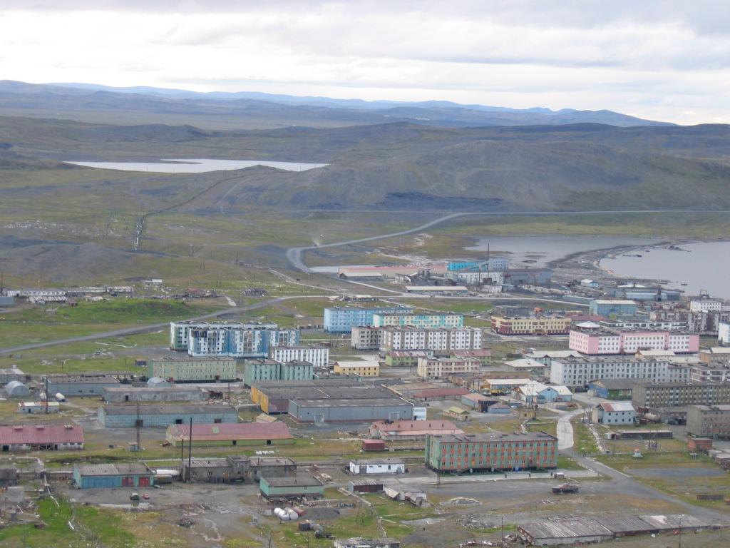
Tiksi (Russian: Ти́кси, IPA: [ˈtʲiksʲɪ]; Yakut: Тиксии, Tiksii – lit. a moorage place) is an urban locality (an urban-type settlement) and the administrative center of Bulunsky District in the Sakha Republic, Russia, located on the shore of the Buor-Khaya Gulf of the Laptev Sea, southeast of the delta of the Lena River. As of the 2010 census, its population was 5,063.[3]
Key Information


| Year | Pop. | ±% |
|---|---|---|
| 1939 | 697 | — |
| 1959 | 4,833 | +593.4% |
| 1970 | 8,099 | +67.6% |
| 1979 | 9,505 | +17.4% |
| 1989 | 11,649 | +22.6% |
| 2002 | 5,873 | −49.6% |
| 2010 | 5,063 | −13.8% |
| 2021 | 4,173 | −17.6% |
| Source: Census data | ||
History
[edit] | This section needs additional citations for verification. (September 2022) |
In August 1901, Russian Arctic ship Zarya headed across the Laptev Sea, searching for the legendary Sannikov Land but was soon blocked by floating drift ice in the New Siberian Islands. During 1902, the attempts to reach Sannikov Land continued while Zarya was trapped in fast ice.
Leaving the ship, Russian Arctic explorer Baron Eduard Toll and three companions vanished forever in November 1902 while traveling away from Bennett Island towards the south on loose ice floes. Zarya was finally moored close to Brusneva Island in the Tiksi Bay, never to leave the place again. The remaining members of the expedition returned to Saint Petersburg, while Captain Fyodor Matisen went to Yakutsk.
Modern Tiksi was founded in 1933;[citation needed] urban-type settlement status was granted to it in 1939.[2] During the Cold War, Tiksi saw military construction projects at Tiksi North and Tiksi West airfields. Since the dissolution of the Soviet Union, Tiksi's population has declined markedly and many of its apartment blocks have been abandoned. Despite its rapid population decline, it remains the world's most northerly settlement with a population of over 4,000.
Administrative and municipal status
[edit]Within the framework of administrative divisions, the urban-type settlement of Tiksi[1] serves as the administrative center of Bulunsky District.[2] As an administrative division, it is incorporated within Bulunsky District as the Settlement of Tiksi.[2] As a municipal division, the Settlement of Tiksi is incorporated within Bulunsky Municipal District as Tiksi Urban Settlement.[5]
Economy
[edit]Transportation
[edit]Tiksi serves as one of the principal ports for accessing the Laptev Sea. It is served by the Tiksi Airport, which was shut down by the Defense Ministry on October 1, 2012 except for helicopters.[9] Tiksi was connected only by helicopter flights and winter roads. The closure was harshly criticized by Russian Prime Minister Dmitry Medvedev. Following an agreement between the Defense Ministry and the Government of the Sakha Republic in April 2013, the airfield re-opened to passenger traffic in June 2013. In December 2013, President Vladimir Putin announced that the Tiksi airport would be "rehabilitated" along with others beyond the Arctic Circle.[10]
Since June 2023, the port of Tiksi has been opened to foreign ships.[11]
The Lena River is navigable in the summer months. There is infrequent passenger navigation from Yakutsk.
Climate
[edit]Tiksi has a tundra climate (Köppen ET). Winter averages and extremes are less severe than the subarctic region further south, but the winter length is longer courtesy of the higher latitude. The very short summers are generally cooler than inland regions (although in 1991 a temperature as high as +34 °C (93 °F) was reported) and see rainfall on most days. The polar night lasts from November 19 to January 24, and the period with continuous daylight, the midnight sun, lasts a bit longer, from May 11 to August 3.
The growing season in Tiksi lasts for 74 days usually from around June 23 to September 5.[12]
| Climate data for Tiksi (1991–2020 normals, extremes 1929–present) | |||||||||||||
|---|---|---|---|---|---|---|---|---|---|---|---|---|---|
| Month | Jan | Feb | Mar | Apr | May | Jun | Jul | Aug | Sep | Oct | Nov | Dec | Year |
| Record high °C (°F) | −7.6 (18.3) |
−5.2 (22.6) |
1.6 (34.9) |
9.6 (49.3) |
23.6 (74.5) |
32.8 (91.0) |
34.3 (93.7) |
29.8 (85.6) |
23.0 (73.4) |
6.1 (43.0) |
−1.2 (29.8) |
−4.9 (23.2) |
34.3 (93.7) |
| Mean daily maximum °C (°F) | −25.9 (−14.6) |
−26.6 (−15.9) |
−21.3 (−6.3) |
−12.1 (10.2) |
−2.2 (28.0) |
8.0 (46.4) |
12.7 (54.9) |
11.6 (52.9) |
4.8 (40.6) |
−7.0 (19.4) |
−18.7 (−1.7) |
−24.7 (−12.5) |
−8.4 (16.8) |
| Daily mean °C (°F) | −29.5 (−21.1) |
−30.0 (−22.0) |
−25.4 (−13.7) |
−16.8 (1.8) |
−5.6 (21.9) |
3.8 (38.8) |
8.3 (46.9) |
8.4 (47.1) |
2.2 (36.0) |
−9.7 (14.5) |
−22.0 (−7.6) |
−28.1 (−18.6) |
−12.0 (10.3) |
| Mean daily minimum °C (°F) | −33.1 (−27.6) |
−33.7 (−28.7) |
−29.9 (−21.8) |
−22.1 (−7.8) |
−9.1 (15.6) |
0.6 (33.1) |
4.7 (40.5) |
5.2 (41.4) |
−0.5 (31.1) |
−13.1 (8.4) |
−25.5 (−13.9) |
−31.5 (−24.7) |
−15.7 (3.8) |
| Record low °C (°F) | −48.0 (−54.4) |
−50.5 (−58.9) |
−47.2 (−53.0) |
−46.9 (−52.4) |
−32.2 (−26.0) |
−15.8 (3.6) |
−4.0 (24.8) |
−4.0 (24.8) |
−18.2 (−0.8) |
−35.0 (−31.0) |
−43.9 (−47.0) |
−48.8 (−55.8) |
−50.5 (−58.9) |
| Average precipitation mm (inches) | 22 (0.9) |
15 (0.6) |
10 (0.4) |
8 (0.3) |
15 (0.6) |
28 (1.1) |
45 (1.8) |
48 (1.9) |
27 (1.1) |
15 (0.6) |
19 (0.7) |
21 (0.8) |
273 (10.8) |
| Average rainy days | 0.0 | 0.0 | 0.0 | 0.0 | 1 | 12 | 20 | 20 | 9 | 0.1 | 0.0 | 0.0 | 62.1 |
| Average snowy days | 23 | 21 | 21 | 19 | 20 | 5 | 0.2 | 0.3 | 10 | 25 | 23 | 23 | 190.5 |
| Average relative humidity (%) | 82 | 82 | 83 | 83 | 85 | 82 | 83 | 83 | 82 | 83 | 82 | 81 | 83 |
| Mean monthly sunshine hours | 0.0 | 40.0 | 176.9 | 276.5 | 199.0 | 238.2 | 246.4 | 132.6 | 86.8 | 52.9 | 4.0 | 0.0 | 1,453.3 |
| Source 1: погода и климат[13] | |||||||||||||
| Source 2: (sunshine only)[14] | |||||||||||||
| Coastal temperature data for Tiksi | |||||||||||||
|---|---|---|---|---|---|---|---|---|---|---|---|---|---|
| Month | Jan | Feb | Mar | Apr | May | Jun | Jul | Aug | Sep | Oct | Nov | Dec | Year |
| Average sea temperature °C (°F) | −1.8 (28.76) |
−1.8 (28.76) |
−1.8 (28.76) |
−1.8 (28.76) |
−1.5 (29.3) |
.4 (32.72) |
3.9 (39.02) |
7.6 (45.68) |
4.8 (40.64) |
0.7 (30.74) |
−1.7 (28.94) |
−1.8 (28.76) |
0.317 (32.57) |
| Source:[15] | |||||||||||||
References
[edit]Notes
[edit]- ^ a b According to Article 7 of the Law #77-I, lower-level administrative divisions with the status of a settlement have their administrative centers in an inhabited locality with the status of an urban-type settlement. According to the Registry of the Administrative-Territorial Divisions of the Sakha Republic, Tiksi is the administrative center of the Settlement of Tiksi.
- ^ a b c d e f g h i Registry of the Administrative-Territorial Divisions of the Sakha Republic
- ^ a b Russian Federal State Statistics Service (2011). Всероссийская перепись населения 2010 года. Том 1 [2010 All-Russian Population Census, vol. 1]. Всероссийская перепись населения 2010 года [2010 All-Russia Population Census] (in Russian). Federal State Statistics Service.
- ^ Sakha Republic (Yakutia) Territorial Branch of the Federal State Statistics Service. Численность населения по районам республики на 1 января 2016 года Archived September 29, 2018, at the Wayback Machine Population of the districts of the republic on January 1, 2016 (in Russian)
- ^ a b c d Law #173-Z #353-III
- ^ Law #172-Z #351-III
- ^ "Об исчислении времени". Официальный интернет-портал правовой информации (in Russian). June 3, 2011. Retrieved January 19, 2019.
- ^ Почта России. Информационно-вычислительный центр ОАСУ РПО. (Russian Post). Поиск объектов почтовой связи (Postal Objects Search) (in Russian)
- ^ Якутский аэропорт Тикси закрыт для приёма и отправки рейсов до декабря, причины не названы. Газета.ru (in Russian). Moscow. October 3, 2012. Retrieved October 4, 2012.
- ^ "Putin orders Arctic military boost". BBC News. December 11, 2013. Retrieved August 2, 2018.
- ^ "Arctic Port of Tiksi Opens to Foreign Vessels To Spur Investments along NSR". High North News. June 5, 2023.
- ^ "Average Weather in Tiksi, Russia, Year Round - Weather Spark".
- ^ Погода в Тикси
- ^ "Tiksi, Russia Travel Weather Averages (Weatherbase)". Weatherbase. Retrieved August 2, 2018.
- ^ "Температура воды в Тикси сейчас. Средняя температура воды в море по месяцам. Ежедневные показатели за 2020-2021 год".
Sources
[edit]- Official website of the Sakha Republic. Registry of the Administrative-Territorial Divisions of the Sakha Republic. Bulunsky District Archived April 27, 2017, at the Wayback Machine. (in Russian)
- Государственное Собрание (Ил Тумэн) Республики Саха (Якутия). Закон №172-З №351-III от 30 ноября 2004 г. «Об установлении границ и о наделении статусом муниципального района муниципальных образований Республики Саха (Якутия)», в ред. Закона №1535-З №597-V от 27 ноября 2015 г. «О внесении изменений в статьи 1 и 2 Закона Республики Саха (Якутия) "Об установлении границ и о наделении статусом муниципального района муниципальных образований Республики Саха (Якутия)"». Вступил в силу со дня официального опубликования. Опубликован: "Якутия", №245, 31 декабря 2004 г. (State Assembly (Il Tumen) of the Sakha (Yakutia) Republic. Law #172-Z No. 351-III of November 30, 2004 On Establishing the Borders and on Granting the Municipal District Status to the Municipal Formations of the Sakha (Yakutia) Republic, as amended by the Law #1535-Z No. 597-V of November 27, 2015 On Amending Articles 1 and 2 of the Law of the Sakha (Yakutia) Republic "On Establishing the Borders and on Granting the Municipal District Status to the Municipal Formations of the Sakha (Yakutia) Republic". Effective as of the day of the official publication.).
- Государственное Собрание (Ил Тумэн) Республики Саха (Якутия). Закон №173-З №353-III от 30 ноября 2004 г. «Об установлении границ и о наделении статусом городского и сельского поселений муниципальных образований Республики Саха (Якутия)», в ред. Закона №1058-З №1007-IV от 25 апреля 2012 г. «О внесении изменений в Закон Республики Саха (Якутия) "Об установлении границ и о наделении статусом городского и сельского поселений муниципальных образований Республики Саха (Якутия)"». Вступил в силу со дня официального опубликования. Опубликован: "Якутия", №245, 31 декабря 2004 г. (State Assembly (Il Tumen) of the Sakha (Yakutia) Republic. Law #173-Z No. 353-III of November 30, 2004 On Establishing the Borders and on Granting the Urban and Rural Settlement Status to the Municipal Formations of the Sakha (Yakutia) Republic, as amended by the Law #1058-Z No. 1007-IV of April 25, 2012 On Amending the Law of the Sakha (Yakutia) Republic "On Establishing the Borders and on Granting the Urban and Rural Settlement Status to the Municipal Formations of the Sakha (Yakutia) Republic". Effective as of the day of the official publication.).
Further reading
[edit]- Barr, William (1981). "Baron Eduard von Toll's Last Expedition: The Russian Polar Expedition, 1900–1903". Arctic. 34 (3): 201–224. doi:10.14430/arctic2524.

.svg)

| International | |
|---|---|
| National | |
Tiksi
View on GrokipediaThe settlement's population has significantly declined since the Soviet Union's dissolution, from over 11,000 in the late 1980s to around 4,440 as of 2023, reflecting reduced economic activity and infrastructure abandonment amid the post-Cold War diminishment of its strategic role.[4] [5] Recent efforts by Russian authorities, including designating Tiksi an international port open to foreign vessels in 2023, aim to revive its function as a cargo hub for Northern Sea Route traffic, leveraging its proximity to the Lena River delta for resource exports and Arctic development.[6] [7] Despite these initiatives, the town contends with extreme subarctic climate conditions, coastal erosion exacerbated by climate change, and isolation that challenge sustainable habitation and operations.[8] [9]
Geography
Location and Physical Features
Tiksi is situated in the Bulunsky District of the Sakha Republic, Russia, on the eastern shore of Tiksi Bay, a narrow inlet within the Buor-Khaya Gulf of the Laptev Sea.[10] The town lies approximately 100 kilometers east of the Lena River Delta, sheltered by the Bykovsky Peninsula to the west, which mitigates exposure to open Arctic waters.[11] Its geographic coordinates are 71°39′N 128°52′E, positioning it well north of the Arctic Circle in a remote coastal Arctic setting.[12] The physical landscape surrounding Tiksi consists of low-elevation coastal plains dominated by continuous permafrost, with mean annual ground temperatures around -7.5°C at depths of 2 meters. The terrain features flat tundra expanses interspersed with thermokarst lakes and polygonal ground patterns typical of ice-rich permafrost zones, extending inland toward yedoma ice complexes on the adjacent Buor Khaya Peninsula. Elevations remain minimal, rarely exceeding 50 meters above sea level, supporting sparse Arctic vegetation adapted to extreme cold and short growing seasons.[13] The coastal position facilitates ice-covered seas for much of the year, influencing local geomorphology through seasonal freeze-thaw cycles and shoreline dynamics.[14]Coastal and Permafrost Environment
Tiksi lies on the western shore of the Buor-Khaya Gulf in the Laptev Sea, an arm of the Arctic Ocean characterized by extensive seasonal sea ice cover that typically persists from October to June, with reduced fast ice duration due to climate warming exacerbating coastal exposure to wave action.[15] The gulf receives substantial terrigenous sediments from the nearby Lena River Delta, influencing local hydrology and supporting a brackish ecosystem with stratified water columns where freshwater inputs create distinct layers.[16] Coastal morphology has evolved significantly over the past 50 years, with shoreline length and fractal dimension increasing due to combined effects of human infrastructure development, such as port facilities, and climatic factors including shorter ice seasons and intensified erosion rates.[9] Permafrost in the Tiksi region forms part of the continuous permafrost zone, where ground temperatures remain below 0°C for at least two years, underlying approximately 90% or more of the landscape and reaching depths exceeding 300 meters in undisturbed areas.[17] Climate warming has induced permafrost thaw, manifesting in surface subsidence rates at infrastructure sites like Tiksi Airport, with interferometric synthetic aperture radar (InSAR) measurements indicating localized deformation velocities from -42 to 39 mm/year between 2017 and 2023, primarily driven by rising land surface temperatures and thaw-induced ground instability.[18] This degradation destabilizes landscapes through increased cryogenic processes, such as thermokarst formation and active layer thickening, which amplify hazards like slumping and infrastructure damage, as evidenced by 30 years of thermal monitoring showing gradual permafrost temperature rises in the eastern Russian Arctic.[19][20] Interactions between coastal dynamics and permafrost are pronounced, as reduced sea ice and prolonged open-water periods enhance thermodenudation and abrasion along the Tiksi shoreline, with erosion rates accelerating under warming conditions in the Lena Delta vicinity, contributing to habitat shifts and potential release of organic carbon from degrading submarine permafrost.[21] These processes pose risks to local ecology, including altered sediment transport affecting benthic communities in the Buor-Khaya Gulf, where organic matter decomposition in thawing sediments has been linked to elevated greenhouse gas production.[22]History
Early Settlement and Indigenous Presence
The coastal regions of the Laptev Sea, including the area now encompassing Tiksi in the Bulunsky District of the Sakha Republic, have supported indigenous Siberian populations for thousands of years through seasonal exploitation of marine and terrestrial resources. Archaeological and ethnographic evidence points to the Yukaghirs as among the earliest inhabitants, a Paleosiberian group adapted to tundra and taiga environments east of the Lena River, where they relied on hunting, fishing, and gathering for subsistence.[23] Tungusic-speaking peoples, including the Evenks and Evens, subsequently established historical presence in the Laptev Sea vicinity, migrating into Arctic Yakutia and maintaining semi-nomadic economies centered on reindeer herding, coastal fishing, and hunting of marine mammals such as seals. These groups utilized the shoreline for temporary camps during migrations and resource harvests, with populations documented in the broader East Siberian Arctic by the 17th century, numbering around 19,000 Tungus (including Evenks and Evens) across Yakutia and adjacent areas.[23][24][25] In the Bulunsky District specifically, these indigenous traditions persisted among Evenks, Evens, and to a lesser extent Yukaghirs, with rural settlements emphasizing fishing-oriented livelihoods predating extensive Russian influence. The Turkic Sakha (Yakuts) exerted demographic pressure through northward expansion starting around the 13th–15th centuries, but smaller northern indigenous groups retained coastal territories for their specialized Arctic adaptations. No evidence indicates permanent pre-20th-century non-indigenous settlements at the Tiksi site itself, which remained peripheral to early Russian explorations limited to riverine and overland routes from the 17th century onward.[26][27][28]Soviet Industrialization and Port Development
The settlement of Tiksi was established in 1932 as a strategic port along the Northern Sea Route (NSR) amid the Soviet Union's campaign to explore, colonize, and industrialize the Arctic region.[29] This development aligned with broader Five-Year Plans emphasizing resource extraction, maritime navigation, and infrastructure in remote northern territories to support national economic goals.[30] By 1933, initial construction near an existing polar station laid the groundwork for port facilities, including wharves and storage depots essential for transshipping goods from the Lena River delta to coastal vessels.[2] Port infrastructure expanded rapidly, with the harbor terminal completed by 1938, enabling year-round operations limited only by ice conditions and facilitating coal, timber, and supply shipments critical to Arctic outposts.[9] Soviet authorities prioritized Tiksi for its position at the Laptev Sea entrance, integrating it into Glavsevmorput—the Main Directorate of the Northern Sea Route—which coordinated vessel convoys, icebreaker support, and repair yards to sustain NSR traffic volumes exceeding 1 million tons annually by the late 1930s.[31] Industrial facilities followed, including sawmills, house-building plants, and an oil refinery, alongside agricultural experiments like greenhouses and a dairy to provision remote workers, reflecting centralized planning to achieve self-sufficiency in harsh permafrost environments.[2] During the Great Patriotic War (1941–1945), Tiksi served as a vital convoy base for the western Soviet Arctic, handling Allied Lend-Lease shipments and domestic logistics despite submarine threats and ice impediments, underscoring its dual civilian-military role.[32] Postwar reconstruction amplified port capacity, with dredging and quay extensions supporting mechanized loading for bulk cargoes tied to Sakha's mining boom, including diamonds and metals.[30] By the 1980s, at the NSR's Soviet peak, Tiksi processed approximately 25% of Yakutia's inbound freight—up to several million tons yearly—while sustaining a population surge to over 12,000 through state-subsidized housing and utilities, though environmental challenges like coastal erosion began eroding long-term viability.[33] This era's infrastructure, built via forced labor and rapid mobilization, entrenched Tiksi's dependence on state directives rather than market dynamics.[29]Post-Soviet Economic Shifts and Population Changes
Following the dissolution of the Soviet Union in 1991, Tiksi underwent profound economic contraction as state subsidies for Arctic infrastructure and shipping ceased, leading to a sharp reduction in Northern Sea Route (NSR) cargo volumes that fell to approximately 5% of 1980s levels, where annual throughput had reached around 900,000 tons.[30] The port, once a key hub for freight destined for inland Sakha Republic destinations comprising 25% of NSR traffic in its peak Soviet years, saw diminished operations due to the collapse of centralized planning and reduced demand for resource extraction support, exacerbating unemployment among former port workers, military personnel, and logistics specialists.[30] Military base closures in the 1990s further eroded the town's economic base, as Tiksi had relied heavily on defense-related activities that employed a significant portion of residents.[30] This economic downturn triggered massive outmigration, with Tiksi's population plummeting from over 11,000 in 1989 to 5,063 by the 2010 Russian census, representing a loss of more than half its inhabitants between 1990 and 2014 primarily through the departure of ethnic Russian and other non-indigenous specialists seeking opportunities in southern Russia or Yakutsk.[30] [26] The exodus stabilized somewhat by the early 2000s due to inflows from nearby indigenous villages and limited local adaptations, such as small-scale fishing operations processing up to 200,000 tons annually and support for diamond mining activities yielding $39.1 million in profits in 2013.[30] However, the population continued a gradual decline to 4,440 by 2023, reflecting persistent challenges like infrastructure decay and isolation, despite federal rhetoric on NSR revival.[5] Emerging economic niches have provided partial mitigation, including the collection and export of mammoth tusks—facilitated by permafrost thaw—with 58 licenses issued in 2011 and an estimated 61 tons available from the New Siberian Islands, alongside ongoing energy production and scientific research at facilities like the Tiksi Hydrometeorological Observatory.[30] Russian government initiatives since the 2010s, including military base reopenings and NSR modernization plans, have sustained a baseline economy through defense contracts, but the port remains far below Soviet-era functionality, with hopes for renewed shipping largely unrealized amid geopolitical isolation and high operational costs.[28] [34] These shifts have altered demographics, increasing the proportion of indigenous groups like Evenkis (25%) and Sakha (23.4%) relative to Russians (29%) by 2016, as non-indigenous outmigration outpaced overall decline.[30]Administrative and Demographic Profile
Governance and Administrative Status
Tiksi is classified as an urban-type settlement (посёлок городского типа) within the Bulunsky Ulus (district) of the Sakha Republic, a federal subject of Russia, and serves as the administrative center of both the Tiksi Urban Settlement and the wider Bulunsky District.[35] This status reflects its role as the primary urban hub in a predominantly rural and indigenous-inhabited district, with local governance focused on coordinating essential services amid Arctic isolation.[26] The urban-type designation, typical for smaller Russian localities with urban infrastructure but not full city status, was formalized in 1939 following its establishment as a port in 1933.[36] Municipally, Tiksi is incorporated as the Tiksi Urban Settlement (Городское поселение "Посёлок Тикси"), a self-governing entity under Russian federal law on local self-government, handling matters such as utilities, education, and emergency response while reporting to the Bulunsky Municipal District administration.[37] The settlement's administrative body, established in its current form by 2005, operates from facilities on Trusova Street and integrates with district-level oversight to address regional challenges like permafrost infrastructure and seasonal accessibility.[38] Ultimate authority aligns with the Sakha Republic's presidential system, where the republic's head exerts influence over northern districts through development plans, including Arctic-specific funding allocations up to 2025.[39] As the sole urban settlement in Bulunsky Ulus, Tiksi's governance emphasizes resilience to environmental and logistical constraints, with local decisions often requiring coordination with Yakutsk-based republican structures for resource allocation and federal programs.[30] This layered hierarchy ensures compliance with national policies on Arctic development while permitting limited local autonomy in daily administration.[40]Population Dynamics and Ethnic Composition
As of the 2010 Russian census, Tiksi's population stood at 5,063 residents.[26] By the 2021 census, this figure had decreased to 4,173, reflecting an annual population change of -1.8% from 2010 to 2021.[41] This decline aligns with broader post-Soviet depopulation trends in Arctic Russian settlements, where the dissolution of the Soviet Union led to reduced economic activity, including diminished port operations and military presence, prompting significant outmigration.[30] Estimates indicate that more than half of the local population departed between 1990 and 2014, primarily non-indigenous groups such as Russians, Ukrainians, Armenians, and Germans who had migrated during the Soviet era for high-wage industrial and logistical roles.[26][42] Recent data suggest a potential stabilization, with the population estimated at 4,440 in 2023, though official census figures confirm ongoing net loss driven by harsh climatic conditions, limited infrastructure, and economic peripheralization.[5] Factors contributing to these dynamics include the closure of Soviet-era facilities, which once supported a larger transient workforce, and the challenges of permafrost thaw exacerbating housing and transport issues, deterring inflows.[30] Despite this, Tiksi retains a role as the administrative and transport hub for Bulunsky District, mitigating total abandonment seen in nearby ghost settlements. The ethnic composition of Tiksi is predominantly Slavic, with residents mainly consisting of Russians and Ukrainians, reflecting its history as a Soviet-developed port attracting migrant labor from European Russia.[26] This contrasts with rural areas in Bulunsky District, where indigenous groups such as Evenks (27.4%), Yakuts (24.6%), and Evens (13.4%) form larger shares alongside Russians (28.8%). Post-Soviet outmigration disproportionately affected non-indigenous populations, yet Tiksi's urban character has preserved a majority Slavic demographic, with indigenous presence limited compared to the Sakha Republic's overall composition of 55.3% Sakha (Yakuts) and 32.6% Russians as of 2010.[42] Detailed census breakdowns for Tiksi specifically highlight this Slavic dominance, underscoring the town's role as an enclave of Russian settler culture amid indigenous northern territories.[26]Economy
Primary Economic Sectors
Tiksi's economy is predominantly anchored in maritime transport and port operations, with the local seaport serving as a critical node on the Northern Sea Route for Arctic shipping and logistics. Established during the Soviet era, the port facilitates cargo handling, vessel servicing, and regional connectivity, though it has faced underutilization post-1991 due to economic transitions and infrastructure decay. Recent federal initiatives, including reconstruction projects outlined in development plans through 2025, seek to revitalize these operations by improving capacity for increased Northern Sea Route traffic amid Russia's push for Arctic resource extraction and export routes.[34][43] Fishing constitutes another foundational sector, drawing on the Laptev Sea's resources and supporting both commercial and subsistence activities in the Bulunsky District, where Tiksi acts as the primary administrative and processing hub. Local fleets target species like polar cod and whitefish, but quotas and environmental pressures, including climate-driven stock declines, have strained viability, prompting debates over sustainable management. District-wide, fishing integrates with indigenous practices, though Tiksi's urban focus emphasizes logistical support over direct harvesting.[44][40] Subsidiary activities include exploratory mining for regional hydrocarbons, coal, and diamonds, alongside limited service industries tied to transportation and administration, but these yield lower direct employment compared to port and fishery functions. Federal subsidies and master plans, such as the Tiksi-Nayba agglomeration strategy, prioritize infrastructure to bolster these sectors against permafrost thaw and isolation, aiming for socio-economic stabilization by enhancing defense-related logistics and emergency services.[40][43]Transportation Infrastructure and Port Operations
Tiksi's primary transportation infrastructure revolves around its seaport and airport, serving as vital nodes in the Arctic logistics network due to the region's remoteness and lack of extensive road or rail connections. The port, situated in the Buor-Khaya Gulf on the Laptev Sea, functions as a general-purpose facility on the Northern Sea Route (NSR), handling cargo transshipment for regional supply chains.[34] Navigation is seasonally restricted, typically feasible from July to November during the summer ice-free period, with icebreaker assistance required for reliable access.[45] Cargo operations focus on general freight, including bulk goods transferred to river vessels for inland distribution via the Lena River, though shallow drafts—often limiting vessels to under 10 meters—constrain handling of larger ships and contribute to infrastructural decline.[34] As of 2017, annual capacity stood at approximately 67,000 tons, supported by nine mooring points, eight dedicated to general cargo.[46] Port operations have historically emphasized domestic Russian supply, exporting minerals and timber while importing fuel, equipment, and provisions, but face challenges such as outdated equipment and vulnerability to oil spills, identified as a foundational logistics risk in structural modeling analyses.[34] In June 2023, Tiksi was redesignated an international port open to foreign vessels to attract investment and enhance NSR throughput, with ambitions to develop it as a transshipment hub for raw materials and cruise traffic.[6] Russian federal plans project expansion to 30 million tons annual cargo turnover by the 2030s, including a proposed deepwater facility near Nayba capable of 10-meter draft vessels, integrated with Lena River routes and distant rail links like the Trans-Siberian for broader connectivity.[6] However, current limitations in modern handling gear and land-based extensions persist, with general-purpose NSR ports like Tiksi lacking state-backed development compared to specialized facilities.[47] Complementing maritime access, Tiksi Airport (IATA: IKS, ICAO: UEST) provides air connectivity, featuring a single 3,100-meter by 60-meter runway built in the 1950s originally as a staging base for Soviet long-range aviation.[48] Operated jointly for civilian and military purposes under Russian Aerospace Forces oversight, it supports limited scheduled passenger flights, such as Antonov An-24 services offering around 50 daily seats, alongside cargo and research transport.[49] Military infrastructure includes hangars and support for heavy bomber units, though expansion announcements for additional facilities like dormitories have seen minimal equipment deployment as of recent assessments.[48] Ground transport remains underdeveloped, with no direct rail lines; access relies on seasonal roads prone to permafrost disruption and river barging, underscoring Tiksi's dependence on air and sea for year-round viability.[47]Climate and Environmental Conditions
Climatic Patterns and Data
Tiksi exhibits a polar tundra climate (Köppen ET), characterized by long, frigid winters with subzero temperatures persisting for much of the year, brief cool summers, low annual precipitation, and extreme diurnal and seasonal light variations due to its high Arctic latitude. Average temperatures fluctuate dramatically, from a January mean of approximately -29°C to a July mean of about 8°C, with absolute minima occasionally dipping below -40°C and rare summer maxima surpassing 20°C.[50][51] Precipitation totals around 200 mm equivalent annually, with the wetter period spanning May to September (peaking at 51 mm in July, mostly as rain) and the remainder falling as snow from late September through May. Snow cover endures for about eight months, accumulating up to 150 cm depth in spring before partial melt. The climate features high winter humidity (often exceeding 90%), frequent overcast skies (up to 93% cloud cover in January), and prevailing westerly winds gusting to 20-25 km/h, moderated somewhat by proximity to the Laptev Sea.[50][52]| Month | Average High (°C) | Average Low (°C) | Precipitation (mm, water equiv.) |
|---|---|---|---|
| January | -26 | -32 | 8 (mostly snow) |
| February | -26 | -31 | 5 (mostly snow) |
| March | -21 | -27 | 10 (mostly snow) |
| April | -13 | -20 | 38 (mostly snow) |
| May | -3 | -8 | 17 (mixed) |
| June | 7 | 1 | 31 (mixed) |
| July | 11 | 5 | 51 (rain) |
| August | 10 | 5 | 43 (rain) |
| September | 3 | -1 | 20 (mixed) |
| October | -8 | -13 | 6 (mixed) |
| November | -19 | -25 | 4 (snow) |
| December | -24 | -30 | 15 (snow) |