

Community hub
Recent from talks
Contribute something
Nothing was collected or created yet.
Utsjoki
View on WikipediaUtsjoki (Finnish: [ˈutsjoki]; Northern Sami: Ohcejohka [ˈoht͡seˌjohka]; Inari Sami: Uccjuuhâ; Skolt Sami: Uccjokk; Norwegian: Utsjok) is a municipality in Finland, the northernmost in the country. It is in Lapland and borders Norway as well as the municipality of Inari. The municipality was founded in 1876. It has a population of 1,127 (30 June 2025)[2] and covers an area of 5,372.00 square kilometres (2,074.14 sq mi) of which 227.51 km2 (87.84 sq mi) is water.[1] The population density is 0.22 inhabitants per square kilometre (0.57/sq mi).
Key Information


Utsjoki has two official languages: Finnish and Northern Sami. It is the municipality in Finland with the largest portion of official Sami speakers; 41.6% of the population.[3] Ethnically, 54.6% of the population were Sami in 2019, making Utsjoki the only municipality in Finland with Sami majority.[6]
The border with Norway follows the river Teno, which flows into the Arctic Sea. The northernmost village in Finland and in the European Union is Nuorgam.
Utsjoki is at the northern end of highway 4, the longest highway in Finland. The European route E75 runs along the Sami Bridge and continues on to Norway.[citation needed]
The Kevo nature reserve is located within the municipality. It covers a territory of 712 km2 (275 sq mi) and there is a 63 km (39 mi) hiking trail. The trail partly follows the edge of the Kevo gorge.[citation needed]
"The name Utsjoki comes from Northern Sami Ohcejohka, but the origin of that name is unknown", according to website Fennica.pohjoiseen.fi.[7]
Geography
[edit]Villages
[edit]- Nuorgam
- Utsjoki centre
- Nuvvus
- Dalvadas
- Outakoski
- Rovisuvanto
- Karigasniemi
- Kaamasmukka
Topography
[edit]The Utsjoki region is flatter and lower in altitudes than many other parts of Lapland. Large areas of Utsjoki are less than 300 m above sea level. Many of the fell summits are under 500 m in height. In general, the topography is smooth and the fells slope gently. The summits are very flat and large, as is typical of old peneplain surfaces.
Vegetation
[edit]In general, the tree line is located at altitudes between 300 and 400 meters. In northernmost Finland, the tree line on north-facing slopes is just above an altitude of 100 meters. Heaths extend above the tree line. The lower heathlands are dominated by shrubs such as dwarf birch, blueberry and crowberry, whereas the fells, at higher elevations, have dwarf willows and alpine grasses with lichens and mosses. On the fell tops, blockfields and windblown heaths with lichens and mosses as well as bare rock slabs are found. Patterned ground occurs regularly, often as polygons and stone stripes on the slopes.
Climate
[edit]The midnight sun remains above the horizon from 17 May to 28 July (73 days), and the polar night from 26 November to 15 January (51 days). Utsjoki, like most of Finland, has a subarctic climate (Köppen Dfc, Trewartha Eclc. Being the northernmost municipality in Finland, Utsjoki's annual average temperature is below freezing. Utsjoki is also the driest place in Finland, as the average annual precipitation varies between 371 and 433 mm, depending on the topography. The driest year on record was 1986, when only 234 mm of precipitation fell at the Outakoski weather station.[8]
Extremely low temperatures and low precipitation result in thin snow cover throughout the winters. The wind velocity strongly increases with higher elevations, and this has a major effect on the distribution of the snow. The exposed hilltops usually have no snow cover during winter. This leads to the cooling of the ground and the development of permafrost.
Permafrost
[edit]Palsas are a typical permafrost feature in northern Finland.[9] Permafrost formation in palsas is dictated by the properties of peat. Dry peat is a good insulator during the summer heat, but frozen peat in winter conducts heat outwards, and the winter frost can penetrate deep into the peat layers. Due to these physical properties, palsas may be formed and preserved even in a climate where the mean annual air temperature is just at the freezing point.
Permafrost has been found in many palsa mires in the Kevo and Utsjoki regions.[10] After detailed studies on palsas, researchers were convinced until 1982 that "so far, permafrost has been found, and probably exists only, in mires in the cores of palsas". The permafrost core in palsas is easy to detect by digging or sounding with a steel rod, and the frozen ground necessitates modern geophysical techniques for geoelectrical soundings. They allow measurement of the thickness of frozen bedrock due to its higher specific electrical resistance.
Matti Seppälä (1941-2020) was undoubtedly the foremost expert on palsas. Based on existing innovative research in Scandinavia[11][12] he suggested to look for the general permafrost distribution in the mountains also in northernmost Finland. The field campaign in summer 1985 in Utsjoki was supported by the Academy of Finland, the University of Helsinki and the German Research Foundation. The results were quite surprising for most scientists in Finland. Above the timber line, a minimum permafrost thickness of ten to fifty meters was recorded with geoelectrical soundings.[13]
The Puollamoaivi mountain (432 m high) is located some 13 km NE of the Kevo Subarctic Research Station. Close to the Skallovarri palsa mire about 290 m a. s. I., an estimated permafrost thickness of over 100 meters may be expected at an altitude of 360 m, just 30–70 m higher than the surface of the palsa mire. It is concluded therefore that all sites on the crest of Skallovarri (Puollamoaivi) show the existence of permafrost, but its thickness seems to be different. These findings were confirmed with similar results in the adjacent Peldojoki, Hietatievat, Peera sites, where permafrost exists in debris as well as in bedrock. This is also of importance in the construction business, e.g. for deep foundations for telecommunication masts.
| Climate data for Utsjoki Kevo (1991–2020 normals, records 1962–present) | |||||||||||||
|---|---|---|---|---|---|---|---|---|---|---|---|---|---|
| Month | Jan | Feb | Mar | Apr | May | Jun | Jul | Aug | Sep | Oct | Nov | Dec | Year |
| Record high °C (°F) | 6.2 (43.2) |
6.5 (43.7) |
9.2 (48.6) |
15.7 (60.3) |
30.5 (86.9) |
32.5 (90.5) |
33.6 (92.5) |
31.5 (88.7) |
24.3 (75.7) |
13.7 (56.7) |
11.5 (52.7) |
7.1 (44.8) |
33.6 (92.5) |
| Mean maximum °C (°F) | 2.1 (35.8) |
2.2 (36.0) |
4.3 (39.7) |
9.5 (49.1) |
18.4 (65.1) |
24.6 (76.3) |
27.4 (81.3) |
24.5 (76.1) |
17.9 (64.2) |
9.7 (49.5) |
3.4 (38.1) |
2.9 (37.2) |
28.3 (82.9) |
| Mean daily maximum °C (°F) | −8.6 (16.5) |
−8.0 (17.6) |
−2.8 (27.0) |
2.8 (37.0) |
8.5 (47.3) |
14.7 (58.5) |
18.7 (65.7) |
16.0 (60.8) |
10.4 (50.7) |
2.4 (36.3) |
−3.7 (25.3) |
−6.1 (21.0) |
3.7 (38.6) |
| Daily mean °C (°F) | −13.3 (8.1) |
−12.6 (9.3) |
−7.8 (18.0) |
−1.9 (28.6) |
4.2 (39.6) |
9.8 (49.6) |
13.4 (56.1) |
11.1 (52.0) |
6.4 (43.5) |
−0.4 (31.3) |
−7.2 (19.0) |
−10.6 (12.9) |
−0.7 (30.7) |
| Mean daily minimum °C (°F) | −18.3 (−0.9) |
−17.6 (0.3) |
−13.3 (8.1) |
−6.9 (19.6) |
−0.1 (31.8) |
5.3 (41.5) |
8.7 (47.7) |
6.9 (44.4) |
2.9 (37.2) |
−3.2 (26.2) |
−11.2 (11.8) |
−15.3 (4.5) |
−5.2 (22.7) |
| Mean minimum °C (°F) | −35.1 (−31.2) |
−34.3 (−29.7) |
−28.0 (−18.4) |
−21.8 (−7.2) |
−7.6 (18.3) |
0.2 (32.4) |
3.4 (38.1) |
0.2 (32.4) |
−3.9 (25.0) |
−15.5 (4.1) |
−24.8 (−12.6) |
−30.7 (−23.3) |
−37.4 (−35.3) |
| Record low °C (°F) | −48.2 (−54.8) |
−47.9 (−54.2) |
−39.1 (−38.4) |
−31.9 (−25.4) |
−20.9 (−5.6) |
−3.4 (25.9) |
−0.1 (31.8) |
−3.9 (25.0) |
−11.9 (10.6) |
−28.9 (−20.0) |
−36.1 (−33.0) |
−41.4 (−42.5) |
−48.2 (−54.8) |
| Average precipitation mm (inches) | 26 (1.0) |
25 (1.0) |
21 (0.8) |
22 (0.9) |
30 (1.2) |
56 (2.2) |
73 (2.9) |
59 (2.3) |
38 (1.5) |
38 (1.5) |
27 (1.1) |
28 (1.1) |
443 (17.5) |
| Average precipitation days (≥ 0.1 mm) | 21 | 18 | 17 | 15 | 16 | 17 | 18 | 18 | 18 | 20 | 20 | 21 | 219 |
| Average relative humidity (%) | 84 | 83 | 79 | 76 | 71 | 69 | 74 | 81 | 85 | 89 | 89 | 87 | 81 |
| Mean monthly sunshine hours | 4 | 47 | 130 | 181 | 193 | 216 | 209 | 127 | 88 | 51 | 9 | 0 | 1,255 |
| Source 1: FMI climatological normals for Finland 1991–2020[14] | |||||||||||||
| Source 2: record highs and lows[15] | |||||||||||||
| Climate data for Utsjoki Outakoski, 1981–2010 normals | |||||||||||||
|---|---|---|---|---|---|---|---|---|---|---|---|---|---|
| Month | Jan | Feb | Mar | Apr | May | Jun | Jul | Aug | Sep | Oct | Nov | Dec | Year |
| Average precipitation mm (inches) | 22 (0.9) |
20 (0.8) |
16 (0.6) |
19 (0.7) |
17 (0.7) |
38 (1.5) |
61 (2.4) |
54 (2.1) |
35 (1.4) |
38 (1.5) |
29 (1.1) |
22 (0.9) |
371 (14.6) |
| Source: FMI open data, 1981–2010[16] | |||||||||||||
Notable people
[edit]- Inger-Mari Aikio-Arianaick, writer, born in Utsjoki in 1961
- Pigga Keskitalo, Sámi academic, born in Utsjoki in 1972
- Helvi Poutasuo (1943–2017), teacher, translator, editor, politician
- Irja Seurujärvi-Kari (born 1947), politician and academic
Gallery
[edit]-
 Old cabins on the hill
 -
 Utsjoki seen from Norway
 -
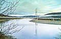 The Sami Bridge connects Utsjoki to Norway
 -
-
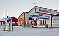
 Nuorgamin lomakeskus, the camping center of Nuorgam
.jpg)


References
[edit]- ^ a b "Area of Finnish Municipalities 1.1.2018" (PDF). National Land Survey of Finland. Retrieved 30 January 2018.
- ^ a b "Population increased most in Uusimaa in January to June 2025". Population structure. Statistics Finland. 2025-07-24. ISSN 1797-5395. Retrieved 2025-07-24.
- ^ a b "Number of foreign-language speakers exceeded 600,000 during 2024". Population structure. Statistics Finland. 2025-04-04. ISSN 1797-5395. Retrieved 2025-04-05.
- ^ "Population according to age (1-year) and sex by area and the regional division of each statistical reference year, 2003–2020". StatFin. Statistics Finland. Retrieved 2 May 2021.
- ^ a b "Luettelo kuntien ja seurakuntien tuloveroprosenteista vuonna 2023". Tax Administration of Finland. 14 November 2022. Retrieved 7 May 2023.
- ^ Puuronen, Vesa (2022-04-08), "Municipal Politics in the Sámi Homeland in Finland", The Sámi World (1 ed.), London: Routledge, pp. 348–363, doi:10.4324/9781003025511-24, ISBN 978-1-003-02551-1, retrieved 2025-03-25
- ^ Utsjoki. Fennica.pohjoiseen.fi. Retrieved 2023-06-2023.
- ^ "Suomen maakuntien ilmasto (The climate of the Finnish provinces)" (PDF). Finnish Meteorological Institute. Retrieved 2024-01-17.
- ^ Ruuhijärvi, Rauno (1960). "Über die regionale Einteilung der nordfinnischen Moore". Annales Botanici Societatis Zoologicae Botanicae Fennicae 'Vanamo' (in German). 31 (1): 360 pp.
- ^ Seppälä, Matti (1979). "Recent palsa studies in Finland". Acta Universitatis Ouluensis. Ser. A (82): 81–87.
- ^ King, Lorenz (1983). "High Mountain Permafrost in Scandinavia". Permafrost: Fourth International Conference, Proceedings: 612–617.
- ^ King, Lorenz (1982). "Qualitative und quantitative Erfassung von Permafrost in Tarfala (Schwedisch-Lappland) und Jotunheimen (Norwegen) mit Hilfe geoelektrischer Sondierungen". Zeitschrift für Geomorphologie (in German). Suppl.-Band (43): 139–160.
- ^ King, Lorenz; Seppälä, Matti (1987). "Permafrost thickness and distribution in Finnish Lapland - Results of geoelectrical soundings" (PDF). Polarforschung. 57 (3): 127–147. Retrieved 2021-02-25.
- ^ "FMI normals 1991-2020" (in Finnish). fmi.fi. Retrieved 11 April 2023.
- ^ "FMI open data". FMI. Retrieved 6 July 2025.
- ^ "FMI open data". FMI. Retrieved 21 March 2020.
External links
[edit]![]() Media related to Utsjoki at Wikimedia Commons
Media related to Utsjoki at Wikimedia Commons
![]() Utsjoki travel guide from Wikivoyage
Utsjoki travel guide from Wikivoyage
- Municipality of Utsjoki (in Finnish and Northern Sami)
- Explore Utsjoki (in Finnish, Northern Sami, and English)
- Hotel Luossajohka Utsjoki Archived 2007-02-01 at the Wayback Machine
Places adjacent to Utsjoki | ||||||||||||||||
|---|---|---|---|---|---|---|---|---|---|---|---|---|---|---|---|---|
| ||||||||||||||||
| Municipalities |  | |
|---|---|---|
| Former municipalities | ||
| International | |
|---|---|
| National | |
| Geographic | |
| Other | |
Utsjoki
View on GrokipediaUtsjoki is a municipality in Finnish Lapland, recognized as the country's northernmost administrative division, encompassing vast Arctic landscapes and serving as a primary homeland for the indigenous Sámi people, who constitute the majority of its residents.[1][2] Covering 5,372 square kilometers of largely untouched terrain, it supports a sparse population of approximately 1,178 individuals, many engaged in traditional reindeer herding, salmon fishing along the Teno River, and emerging year-round tourism.[3][4] Bordering Norway to the north and west, Utsjoki exemplifies the cross-border Sámi cultural continuum while preserving extensive natural areas vital for biodiversity and indigenous livelihoods.[1][5]
Geography
Location and Borders
Utsjoki is the northernmost municipality in Finland and the European Union, located in the Lapland region along the border with Norway.[6] It encompasses an area in northern Finnish Lapland, positioned above the Arctic Circle at coordinates approximately 69°55′ N, 27°02′ E.[7] The municipality shares its western and northern borders with Norway, primarily following the Teno (Finnish: Tenojoki; Norwegian: Tanaelva) River, which forms a natural boundary for much of the frontier.[8] To the south, Utsjoki adjoins the municipality of Inari, while its eastern extent remains within Finnish territory without direct contact with Russia.[8] This positioning facilitates cross-border interactions, with three official road crossing points into Norway: at Karigasniemi, the central Utsjoki village, and Nuorgam.[8] These crossings support local trade, tourism, and cultural exchanges, reflecting Utsjoki's strategic location in the Nordic Arctic.[3]Topography and Hydrology
Utsjoki's topography is characterized by smooth fell plateaus and undulating valleys, with large expanses below 300 meters above sea level and most summits under 500 meters in elevation.[9] The terrain appears flatter than in other Lapland regions, featuring glacial landforms such as the Utsjoki drumlin field extending northward and a kame topography with kettle holes in river valleys.[10][11][12] The Kevo Strict Nature Reserve within the municipality includes Finland's largest canyon, stretching 40 kilometers long and up to 80 meters deep, with associated waterfalls.[8] Hydrologically, Utsjoki lies within the Tana River basin, dominated by the Tenojoki (Teno River), which forms much of the border with Norway and supports significant salmon populations.[13][14] Tributaries including the Utsjoki River and Kidisjoki drain subalpine areas, contributing to the basin's flow regime influenced by seasonal snowmelt and precipitation.[15][16] The Utsjoki River valley exhibits deep incision into the fell plateau, with fluvioglacial deposits shaping local watercourses.[12]Climate and Permafrost
Utsjoki features a subarctic climate (Köppen Dfc), marked by prolonged cold winters, brief mild summers, and significant seasonal temperature contrasts driven by its high latitude and continental influences. Average annual temperatures hover around -2°C to 0°C, with extremes reaching -26°C in winter and occasionally exceeding 20°C in summer. Winters from November to April typically see daily highs below freezing and lows averaging -15°C to -20°C, accompanied by persistent snow cover lasting 200-220 days per year. Summers from June to August bring average highs of 12-15°C, though frost can occur even in July due to rapid diurnal cooling. Precipitation totals approximately 500-650 mm annually, predominantly as snow in winter (contributing 40-50% of yearly totals) and rain in summer, with relatively low evapotranspiration rates exacerbating moisture retention in soils.[17][18][19] Permafrost in Utsjoki is sporadic and discontinuous, confined mainly to specialized landforms rather than widespread ground coverage, reflecting the region's marginal thermal regime where mean annual air temperatures approach but rarely sustain the -3°C threshold for continuous permafrost. It predominantly manifests in palsa mires—elevated peat plateaus with cores of ice-rich permafrost formed through cryogenic processes in waterlogged, poorly drained organic soils. These features, common in northern Lapland's mires, occur at low elevations down to approximately 50 meters above sea level in Utsjoki, contrasting with more elevational dependence in southern Fennoscandia. Palsa permafrost depths typically range from 1-3 meters, sustained by insulating peat layers that minimize summer thaw, though active layer thaw depths vary from 0.5-1.5 meters annually.[20][21][22] The limited extent of permafrost stems from relatively high precipitation (exceeding 400 mm annually in many areas) and moderate winter snow insulation, which prevent the ground from reaching sufficiently low temperatures for broad aggradation, unlike in drier Arctic tundra. Isolated occurrences also appear on north-facing fjell slopes and blockfields in higher terrains like the Kevo region, where wind redistribution of snow exposes mineral soils to extreme cold. Ongoing climatic warming has accelerated palsa degradation since the mid-20th century, with observations of thermokarst ponding and mire collapse in Utsjoki's palsa fields, though remnant patches persist in sheltered microtopographies. This patchwork distribution influences local hydrology, restricting drainage in mires and supporting specialized subarctic ecosystems, but poses challenges for infrastructure stability where thaw subsidence occurs.[22][23]Vegetation and Flora
The vegetation in Utsjoki transitions from mountain birch (Betula pubescens subsp. czerepanovii) woodlands in the lush Teno River valley to treeless alpine tundra on the surrounding fells and highlands, reflecting the subarctic climate with short growing seasons and nutrient-poor soils.[24] These birch forests, often dense in valleys but sparse and low-growing at higher elevations, form the primary arboreal cover, with understories dominated by dwarf shrubs, mosses, lichens, and graminoids adapted to permafrost-influenced substrates.[25] Coniferous trees like Scots pine (Pinus sylvestris) are absent or extremely rare, confined to isolated low-altitude sites near the southern municipal boundary, as the treeline elevates northward into birch-only zones.[26] Flora in the fell tundra includes characteristic arctic-alpine species such as dwarf willow (Salix herbacea), Lapland diapensia (Diapensia lapponica), and blue heath (Phyllodoce caerulea), which thrive in wind-exposed, rocky terrains of wilderness areas like Paistunturi and Kaldoaivi.[27] Common field-layer plants in mesotopographic gradients encompass sedges like Carex bigelowii, crowberry (Empetrum nigrum), sheep's-fescue (Festuca ovina), mat-forming Harrimanella (Harrimanella hypnoides), alpine azalea (Kalmia procumbens), and matgrass (Nardus stricta).[25] Rare vascular plants, including Lapland rhododendron (Rhododendron lapponicum), occur sporadically on select fells, highlighting localized endemism amid broader tundra assemblages.[28] Autumnal foliage displays feature vibrant colors from rowan (Sorbus aucuparia) and European aspen (Populus tremula), contrasting the evergreen lichens and mosses that dominate year-round.[29]History
Indigenous Sami Settlement and Pre-Modern Era
The indigenous Sámi people, descendants of post-Ice Age populations, have occupied the Utsjoki region in northern Fennoscandia for approximately 10,000 years, initially through hunting, fishing, and gathering economies adapted to the subarctic environment.[30] Archaeological evidence from sacred offering sites, such as Sieiddakeädgi near the Utsjoki River, confirms ritual and subsistence use dating to at least the medieval period, with reindeer bones radiocarbon-dated between 1165 and 1660 CE, alongside artifacts like coins and glass from later interactions.[31] These sites underscore pre-Christian Sámi spiritual practices, where offerings of reindeer, fish, and metal objects sought to ensure successful hunts and resource abundance.[31] Sámi social organization in Utsjoki centered on siidas—kin-based cooperative units that coordinated seasonal migrations, land use, and resource management across broader northern territories, including river valleys vital for fishing salmon in the Utsjoki and Teno rivers.[30] The pre-modern economy emphasized wild reindeer hunting supplemented by gathering and early reindeer husbandry, which emerged gradually over millennia; zooarchaeological data from northern Finnish offering sites (c. 1200–1700 CE) reveal selective sacrifices of large male reindeer with antlers, indicating human influence on breeding and mobility patterns consistent with proto-domestication.[32] Stable isotope analyses further support dietary shifts toward managed herds, distinguishing these practices from purely wild exploitation.[32] By the early modern era, prior to intensified Finnish settlement, Utsjoki's Pappila area functioned as a seasonal market and ecclesiastical hub from around 1640, with a church established in 1701; faunal assemblages from 17th–18th-century contexts show reindeer comprising over 90% of identifiable bones (e.g., 1,927 specimens from one structure), reflecting sustained herding and hunting alongside limited domestic cattle, sheep, and fish trade like cod and salmonids.[33] These patterns highlight economic resilience through diversified livelihoods, including fur and dried fish exchanges, while maintaining cultural continuity amid emerging Nordic state influences.[33]Establishment and 19th-20th Century Developments
The establishment of Utsjoki as a distinct administrative and settlement center occurred in the mid-19th century with the construction of its stone church between 1850 and 1853, commissioned by Tsar Nicholas I of Russia during Finland's time as a Grand Duchy under Russian rule.[34] [35] Designed by architect Ernst Lohrmann, the church utilized local fell stones and bricks from nearby Sirma, serving as a focal point for religious and communal activities in the sparsely populated region.[36] This development facilitated the growth of the church village (kirkonkylä), where existing log cabins (kirkkotuvat) from the 18th century were supplemented by additional 19th-century structures to house traveling Sami families for church services, markets, and legal proceedings.[37] [1] Utsjoki was formally separated as an independent municipality in 1876, transitioning from its prior subordination to broader units such as the Tornio Lapland administrative area established in the 16th century and later the Tornio chaplaincy from 1602.[38] [39] At this time, the population remained modest, with estimates indicating fewer than 500 residents by the end of the 19th century, reflecting slow growth amid harsh Arctic conditions and reliance on subsistence activities like reindeer herding and fishing along the Tenojoki River.[40] [38] Throughout the early 20th century, Utsjoki's developments were characterized by gradual infrastructural improvements and persistence of traditional Sami livelihoods, with some families adopting more nomadic reindeer herding patterns that had emerged in the prior century.[41] The kirkkotuvat continued in use until the 1930s, underscoring the enduring role of the church village as a seasonal hub.[1] Transport links advanced modestly during the interwar period, with road construction progressing in the 1920s and 1930s under national initiatives, though the area retained its primary-sector economy focused on herding and riverine resources until mid-century shifts. [42]Post-WWII Modernization and Recent Events
Following the Lapland War, Utsjoki sustained minimal physical damage, with only approximately 30 houses destroyed owing to limited German military access in the area.[43] The municipality's roughly 850 residents were evacuated on September 7, 1944, to Ostrobothnia, an experience that facilitated exposure to Finnish cultural norms, including adoption of Finnish clothing and language, hastening transcultural shifts.[43] Reconstruction from 1945 to 1952 emphasized standardized housing and infrastructural integration into Finland's national framework, including new roads that linked Utsjoki to southern regions and eroded its prior isolation.[43] The primary access road reached completion in the 1960s, transforming logistics; beforehand, mail transport from Kaamanen—100 km south—required three days via bicycle, supplemented by boat crossings of lakes.[38] These developments paralleled a broader post-war modernization in Lapland, shifting from rudimentary networks to enhanced connectivity that supported economic diversification.[38] Economically, self-sufficient livelihoods gave way to a monetary system, with state encouragement of agriculture and cattle rearing supplementing reindeer husbandry and fishing; reindeer numbers fell 60% between 1945 and 1948 amid wartime disruptions and policy pressures.[43] Professional fishing waned in the 1950s following Lake Inari's regulation, which altered traditional practices.[43] Improved roads spurred service-sector growth, particularly tourism, as accessibility drew visitors to the Teno River valley and border landscapes.[38] Socially, Finnish settlers and institutions accelerated Finnicization, culminating in the municipal council's adoption of Finnish as its working language in the 1950s.[43] Counterbalancing this, the formation of Samii Litto in spring 1945 initiated organized Sami advocacy, while education reforms after 1947—intended for assimilation—nonetheless nurtured a politically engaged Sami cohort.[43] Population grew modestly post-war, from 980 in 1950 (including nearly 300 Finns) to 1,209 by 1960, reflecting influxes that diversified the ethnic composition to parity between Sami and Finns by the 2020s.[38] In recent years, Utsjoki has leveraged its northern extremity for cultural and ecotourism, hosting events like the 2025 Iđitbeali rap festival emphasizing Sami music under the midnight sun.[44] Scientific findings, such as the 2025 identification of a 1,647-year-old juniper shrub in the municipality—dating to 260 CE and ceasing growth in 1906—underscore ongoing research into Arctic longevity amid climate pressures.[45] Population stabilized near 1,180 by 2023, with tourism offsetting challenges in traditional herding.[38]Demographics
Population Trends
The population of Utsjoki grew modestly through the early 20th century, driven by expansions in reindeer husbandry and settlement along the Tana River valley, but has since undergone a sustained decline due to net out-migration, low fertility rates, and limited economic diversification in this remote Arctic location.[38] Historical estimates place the population below 500 at the end of the 19th century, reflecting sparse indigenous Sami communities prior to formal municipal establishment in 1876.[40] By 1950, it had risen to 980 residents, increasing to 1,209 by 1960 amid post-war stabilization and minor influxes from adjacent regions.[38] From 1975 to 2015, the population contracted by 21.1%, falling to approximately 1,052 amid broader rural depopulation trends in Finnish Lapland, where youth emigration to urban centers for education and employment outpaces natural growth.[46] As of 2023, the figure stood at 1,137, with an annual decline rate of -1.7% between 2021 and 2023, characterized by a skewed age structure favoring those over 65 and negative net migration balances reported annually by Statistics Finland.[47][48] Projections from Statistics Finland indicate further reductions, potentially dropping below 1,000 by 2040, exacerbated by an aging populace and reliance on seasonal livelihoods like herding and tourism that fail to retain permanent residents.[49] This mirrors causal patterns in northern peripheries, where infrastructural isolation and climatic constraints amplify demographic pressures without countervailing industrial or service-sector booms.[50]Ethnic and Linguistic Composition
Utsjoki possesses a Sami ethnic majority, rendering it the sole municipality in Finland where the indigenous Sámi people outnumber other groups. This composition reflects the region's historical role as a core area of Sámi settlement, with ethnic Sámi comprising roughly 50% or more of residents, while the remainder are primarily ethnic Finns who have settled in the area since the 19th century.[1][51] Finland does not conduct official ethnic censuses, leading estimates to rely on self-identification, language use, and cultural affiliation; sources consistently affirm the Sámi predominance in Utsjoki despite assimilation pressures and intermarriage.[52] Linguistically, the municipality recognizes both Finnish and Northern Sámi as official languages, with the latter spoken as a mother tongue by approximately 40-46% of the population, the highest proportion among Finnish municipalities.[8] Finnish remains the dominant language overall, used by the majority, though bilingualism is common among Sámi residents. Small numbers speak other languages, including Norwegian due to proximity to the border, but these constitute less than 5% of inhabitants.[4] This linguistic profile underscores Utsjoki's status within Finland's Sámi Domicile Area, where efforts to preserve Northern Sámi include municipal services and education in the language.[53]Economy and Livelihoods
Reindeer Husbandry
Reindeer husbandry forms a cornerstone of traditional livelihoods in Utsjoki, the northernmost municipality in Finland, where it supports the predominantly Sámi population and integrates with modern practices. The area falls within the Sámi homeland, designated as a special zone for reindeer herding under Finnish law, encompassing free-range grazing across vast fell and forest landscapes. Herders manage semi-nomadic herds that migrate seasonally, relying on natural lichen pastures while supplementing with local winter fodder to sustain the cycle.[54][55] Utsjoki hosts two primary herding cooperatives: Kaldoaivi, operating in the northernmost fells bordering Norway, and Paistunturi, focused on adjacent terrains, both part of the Utsjoki marking district. These cooperatives oversee round-ups using drones for efficient, low-impact calf marking and herd monitoring, minimizing stress on animals and habitats. Reindeer populations exceed 10,000 in the municipality—outnumbering the roughly 1,000 human residents by a factor of ten—reflecting intensive management within a total Finnish reindeer count regulated annually by the Ministry of Agriculture and Forestry.[56][57][1][58] Economically, herding generates income primarily through meat sales, with secondary products like hides and antlers contributing to handicrafts and tourism experiences such as feeding tours and sleigh rides. Nationally, reindeer husbandry yields around 60 million euros annually, with meat comprising the bulk; in Utsjoki, it underpins local Sami families' revenues, often augmented by herding-related tourism that promotes cultural continuity. Subsidies cover under 20% of operations, emphasizing self-reliance amid fluctuating market prices for calves and meat.[59][60][55] Challenges include over 75% depletion of natural lichen pastures in Sámi-dominated areas like Utsjoki due to forestry, climate-driven vegetation shifts, and snow variability, prompting adaptations like supplementary feeding and forest protection initiatives funded by the Ministry of the Environment. Herders emphasize resonance strategies, drawing on traditional knowledge to navigate extreme weather, while public guidelines urge minimizing disturbances during calving and rutting seasons to preserve herd health. Cultural transmission persists through institutions like the Skalluvaara round-up school, ensuring skills in herding and predator management.[61][62][63][54]Tourism and Fishing
Tourism in Utsjoki centers primarily on recreational salmon fishing in the Teno River during summer, drawing anglers from Finland, Norway, and beyond due to the river's status as one of Europe's largest Atlantic salmon producers.[64][65] The municipality's remote location and pristine wilderness also support hiking and cycling on hundreds of kilometers of trails, though these activities remain secondary to fishing.[66] Seasonal patterns dominate, with peak visitation in summer; for instance, Utsjoki recorded 23,700 registered overnight stays between May and October 2020, bolstered by domestic travel amid international restrictions.[67] Fishing targets Atlantic salmon (Salmo salar), with the Teno system yielding significant catches historically—46% via traditional local methods like gillnets and 29% by rod fishing from Finnish and Norwegian participants, per system-wide statistics. Annual salmon catches in the broader Teno vary, but conservation measures, including quotas and occasional bans, have been imposed to protect declining stocks; for example, a fishing ban prompted tourism diversification into sustainable alternatives like cycling infrastructure.[68][69] Licenses are mandatory, and effort data from fishers and permits inform management under joint Finnish-Norwegian agreements.[70] To counter seasonality, Utsjoki promotes year-round development, including winter tourism for northern lights viewing and Sami cultural experiences, aiming to boost local tax revenues in the northernmost municipality.[71] Facilities like Holiday Village Valle accommodated under 6,000 visitors annually pre-2020, with international guests favoring winter stays.[67] Emphasis on low-carbon practices underscores sustainability efforts amid environmental pressures from rising Lapland visitation, which increased 160% over 30 years region-wide.[72][73]
Other Economic Activities and Challenges
Border trade with Norway represents a primary economic activity beyond traditional livelihoods, with over 75% of the 125 local companies' trade turnover—totaling 36 million euros—stemming from cross-border commerce.[3] This includes retail and services catering to Norwegian customers, facilitated by the municipality's position along the Finland-Norway frontier. Primary production, encompassing subsistence farming and small-scale agriculture adapted to Arctic conditions, supplements income through activities like berry harvesting and limited crop cultivation, though commercial viability remains constrained by the harsh climate and short growing season.[3] [24] Utsjoki features no large-scale industry, such as mining or energy production, limiting employment to modest service-oriented enterprises like repair shops and local retail that support residents and transient trade.[24] Economic challenges include abrupt structural shifts, addressed by a 300,000 euro government grant in December 2021 to mitigate declining viability in remote areas.[74] Population stagnation at around 1,178 inhabitants contributes to labor shortages and outmigration, mirroring broader trends in northern Finland where younger demographics seek opportunities elsewhere, hindering business expansion and necessitating additional land for housing and operations.[3] [75] External disruptions, including COVID-19-induced border closures, have curtailed trade flows, exposing overreliance on Norway and underscoring the need for diversification amid regional disparities in employment and growth.[76] [77]Culture and Society
Sami Traditions and Language
Northern Sami (davvisámegiella), the most widely spoken Sami language, predominates in Utsjoki, where it functions as a core area for the dialect alongside Finnish.[78] Sami languages, including Northern Sami, have held official status in Utsjoki since 1992 under Finnish law, entitling speakers to public services in their language and requiring municipal administration to provide bilingual capabilities where demand exists.[79] This status extends to education, where Northern Sami-medium instruction is available, supported by the Sámi Parliament of Finland's efforts to counteract endangerment through language revitalization programs.[80] Ethnically Sami residents form a majority in Utsjoki, sustaining daily use of Northern Sami in homes, herding groups (siidat), and community interactions, though intergenerational transmission faces challenges from urbanization and Finnish dominance in formal settings.[52] Sami traditions in Utsjoki emphasize cultural continuity tied to the Arctic environment, including joik (luohti), an unaccompanied vocal form improvising melodies to evoke people, animals, or landscapes without lyrics, performed at gatherings to reinforce social bonds and identity.[81] Duodji, the traditional handicraft system, involves crafting functional and symbolic items from reindeer antler, bone, horn, and hides—such as knives (unna niiba), cups (gáhtin), and jewelry—using techniques passed down orally, with modern practitioners adapting them for cultural preservation amid commercialization pressures.[82] The gákti, a colorful, regionally varied tunic with apron-like elements, is donned for festivals, church events, and rites of passage, symbolizing clan affiliation through patterns and materials; in Utsjoki, its use persists visibly at local celebrations, distinguishing it from everyday attire.[1] Historically rooted in animistic beliefs with noaidi shamans mediating human-nature relations via drums and chants, these traditions have integrated with Lutheran Christianity since the 17th century, evident in Utsjoki's church village (kirkkoniemi) where Sami rituals blend with services.[81] The Sámi Parliament coordinates preservation initiatives, including cultural education and opposition to assimilation-era policies like 19th-century Finnishization campaigns that suppressed Sami practices, fostering resilience through documentation and youth programs despite ongoing debates over land rights impacting traditional knowledge transmission.[80][52]Community Events and Education
Utsjoki hosts community events centered on Sámi heritage, including the annual Ohcejohka Šearrá cultural festival on July 5, which features performances by prominent Sámi artists and cultural activities at the Onnela ridge.[83] Sámi National Day, observed on February 6, brings residents together for gatherings involving traditional dress, joik singing, storytelling, and demonstrations of indigenous practices, emphasizing cultural continuity in the northernmost Finnish municipality.[84] These events foster local identity amid the sparse population of approximately 1,200, often incorporating elements of reindeer husbandry and nature-based traditions.[85] The education system in Utsjoki aligns with Finland's national framework of free, compulsory basic education but emphasizes bilingualism due to the Sámi majority. The municipality maintains three comprehensive schools offering instruction in both Finnish and Northern Sámi for grades 0–9, with facilities in Karigasniemi and Utsjokisuun providing full primary and lower secondary curricula.[86] Early childhood education includes Sámi language nests (pohjoissaamen kielipesät) to support linguistic immersion from a young age.[87] Sámi-language teaching in elementary schools originated in the early 1970s here, marking Utsjoki as a pioneer in indigenous-language instruction within Finland's system.[88] Upper secondary options incorporate distance learning for Sámi languages to enhance access in remote areas, complementing on-site bilingual programs.[89]Administration and Infrastructure
Local Governance
Utsjoki operates under the standard framework of Finnish municipal governance, as outlined in the Municipal Act (Kuntalaki 410/2015), with the municipal council (kunnanvaltuusto) serving as the highest decision-making body. The council consists of 15 members elected by universal suffrage every four years, responsible for approving the municipal strategy, budget, and major policies.[90][91] The council elects a municipal board (kunnanhallitus) of seven members, including a chairperson and vice-chairperson, each with personal deputies, to handle executive functions such as operational management, financial oversight, and legality of decisions. The board delegates day-to-day administration to the mayor (kunnanjohtaja), who leads municipal operations, prepares agendas, and implements council directives.[90] Päivi Kontio has served as mayor since her appointment by the council on November 29, 2023, with a 12-3 vote, succeeding Taina Pieski; Kontio, previously the municipality's welfare director, focuses on navigating fiscal challenges and regional cooperation.[92][93] Utsjoki participates in the Federation of Northern Lapland municipalities (Pohjois-Lapin kunnat), a cooperative body with Inari and Sodankylä for lobbying and joint services, reflecting its remote location and shared Arctic interests.[94]Transportation and Public Services
Utsjoki's transportation infrastructure centers on the European route E75, which traverses the municipality north-south and facilitates cross-border travel to Norway via the Sami Bridge over the Tana River. This cable-stayed bridge, spanning approximately 300 meters, links Utsjoki directly to Norwegian territory and serves as a key border crossing point open to human traffic while restricting reindeer movement.[95][96] Access to Utsjoki primarily occurs by private vehicle or limited coach services, with daily buses connecting from Ivalo Airport, roughly 200 kilometers south, via operators like Matkahuolto.[97][98] No extensive local public transport exists, necessitating personal cars or taxis for intra-municipal travel, particularly given the sparse road network and remote terrain.[99] The nearest airports are Ivalo in Finland and Kirkenes in Norway, both offering connections to Helsinki and beyond, with driving times of about 2.5 hours from Ivalo.[1] Public services in Utsjoki are managed under the Lapland wellbeing services county, which oversees health, social welfare, and rescue operations. The local health center, Utsjoen Terveyskeskus, provides primary care including prenatal, child health, contraception, school health, and chronic disease management such as diabetes.[100][101] Residents access emergency services through regional facilities in Rovaniemi or Inari, supported by a 24/7 medical helpline.[102][103] Education occurs via municipal schools emphasizing Northern Sami language instruction, with programs dating to the 1970s for elementary levels and early childhood Sami education.[88] Utilities, including electricity distribution, water supply, and district heating, are handled by regional providers like Inergia Oy, ensuring basic infrastructure despite the area's isolation.[104]Environment and Land Use Conflicts
Protected Areas and Biodiversity
Utsjoki hosts several key protected areas managed primarily by Metsähallitus, Finland's state-owned forest enterprise responsible for conservation. The Kevo Strict Nature Reserve, established on December 17, 1956, spans 712 square kilometers and preserves pristine subarctic landscapes including a 40-kilometer canyon formed over 70 million years ago, open fells, mountain birch forests, tundra mires, and geological features like eskers.[105] Access is restricted to marked trails for hiking, with permits required for activities beyond day visits to minimize human impact on fragile ecosystems.[106] The municipality encompasses large wilderness areas designated under Finland's Wilderness Act of 1991, which balances conservation with traditional livelihoods such as reindeer herding. Kaldoaivi Wilderness Area covers 2,924 square kilometers, featuring vast mires, rivers, and fells that support migratory bird populations and ungulates.[8] Paistunturi Wilderness Area adjoins it to the south, providing contiguous protected habitat across the Utsjoki valley, while portions of Muotkatunturi Wilderness Area extend into the region.[24] These areas, totaling over 4,000 square kilometers within Utsjoki boundaries, allow free movement for herders and hikers but prohibit motorized vehicles and commercial forestry to maintain ecological integrity.[107] Approximately 90 percent of Utsjoki's land area falls under national protection statutes, including nine Natura 2000 sites designated under the EU Habitats Directive for safeguarding habitats like herb-rich meadows (e.g., Kirkkotupien niitty) and riparian zones along the Teno River.[108][109] Utsjoki's biodiversity reflects its position in the transition zone between boreal forests and Arctic tundra, with ecosystems ranging from lowland Scots pine stands to high-elevation alpine heaths and palsa mires.[110] Flora includes resilient species such as mountain birches (Betula pubescens subsp. czerepanovii) and the longest-lived known juniper (Juniperus communis), with a specimen dated to 378 CE (1,647 years old) via radiocarbon analysis of its roots, demonstrating adaptive longevity in nutrient-poor soils.[45] Fauna features the endangered Arctic fox (Vulpes lagopus), which dens in Kevo's rugged terrain, alongside wolverines, golden eagles, and migratory waterfowl; the Teno River supports Atlantic salmon (Salmo salar) runs critical for local food webs.[106] Scientific monitoring at the nearby Kevo Subarctic Research Institute reveals vulnerability to climate shifts, with 2024 assessments documenting dieback in mountain birch forests within Kaldoaivi and Paistunturi—evidenced by reduced canopy cover and increased pest outbreaks—despite protective status, underscoring limits of static reserves in dynamic environments.[111][110] Sami herders' traditional knowledge emphasizes interconnected biodiversity, viewing lichen-rich old-growth forests as essential for reindeer forage amid declining winter pastures.[112] Conservation efforts prioritize habitat connectivity to buffer against fragmentation from warming temperatures and potential tourism expansion.[113]Development Pressures and Conservation Debates
In Utsjoki, mining exploration constitutes a primary development pressure, fueled by geological surveys identifying potential deposits of metals and minerals amid Finland's push for critical raw materials to support industrial and green transitions. During 2014–2015, Sami residents in Ohcejohka launched an organized resistance movement against prospecting by multinational firms, employing counter-mapping techniques to contest state and corporate representations of the land as economically exploitable resources rather than a holistic, culturally embedded landscape integral to ancestral practices and social relations.[114] This opposition stems from anticipated adverse effects on reindeer herding, Utsjoki's dominant traditional livelihood, including disruption of seasonal migration corridors, habitat fragmentation, and risks of water contamination from tailings or spills, which could impair grazing lands and downstream ecosystems like the Teno River watershed.[114][115][116] Local reindeer herders and communities have highlighted incommensurabilities between extractive paradigms and Sami ontologies, where land use conflicts exacerbate vulnerabilities in an already marginal economy reliant on herding for cultural continuity and income.[115] Conservation responses emphasize safeguarding biodiversity and traditional uses through measures such as reindeer owners' applications for state funding to protect old-growth forests in northern Lapland, initiated around 2021, which preserve carbon sinks and lichen-rich winter pastures vital for herd health.[62] These efforts align with broader Finnish commitments under EU habitats directives and national biodiversity strategies, prioritizing low-impact land management over intensive development in sensitive Arctic terrains.[117] Debates intensify over balancing sparse economic opportunities—such as potential mining jobs in a municipality of under 1,200 residents—with irreversible ecological and cultural costs, including diminished reindeer viability documented in regional studies of extractive impacts.[118] Proposed wind energy infrastructure in Finnish Lapland adds to these tensions, as herders report turbine-induced avoidance in reindeer, fragmenting pastures and challenging legislative protections for herding rights amid limited participatory mechanisms in permitting processes.[119] Proponents cite national energy security needs, while critics, including Sami advocates, demand enhanced impact assessments incorporating indigenous knowledge to avert precedents seen in cross-border conflicts.[120]Notable Individuals
Inger-Mari Aikio-Arianaick (born 1961) is a Finnish Sámi poet who writes in Northern Sámi and has published lyrical collections and children's books exploring Sámi themes.[121][122] She was born in Utsjoki and has worked in Sámi radio.[121] Pigga Keskitalo (born 1972) is a professor of education at the University of Lapland, specializing in Arctic perspectives, Sámi education, and linguistically conscious teaching methods.[123][124] Originating from Utsjoki, she has served as a member of the Sámi Parliament of Finland and researches indigenous enculturation processes.[123] Irja Seurujärvi-Kari (born November 21, 1947) is a Sámi academic and former politician who has lectured in Sámi studies at the University of Helsinki and contributed to indigenous rights advocacy.[125] Born in Utsjoki, she earned a PhD in Finno-Ugric languages in 2012 and headed the Utsjoki upper secondary school for Sámi students from 1978 to 1985.[125][126] Sverre Porsanger (born 1963) is a Norwegian-Sámi actor known for roles in films depicting Sámi life, including Pathfinder (1987) and The Kautokeino Rebellion (2008).[127][128] He was born in Utsjoki and has appeared in productions such as Ante (1976) and the TV series Lilyhammer.[127]References
- https://en.wikivoyage.org/wiki/Utsjoki