Hubbry Logo
Via RegiaVia RegiaMain
Open search
Via Regia
Community hub
Via Regia
logo
8 pages, 0 posts
0 subscribers
Be the first to start a discussion here.
Via Regia
Via Regia
from Wikipedia
Via Regia
Royal Highway
Route information
Length4,500 km (2,800 mi)
Time periodAntiquity, medieval
Major junctions
FromMoscow[citation needed]
ToSantiago de Compostela
Location
Countries
Highway system
Via Regia and Via Imperii
Via Regia between Fulda and Neuhof in Hesse, Germany

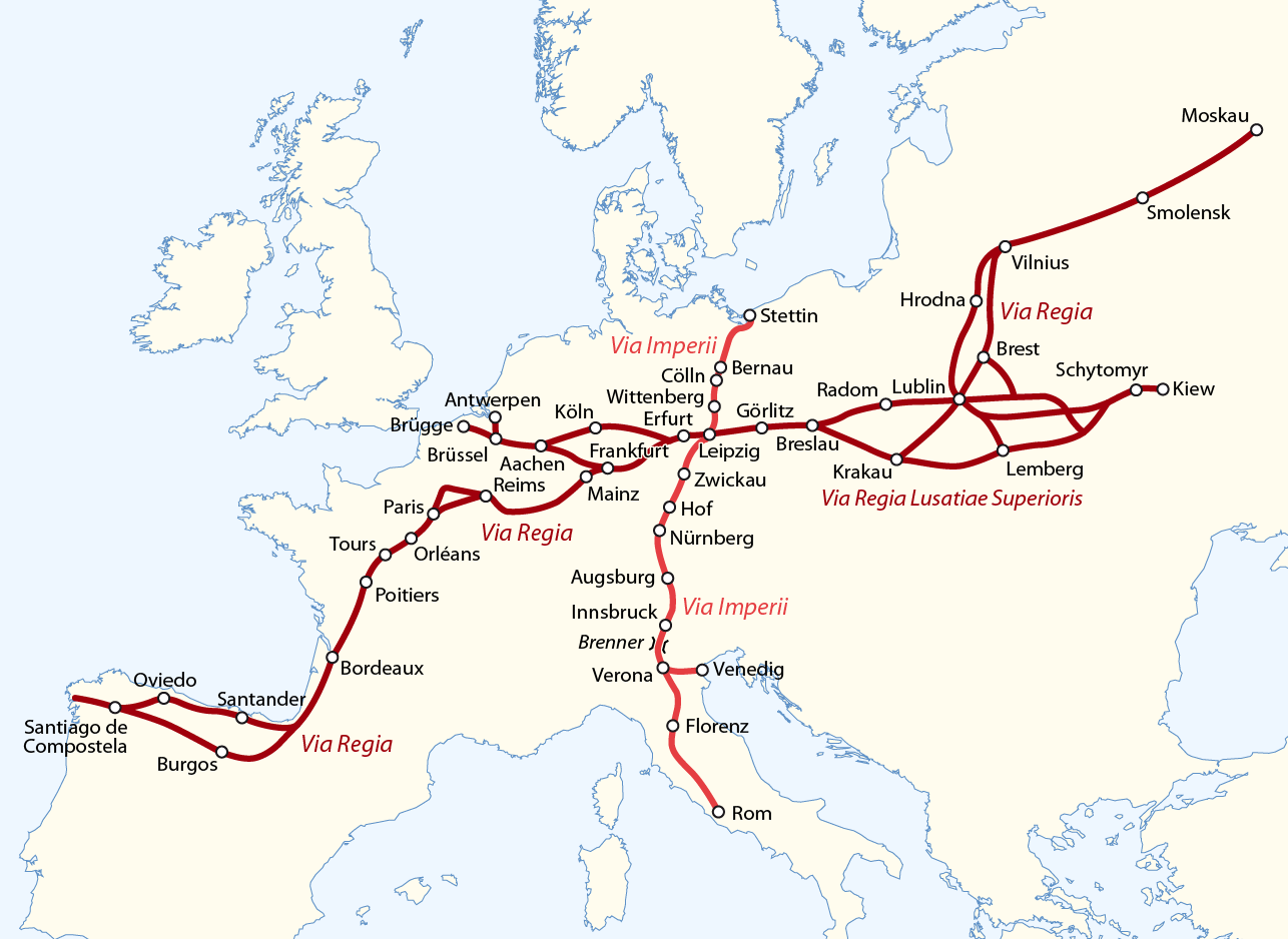
The Via Regia (Royal Highway) is a European Cultural Route following the route of the historic road of the Middle Ages. There were many such viae regiae associated with the king in the medieval Holy Roman Empire.

History

[edit]

Origins

[edit]

The Via Regia ran west–east through the centre of the Holy Roman Empire, from the Rhine at Mainz-Kastel (Elisabethenstraße) to Frankfurt am Main, trade city and site of the election of the King of the Romans, continuing along Hanau, the Kaiserpfalz at Gelnhausen, the towns of Steinau an der Straße, Neuhof, Fulda and Eisenach to Erfurt, a centre of woad production. It ran further eastwards to Eckartsberga, crossing the Saale river between Bad Kösen and Naumburg and reached Leipzig, another trade city. The eastern part continued through Upper Lusatia (Via Regia Lusatiae Superioris) along Großenhain, Königsbrück, Kamenz, Bautzen and Görlitz to Wrocław in Silesia with further connection to Kraków in Poland.

Medieval period

[edit]

The road was first mentioned as strata regia in a document issued by Margrave Henry III of Meissen in 1252, while its origins date back to the 8th and 9th centuries. After the downfall of the Imperial power in Central Germany in favour of the Saxon House of Wettin following the 1307 Battle of Lucka, the road lost its royal status and from the 14th century this route could no longer really be spoken of as a "Via Regia".

Elisabethenstraße at Mainz-Kastel

Nevertheless, the important section of the road between Frankfurt and Leipzig continued to exist under the name Hohe Straße ("High Road"). It remained under sovereign control of e.g. the Bohemian Crown in Upper Lusatia, the Saxon electors, the Abbey of Fulda, and the Archbishopric of Mainz and was chartered through tolling. Also the branch-off from Frankfurt am Main to Cologne via Wetzlar was called Hohe Straße.

The road had a large economic significance for interregional trade and bartering. From the west came Flemish blankets, from the east wood, pelts, wax and honey, and the middle section controlled the German indigo (Isatis tinctoria) of the Thuringian Basin as well as the mining products of the Saxon Ore Mountains. The High Road also provided the direct route between the largest German trade fairs of Frankfurt and Leipzig.

Pilgrims who took part in the Aachen Cathedral shrine pilgrimage used the road in large numbers. Thereto they turned off the trunk road at Eisenach along the "Long Hesse" road to Marburg and Cologne. Testimonies of the pilgrimage to Santiago de Compostela are known from Großenhain, Leipzig, Erfurt, Gotha, Vacha, Fulda, Frankfurt am Main and Mainz.

The road was repeatedly used by armies. Some large battles came to pass in its catchment area (e.g. Breitenfeld 1631, Lützen 1632, Rossbach 1757, Hochkirch 1758, and Jena-Auerstedt 1806 as well as the Battles of Bautzen, Lützen (Großgörschen) and Leipzig in 1813).

19th century to present day

[edit]

After the final defeat of Napoleon, the significance of the road declined, since, as a result of the reduction of the Kingdom of Saxony by large parts of its Lusatian territories at the Congress of Vienna, the toll on behalf of Leipzig was no longer continued.[citation needed]

Parts of the historic Via Regia route are today marked by major national roads: between Eisenach and Erfurt by the Bundesstraße 7 (B7); between Eckartsberga and Leipzig by the B87; and between Leipzig and Görlitz by the Bundesstraße 6 (B6) and eastwards to Kraków by the Polish national road 94. In Hanau the Birkenhainer Strasse branches off the Via Regia crossing the Spessart mountain range towards Gemünden am Main in Franconia, also as a high road.[citation needed]

Tourism

[edit]

The Council of Europe awarded the Via Regia the title of Major Cultural Route of the "Council of Europe” in 2005. According to the Council of Europe, it "is the name of the oldest and longest road link between the East and the West of Europe. The route has existed for more than 2,000 years and connects 8 European countries through a length of 4,500 km."[1]

See also

[edit]

References

[edit]

Literature

[edit]
  • Ludwig Steinfeld: Chronik einer Straße. Die alte Straße von Frankfurt nach Leipzig; Geschichte, Ereignisse, Reiseberichte. Geiger-Verlag, Horb am Neckar 1994, ISBN 3-89264-360-1
[edit]
Revisions and contributorsEdit on WikipediaRead on Wikipedia
from Grokipedia
The Via Regia is the oldest and longest road connecting Eastern and , extending approximately 4,500 kilometers from Galicia in to Galicia in and serving as a vital corridor for , migration, , and cultural exchange over more than 2,000 years. Certified as a Cultural Route of the in 2005, it embodies the continent's shared heritage and promotes values of unity and diversity through its historical and modern significance. Historically, the route originated in prehistoric times, with archaeological evidence indicating its use by migrating tribes, and it developed into a major medieval pathway known as the "Royal Road" due to privileges granted by rulers for safe passage. During the , it facilitated extensive economic and cultural interactions, linking key centers such as , , , , and , while enabling the flow of merchants, pilgrims, and ideas across regions from the to Eastern principalities. Its zenith in the medieval period underscored its role in shaping Europe's interconnected landscape, with offshoots and protections under imperial law enhancing its status as a linear east-west axis. In the , the Via Regia aligns with European Development Corridor III, a transport network spanning ten countries including , , , , , , , , and others, while engaging 47 regions in heritage initiatives. It now emphasizes sustainable "slow travel" experiences, such as walking pilgrimages and cultural events, to foster , , and preservation of both tangible sites—like historic towns and architecture—and intangible traditions of European identity. Headquartered in , , the route's international association drives projects that highlight its enduring symbol of transcontinental cooperation and deceleration in a fast-paced world.

Route Description

Overview and Extent

The Via Regia, often called the "Royal Road," is recognized as the oldest east-west road link in , with roots tracing back to pre-Roman and Roman paths used by migrating tribes since the , though it was formalized as a major trade and pilgrimage route during the under royal protection in the . This ancient corridor facilitated connectivity across the continent long before the development of modern infrastructure, serving as a vital artery for movement and exchange. Spanning approximately 4,500 kilometers, the Via Regia connects Western Europe, beginning near Santiago de Compostela in Galicia, Spain—a key pilgrimage endpoint—to Eastern Europe, extending through various segments to reach Ukraine and, in some historical extensions, as far as Moscow in Russia. Its path integrates ancient tracks, medieval highways, and later alignments, forming a continuous axis that predates contemporary European transport networks like the Pan-European Corridors. The route traverses eight countries—Spain, France, Belgium, Germany, Poland, Lithuania, Belarus, and Ukraine—with historical extensions to Russia, depending on specific alignments and modern interpretations. Designated a Major Cultural Route of the in 2005, it underscores trans-European historical ties and continues to influence regional development through initiatives like European Development Corridor III.

Path and Key Segments

The Via Regia traces an ancient east-west corridor across , adapting to natural geography such as river valleys and mountain passes while linking diverse regions. Its path generally follows lowlands north of the central European mountain belt and south of post-Ice Age glacial zones, facilitating relatively straightforward navigation for travelers since prehistoric times. The route's trajectory incorporates variations to accommodate terrain, including strategic river crossings at major waterways like the , , and , which served as natural gateways between segments. The western segment originates at in northwestern , proceeding eastward through northern along pilgrimage paths before entering . It navigates the via accessible passes such as or , then continues through central and into , ultimately connecting to the region in western near the River crossing. This portion emphasizes lowland traversal and avoids high alpine barriers, reflecting its role in early medieval connectivity. In the central segment, the route traverses from on the eastward to near the Polish border, encompassing the Hessian lowlands and areas. Key features include the River crossing near and the near the eastern frontier, with the path hugging river valleys for easier passage through hilly terrains. From , it extends into , linking in the west to in the south, utilizing the broad Silesian plains and crossing the River multiple times. The eastern segment continues from into via , following paths to the River basin toward , with historical variants through southern to and . Terrain here involves crossings and transitions, adapting to the expansive eastern European plains. The Via Regia intersects north-south routes such as the Via Imperii, which runs from the to , at junctions like , and connects to the from the Baltic to the Adriatic, enhancing its role as a continental crossroads. Route variations arose from local terrain, including detours around forested uplands in or floodplain shifts along the and . Today, significant portions of the Via Regia align with the , a major transnational highway from to . In , it overlays sections of the B6 and B87 federal roads, particularly between and the Polish border, while in , the DK94 national road parallels the path from to . These modern infrastructures preserve the route's east-west axis, supporting contemporary travel while echoing its historical geography.

Major Settlements and Landmarks

The Via Regia route originates in the west at in , serving as a key pilgrimage endpoint that overlaps with the pathways leading into . In its early German segments, the route passes through , recognized as a Carolingian capital and integral to the Aachen-Frankfurter Heerstraße section of the historic path. Further along the corridor, functions as a vital hub, facilitating river crossings and trade connections from the . also serves as a significant western hub along pilgrimage alignments. Moving eastward into , am Main stands as a prominent trade fair center, anchoring the route's progression through the Main River valley. and emerge as critical junctions in and , respectively, where the path intersects regional networks and supports economic exchanges like periodic fairs. In , Wrocław and Kraków act as essential gateways, linking Silesian and Lesser Polish territories to broader continental links. The eastern extensions feature as a significant cultural node in , bridging Galician heritage with adjacent realms. serves as a historical junction, marking the route's culmination in . Among non-urban landmarks, notable bridges include the Puente la Reina over the Arga River in , facilitating early crossings on the pilgrimage-aligned segments, and the Merchants' Bridge in , , spanning the Gera River as a medieval engineering feat. The route also crosses the River near and the Oder near Wrocław, with associated medieval structures supporting transit. Medieval hostels, such as the Augustinian monastery in , provided essential lodging for travelers. Border passes along the path encompass the Roncesvalles Pass in the , enabling traversal from into .

Historical Development

Ancient and Early Medieval Origins

The corridor now known as the Via Regia has prehistoric foundations, with archaeological evidence indicating that tracks were used by migrating tribes along an east-west axis. This path, located south of the glacial and north of the central European ranges, facilitated early human movement across the due to its relatively navigable . In the , the route served as a key artery for administrative, military, and trade purposes within emerging European networks. The route's name and status were first documented in 1252, when Henry III of referred to it as "strata regia" in a charter, explicitly granting royal protection to travelers and underscoring its importance as a safeguarded corridor. Prior to this widespread recognition, the route was primarily utilized for local trade exchanges and seasonal migrations, supporting small-scale economic activities and population movements along its length before its broader adoption in later medieval networks.

High Medieval Expansion

During the 13th to 15th centuries, the Via Regia experienced significant expansion within the , evolving from a foundational path into a vital corridor for , migration, and pilgrimage, supported by strengthened imperial institutions that promoted its use across . This period marked the route's maturation, as growing economic demands and royal authority reinforced its role as a protected linking western markets to eastern frontiers. Imperial privileges in the , including public peace decrees, extended protections to travelers on major roads, prohibiting assaults and excessive tolls while ensuring safe passage. Such measures solidified the route's status, fostering increased traffic amid the Empire's fragmented feudal landscape. improvements further facilitated this growth, including the erection of durable stone bridges—such as Erfurt's Krämerbrücke in 1325, a multifunctional structure housing shops and homes over the River—and the proliferation of roadside inns for lodging, alongside milestones for distance marking. These enhancements integrated the Via Regia with networks, enabling seamless connections from inland hubs like to Baltic ports for overland-to-maritime trade. At its zenith, the route handled substantial volumes of bulk commodities, channeling salt from western saltworks, alongside furs and metals sourced from Silesian mines, eastward from and the to emerging markets in and beyond. Complementing economic flows, the Via Regia intertwined with networks, forming a northern variant of the that linked to routes toward , with dedicated hostels established for knights, merchants, and pilgrims to provide rest and sustenance along key segments.

Early Modern and Decline

During the 16th and 17th centuries, the Via Regia played a significant role in the religious and political upheavals of the and subsequent conflicts, with segments of the route passing through territories controlled by Protestant electors such as those of and , as well as Habsburg-dominated lands in the . Shifting alliances and military campaigns led to repeated changes in control over key sections, particularly as Catholic Habsburg forces sought to counter Protestant gains along the route's path from to and beyond. The route's strategic importance was underscored during the (1618–1648), when invading Swedish armies under King utilized it for advances into central , culminating in the Battle of Breitenfeld near in 1631, a pivotal Protestant victory that highlighted the road's role in facilitating rapid troop movements. Trade along the Via Regia persisted amid these disruptions, adapting to new economic opportunities in the 17th and 18th centuries, with Leipzig's trade fairs serving as a central hub where goods from the route converged with imports from across . The fairs increasingly incorporated commodities such as sugar, coffee, and tobacco, transported eastward from northern ports like via the Via Regia to supply markets in and further into , underscoring the route's integration into emerging global trade networks. However, this adaptation faced growing competition from more efficient sea routes, which began to divert bulk cargoes away from overland paths, gradually eroding the Via Regia's dominance in long-distance commerce. In the , Enlightenment influences prompted improvements to the route, including more precise mapping efforts that documented its alignment for administrative and commercial purposes, alongside reforms to the fragmented toll systems imposed by local princes and electors to streamline travel and boost economic activity. Sections in German territories, particularly under Saxon and Prussian oversight, saw early paving initiatives that transformed muddy tracks into more durable surfaces, enhancing reliability for merchants and coaches. These changes briefly revitalized the route's utility, but the onset of decline accelerated with the ; after the French defeat at the in 1813, retreating troops under traversed the Via Regia westward, contributing to widespread damage and disruption. The dissolution of the in 1806 further fragmented administrative control over the route, leading to inconsistent maintenance and a loss of its cohesive royal status, marking the beginning of its obsolescence in favor of emerging modern infrastructure.

19th Century to Contemporary Revival

In the 19th century, the advent of industrialization profoundly altered the Via Regia, as the construction of railroads—beginning with Germany's first line from Nuremberg to Fürth in 1835, followed by lines like Leipzig to Dresden in 1839—shifted transportation priorities toward faster rail networks paralleling the historic road, diminishing its role in trade and travel. Sections of the route were repurposed as postal roads to support emerging communication needs, but overall maintenance declined amid rapid urban expansion in key German and Polish cities along its path. The 20th century brought further disruptions, with infrastructure along the Via Regia suffering damage during the World Wars, exacerbating its neglect. Post-World War II, the divided Europe from 1945 to 1989, severing the route's eastern segments and restricting cross-border travel and economic exchange between Western and . The fall of the in 1989 enabled renewed connectivity, particularly after Poland's accession in 2004, which facilitated freer movement along the historic path. Revival efforts gained momentum in the 1990s through early initiatives aimed at reconnecting divided regions, evolving into structured projects for and heritage preservation. In 2005, the Via Regia was designated a Cultural Route of the , recognizing its 4,500 km span across 10 countries as a symbol of European unity and shared history. This certification spurred collaborative programs emphasizing and cultural events to promote the route's medieval trade legacy. In the 21st century, the Via Regia has been integrated into the (TEN-T) as part of Corridor III, enhancing modern infrastructure while preserving its historical essence through coordinated investments in connectivity from to . Projects like the 2006-2008 European Development Corridor III initiative, involving partners from , Poland, , , and , focused on and transport improvements aligned with TEN-T goals. As of November 2025, ongoing -funded efforts under VI continue to support digital mapping, cultural exploration, and along the route via the official platform.

Economic and Cultural Significance

Trade and Economic Impact

The Via Regia served as a vital for medieval European , facilitating the exchange of between Western and Eastern regions over distances spanning thousands of kilometers. Merchants transported diverse commodities along its path, with Western exports such as cloth, wine, and spices flowing eastward, while Eastern products including , furs, , , , and slaves moved westward. This bidirectional trade not only linked agrarian surpluses from the east with artisanal and luxury items from the west but also incorporated Baltic specialties like , underscoring the route's role in integrating regional economies. Major trade hubs along the Via Regia amplified its commercial significance, particularly through seasonal fairs that drew international participants. The Autumn and Spring Fairs, privileged by imperial decree in 1330, became premier markets for spices, Flemish cloth, furs, and salted herring, attracting traders from , , and the . Similarly, the Fairs, established around 1165 at the intersection of the Via Regia and Via Imperii, evolved into key venues for books, consumer goods, and Eastern imports like furs and grain by the , pulling merchants from to the Mediterranean. These events peaked in economic activity during the 15th to 17th centuries, with annual volumes supporting thousands of transactions and fostering credit systems that extended the route's reach. The route's commerce generated substantial economic multipliers, spurring urban development and regional prosperity. In , cities like expanded as trade nodes, with infrastructure investments in roads and markets fueling population growth and craft specialization. In , Wrocław emerged as a pivotal center, leveraging the Via Regia's east-west connectivity to link inland trade with Baltic ports, thereby contributing to the Hanseatic League's broader wealth through integrated supply chains for furs, amber, and grain. These effects rippled outward, enhancing agricultural output and artisanal production along the corridor. In the long term, the Via Regia's economic patterns influenced contemporary infrastructure and integration efforts. Its alignment prefigured modern supply chains by establishing enduring east-west linkages, now embodied in the European Union's Corridor III, which connects economic hubs from to and supports over 37 million inhabitants through enhanced transport and trade networks. This revival underscores the route's lasting role in fostering cross-border economic cohesion.

Cultural Exchange and Religious Role

The Via Regia played a pivotal role in religious life during the , serving as a conduit for pilgrims journeying to major Christian sites such as and . In , it formed the backbone of the Ecumenical Pilgrims Way, a 470-kilometer segment connecting the Polish border at through cities like , , and to western routes leading to , where pilgrims sought the tomb of St. James. This path not only facilitated physical travel but also spiritual exchange, with stops at monastic foundations like Fulda Abbey, established in 744 by St. Boniface as a center for missionary work and Benedictine scholarship that influenced Carolingian religious reforms across . Beyond pilgrimage, the route fostered the diffusion of artistic and intellectual traditions, notably the spread of from its French origins into . , situated at a key crossing of the Via Regia near the and Unstrut rivers, exemplifies this transition, with its 13th-century west choir and sculpted figures representing an innovative synthesis of Romanesque and early Gothic styles that influenced sculptural practices from northeastern to . Similarly, , at the intersection of the Via Regia and Via Imperii, emerged as a hub for techniques in the 15th century, where the establishment of presses and the Book Fair from 1497 onward disseminated ideas from northward, including humanistic texts and engravings that shaped German intellectual life. The Via Regia also enabled multilingual interactions and cultural migrations, particularly among religious minorities. Jewish communities thrived along its length, from to , contributing to the exchange of , , and musical traditions that blended Ashkenazi melodies with local German and Slavic elements; in , for instance, Jewish musicians like Fanny Hensel and drew on this heritage to innovate in piano composition. These migrations, often spurred by persecution, enriched linguistic diversity, as evidenced by interactions with Slavic groups like the in eastern , whose and language intertwined with German narratives along the route. In literature and music, the route's legacy is evident in the travels of , who, as road construction director for Sachsen-Weimar-Eisenach from 1779 to 1786, oversaw improvements to segments of the Via Regia near and , integrating these experiences into works like that reflected encounters with diverse cultures. Connected cities such as further amplified this artistic impact, becoming cradles for musical traditions where composers like Johann Sebastian Bach and composed amid the route's cross-cultural milieu, blending Italian influences with German Protestant hymnody.

Military and Political Uses

The Via Regia served as a vital military artery during the medieval period, facilitating the movement of imperial troops across the Holy Roman Empire and supporting campaigns against external threats. As a protected royal highway, it enabled efficient deployment of forces from the Rhine region eastward, including reinforcements for defensive operations along the empire's frontiers. Fortifications along the route, such as those in Görlitz, were strategically positioned to guard key border crossings and trade nodes; the Kaisertrutz bastion, constructed in 1490, specifically protected the Reichenbach Gate where the Via Regia entered the city, underscoring its role in securing eastern approaches during periods of tension with neighboring powers. In the early modern era, the route's strategic value intensified amid major European conflicts. During the Thirty Years' War (1618–1648), Swedish forces under Gustavus Adolphus utilized the Via Regia for their invasion of central Germany, advancing rapidly from Pomerania toward key battlefields like Lützen, where control of the road's alignments proved decisive in maneuvering artillery and infantry. The war's devastation along the path highlighted its dual role as both a conduit for armies and a target for scorched-earth tactics, with imperial and Protestant coalitions vying for dominance over fortified positions like those near Leipzig. By the Napoleonic Wars, the Via Regia again became a theater of operations; after Napoleon's defeat at the Battle of Leipzig in 1813, his retreating Grande Armée withdrew westward along the route toward France, disrupting eastern segments and exposing vulnerabilities in supply lines through Silesia and Saxony. These campaigns demonstrated the road's operational advantages for large-scale troop movements, as noted in historical accounts of the period. Politically, the Via Regia symbolized the interconnected unity of the , embodying the emperor's authority over transregional governance and serving as a literal pathway for imperial processions and diplomatic envoys. Its east-west alignment through the empire's heartland reinforced central control, linking disparate territories from to and facilitating the enforcement of imperial edicts. Control of key points along the route influenced major treaties, including the (1648), which redrew political boundaries partly in response to the war's strategic chokepoints seized during the conflict. In the , the Via Regia's path through the divided became a poignant frontier during the , with segments like the —traversed by the ancient road—emerging as a potential invasion corridor between and forces, evoking centuries of division and militarization.

Modern Usage and Preservation

Cultural Heritage Status

The Via Regia was certified as a Cultural Route of the Council of Europe in 2005, recognizing its role in fostering trans-European identity through the preservation of shared historical, architectural, and intangible heritage along its 4,500 km path connecting ten countries from Spain to Ukraine. This designation emphasizes the route's significance as the oldest and longest east-west link in Europe, dating to the Early Middle Ages, and supports initiatives for cultural dialogue and sustainable development. The route overlaps with several UNESCO World Heritage sites, integrating tangible cultural assets into its heritage framework. Notable examples include in , part of the extended Via Regia corridor via the Aachen-Frankfurter Heerstraße, which highlights and political history. Similarly, the Historic Centre of Wrocław in lies at the intersection of the Via Regia and the , preserving medieval and Gothic structures that reflect the city's role as a trade hub. These connections underscore the route's contribution to global heritage narratives without direct UNESCO inscription as a whole. National preservation efforts focus on signage, networking, and local integration. In , state-level associations such as the VIA REGIA Association of the State of Hessen and the National Association, active since the post-reunification period in the , coordinate signage and information centers to enhance accessibility and awareness. In , the Friends of the Way of St. James in Association maintains heritage trails along the Polish section, promoting pilgrimage and cultural routes since joining the network in 2012. 's Via Regia Association, based in , develops local projects including info centers and signposting, aligning the 219 km Subcarpathian segment with European standards. Internationally, the Via Regia aligns with the 's (TEN-T) as the modern European Development Corridor III, supporting sustainable infrastructure and multimodal connectivity as updated in the 2024 TEN-T Regulation (EU) 2024/1679, which excludes and due to geopolitical tensions and prioritizes green and resilient transport through 2030. This framework aids heritage preservation by integrating cultural routes into broader economic and environmental policies.

Tourism Development

Contemporary tourism along the Via Regia has been revitalized through its designation as a Cultural Route of the in 2005, fostering initiatives that promote slow travel, cultural immersion, and cross-border exploration across its 4,500-kilometer path spanning 10 countries from to . This certification has encouraged the development of themed trails emphasizing walking and , allowing visitors to experience the route's historical landscapes at a leisurely pace while supporting local economies. Key themed trails include the Ökumenischer Pilgerweg in , a 460-kilometer walking path from to Vacha that follows the historic Via Regia corridor through , , and . Established in and marked with a scallop shell on a blue background to link it to broader pilgrimage networks like the , this trail offers pilgrims and hikers detailed guides, including maps, route descriptions, and accommodation listings for a multi-stage journey. For multi-country journeys, resources such as digital mapping on platforms like and provide segmented trail data, enabling travelers to plan extended hikes or bike routes across borders, though comprehensive apps dedicated solely to the full Via Regia remain limited. These initiatives prioritize accessibility and environmental awareness, with signage and waymarks facilitating independent exploration. Events and festivals enhance visitor engagement by recreating the route's legacy of exchange and movement. In , a central hub where the Via Regia intersected the Via Imperii, cultural activities tied to the route include symposia and exhibitions that highlight its European significance, such as the International Symposium "VIA REGIA – Cultural Path of the " held in 2019. Broader events along the route feature historical reenactments and markets inspired by medieval trade fairs, drawing participants to sites in and to experience period customs and local crafts. A network of accommodation and services supports extended stays, with heritage hotels like the 4-star in , housed in a preserved building, offering modern comforts in a historic setting central to the route. Information centers, such as the European Culture and Information Center in , provide visitor resources including exhibits, maps, and guidance on route segments. Promotion under the branding integrates these elements into a cohesive framework, emphasizing the route's role in fostering intercultural dialogue. Visitor interest has grown in eco-tourism since 2010, driven by sustainable practices like low-impact walking paths and community-led initiatives that minimize environmental strain while maximizing cultural benefits. Projects such as TExTOUR, involving the Via Regia, focus on upgrading for remote areas, training professionals in green tourism, and creating services that promote and local heritage preservation. This shift underscores a commitment to responsible travel, with trails designed to encourage off-season visits and reduced carbon footprints through non-motorized options.

Infrastructure and Challenges

The Via Regia route has been overlaid with contemporary transportation infrastructure as part of the Pan-European Transport Corridor III, enhancing east-west connectivity from through to . This integration incorporates major highways, including the E30 in and the A4 motorway in , which parallel historical paths to support efficient freight and passenger movement. Rail networks, such as 's (ICE) lines along the corridor from to the Polish , further modernize the route, facilitating high-speed travel while preserving its role as a vital European artery. Restoration efforts focus on historical elements like medieval bridges to harmonize heritage with modern needs. For instance, the Krämerbrücke in , —a 12th-century stone bridge with overlying buildings—has undergone ongoing maintenance to ensure structural integrity amid increased and . Similar projects in , along sections near and , aim to rehabilitate bridges over rivers like the , blending preservation techniques with upgrades for pedestrian and cycling access. These initiatives underscore the route's dual function as both a cultural relic and a functional pathway. Preservation faces significant hurdles, particularly from in , where rapid post-Soviet development has encroached on rural segments of the route near and , fragmenting historical landscapes. Geopolitical tensions exacerbated by Russia's 2022 invasion have compounded these issues in the eastern reaches, with verified damage to over 500 cultural sites across as of September 2025, including those along the Via Regia corridor, disrupting access and conservation work. Sustainability challenges include climate change-induced flooding in river valleys, such as those of the in and the in , which erode path surfaces and threaten archaeological remains. Funding disparities are acute in non-EU nations like , where reliance on project-based grants limits long-term maintenance, unlike the more robust EU-supported programs in western segments. Looking ahead, EU initiatives promote green corridors along the route to foster sustainable mobility, including expanded cycle paths from to that prioritize low-emission travel. The 2024 TEN-T revisions exclude and , refocusing efforts on connectivity within the EU and to . As of 2025, digital tools like interactive online maps and virtual heritage libraries support remote access, enabling planning for virtual tours amid physical barriers.

References

Add your contribution
Related Hubs
User Avatar
No comments yet.