Hubbry Logo
search
logo
Assynt
Assynt
current hub
1951360

Assynt

logo
Community Hub0 Subscribers
Read side by side
from Wikipedia

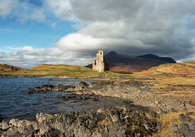
Assynt (Scottish Gaelic: Asainn [ˈas̪ɪɲ] or Asainte [ˈas̪ɪɲtʲə]) is a sparsely populated area in the south-west of Sutherland, lying north of Ullapool on the west coast of Scotland. Assynt is known for its landscape and its remarkable mountains, which have led to the area, along with neighbouring Coigach, being designated as the Assynt-Coigach National Scenic Area,[3] one of 40 such areas in Scotland.[4]

Key Information

The western part of Assynt has many distinctively shaped mountains, including Quinag, Canisp, Suilven and Ben More Assynt, that rise steeply from the surrounding "cnoc and lochan" scenery. These can often appear higher than their actual height would indicate due to their steep sides and the contrast with the moorland from which they rise.[5] Many of the most distinctive peaks such as Suilven were formed during the last Ice Age, when they were left exposed above the ice sheet as nunataks, and they now remain as inselbergs of highly eroded Torridonian sandstone sitting on a bedrock of much older Lewisian gneiss.[6] The Moine Thrust runs through the area, and is most visible at Knockan Crag National Nature Reserve, which includes a visitor centre interpreting the geological features of the landscape. In the east of Assynt lies a region of limestone scenery surrounding Ben More Assynt.[5] This part of Assynt hosts the longest cave in Scotland, Uamh an Claonaite, which lies five miles (eight kilometres) south of Inchnadamph.[7] The geological importance of Assynt is reflected in its inclusion in the North West Highlands Geopark.[8][9]

The name Assynt may derive from an Old Norse word meaning 'ridge end'. There is also a tradition that the name comes from a fight between the two brothers Unt and Ass-Unt, (meaning Man of Peace and Man of Discord). The latter having won the tussle gave his name to the parish.[10] It is celebrated in the poetry of Norman MacCaig.

Local government

[edit]

For many years Assynt was regarded as a district or province of Scotland in its own right, and was later established as a civil parish. With the introduction of counties it became part of the county of Sutherland. Parishes were abolished for administrative purposes in 1930, and counties were replaced by a system of regional and district councils in 1975, however the boundaries of both were retained for statistical purposes (e.g. census figures and land registration) as well for ceremonial purposes such as lieutenancy. The regions and districts were replaced by unitary councils in 1996, and Assynt now forms a community within Highland council area.[11]

Ownership

[edit]

As is typical for the Scottish highlands, the Assynt area is divided into a number of large estates, which are in a mix of private, charitable and community ownership. The Assynt Estate, which includes Ben More Assynt and the lands around Lochinver, remains in the hands of the Vestey family,[12] who also formerly owned the North Assynt Estate (see below).

The Quinag estate belongs to the John Muir Trust,[13] a charity that seeks to conserve wild land and wild places.

The Little Assynt Estate, which comprises two of the old townships of Assynt, Little Assynt and Loch Beannach[14] is now owned by Culag Community Woodland Trust, a local trust that seeks to provide employment and training and improvements in well-being for local people, as well as encouraging education about the area's natural environment.[15]

North Assynt

[edit]
Suilven from the air, showing the steep-sided mountain slopes and rough moorland landscape typical of Assynt.

In 1989, the northwest portion of the Assynt estate was renamed the North Lochinver Estate and put on the market by its owners, the Vestey family. This area consisted almost entirely of crofting land, with 13 crofting townships being set up during the Highland Clearances. The purpose of the sale was to raise money for the owners to buy more hill ground suitable for deer stalking. The estate was purchased by Scandinavian Property Services Limited. Three years later, the company went into liquidation. The North Lochinver Estate was divided into seven lots and put up for sale.[16][17] The sale was handled by an Edinburgh based estate agent, John Clegg and Co.[18] The proposed break-up of the estate was a cause of concern for the crofters as the boundaries of the lots cut across grazing land, creating the possibility of some crofters having to deal with more than one landlord. The crofters also believed that some of the portions would be directly administered by the owners, rather than a professional factor.[19]

The Assynt branch of the Scottish Crofters Union met on the 6 June 1992, to discuss the sale. There the crofters decided to attempt to raise enough money to buy the estate and run it themselves.[20][21]

Assynt Crofters' Trust, a company limited by guarantee, was formed to make a bid for the land. Membership of the trust was open to crofters within the estate. The trust aimed to buy the estate and keep it under the control of the crofters, and to develop the area by initiating projects such as house building, job creation and tree planting.[22] Funding for the trust came from many sources. Each crofting family was asked to raise £1,000. Caithness and Sutherland Enterprise, part of Highlands and Islands Enterprise donated £50,000, while Scottish Natural Heritage gave a grant of £20,000. Highland Regional Council donated £10,000. Much of the money, however, came from a public appeal for funds. This appeal raised over £130,000 from 824 individuals.[23] Money came from throughout the United Kingdom, as well as abroad. Political figures such as the local Member of Parliament, Robert Maclennan,[24] Ray Michie, Alex Salmond, Winifred Ewing and Charles Kennedy donated, as did the rock band Runrig.[23] A secured loan of £90,000 was received from Highland Prospect Limited, a company set up by Highland Regional Council to promote investment in the Highlands by providing grants and low-interest loans.[25]

The trust made two unsuccessful bids, of £235,000 and £245,000 respectively. This caused the trust to adopt a more aggressive stance. They threatened to use right-to-buy provisions of crofting law to buy the crofts.[26] This option, requiring legal action, would be expensive and time-consuming; and would deny the crofters complete control of the estate.[27] The option was therefore kept in reserve in order to make the estate less attractive to other potential bidders—compulsory purchase of the crofts would force the new landowners to sell much of their newly acquired land for a fraction of its value. To assist this strategy, the crofters enclosed and divided an area of common grazing land, an action which would give them the option of buying the common land as well as the crofts themselves. Pressure was also exerted on the main creditor of Scandinavian Property Services, the Swedish Östgöta Enskilda Bank, as the trust wrote telling them of their proposed strategy.[26]

On 4 December 1992, the trust submitted a final bid of £300,000. This was accepted after four days. On Monday, 1 February 1993, Assynt Crofters' Trust became the owners of the North Lochinver Estate, which they renamed the North Assynt Estate.[28]

Glencanisp and Drumrunie Estate

[edit]

In June 2005 the Glencanisp estate, including the mountains Suilven and Canisp and the neighbouring Drumrunie estate, with the mountains Cùl Mòr and Cùl Beag, were bought by the local community.[29] The Assynt Foundation aims to create local employment and safeguard the natural and cultural heritage for the benefit of the community and future generations, and for the enjoyment of the wider public. The estates of Glencanisp and Drumrunie totalling some 18,000 hectares are managed by the Assynt Foundation on behalf of the Assynt community.

Nature and conservation

[edit]
Assynt-Coigach National Scenic Area
Map
LocationHighland, Scotland
Area1,298 km2 (501 sq mi)[30]
Established1981
Governing bodyNatureScot

Assynt has a wide range of habitats, from rocky and sandy shores to high mountains, with areas of woodland, upland heath and dwarf juniper scrubland.[31] The area has a large number of freshwater lochs, which host birds such as black-throated divers.[31] With a highly indented and rocky coastline the area provides excellent habitats for many seabirds, and is one of best places in Europe to see cetaceans such as whales, dolphins and porpoises.[32] Ptarmigan inhabit the mountain areas, where golden eagles may also be seen.[31] Besides the large numbers of red deer, other mammals seen in Assynt include mountain hares, water voles, otters and pipistrelle bat.[31]

The Coigach and Assynt Living Landscape Project is a community partnership project which aims to bring environmental and economic benefits to the Coigach and Assynt regions of North West Scotland. The partnership includes landowners (private and community), the local community and charitable organisations, with the Scottish Wildlife Trust being the lead partner. The project is described as an "ecosystem restoration project", and aims to "bring woodland connectivity, species-rich flora and fauna, and economic growth back to the Scottish uplands".[33]

A large part of Assynt, known as Inverpolly, was formerly designated as a national nature reserve but since 2004 the designation has been limited to the area surrounding Knockan Crag. The Inverpolly area is classified as a Special Area of Conservation, one of three in Assynt along with Inchnadamph and Ardvar and Loch a' Mhuilinn Woodlands. Many of the loch and lochans are designated as Special Protection Areas.[34]

Settlements

[edit]
[edit]

The Disney+ original Star Wars series Ahsoka used the Glencanisp and Drumrunie Estate as an outdoor location with the permission of the Assynt Foundation.

Bibliography

[edit]

References

[edit]
[edit]
Revisions and contributorsEdit on WikipediaRead on Wikipedia
from Grokipedia
![Suilven mountain in Assynt][float-right] Assynt is a remote and sparsely populated historical district and parish in the southwest of Sutherland, within the Scottish Highlands, bounded by the Atlantic coast to the north and west, lochs to the south, and rising to mountains exceeding 900 metres in height to the east.[1][2] Renowned for its dramatic quartzite peaks such as Suilven, Quinag, and Stac Pollaidh, which emerge abruptly from moorland and blanket bog, the region exemplifies the rugged terrain shaped by ancient geological processes.[3][4] Its landscape, part of the North West Highlands Geopark, includes some of Europe's oldest rocks, dating back over three billion years, overlaid by Torridonian sandstones and disrupted by the Moine Thrust fault system from the Caledonian Orogeny around 430 million years ago.[5][6] The area's human history reflects cycles of settlement and displacement, with prehistoric cave dwellings and early Norse influences giving way to clan-based crofting societies that endured the Highland Clearances of the 18th and 19th centuries, which drastically reduced the population through evictions for sheep farming.[7][8] By the 2011 census, Assynt's resident population stood at 1,028, concentrated in villages like Lochinver, with the economy sustained by crofting, fishing, and a growing tourism sector drawn to its wildlife, hiking, and unspoiled vistas.[2] Notable for community-led initiatives, including the 1993 buyout of the North Lochinver Estate from absentee landlords, Assynt has pursued local stewardship of land and resources amid ongoing challenges of depopulation and environmental conservation.[8][9]

Geography and Geology

Physical Landscape

Assynt encompasses approximately 475 square kilometers in southwest Sutherland, northwestern Scotland, extending from the Atlantic coast inland to the Highland boundary fault. The terrain is predominantly rugged and elevated, featuring steep-sided mountains that rise sharply from expansive moorlands and peat bogs, with elevations generally between 300 and 800 meters. This topography results from Pleistocene glacial erosion, which sculpted U-shaped valleys, corries, and a profusion of rocky outcrops amid undulating lowlands.[4][10] Prominent summits define the skyline, including Suilven (731 m), a isolated quartzite ridge with a distinctive tapering profile visible from afar, and the Quinag massif, whose highest point, Sail Gharbh, reaches 809 m across multiple undulating peaks. Other notable peaks such as Canisp (847 m), Ben More Assynt (998 m), and Stac Pollaidh (613 m) contribute to the area's iconic, island-like monadnocks emerging from flatter surrounds. These features create a visually striking mosaic of crags and slopes, interspersed with glacial cirques and scree fields.[11][12][10] The landscape is punctuated by over 300 lochs and lochans, from diminutive hill-tarns to larger bodies like Loch Assynt, which measures roughly 9 km in length and serves as a central hydrological hub fed by rivers such as the Traligill and Loanan. Short, torrential streams drain the moors, channeling peaty waters to coastal outlets amid boggy plateaus and narrow glens. The western coastal margin includes indented fjord-like sea lochs, rocky headlands, and occasional sandy strands, contrasting the interior's barren expanses.[13][10]

Geological Formations and Significance

Assynt's geological framework consists of ancient Precambrian basement rocks overlain by younger sedimentary sequences and disrupted by major thrust faults from the Caledonian Orogeny. The Lewisian Gneiss Complex forms the eroded foreland basement, dating to 3.0–1.7 billion years ago, characterized by banded gneisses and granulites that underwent multiple metamorphic events.[14] Above these lie Neoproterozoic Torridonian sandstones, up to 12 km thick in places, deposited in terrestrial rift basins around 1.2–1.0 billion years ago, forming prominent peaks like Suilven and Canisp due to their resistance to erosion.[15] Cambrian quartzites, including the distinctive Pipe Rock with Skolithos trace fossils and the overlying Fucoid Beds, rest unconformably on the Torridonian, representing shallow marine deposits from approximately 510 million years ago.[15] The defining structural feature is the Moine Thrust Belt, a west-directed thrust zone active during the Silurian period around 430–420 million years ago, where Neoproterozoic Moine Supergroup metasediments—psammites and pelites deformed into schists—were emplaced over the younger foreland rocks, displacing them westward by over 50 km.[16] In Assynt, this manifests in spectacular exposures such as at Stac Pollaidh, where Cambrian quartzite overrides Torridonian sandstone along low-angle thrusts like the Glencoul and Moine Thrusts, with mylonites marking shear zones.[17] The Assynt Culmination, or window, exposes a bulge of Lewisian gneiss and imbricated foreland sheets through the overlying thrust nappes, illustrating duplex structures and strain localization.[16] This region's significance lies in its role as a type locality for thin-skinned tectonics, first elucidated in the late 19th century amid the Highlands Controversy, where mapping by geologists Ben Peach and John Horne in the 1880s demonstrated that older Moine rocks overlie younger strata, overturning earlier vertical tectonics theories.[18] The Moine Thrust Zone provided empirical evidence for large-scale horizontal shortening in orogenic belts, influencing global models of continental collision, as seen in the Alps and Appalachians.[19] Assynt's well-preserved sequences and accessibility have made it a training ground for structural geologists, contributing to UNESCO North West Highlands Geopark status in 2004 for its educational value in plate tectonics and rock deformation processes.[15] Minor Silurian alkaline intrusions, such as microdiorites and rhyolites, further punctuate the succession, offering insights into post-orogenic magmatism.[20]

History

Prehistoric and Medieval Periods

Archaeological evidence indicates prehistoric human activity in Assynt dating to the Neolithic period, characterized by a dense cluster of chambered cairns in the valley between Ledmore Junction and Inchnadamph, reflecting communal burial practices typical of mainland Scotland around 4000–2500 BC.[21][22] Sediment analysis from a crannog site in Assynt reveals human occupation predating an overlying Iron Age structure by over 2500 years, suggesting Neolithic lake-dwelling activity potentially as early as 5500 years ago and representing the earliest such evidence on mainland Scotland.[23][24] Bronze Age and Early Iron Age materials, including artifacts from Creag nan Uamh bone caves, further attest to continued settlement and resource use in the region, with finds linking to broader Atlantic seaboard patterns.[25] Iron Age occupation is prominently evidenced by brochs, such as Clachtoll Broch overlooking Stoer Bay, a drystone roundhouse constructed around the 2nd century BC and occupied into the early centuries AD, yielding imports like Mediterranean pumice and Italian ceramics indicative of long-distance trade networks.[26][27] Additional Iron Age sites include complex Atlantic roundhouses and agricultural remains, underscoring a shift toward fortified settlements amid environmental challenges.[22] ![Ardvreck Castle ruins on Loch Assynt][float-right] During the medieval period, Assynt fell under Gaelic lordship, with lands granted in 1343 by King David II to Torkyll MacCloyd (MacLeod) of Lewis, establishing the MacLeods of Assynt as hereditary proprietors.[28] This clan constructed Ardvreck Castle around 1490 on a promontory in Loch Assynt, serving as their stronghold and symbolizing feudal control over the parish's dispersed townships.[29] The MacLeods maintained authority through the late Middle Ages, overseeing a kin-based society reliant on pastoralism and fishing, though records of earlier Norse incursions in Sutherland suggest possible prior Viking influences on local tenurial structures.[30] Inchnadamph emerged as a medieval focal point, featuring the clan's burial vault and remnants of ecclesiastical sites tied to the Diocese of Caithness.[29]

Highland Clearances and Crofting Emergence

The Highland Clearances in Assynt, part of the broader Sutherland evictions from 1811 to 1823, involved the systematic removal of tenants from inland townships to facilitate large-scale sheep farming, which offered higher profitability amid post-Napoleonic economic demands and estate debts.[8] In 1812, factor Patrick Sellar oversaw clearances in Assynt districts, destroying homes and forcing relocation to prevent reoccupation, as part of efforts by the Sutherland estate—into which Assynt had passed after its 1757 sale to Lady Strathnaver—to convert communal grazing lands into sheep runs managed by lowland tenants.[31] Approximately 15,000 people across Sutherland, including those in Assynt, were affected, with interior settlements abandoned and ruins persisting as evidence of the depopulation.[8] These actions prioritized commercial agriculture over traditional subsistence systems, reflecting causal pressures from rising wool demand and the unsustainability of overpopulated clan-based tenancies post-1745 Jacobite defeat. Surviving tenants were resettled on marginal coastal lands in smaller holdings known as crofts, marking the emergence of crofting as a distinct tenure system in Assynt by the early 19th century.[32] This relocation consolidated evicted families into compact townships—estimated at around 13 in Assynt—where crofts averaged a few acres of arable land supplemented by common grazings, fishing, and kelp harvesting for income.[8] Crofting thus arose not as a deliberate reform but as a pragmatic containment strategy by landlords, providing minimal subsistence while freeing prime interior land for sheep, though yields remained low due to poor soil and exposure.[32] The system endured amid ongoing insecurity until the Napier Commission's 1883–1884 inquiries into Highland grievances prompted the Crofters Holdings (Scotland) Act 1886, granting Assynt crofters limited security of tenure and fair rents, formalizing crofting as a statutory framework.[33] This legislation addressed abuses like arbitrary evictions but preserved the small-scale structure born of clearances, with Assynt's coastal crofting townships sustaining sparse populations through mixed economies rather than enabling full agricultural viability.[8] Empirical records from estate factors confirm that pre-clearance Assynt supported denser inland settlements via runrig communal farming, underscoring how sheep-driven economics causally displaced these for export-oriented pastoralism.[34]

Modern Land Reforms and Events

In the late 20th century, Assynt's crofting communities continued to grapple with insecure tenure and absentee ownership, prompting organized resistance to estate sales. The North Assynt Estate, spanning approximately 21,000 acres and encompassing crofts, common grazings, and sporting interests, had been sold by the Duke of Westminster in 1976 to overseas investors associated with Scandinavian Airlines' pension fund. By 1992, these owners sought to divest the property amid financial pressures, initially agreeing to sell it to a local timber merchant, which galvanized local crofters to form the Assynt Crofters' Trust in September of that year.[8] The Trust invoked provisions under existing crofting legislation, including security of tenure and rights to challenge sales affecting crofts, to negotiate directly with the sellers and threaten individual croft purchases, which could fragment the estate and deter private buyers. Supported by Highlands and Islands Enterprise, the group raised £300,000 through public donations, lottery grants, bank loans, and Scottish Office funding, enabling a collective purchase rather than piecemeal acquisitions. On February 1, 1993, title to the estate transferred to the Trust, averting private monopoly and marking the first large-scale community acquisition of a Highland estate in modern times.[35][36][37] This event, driven by grassroots mobilization rather than new statutory compulsion, influenced subsequent national reforms by demonstrating viable community management of land for crofting, conservation, and economic diversification. It preceded the Crofting Reform (Scotland) Act 1993, which expanded crofters' rights to acquire common grazings, and contributed to the broader Land Reform (Scotland) Act 2003, establishing a statutory community right to buy land when it comes on the market. In Assynt, the Trust's model evolved into the Assynt Foundation in 2013, facilitating further initiatives like the creation of 10 new crofts announced in 2016 to combat depopulation and revive traditional land use.[38][39][40]

Ownership and Land Tenure

Traditional Clan and Laird Ownership

Assynt was historically the territory of the MacLeods of Assynt, a branch of Clan MacLeod originating from the Siol Torquil line, who held the lands from at least the 13th century as lairds under the feudal clan system.[41] The MacLeods constructed Ardvreck Castle around 1490 on a promontory in Loch Assynt, serving as their principal stronghold and symbolizing their authority over the region.[28] In this traditional setup, the laird functioned as clan chief, with tenants as kinsmen enjoying heritable occupancy rights in exchange for military service and rents, though increasingly monetized by the 17th century.[42] A pivotal event occurred in 1650 when Neil MacLeod, the 10th Laird of Assynt, captured the defeated Royalist leader James Graham, Marquess of Montrose, who sought refuge near Ardvreck Castle after the Battle of Carbisdale.[43] Montrose was handed over to Covenanter forces, earning Neil a £25,000 reward from Parliament, but this led to prolonged lawsuits by Montrose's family seeking restitution, which, combined with other debts, financially ruined the MacLeods.[44] By 1695, unable to meet obligations, the estate was transferred to the Mackenzies of Seaforth, marking the end of MacLeod control.[41][45] The Mackenzies assumed lairdship, designating John Mackenzie "of Assynt" by 1690, though formal acquisition finalized in 1695, shifting ownership to lowland-influenced proprietors who prioritized estate revenues over clan ties.[41] This period saw Assynt sequestered in 1739 due to Mackenzie bankruptcy from Jacobite involvements and financial mismanagement.[41] The estate was then sold at public auction in 1757 to Lady Strathnaver of the Sutherland family, transitioning to larger aristocratic holdings that presaged later agrarian changes, while retaining laird-centric tenure.[41] Under these lairds, traditional tacksmen and sub-tenants managed subdivided farms, but growing commercial pressures eroded customary clan protections.[46]

The North Assynt Estate Buyout of 1993

In 1989, the Vestey family, long-term owners of much of the Assynt region, sold the North Lochinver Estate in three lots for over £1 million, with one portion acquired by Swedish timber speculator Tom Strunz, who subsequently faced bankruptcy.[35][47] Liquidators then sought to dispose of the 21,000-acre estate, proposing its division into smaller parcels for private sale, which threatened crofting tenancies and local access rights.[8][48] Local crofters, facing potential loss of control over common grazing lands and fearing fragmentation, formed the Assynt Crofters' Trust in 1992 under the leadership of Allan Macrae to mount a collective bid.[49][37] The trust launched a public fundraising appeal on July 28, 1992, securing approximately £145,000 from Highlands and Islands Enterprise, alongside donations, grants from charitable trusts, and local contributions totaling £300,000 for the purchase.[37][50] A deal was finalized with the liquidators in December 1992, averting rival private bids and preserving the estate's unity.[37][48] On February 1, 1993, the Assynt Crofters' Trust received legal title to the estate, renaming it the North Assynt Estate and marking the first successful community buyout of a large Scottish landed estate from liquidation.[8][35] This event, involving 13 crofting townships such as Clachtoll and Stoer, shifted ownership from absentee landlords to local stakeholders, enabling democratic management of resources like hill grazings and coastal areas.[51][50] The buyout relied on pre-existing crofters' rights under the 1886 Crofters Holdings Act but highlighted limitations in legislation, spurring subsequent reforms including the 1993 Croft Reform Act and the 2003 Land Reform (Scotland) Act.[36][52] Post-purchase, the trust prioritized sustainable crofting, habitat restoration, and community benefits, though challenges persisted, including deer management disputes and economic pressures on remote holdings.[53][54] The model demonstrated that community ownership could prevent land speculation and support local decision-making, influencing over 70 subsequent buyouts across Scotland by 2002.[55][37]

Contemporary Estates and Private Holdings

The North Assynt Estate, encompassing approximately 21,300 acres of coastal, moorland, and hill terrain, is owned and managed by the Assynt Crofters' Trust since its community acquisition on February 1, 1993. This trust, representing local crofters from thirteen townships including Clachtoll, Stoer, and Culkein Drumbeg, prioritizes sustainable crofting, hill grazing, and habitat restoration while generating income through leasing and grants.[51] The Glencanisp and Drumrunie Estates, totaling 44,000 acres and featuring landmarks such as Suilven and Canisp, were purchased by the Assynt Foundation—a community-led charity—from the Vestey family in 2005 for community benefit. Recent initiatives include a 2024 partnership with Woodland Trust Scotland for native woodland planting across thousands of acres and a 25-year lease of Glencanisp Lodge for boutique hotel operations, aimed at enhancing economic viability amid past financial challenges.[56][57][58] Quinag, a 2,500-hectare estate centered on the Quinag massif, remains under the ownership of the John Muir Trust, a conservation charity that emphasizes wild land protection and public access. Tensions arose in 2023 when the trust increased red deer culls to promote woodland regeneration, prompting criticism from the Assynt Crofters' Trust over impacts on shared grazing and calls for a community buyout, which has not materialized as of 2025.[59][60] The Little Assynt Estate, covering 1,200 hectares of woodland and open ground near Loch Assynt, has been owned by the Culag Community Woodland Trust since its 2000 purchase, with management focused on biodiversity enhancement, trail development, and community involvement through projects like all-abilities paths.[61][62] Private holdings in Assynt are predominantly smaller-scale, consisting of individual crofts, houses, and fragmented plots integrated into townships, often under common grazing committees rather than large estates. Broader land reform has shifted dominance from historic private lairdships to community and charitable entities, though some private owners participate in partnerships like the Coigach & Assynt Living Landscape for habitat connectivity and rewilding efforts.[63][64]

Economic and Social Structure

Primary Industries and Employment

Assynt's primary industries center on crofting, fishing, and tourism, which together underpin much of the local employment in this remote rural area. Crofting, characterized by small-scale livestock rearing—primarily sheep (27 respondents) and cattle (14 respondents) among surveyed crofters—remains a foundational activity, supplemented by limited horticulture (17 respondents) and environmental practices like woodland planting. These operations often provide supplementary rather than primary income, with many crofters engaging in part-time work elsewhere due to low financial returns from agriculture alone.[65][9] Fishing, particularly in coastal Lochinver, constitutes a vital sector, with the harbor functioning as a key west coast port for whitefish landings and processing, supporting direct and indirect jobs in catching, handling, and related services. The industry contributes to the broader Highland economy but faces challenges from fluctuating quotas and vessel employment declines observed nationally, with Scottish fishing vessel employment dropping 13% since 2014.[66][67] Tourism has emerged as a critical employment driver, leveraging Assynt's dramatic landscapes for activities like angling, hiking, and marine pursuits, with accommodation and food services ranking among top sectors per the 2011 Census. Local plans identify tourism promotion—especially marine-based opportunities in Lochinver—as the primary avenue for economic growth, amid increased visitor traffic from routes like the North Coast 500. Self-employment stands at 22.8%, often in tourism-related ventures such as bed-and-breakfasts and self-catering (9 respondents), though seasonal patterns exacerbate concerns over year-round job scarcity. Overall, agriculture, forestry, and fishing account for a disproportionate share of rural Highland employment at around 15%, reflecting Assynt's reliance on these primary activities amid limited diversification.[9][65][68]

Population Dynamics and Depopulation

The population of Assynt experienced initial growth in the 18th and early 19th centuries, rising from approximately 1,800 in 1760 to 3,183 by the 1831 census, driven by the introduction of potato cultivation that supported higher densities on marginal lands.[69] This expansion, however, was disrupted by the Highland Clearances, particularly in the early 19th century under landlords like the Duke of Sutherland, whose agents evicted tenants from inland glens to make way for sheep farming.[8] In broader Sutherland, these evictions displaced around 15,000 people between 1811 and 1823, forcing many in Assynt to coastal crofts or prompting emigration to urban lowlands and overseas destinations such as Canada and Australia, initiating a pattern of inland depopulation.[8] [70] By the late 19th century, Assynt's population had stabilized at around 3,161 in 1891, but the shift to crofting on poorer coastal soils, combined with the potato famine of the 1840s, accelerated emigration and prevented recovery.[71] The 20th century saw further decline due to limited economic opportunities, with young residents migrating to industrial centers in the Scottish Central Belt for employment and education, leaving an aging demographic and hollowing out communities.[70] This outmigration reflected broader Highland trends, where population halved in Sutherland from the mid-19th century to around 13,000 by 2020, exacerbated by low birth rates and dependence on subsistence agriculture and fishing.[72] The 2011 census recorded just 1,028 residents in Assynt, underscoring a sustained depopulation that reduced density to among Scotland's lowest, with settlements like Lochinver holding the largest share but overall numbers insufficient to sustain local services.[2] Contemporary dynamics include an elderly median age, net outmigration of working-age individuals, and vulnerability to external shocks like declining fisheries, though community land ownership since 1993 has aimed to mitigate decline through housing and business initiatives.[73] Despite these efforts, nearby North West Sutherland saw an 8.8% drop over two decades to 2025, signaling persistent challenges from structural economic constraints rather than acute crises.[74]

Community Initiatives and Challenges

Community-led land ownership has been a cornerstone of initiatives in Assynt since the 1993 buyout of the North Assynt Estate by local crofters, which established a model for sustainable management and inspired subsequent efforts.[35] The Assynt Foundation, formed in 2005, secured the 18,000-hectare Glencanisp and Drumrunie estates through a £2.9 million community raise, emphasizing landscape preservation, red deer management, and cultural projects like the Red Deer Arts Residency.[56] Complementing this, the Assynt Development Trust has pursued economic and housing development, including the 2021 acquisition of Lochinver Glebe land from the Church of Scotland to build affordable homes for families and young people, alongside community asset transfers such as Culag Park in 2010–2011.[75] [76] Conservation and wellbeing partnerships form another key strand, with the Coigach & Assynt Living Landscape project fostering environmental restoration and local economic benefits through collaborative land management.[77] The South Assynt Collaboration, a 30-year initiative launched in collaboration with the Woodland Trust, targets ecosystem restoration to support community livelihoods and biodiversity.[78] Social support initiatives, such as those by Community Care Assynt—a Lochinver-based charity—provide daily lunches, transport, and activity clubs to combat isolation among the elderly, relying on volunteer networks.[79] The Assynt Community Plan, developed through partnerships with bodies like NHS Highland and Highland Council, prioritizes youth opportunities (£1.34 million allocated), marine tourism at Lochinver harbour (£1.27 million), and digital infrastructure improvements (£580,000).[80] Despite these efforts, Assynt faces entrenched challenges, including acute depopulation that has reduced Highland areas to densities lower than Lapland's, exacerbating an aging demographic and workforce shortages.[74] Housing shortages persist, driven by a high proportion of second and holiday homes, limiting family retention and contributing to rural-urban migration.[80] Economic vulnerabilities include reliance on seasonal tourism and fishing, poor non-seasonal job availability, inadequate transport links, and unreliable broadband, which hinder service sustainability and broader regeneration.[80] Community buyouts have encountered operational strains, as seen in the Assynt Foundation's recovery from partnership issues in 2019 through new collaborations by 2025.[81] These factors underscore the tension between ambitious local governance and structural barriers to demographic and economic stability.[82]

Nature, Conservation, and Resource Management

Biodiversity and Ecosystems

Assynt's ecosystems exhibit high diversity across its coastal, freshwater, woodland, and upland habitats, shaped by the region's oceanic climate with high rainfall and exposure. Blanket peatlands and moorlands dominate the uplands, comprising acidic mires modified by historical peat extraction, burning, and grazing, yet supporting specialized flora such as Calluna vulgaris (heather), sphagnum mosses, and insectivorous Drosera species. These wetlands act as carbon sinks and habitats for invertebrates, amphibians, and ground-nesting birds.[83][84] Scattered woodlands, including Atlantic oakwoods and birch-hazel stands, occur in sheltered glens and coastal margins, fostering bryophyte- and lichen-rich understories due to humidity. Oaks (Quercus petraea) in areas like Achduart host over 280 insect species reliant on the tree, alongside fungi and herb-rich ground flora such as bluebells (Hyacinthoides non-scripta) and meadow buttercups (Ranunculus acris). Alpine and subalpine zones on peaks like Suilven feature rare vascular plants, including Pyrus aria (whitebeam), Leontodon autumnalis, and Luzula spicata. Freshwater lochs, often oligotrophic, sustain aquatic macrophytes like Lobelia dortmanna, Ranunculus flammula, and Littorella uniflora, supporting pearl mussels (Margaritifera margaritifera) and fish communities.[85][86] Fauna includes red deer (Cervus elaphus) roaming moors, otters (Lutra lutra) along waterways and coasts, and Scottish wildcats (Felis silvestris) in remnant woodlands. Avifauna is prolific, with over 200 species recorded, featuring golden eagles (Aquila chrysaetos) nesting in mountains and preying on ptarmigan, alongside white-tailed eagles (Haliaeetus albicilla), divers, and seabirds like common scoter (Melanitta nigra). Coastal zones host seals and dolphins, while invertebrates thrive in peat and woods. This biodiversity reflects Assynt's intact wild character, though pressures from grazing and climate affect habitat integrity.[1][87][88]

Conservation Designations and Projects

Assynt encompasses multiple protected designations that safeguard its geological, ecological, and scenic attributes. The Coigach-Assynt National Scenic Area, designated on 17 December 2010, spans 90,200 hectares and preserves the region's dramatic quartzite mountains, moorlands, and coastal features against developments that could impair their visual quality.[89] Ben More Assynt qualifies as a Site of Special Scientific Interest (SSSI) due to its geological exposures of Precambrian rocks and associated habitats, managed by NatureScot to maintain scientific integrity.[90] Inchnadamph National Nature Reserve protects limestone cave systems and alpine flora, including rare arctic-alpine plants, serving as a key site for geological and biological study.[3] The area includes two Special Areas of Conservation (SACs) under the EU Habitats Directive, focusing on habitats such as blanket bog, coastal dunes, and machair, alongside the Loch Assynt and nearby lochs Special Protection Area (SPA), which safeguards breeding sites for black-throated divers (Gavia arctica).[63][91] Assynt also falls within the North West Highlands UNESCO Global Geopark, recognizing its Lewisian gneiss formations and Torridonian sandstones as internationally significant, and the Wester Ross Marine Protected Area restricts destructive fishing to conserve seabed geology and biodiversity.[63][87] Major conservation projects emphasize habitat restoration and community involvement. The Coigach & Assynt Living Landscape Partnership (CALLP), active from 2015 to 2020, coordinated over 30 initiatives across 635 square kilometers, partnering landowners, charities like the Scottish Wildlife Trust, and communities to restore peatlands, native woodlands, and marine habitats while fostering economic benefits through eco-tourism.[92][93] The ongoing South Assynt Collaboration Project, launched in 2025 as a 30-year effort by the Assynt Foundation, Woodland Trust Scotland, and Aviva, targets the creation of 2,000 to 2,500 acres of new native woodland within the first five to ten years, alongside peatland restoration and temperate rainforest expansion on 23,000 acres of former sheep grazing land.[94][78] Additional initiatives include the Assynt Foundation's deer management and invasive species control to enhance biodiversity on community-owned estates, and a 2022 community-led marine monitoring project tracking habitats, invasive species like Didemnum vexillum, and climate impacts in coastal waters.[91][95] A 2025 project by Scottish Forestry protects a rare refuge population of elm trees (Ulmus spp.) against Dutch elm disease, preserving genetic diversity in this isolated highland stand.[96] These efforts prioritize evidence-based restoration, drawing on empirical monitoring of species recovery and habitat metrics rather than unsubstantiated ecological assumptions.

Conflicts in Wildlife and Land Management

In Assynt, conflicts in wildlife and land management primarily revolve around red deer populations and their impact on habitat restoration versus traditional sporting and crofting interests. The Quinag estate, managed by the John Muir Trust (JMT) since its acquisition in 2005, exemplifies this tension, where elevated deer densities have hindered regeneration of native Atlantic oakwoods and peatlands classified as Sites of Special Scientific Interest (SSSIs).[97] [59] Monitoring data indicate that browsing has damaged over 150 tagged woodland seedlings since 2016, contributing to Quinag's annual emission of approximately 5,000 tonnes of CO2 equivalent and preventing potential sequestration of 8,800 tonnes annually through restored habitats.[59] To address overgrazing, the JMT has intensified culls, authorized by NatureScot for out-of-season and nighttime operations until March 2023, including instances of 24 stags removed over two days in winter 2022.[98] [59] Peninsula-wide deer counts, coordinated through the now-defunct Assynt Peninsula Sub-Group, revealed a 40% population increase from 1,383 in 2011 to 1,921 in spring 2022, prompting these measures to align with Scottish Government biodiversity targets.[59] The JMT maintains that such reductions support long-term ecological health without proven economic detriment to neighboring estates, many of which operate at annual losses exceeding £100,000.[59] Local opposition, led by the Assynt Crofters Trust (ACT) and Scottish Gamekeepers Association (SGA), contends that aggressive culling undermines deer stalking revenue—estimated at £30,000 annually for the community, with each deer valued at around £1,000—and risks job losses in a region reliant on rural employment.[97] Critics have lodged formal complaints against the JMT for welfare issues, such as a 2015 incident where 86 culled deer were left to decompose and a 2023 case involving a severely wounded stag near Quinag boundaries, and for insufficient consultation, culminating in the JMT's withdrawal from collaborative deer management groups.[97] [98] In response, the ACT explored a community buyout of Quinag in 2023 to prioritize sustainable stalking alongside conservation.[99] This dispute traces to earlier frictions at sites like Ardvar, where Scottish Natural Heritage (now NatureScot) since 2014 has advocated deer reductions to 7 per km² for woodland recovery, countering local assertions of adequate natural regeneration (e.g., 400 stems per hectare documented in 2016).[54] Broader analyses frame such standoffs as multi-layered, encompassing ecological imperatives against socioeconomic dependencies in upland areas, with no natural predators sustaining deer numbers amid fragmented management.[100] While conservation advocates cite empirical evidence of grazing's inhibitory effects on biodiversity, stakeholders emphasize balanced approaches to avert undue pressure on crofting viability.[54][59]

Cultural and Recreational Impact

Settlements and Local Life

Assynt's settlements consist primarily of small crofting townships and coastal villages scattered across its rugged terrain, reflecting a low-density rural pattern shaped by historical land use and geography. The region lacks large towns, with communities centered around traditional crofts—small-scale holdings typically under 10 hectares used for mixed farming, livestock grazing on common hill land, and subsistence activities.[101][102] Lochinver serves as the largest settlement, functioning as a key fishing port and service hub with a harbor supporting a whitefish and shellfish fleet that lands approximately 5,000 tonnes annually. Home to around 500 residents, it provides amenities including shops, a post office, and the North West Highlands Geopark visitor center, sustaining local employment in processing and tourism.[103][66] Other notable villages include Scourie, a coastal community with a sandy beach and historical ties to fishing and crofting; Kylesku, known for its bridge spanning the Kyle of Assynt and serving as a former ferry point with a hotel and basic services; and Inchnadamph, located near Loch Assynt and offering lodging, a hostel, and access to hiking trails amid the area's mountains. These smaller hamlets, such as Stoer and Inverkirkaig, typically comprise clusters of whitewashed croft houses grouped for communal field work and grazing rights under the Crofting Reform Act.[104][105] Local life revolves around crofting as a part-time occupation, where residents maintain sheep flocks—Assynt supports around 10,000 breeding ewes—and cultivate potatoes or hay on inbye land, often combining this with off-croft work in fisheries, seasonal tourism, or public services to counter economic marginality. The 2011 census recorded Assynt's population at 1,028, predominantly in crofting households, with Gaelic spoken in some homes preserving cultural traditions amid ongoing challenges like youth outmigration and infrastructure limitations in this remote area. Community events, such as mod singing competitions and hill sheep dog trials, foster social cohesion in these tight-knit townships.[2][106][101]

Representation in Literature, Art, and Media

The Scottish poet Norman MacCaig (1910–1996) produced approximately 140 poems focused on the landscapes and inhabitants of Assynt, drawing from his frequent visits to the region starting in the 1940s.[107] His works, such as "A Man in Assynt" (first published in 1971), evoke the area's rugged terrain through vivid imagery of indifferent natural forces like wind and water shaping "masterless" valleys.[108] Collections including Between Mountain and Sea: Poems from Assynt (2018) compile these pieces, contrasting Assynt's wild isolation with urban life in poems like "Assynt and Edinburgh."[109] Other literary depictions include historical accounts of angling, such as J. Hicks's 1855 book Wandering the Lochs and Streams of Assynt, an early record of the region's fishing heritage.[110] Contemporary novels by Mandy Haggith, who resides in Assynt, are set amid its coastal and inland settings, exploring local themes in works like her five novels completed by 2023.[111] Travel writing also features, as in Val McDermid's 2019 memoir extract describing the "magic" of Assynt's Hermit's Castle near Lochinver.[112] In visual art, Assynt's dramatic geology has inspired landscape representations, notably David Young Cameron's 1936 etching The Wilds of Assynt, which captures the area's untamed moors and peaks held by Perth & Kinross Council.[113] Modern artists continue this tradition with expressionist oils of sites like Lochinver Bay and Ben More Assynt, emphasizing the region's stark, elemental beauty.[114] Surreal influences appear in works by artists raised in Assynt's Gaelic-speaking communities, incorporating linguistic and cultural motifs into abstract forms exhibited as of 2017.[115] Assynt's portrayal in film, television, and broader media remains limited, with primary appearances in documentary footage of Highland ecology rather than narrative productions.[116] Local celebrations, such as 2010 events marking MacCaig's centenary, have included video tributes reciting his Assynt-inspired verse.[117]

References

User Avatar
No comments yet.