Hubbry Logo
Aurès MountainsAurès MountainsMain
Open search
Aurès Mountains
Community hub
Aurès Mountains
logo
8 pages, 0 posts
0 subscribers
Be the first to start a discussion here.
Contribute something
Aurès Mountains
Aurès Mountains
from Wikipedia

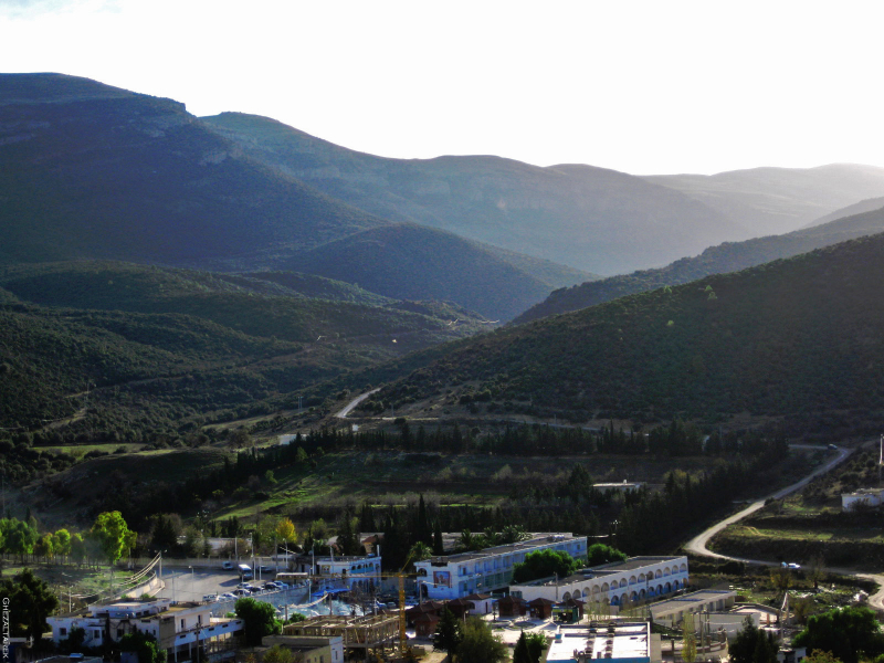
The Aures Mountains (Arabic: جبال الأوراس, known in antiquity as Latin: Aurasius Mons) are a subrange of the Saharan Atlas in northeastern Algeria.[2] The mountain range gives its name to the mountainous natural and historical region of the Aurès.

Key Information

Geography

[edit]

The Aures mountains are the eastern continuation of the Saharan Atlas. The highest peak in the Aurès mountain range is Djebel Chélia in Khenchela Province, which sits at 2,328 metres (7,638 ft).

The Belezma Range is a northwestern prolongation of the Aures Mountains located where the Tell Atlas and the Saharan Atlas come together. Its main summits are 2,178 m (7,146 ft) high Djebel Refaâ and 2,136 m (7,008 ft) high Djebel Tichaou.[3] The Atlas chain of mountains extends over 1000 kilometers in total over Northern Africa.

History

[edit]

Historically, the Aures served as a refuge and bulwark for the Berber tribes, forming a base of resistance against the Romans, Vandals, Byzantine, and Arabs along the centuries.[4]

The mountain area was also a district of French Algeria that existed during and after the Algerian War of Independence from 1954 to 1962. It was in this region that the Algerian War of Independence was started by Berber freedom fighters. The rugged terrain of the Aures makes it still one of the least developed areas in the Maghreb.

Population

[edit]

In eastern Algeria, the Aures is a large Berber-speaking region, home of the Chaoui people. The Chaoui eastern Berber population practices traditional transhumance, farming fixed stone terraces in the mountains where they grow sorghum, as well as other grains and vegetables. Seasonally they move their cattle to relatively warm areas in the lowland valleys where they pitch tents or live in other temporary structures and tend livestock through the winter.[5]

Features

[edit]

See also

[edit]

References

[edit]
[edit]
Revisions and contributorsEdit on WikipediaRead on Wikipedia
from Grokipedia
The Aurès Mountains constitute a rugged subrange of the in northeastern , extending into northwestern , characterized by steep northern cliffs and southward-opening plateaus. The range's highest peak, Djebel Chélia, rises to 2,328 meters in Province, marking one of northern 's most prominent elevations amid a landscape of snow-capped summits in winter and diverse ecosystems supporting endemic flora and fauna. Inhabited primarily by the , a Berber ethnic group native to the region and known for their pastoral traditions and distinct Tachawit language, the Aurès has historically functioned as a natural fortress, facilitating indigenous resistance against Roman, Byzantine, , and French forces over millennia. This strategic topography contributed to pivotal events, including the 7th-century leadership of Berber queen Dihya () against conquests and guerrilla operations during the of Independence.

Geography

Location and Physical Extent

The Aurès Mountains constitute a subrange of the , located in northeastern , northern . They primarily span the provinces of Batna, , and , with their central coordinates approximately at 35°20′ N, 6°40′ E. This positioning places the range between the high plains of eastern to the north and the to the south, extending eastward toward the Algerian-Tunisian border. The physical extent of the Aurès Mountains covers roughly 9,000 square kilometers and measures about 200 kilometers in length, oriented generally east-west. Bounded by steep northern cliffs that demarcate it from the Tell Atlas, the range transitions southward into broader valleys, including Wadis Abiod and ʿAbdi, before merging with the Saharan expanse. Elevations vary significantly, with peaks often snowcapped in winter; the highest point, Djebel Chélia in Khenchela Province, attains 2,328 meters.

Geology and Topography

The Aurès Mountains constitute the eastern segment of the , shaped primarily by tectonic shortening linked to the northward drift of the African plate toward during the . This convergence deformed pre-existing rift basins, with surface exposures preserving sediments from the Permian to deposited amid Pangea's fragmentation. Ongoing shortening at rates of 1–3 mm/year, accompanied by right-lateral strike-slip motion, sustains active reverse and strike-slip faulting along the range's margins, contributing to flexural development. The geological substrate features predominantly sedimentary lithologies, including , , , and , with prominent sequences such as the upper –lower formations (Arris, Adahri, Yabous, and Bou Ouali) and deposits in the Basin. These reflect a paleogeography of progressively deepening marine environments from southwest to northeast. Crustal structure transitions from thinner crust (~22 km Moho depth) in the adjacent Tell Atlas to thicker (~42 km) beneath the northern edge, correlating with elevated via partial isostatic compensation. Topographically, the range exhibits rugged, dissected terrain with northern escarpments and southern valleys, averaging elevations around 1,964 meters. The highest summit, Djebel Chélia, reaches 2,328 meters, marking northern 's apex and occasionally snowcapped in winter. Subranges like the western Belezma feature steep slopes and karstic elements, while the overall relief supports limited development due to steep gradients and endorheic drainage patterns.

Climate, Hydrology, and Biodiversity

The Aurès Mountains feature a with strong continental influences, marked by hot, dry summers and cold winters prone to snowfall at higher elevations. In Batna, a key city in the region, average annual measures about 305 mm, with minimal rainfall in summer (as low as 5 mm in ) and peaks in autumn and spring. Temperatures fluctuate widely; summers often exceed 30°C during the day, while winter nights can drop below freezing, reflecting the inland position and elevation gradients that amplify diurnal and seasonal variations. Recent trends indicate warming and reduced , exacerbating conditions and impacting local and . Hydrologically, the range is characterized by ephemeral wadis—seasonal rivers fed by sporadic rainfall and —that originate from steep slopes and converge into larger valleys before draining into endorheic basins like Chott Melghig. These watercourses exhibit high variability, with flows concentrated during brief wet periods and drying up in prolonged droughts, limiting perennial . Traditional systems, such as foggaras and canals, historically supplemented scant resources in oases, but diminishing wadi flows due to climate shifts have strained these networks. aquifers in fractured formations provide additional supply, though poses risks in this arid setting. Biodiversity in the Aurès is concentrated in relictual cedar forests and higher-altitude habitats, where Atlas cedar (Cedrus atlantica) dominates alongside pines and oaks, supporting specialized insect and bird communities. Avian surveys in cedar stands have documented 24 breeding species, with habitat preferences tied to canopy density and understory cover. Mammalian fauna includes Barbary sheep (Ammotragus lervia), wild boar, and elusive predators, while protected areas like Belezma National Park harbor 309 faunal species, among them 59 protected taxa such as Cuvier's and Dorcas gazelles. Aquatic macroinvertebrates, including mayflies of the family Baetidae, thrive in headwater streams, underscoring the range's role as a biodiversity hotspot amid surrounding arid lowlands; however, deforestation and climate pressures have led to declines in forest cover and endemic populations.

History

Prehistory and Ancient Civilizations

The Aurès Mountains region exhibits evidence of early hominin occupation dating to the period, with stone tools and cutmarked bones recovered from sites such as Aïn Boucherit near Aïn Hanech, indicating Oldowan-like technology and an age of approximately 2.4 million years. Additional artifacts, including lithic industries, have been identified at N'Gaoues in within the Aurès massif, underscoring the area's role in early tool-using populations adapted to Pleistocene environments. These findings, supported by paleomagnetic and biochronological analyses, reflect sporadic but persistent human activity amid landscape morphogenesis, with recent surveys documenting 43 new prehistoric sites linking climatic shifts to settlement patterns. During the , the Capsian culture dominated the broader northeastern Algerian highlands, including fringes of the Aurès such as the Tébessa region, from roughly 8000 to 2700 BCE, characterized by microlithic tools, escargotières (snail middens), and economies exploiting local and . This culture, distinct from Ibero-Maurusian traditions to the west, featured semi-sedentary camps with evidence of seasonal mobility, fire use, and early wild plant processing, as seen in ash-rich deposits and remains from nearby systems. The transition around 6800 calibrated years BP introduced and , evidenced at Grotte Capéletti in the Aurès, where faunal assemblages indicate herding of caprines alongside continued , marking a shift toward agro-pastoral adaptations in the mountainous terrain. In antiquity, the Aurès formed a core territory of the kingdoms, inhabited by Berber tribes such as the in the east, whose domain encompassed much of the range and served as a strategic highland base from the BCE onward. Unified under kings like after 202 BCE, allied variably with and , leveraging Aurès cavalry for military prowess until its annexation following Jugurtha's defeat in 46 BCE. Roman incorporation elevated the region to provincial status in by 197–198 CE under , with military installations like (housing Legio III Augusta) and colonies such as —founded ex nihilo by in 100 CE to secure Saharan passes—featuring forums, aqueducts, and defenses against Berber incursions. Sites like Theveste and (Hammam Essalhine) attest to Roman engineering, including and roads, yet the rugged Aurès repeatedly harbored resistance, as Berber groups exploited the topography for guerrilla tactics against imperial control.

Medieval Period and Islamic Conquests

The Aurès Mountains served as the heartland of the independent Christian Berber , established in the 480s CE by King Masties amid revolts against the that had overrun Roman . This realm, centered in the rugged terrain of present-day northeastern , maintained semi-autonomy under nominal Byzantine influence while fending off external pressures, including Vandal incursions and later Byzantine reconquests in the . The kingdom's strategic location in the Aurès provided natural fortifications, enabling Berber rulers to preserve local governance and Christian practices amid the fragmentation following the Western Roman Empire's collapse. As Arab Muslim forces advanced into the under the , the emerged as a focal point of Berber resistance in the late . Berber leader , a Christian chieftain of the Awraba tribe possibly ruling from the , allied with Byzantine remnants to and kill Uqba ibn Nafi's in 683 CE near modern , temporarily halting the invasion. However, Arab reinforcements under Husayn ibn Numayr defeated and killed around 688 CE at the Battle of Mamma, allowing Umayyad forces to consolidate control over eastern while Berber tribes in the regrouped. Subsequent resistance coalesced under Dihya, known to Arabs as al-Kahina ("the soothsayer"), a Berber prophetess and military leader of the Jarawa (Zenata) tribe based in the Aurès Mountains. In 695 CE, she decisively defeated Umayyad general Hasan ibn al-Nu'man at the Battle of Meskiana, forcing his retreat to Libya and establishing a confederated Berber state extending from the Aurès to the Ghadames oasis, which she ruled until approximately 700 CE. Employing scorched-earth tactics—destroying olive groves and crops to deny resources to invaders—al-Kahina unified disparate Berber groups, including Christian and pagan elements, in a campaign rooted in territorial defense rather than religious opposition. Her forces were ultimately overwhelmed by Hasan's reinforced army in 702–703 CE near Tabarka or in the Aurès, where she was killed, marking the effective end of organized resistance and the fall of the Kingdom of the Aurès around 708 CE. Following these conquests, the Aurès region underwent gradual Islamization, with Berber tribes converting en masse by the early , often through a mix of , incentives like exemptions for converts, and integration into Muslim armies. Umayyad governors imposed Arab settlement and tribute systems, yet the Aurès' isolation preserved Berber cultural and linguistic elements, contributing to later revolts such as the Great Berber Revolt of 740–743 CE led by Maysara al-Matghari against discriminatory policies. By the , under Abbasid and Aghlabid rule, the area transitioned into a frontier zone of Islamic , with Berber dynasties like the Rustamids emerging nearby, though the Aurès retained its role as a semi-autonomous Berber enclave amid ongoing Arab-Berber intermixing.

Ottoman Rule and Early Modern Era

The Aurès Mountains region fell under nominal Ottoman suzerainty following the incorporation of eastern into the , established in 1516 after the conquests of the Barbarossa brothers. The area was administratively linked to the , which governed the Constantinois province encompassing the Aurès, yet effective central authority remained weak due to the mountains' rugged serving as a . Local Berber tribes, particularly the Shawi (Chaoui)-speaking inhabitants, resisted , preserving autonomy similar to patterns observed in . Governance in the Aurès relied on intermediaries such as qa’ids and shaykhs, who mediated between beylik officials and tribal structures, but taxation was inconsistently applied owing to geographic isolation and local defiance. The Chaoui practiced a mixed , cultivating cereals and orchards in fertile valleys while engaging in seasonal pastoral to Saharan pastures from October to March, supported by communal granaries (teklert) managed by elder women to mitigate shortfalls. blended tribal (‘arsh) customs with state claims, where usage rights derived from labor investment rather than formal ownership, reinforcing self-sufficiency amid limited Ottoman penetration. By the , the Aurès functioned as an ecological and political frontier, dividing the grain-rich Constantinois plains from the and sustaining a dense Shawi estimated at a significant portion of Algeria's 3–5 million inhabitants circa 1830. persisted through endogenous , with minimal integration into the Regency's or corsair economy, though occasional or recruitment into provincial forces occurred under duress. This era of loose overlordship set precedents for later resistance patterns, as the mountains' defensibility enabled Chaoui communities to evade full subjugation until the onset of French incursions in 1830.

French Colonial Resistance and Algerian Independence

The rugged of the Aurès Mountains provided a strategic advantage for local Chaoui Berber populations resisting French colonial administration, which began with the invasion of in 1830 and extended unevenly to eastern . Throughout the , tribal autonomy in the region delayed full pacification, with French forces facing intermittent uprisings amid efforts to impose taxation, expropriation, and garrisons; by the , however, most overt revolts had subsided under sustained repression, though underlying grievances over resource control persisted. Tensions escalated in the amid economic marginalization and post-World War II nationalist stirrings, setting the stage for armed insurrection. On November 1, 1954, the Front de Libération Nationale (FLN) initiated the of Independence with attacks across the country, including key strikes in the near Batna, where an initial force of about 1,200 fighters wielding roughly 400 weapons fired the revolution's opening salvos. The -Nementchas area was designated Wilaya 1, the FLN's inaugural military command, exploiting the mountains' caves and escarpments as bases for maquis operations that evaded French patrols and supply lines. Local leader Mostéfa Ben Boulaïd, a Chaoui born in in 1917 and among the FLN's founding cadre, coordinated Wilaya 1's early campaigns, mobilizing tribes against French outposts until his arrest in March 1955 following intensified sweeps; he died in French custody on March 22, 1956, officially from illness but amid allegations of neglect or execution. French countermeasures, including aerial bombardments and the creation of regroupement camps to displace and surveil over 2 million Algerians nationwide (with Aurès as an early testing ground), aimed to isolate insurgents from civilian support but often fueled further radicalization through forced relocations and resource denial. Guerrilla persistence in the Aurès, despite disproportionate French troop deployments—peaking at over 400,000 soldiers in by 1956—eroded metropolitan resolve amid mounting casualties (estimated at 25,000 French dead) and domestic protests. This regional stronghold's role in sustaining FLN logistics and morale contributed to the of March 18, 1962, which granted a and paved the way for independence on July 5, 1962, after eight years of conflict that claimed between 300,000 and 1.5 million Algerian lives, per varying estimates from military records and postwar inquiries.

Population and Demographics

Ethnic Groups and Berber Heritage

The Aurès Mountains are primarily inhabited by the Chaoui (also spelled Shawiya or Shawia), a Berber ethnic group indigenous to northeastern Algeria's Aurès Plateau within the . This population maintains a distinct Berber identity, characterized by pastoral traditions and historical autonomy, with communities concentrated in provinces such as Batna, , Oum El Bouaghi, and Tébessa. Genetic studies indicate relative isolation among Aurès Berbers, supporting endogamous practices that preserve lineage distinctiveness despite regional admixture. The Chaoui language, known as Tachawit, belongs to the Zenati branch of and serves as a core element of ethnic identity, with approximately 2.3 million speakers primarily in the Aurès region. Linguistic vitality persists among younger generations, who view Tachawit as integral to , though bilingualism in and French reflects historical influences from Islamic conquests and colonial rule. This attachment underscores resistance to full , distinguishing Chaoui heritage from surrounding Arabized populations in , where overall comprise 15-25% of the national total. Berber heritage in the Aurès traces to ancient Numidian roots, with Chaoui customs retaining pre-Islamic elements like tribal confederations and oral , overlaid by since the 7th century. Social structures emphasize clan-based solidarity, fostering autonomy amid centralized governance, as evidenced by recurring uprisings against external authority. While comprising one of Algeria's larger Berber subgroups alongside Kabyles and Mozabites, Chaoui demographics show low rates, with most adhering to semi-nomadic of sheep and goats on highland plateaus.

Languages and Cultural Identity

The primary language spoken in the Aurès Mountains is (also known as Tacawit or ), a Zenati Berber language native to the inhabiting the region. With approximately two million speakers, constitutes the second-largest Berber language in after Kabyle, predominantly used in rural highland communities for daily communication, oral traditions, and cultural expression. Modern Standard Arabic holds official status nationwide, supplemented by Algerian Arabic dialects as a lingua franca for trade and administration, while French persists in limited educated and urban contexts due to colonial legacy. Shawiya speakers often exhibit bilingualism with Arabic, though efforts to standardize and teach Berber languages, including Shawiya, have intensified since Tamazight's recognition as a national language in 2002 and its elevation to official status in the 2016 constitutional amendments. Chaoui cultural identity centers on indigenous Berber (Amazigh) heritage, characterized by self-identification as Išawiyen and a historical emphasis on tribal autonomy, pastoral nomadism, and resistance to external cultural impositions from policies post-independence. This identity manifests in preserved oral histories, distinctive music and forms tied to the Shawiya dialect, and social structures prioritizing loyalty over centralized state integration, setting Chaoui communities apart from the Arabic-speaking urban majority. Nominally Sunni Muslim, Chaoui practices incorporate pre-Islamic Berber elements in and rituals, reinforcing a distinct ethnic amid Algeria's broader Arab-Islamic framework. The Aurès Mountains feature dispersed rural settlements primarily concentrated in narrow valleys and plateaus, shaped by the rugged of rocky ridges and deep defiles that limit access and favor defensive clustering of houses. Traditional Chaoui Berber villages, known as douars, consist of compact hamlets adapted to semi-nomadic , with stone-built dwellings huddled for protection against raids and harsh weather. These patterns persist in remote areas, where remains low due to the terrain's constraints on and infrastructure. Transhumance remains a key element, with Chaoui herders seasonally migrating and occupying higher upland villages in summer for cooler pastures, descending to lower valleys in winter for water and shelter. This cyclical movement integrates settlement with economic needs, though permanent villages anchor clan-based social structures. During the Algerian War of Independence (1954–1962), French colonial forces implemented regroupement policies in the Aurès, forcibly relocating rural populations into concentrated camps to sever insurgent support, disrupting traditional dispersed patterns and displacing thousands from remote hamlets. Post-independence, rural-to-urban migration has accelerated due to limited economic opportunities in the mountains, with many young Chaoui relocating to nearby cities like Batna or Constantine, or farther to , seeking employment in industry and services. International is significant, with an estimated 200,000 Chaoui speakers in the , driven by familial networks established during colonial labor recruitment and post-1962 flows. This out-migration has contributed to aging rural demographics and partial depopulation of isolated villages, exacerbating challenges like decay, though remittances support remaining households. Specific data indicate ongoing among urban Chaoui migrants, reflecting assimilation pressures.

Culture and Traditions

Social Structures and Tribal Autonomy

The social organization of the Chaoui people in the Aurès Mountains centers on tribal (earch) and sub-tribal (harfiqt or fractional) units, which form the core elements of community structure and have persisted amid historical pressures from external powers. These groups emphasize kinship ties, with extended families residing in traditional houses known as taddart, which serve as integrated social and economic units housing family members, livestock, and reserves while enforcing spatial divisions that reflect gender roles and hierarchical relations. Such arrangements foster collective identity and cohesion in isolated highland villages, often seasonally occupied during transhumance cycles. Tribal autonomy derives from democratic governance principles, where decisions occur through assemblies of notables rather than hereditary chiefs, enabling self-regulation via independent of distant central authorities. The ' rugged topography has historically shielded these structures, allowing Chaoui tribes to preserve language, customs, and internal mechanisms despite conquests by Romans, , and French colonizers. Fractions within tribes coordinate and agricultural activities, maintaining economic through terrace farming and seasonal migrations that reinforce solidarity over state integration. In contemporary , while national laws overlay tribal customs, local autonomy endures in rural areas for matters like and conflict mediation, rooted in the same fractional-tribal framework that predates Ottoman and colonial eras. This resilience stems from geographic barriers limiting state penetration, with tribes leveraging assemblies to negotiate resources and alliances, though and migration erode some traditional bonds.

Economic Practices and Livelihoods

The livelihoods of the Chaoui Berbers in the Aurès Mountains traditionally rely on a combination of and transhumant , reflecting adaptations to the region's and steep . Agriculture focuses on of drought-resistant cereals such as , , and , often on terraced slopes that maximize in valleys and foothills. cultivation is prominent, providing oil for local consumption and trade, while irrigated oases support and date palms in lower elevations. Pastoralism complements farming through seasonal of sheep and , which graze on mountain pastures during wetter periods and migrate to lowlands in drier seasons, yielding , , , and hides essential for household needs. forage on aromatic endemic to the highlands, contributing to dietary diversity and via patterns. Sheep breeds in the exhibit phenotypic traits suited to local conditions, including resilience to harsh winters at elevations up to 2,328 meters. These practices are embedded in tribal social structures, emphasizing self-sufficiency and communal , such as shared systems developed historically to mitigate . Supplementary activities include processing for woven textiles and limited , though these remain secondary to agro-pastoral pursuits amid ongoing challenges like and climate variability.

Religious Practices and Folklore

The Chaoui Berbers of the Aurès Mountains predominantly adhere to , incorporating elements of pre-Islamic Berber rituals and cultural practices that persist alongside orthodox observances. This manifests in rural veneration of marabouts—holy men or saints whose tombs serve as sites for pilgrimage, healing rituals, and communal ceremonies, often featuring music from gasba flutes traditionally linked to cults. Such practices, while nominally Islamic, reflect localized interpretations emphasizing baraka (spiritual blessing) derived from saints rather than strict scriptural adherence. Folklore among the Shawia (Chaoui) emphasizes entities, particularly (jenoun), spirits perceived as capable of both benevolence and malice, influencing daily cautions against their interference. Early 20th-century ethnographic accounts document specific legends, such as abducting brides during weddings or inhabiting remote mountain caves, underscoring a where natural features like springs and peaks are imbued with spiritual potency. Ancestral customs, including protective amulets and rituals to ward off evil eyes or djinn-induced illnesses, blend with Islamic prayers, preserving Berber animistic residues despite formal by the . These oral traditions, transmitted through and songs, reinforce communal identity amid the region's isolation.

Strategic and Military Role

Historical Rebellions and Insurgencies

The Aurès Mountains served as a focal point for Berber resistance against French colonial rule in the 19th century, amid efforts to pacify eastern after the initial conquest of in 1830. Local Chaoui tribes, facing land seizures and administrative impositions, mounted revolts in the and , including a notable uprising in driven by grievances over taxation and cultural erosion. These insurgencies were characterized by leveraging the terrain but were ultimately crushed by superior French firepower and punitive expeditions, resulting in heavy civilian casualties and further entrenchment of military governance. During , escalating colonial demands triggered another rebellion in the Aurès in November 1916, primarily among Chaoui communities protesting forced into French forces amid famine and economic strain. Led by local leaders exploiting anti-recruitment sentiment, the uprising involved ambushes on garrisons and , spreading briefly across eastern before French divisions under General Deshayes de Bonneval suppressed it through mass arrests and executions, killing hundreds of rebels. This event underscored the mountains' role as a refuge for , though it failed to alter policies or spark wider revolt due to divided tribal loyalties and French intelligence penetration. The Aurès gained strategic preeminence in the Algerian War of Independence, erupting on November 1, 1954, with FLN attacks on military posts, police stations, and farms in the region, initiated by Mostefa Ben Boulaïd and approximately 1,200 fighters armed with limited weapons. The massif's steep ravines and plateaus enabled sustained , hosting wilaya I () as an FLN command hub where insurgents like coordinated logistics and recruitment from sympathetic Chaoui populations. French countermeasures, including sweeps and the establishment of regroupement camps displacing tens of thousands to sever rebel supply lines, intensified from 1955 onward but struggled against the terrain's defensibility, with remaining a persistent flashpoint until the 1962 Évian Accords. These operations highlighted causal factors like geographic isolation fostering autonomy and resentment over prior repressions, enabling the FLN to internationalize the conflict despite tactical setbacks.

Geopolitical Importance in Regional Conflicts

The Aurès Mountains' rugged terrain and remote location in northeastern have historically rendered them a strategic stronghold for insurgent operations, amplifying their geopolitical significance in regional stability. The Algerian War of Independence commenced with coordinated attacks by the Front de Libération Nationale (FLN) in the Aurès-Nementchas area on November 1, 1954, involving approximately 1,200 fighters equipped with around 400 weapons, initiating widespread against French colonial rule. This early uprising in the region, though militarily limited, symbolized Berber resistance and prompted French arrests of over 2,000 suspected nationalists, escalating tensions that drew in cross-border support from and . French efforts in the included the establishment of regroupement camps starting in , forcibly relocating dispersed rural populations into controlled settlements to sever rebel supply lines and intelligence networks, a tactic first intensively applied in this mountainous zone due to its inaccessibility. The FLN's eventual control over sectors facilitated arms smuggling via proximity to the Tunisian border, complicating French logistics and contributing to the war's , as Algeria's in 1962 bolstered pan-Arab and anti-colonial movements across the , straining relations with France-dependent neighbors. In the post-independence era, the Aurès' topography has occasionally harbored dissident groups, such as Colonel Mohammed Chaabani's 1963 rebellion against the FLN regime from bases, underscoring persistent challenges to central in peripheral regions. While not a primary theater in the 1990s —where Kabylie saw more intense Islamist activity—the area's isolation raises ongoing concerns for counterterrorism, given sporadic AQIM and ISIS incursions in eastern , though Algerian forces have maintained effective control with minimal Aurès-specific incidents reported since the . This enduring defensibility positions the Aurès as a potential vector for regional spillover from jihadism, influencing 's border security cooperation with amid shared threats from transnational networks.

Economy and Development

Agriculture, Pastoralism, and Resources

Agriculture in the Aurès Mountains is constrained by the steep , high altitudes exceeding 2,000 meters in many areas, and semi-arid conditions with annual often below 400 mm. Cultivation occurs mainly on terraced fields in valleys and lower slopes, where the Chaoui Berber inhabitants grow cereals such as and using traditional stone terraces to retain and . Olive cultivation persists in suitable microclimates, as evidenced by historical olive presses like that at Beni Ferra, supporting local oil production. Fruit trees including figs and dates are also tended where or springs enable , though overall remains limited, comprising a small of the region's surface. Pastoralism dominates livelihoods, with transhumance practices involving seasonal migration of flocks between high mountain pastures in summer and lowland areas in winter. Sheep and goats constitute the primary livestock, with small family herds averaging around 5-6 goats and similar numbers of sheep, reared for meat, milk, and wool using native breeds adapted to arid environments. Aromatic plants native to the region, such as those covering extensive hectares in the mountains, serve as key forage, providing nutritional and antioxidant benefits to grazing animals. Overgrazing exacerbates vegetation degradation, contributing to soil erosion in vulnerable ecosystems. Natural resources center on water sources, including numerous springs and aquifers that supply , , and needs, though hydrogeochemical analyses reveal elevated and mineral content from evaporation in endorheic basins, posing quality challenges. Thermal springs, such as those at Hammam Essalhine, offer geothermal potential but remain underutilized. Mineral deposits are sparse within the core range, with nearby eastern Algerian areas featuring and , yet extraction in the Aurès proper is minimal due to logistical barriers and environmental constraints. Forests and aromatic provide additional resources, but regressive trends from degradation limit sustainable yields.

Tourism Initiatives and Challenges

Tourism initiatives in the Aurès Mountains emphasize and preservation, with efforts centered on rehabilitating specific sites for geological, geomorphological, and ecological attractions. Key projects include the development of , spanning 26,250 hectares with nine designated hiking trails to promote sustainable visitor access and reduce resource strain. Proposed infrastructure enhancements feature an eco-motel at Ain Oucherchar spring with 26 rooms, projected to yield a of 42,494,800 Algerian dinars and a within three years and six months. institutions in areas like Menaa contribute through urban heritage preservation, supporting via local associations that maintain traditional structures. These align with Algeria's broader Horizon 2025 plan, which includes diversification of offerings such as natural and cultural sites in the Aurès region. Rehabilitation targets four priority sites in Batna province's mountains—covering 45% of the 12,038.76 km² area—including the Cave of Sidi Mohamed Ben Taher, Berbagga canyons, and Djebel Elmahmel folds, aiming to integrate , local , and traditional experiences. The region features on Algeria's tentative World Heritage list as "Parc des avec les établissements oasiens des gorges du Rhoufi et d'El Kantara," highlighting oases and gorges for potential global promotion. Surveys of 468 visitors across three sites indicate that strategies like product diversification and upgrades positively influence destination attractiveness, though implementation remains uneven. Challenges persist due to geographical isolation from rugged terrain and inadequate road networks, limiting access to over 700,000 residents in 44 mountain municipalities of . Security risks, including terrorism and kidnapping, deter visitors, with foreign governments advising against travel to rural mountainous areas in eastern owing to heightened threats near borders. Insufficient tourist facilities, coupled with economic deprivation reliant on agro-pastoralism, exacerbate low visitor numbers, as 's overall sector contributes only 1% to GDP amid deficits in accommodations and services. These factors, alongside slow policy responses, hinder sustainable growth despite potential in natural landscapes and Berber heritage.

Infrastructure and Modern Economic Pressures

The Aurès Mountains' remote and rugged has constrained development, resulting in limited connectivity that isolates communities and hampers goods transport. A study of the regional network documented 930 traffic accidents from 2017 to 2022, primarily attributed to steep inclines, sharp curves, and inadequate safety features in mountainous terrain. These conditions reflect broader deficiencies in quality and maintenance, with insufficient investment exacerbating risks for vehicular travel essential to local . Water supply infrastructure remains precarious, as intermittent rivers like the Abiodh carry diminishing flows amid and climate-induced droughts, rendering traditional canal systems obsolete and threatening irrigation-dependent . Initiatives such as the AMAZING project, launched by Politecnico di Milano, seek to revive these systems through tapping and participatory restoration, but implementation lags, leaving rural areas vulnerable to chronic shortages that undermine farming viability. Electricity access, while improving nationally, faces disruptions in the from wildfires and grid vulnerabilities, though specific regional data indicate uneven coverage tied to topographic barriers. These infrastructural shortcomings intensify modern economic pressures, including rates aligning with Algeria's national figure of 29.3% for ages 15-24 as of 2024, which drives out-migration from the region in search of urban or overseas opportunities. The ' historical patterns, rooted in limited local industry and job scarcity, foster dependence on remittances that have mitigated by approximately 40% in comparable Algerian locales, yet fail to stem depopulation or spur diversification beyond vulnerable and cultivation. Poor connectivity further stifles potential sectors like , confining economic activity to subsistence levels and amplifying disparities relative to Algeria's hydrocarbon-driven coastal zones. variability compounds these strains, eroding and necessitating urgent, yet underfunded, adaptations to avert deepened .

Environmental and Conservation Issues

Vegetation Dynamics and Land Degradation

The vegetation of the Aurès Mountains primarily consists of Mediterranean mountain forests, including stands of (Atlas cedar), oaks such as , and various shrublands adapted to semi-arid conditions. analysis of Landsat imagery from 1984 to 2017 reveals a pronounced regressive in plant cover across the region, with significant losses in cedar groves and other forest formations. This decline is particularly evident in the southwest and northeast sectors, where and dieback have reduced dense patches. Key drivers of these dynamics include anthropogenic pressures like by , frequent forest fires, and illegal timber cutting, which have intensified since the mid-20th century. factors, notably recurrent droughts since the 1980s, further suppress tree growth and regeneration, as evidenced by radial growth reductions in cedar populations and near-absence of juveniles in affected stands. In pure cedar stands, tree density averages around 200 trees per , but senescence and mortality rates have risen, leading to structural simplification of forests. Mixed stands with oaks exhibit slightly more resilience but still face progressive degradation. Land degradation in the Aurès manifests primarily as accelerated , exacerbated by vegetation loss on steep slopes exceeding 30% gradient. Application of the Revised Universal Soil Loss Equation (RUSLE) model in the western Aurès, specifically the Oued el-Hai watershed, estimates annual soil loss rates surpassing 30 tons per in 23.2% of the area, concentrated in high-relief zones with sparse cover. Moderate to low erosion prevails over much of the terrain, but severe hotspots contribute disproportionately to sediment yields, with rates over 33.6 tons per per year affecting 11.6% of expansive territories. These processes stem from climatic aggressiveness—intense rainfall events on degraded soils—coupled with reduced vegetative anchoring, resulting in formation and loss of arable . Overall, the interplay of regression and underscores a feedback loop: diminished plant cover heightens runoff and soil detachment, while eroded landscapes further inhibit regrowth, elevating risks in this vulnerable massif. Empirical monitoring indicates that without mitigation of and management, these trends could amplify under projected shifts, including a 25% rainfall decline by 2100.

Water Resources and Climate Variability

The Aurès Mountains' water resources primarily derive from karstic springs and shallow aquifers within limestone formations and Plio-Quaternary sedimentary layers, which form multilayer systems recharged by irregular rainfall infiltration. Cold and thermal springs, such as those analyzed in hydrogeochemical studies, exhibit varying mineralization levels, with thermal variants often linked to deeper tectonic structures in the region's complex . These sources support localized oases and traditional water extraction via wells, but yields remain limited, with exploitation challenged by overconsumption from in basins like Oued El Hatiba. Flash floods in wadis occasionally replenish surface flows, though silting in reservoirs like Foum El-Gherza reduces storage capacity, heightening vulnerability to hydrological extremes. Climate in the Aurès exhibits semi-arid to sub-humid characteristics, with annual varying spatially from under 200 mm in southern to exceeding 1,000 mm on higher peaks due to orographic effects. Temporal rainfall analysis from 1974 to , using geostatistical methods, reveals pronounced fluctuations, including multi-year droughts and irregular wet periods that drive rain erosivity and soil loss. Summer temperatures frequently surpass 40°C, as recorded in nearby Batna reaching 45.7°C in 1997, while winters bring occasional frost at elevations above 2,000 m. Variability has intensified, with climate-driven trends showing reduced reliability and elevated temperatures impacting recharge rates and , thereby straining sustainability and pastoral water needs. Projected increases in extreme events, including torrential rains causing Saharan-origin flash , compound cycles, as evidenced by historical flood data and modeling of eastern Algerian ranges. These dynamics underscore causal links between reduced vegetative cover, diminished infiltration, and heightened water insecurity, without reliance on unverified mitigation narratives.

Conservation Efforts and Policy Critiques

Belezma National Park, established in 1984 across 670 square kilometers in Batna Province, constitutes the principal protected area within the Aurès Mountains dedicated to biodiversity preservation. The park encompasses over 440 vascular plant species and more than 300 vertebrate fauna, including rare endemics such as Cedrus atlantica (Atlas cedar) and Quercus ilex (holm oak), with 59 species under protected status. Conservation actions involve systematic monitoring of flora and fauna populations, habitat safeguarding through zoning restrictions, and public education initiatives to curb poaching and unauthorized access. As a UNESCO Man and the Biosphere reserve, it emphasizes sustainable resource use to buffer against desertification influences from adjacent Saharan zones. Efforts extend to fire prevention and vegetation restoration, given historical conflagrations linked to both natural and human activities like resistance conflicts during colonial eras. However, diachronic analyses reveal regressive changes between 1987 and 2022, with losses attributed to recurrent droughts amplifying and . Modeling projects further habitat contraction for Cedrus atlantica under climate scenarios, underscoring gaps in adaptive . Policy critiques highlight systemic shortcomings in Algerian management, including understaffing and chronic underfunding that hinder enforcement against pastoral overexploitation and . National parks operate primarily under administration, which prioritizes timber regulation over integrated ecological restoration, leading to persistent degradation despite designations. Local Berber herders face livelihood squeezes from grazing bans amid intensifying droughts—exacerbated since the 2010s—without viable alternatives, fostering noncompliance and undermining conservation goals. These issues reflect broader causal failures in reconciling anthropogenic pressures with arid-semiarid dynamics, where policies emphasize designation over resilient, community-aligned interventions. Enhanced financing and localized governance could address these, as current frameworks inadequately counter drivers like affecting 40% of Aurès landscapes.

References

Add your contribution
Related Hubs
Contribute something
User Avatar
No comments yet.