Hubbry Logo
search
logo
Bethany
Bethany
current hub
1526305

Bethany

logo
Community Hub0 Subscribers
Read side by side
from Wikipedia

Bethany (Ancient Greek: Βηθανία,[3] Syriac: ܒܝܬ ܥܢܝܐ Bēṯ ʿAnyā), locally called in Arabic al-Eizariya or el-Aizariya (Arabic: العيزرية, "[place] of Lazarus"), is a Palestinian town in the Jerusalem Governorate of Palestine, bordering East Jerusalem, in the West Bank. The name al-Eizariya refers to the New Testament figure Lazarus of Bethany, who according to the Gospel of John, was raised from the dead by Jesus in the town.[4] The traditional site of the miracle, the Tomb of Lazarus, in the city is a place of pilgrimage.

Key Information

The town is located on the southeastern slope of the Mount of Olives, less than 2 miles (3.2 km) from Jerusalem. With a population of 22,928 inhabitants according to the Palestinian Central Bureau of Statistics, it is the second largest city in the Quds Governorate of the State of Palestine, after only East Jerusalem, which has been annexed by and is completely under the control of Israel, although this annexation is unrecognized internationally.[5]

Name

[edit]

Al-Eizariya

[edit]

The name Al-Eizariya (Arabic: العيزرية) means place of Lazarus. In 1840, in his Biblical Researches in Palestine, Edward Robinson wrote: "The Arab name of the village is el-'Aziriyeh, from el-'Azir, the Arabic form of Lazarus. The name "Bethany" is unknown among the native inhabitants. Yet, there is no reason to question the identity of the place" with the Biblical Bethany.[6]

Bethany

[edit]

The root meaning and origin of the name Bethany has been the subject of much scholarship and debate. William Hepworth Dixon devotes a multi-page footnote to it in his The Holy Land (1866), largely devoted to debunking the meaning "house of dates", which is attributed to Joseph Barber Lightfoot by way of a series of careless interpretative mistakes. Dixon quotes Emanuel Deutsch of the British Museum, who suggests a non-Hebrew root, a word transcribed in Syriac script whose meaning he gives as "House of Misery" or "Poor-house".[7]

This theory as to Bethany's etymology, which was eventually also adopted by Gustaf Dalman in 1905, is not without challengers. For example, E. Nestle's Philologica Sacra (1896) suggests that Bethany is derived from the personal name Anaiah, while others have suggested it is a shortened version of Ananiah, a village of Bethel mentioned in the Book of Nehemiah (Nehemiah 11:32).[8] Since Greek can neither reproduce an /h/ sound nor the harsh /ħ/ sound (Hebrew Ḥet) in the middle of a word, a derivation from the personal name Chananya ("Yah has been gracious") is also possible.

Another suggestion, arising from the presence of nearby Bethphage ("house of unripe figs"), is that its name comes from Beit Hini, (Imperial Aramaic: בית היני / ביתייני / ביתוני / בית וני / בית ואני / בית אוני / ביתיוני / בית הינו),[9] possibly meaning "house of figs", which location Talmudic texts place near Jerusalem. Some translations suggest it is Bethany.[10]

Deutsch's thesis, however, seems to also be attested to by Jerome. In his version of Eusebius' Onomasticon, the meaning of Bethany is defined as domus adflictionis or "house of affliction". Brian J. Capper writes that this is a Latin derivation from the Hebrew beth 'ani, or more likely the Aramaic beth 'anya, both of which mean "house of the poor" or "house of affliction/poverty", also semantically speaking "poor-house". Capper concludes, from historical sources as well as this linguistic evidence, that Bethany may have been the site of an almshouse.[11]

According to Capper and Deutsch before him, there are also linguistic difficulties that arise when the Anaiah/Ananiah, "house of figs" or "house of dates" theses are compared against the bethania form used in Greek versions of the New Testament. Additionally, the Aramaic beit 'anya (ܒܝܬ ܥܢܝܐ) is the form used for Bethany in Christian Palestinian and Syriac versions of the New Testament. Given this, and Jerome's familiarity with Semitic philology and the immediate region, Capper concludes that the "house of affliction"/"poor-house" meaning as documented by Jerome and in the Syriac New Testament usage is correct, and that this meaning relates to the use of the village as a centre for caring for the sick and aiding the destitute and pilgrims to Jerusalem.[11]

It may be possible to combine the Ananiah (as a personal name) and "house of the poor" derivations, since the shortening of Ananiah ("Yah has intervened") to Anya is conceivable though unattested (cf. the common shortening of Yochanan [and perhaps also Chananyah?] to Choni), whence a typical Semitic wordplay might arise between Anya as a shortening of the personal name within the name of the village and as Aramaic for "poor". Such a wordplay may have served the choice of the village as the location for an almshouse.[12]

History

[edit]
Al-Eizariya at the start of the 20th century

Antiquity

[edit]

The site is believed to have been continuously inhabited from the 6th century BCE.[13] In 1923–1924, American archaeologist William F. Albright identified the village with Ananiah (or 'Ananyab);[14] however, Edward Robinson and others have identified Ananiah with present-day Beit Hanina.[15]

According to the Catholic Encyclopedia of 1913, there have been scholars who questioned whether al-Eizariya was the actual site of the ancient village of Bethany:

Some believe that the present village of Bethany does not occupy the site of the ancient village; but that it grew up around the traditional cave which they suppose to have been at some distance from the house of Martha and Mary in the village; [Domenico] Zanecchia (La Palestine d'aujourd'hui, 1899, I, 445f.) places the site of the ancient village of Bethany higher up on the southeastern slope of the Mount of Olives, not far from the accepted site of Bethphage, and near that of the Ascension. It is quite certain that the present village formed about the traditional tomb of Lazarus, which is in a cave in the village... The site of the ancient village may not precisely coincide with the present one, but there is every reason to believe that it was in this general location."[16]

New Testament

[edit]

Bethany is recorded in the New Testament as a small village in Judaea, the home of the siblings Mary of Bethany, Martha, and Lazarus, as well as that of Simon the Leper. Jesus is reported to have lodged there after his entry into Jerusalem. The village is referenced in relation to six incidents:

In Luke 10:38-42,[29] a visit of Jesus to the home of Mary and Martha is described, but the village of Bethany is not named (nor whether Jesus is even in the vicinity of Jerusalem).

Crusader era

[edit]

The Crusaders called al-Eizariya by its Biblical name Bethany. In 1138, Fulk, King of Jerusalem and Melisende, Queen of Jerusalem, purchased the village from the Latin Patriarch of Jerusalem in exchange for land near Hebron. The queen founded a large Benedictine abbey dedicated to Mary of Bethany and Martha near the Tomb of Lazarus. Melisende's sister Ioveta, thenceforward "of Bethany," was one of the first abbesses. Melisende died there in 1163; her stepdaughter, Sibylla of Anjou, also died there in 1165. Melisende's granddaughter Sibylla, also later Queen of Jerusalem, was raised in the abbey. After the fall of Jerusalem in 1187, the nuns of the convent went into exile. The village seems to have been abandoned thereafter, though a visitor in 1347 mentioned Greek Orthodox monks attending the tomb chapel.[30]

Yaqut al-Hamawi (d. 1229) described it as "A village near Jerusalem. There is here the tomb of Al Azar (Lazarus), whom Isa (Jesus) brought to life from being dead."[31]

Mamluk era

[edit]

In the 1480s, during the Mamluk period, Felix Fabri visited and described different places in the village, including a "house and storehouse" of Maria Magdalen, the house of Martha, the church of the sepulchre of Lazarus, and the house of Simon the Leper. He described the village as being "well-peopled", with the inhabitants being saracen.[32]

Ottoman era

[edit]
al-Eizariya, depicted in 1587, by Zuallart[33]
Colorized picture of Al-Eizariya, taken by Félix Bonfils, c. 1890

In 1517, the village was included in the Ottoman Empire with the rest of Palestine, and in the 1596 tax-records it appeared as 'Ayzariyya, located in the Nahiya of Jabal Quds of the Liwa of Al-Quds. The population was 67 households, all Muslim. They paid taxes on wheat, barley, vineyards and fruit trees, occasional revenues, goats and beehives; a total of 14,000 Akçe.[34]

The Ottomans built the al-Uzair Mosque[13] and named it in honor of Lazarus, who is revered by both Christians and Muslims.[35] For 100 years after it was constructed, Christians were invited to worship in it, but the practice was frowned upon by European church authorities who preferred that adherents of both faiths remain separate.[13]

In 1838, Edward Robinson visited, and described it as a poor village of some 20 families.[36] It was also noted as a Muslim village, located in the el-Wadiyeh region, east of Jerusalem.[37]

In 1870, the French explorer Victor Guérin visited the village.[38] Socin found that al-Eizariya had a population of 113, with a total of 36 houses, from an official Ottoman village list from about the same year. The population count included men only.[39] Hartmann found that the village had 35 houses.[40]

In 1883, the PEF's Survey of Western Palestine described the village (named El Aziriyeh), as being on the side of a hill, with a ravine running down on the east side of it. The houses were built of stone. The village was dominated by the remains of a Crusader building. A mosque with a white dome was built over what was traditionally the tomb of Lazaruz. A second small mosque, dedicated to a Sheik Ahmed, was located to the south of the village.[41]

Around 1890, Khalil Aburish, whose ancestors had officially been designated "guardians of the holy resting place of Lazarus", began promoting al-Eizariya as a tourist or pilgrimage destination.[42]

Greek Orthodox church, al-Eizariya

In 1896 the population of El-'azarije was estimated to be about 315 persons.[43]

In the early 20th century, visitors counted 40 family dwellings in the village.[13] In 1917, it had about 400 residents.[44]

British Mandate era

[edit]

In the 1922 census of Palestine conducted by the British Mandate authorities, the village had a population of 506 Muslims and 9 Christians,[45] where 2 of the Christians were Orthodox, and 7 Roman Catholics.[46] In the 1931 census of Palestine this had increased to 726 persons, 715 Muslims and 11 Christians, in 152 houses. The number included members of a Greek Convent.[47]

In the 1945 statistics, the population was 1,060; 1,040 Muslims and 20 Christians,[48] while the total land area was 11,179 dunams, according to an official land and population survey.[49] Of this, 43 were allocated for plantations and irrigable land, 3,359 for cereals,[50] while 102 dunams were classified as built-up (urban) areas.[51]

Jordanian era

[edit]

During the 1948 Arab–Israeli War, and through the years 1948–1967, the site was controlled by Jordan.[52]

In 1961, the population of the area was 3,308.[53]

1967, aftermath

[edit]
Today Bethany (Al Eizariya) is in a Palestinian enclave, surrounded by the Israeli West Bank barrier to the north, east and west. It borders the town of Abu Dis to the south; the enclave continues until Bethlehem.
Israeli separation barrier at Abu Dis & Al-Eizariya, 1990s- 2004–2007. This shows a portion of the barrier built by Israel in the West Bank. This part is very close to the eastern part of Jerusalem, ~2 km from al-Aqsa Mosque. It is taken on the Israeli side of the wall, facing south. The local residents on both sides of the barrier at this point consist of predominantly Palestinians Families.
Al-Eizariya beyond the Israeli separation barrier - a look from At-Tur

Since the Six-Day War in 1967, Bethany has been occupied by Israel, and lands to the east of the village were declared a closed military zone, cutting farmers off from the lentils and wheat crops they cultivated on the hilltops where Maaleh Adumim was later established.[54][55]

Today, the town is overcrowded due to rapid population growth and a lack of town planning.[13] Much of the agricultural land that produced figs, almonds, olives and carob has been confiscated or cut down by Israeli authorities, or has been absorbed into the expanding built-up area of Al-Eizariya.

After the 1995 accords, 87.3% of Al-Eizariya land was classified as Area C and the remaining 12.7% as Area B. Israel has confiscated land from Al-Eizariya in order to build two Israeli settlements:

Many of the original inhabitants now live in Jordan, the United States, and the Arab states of the Persian Gulf.[13] Real estate speculation and the opening of many bank branches briefly accompanied expectations that the Palestinian Authority would set up its seat of government in East Jerusalem.[13] In 2000, about a quarter of the population, then 16,000, held Israeli ID cards.[58]

In 2004, the Israeli West Bank barrier was built across Bethany's main road, curtailing the commerce in the strip of shops along the road, which drew both Arab and Jewish customers.[59]

Archaeology

[edit]

Archaeological excavations between 1949 and 1953, directed by Father Sylvester J. Saller for the Franciscans of the Holy Land, revealed details of the previous Christian places of worship erected near the tomb.[60][61] Four superimposed churches were discovered to the east of Lazarus's tomb, the earliest dated to the 4th or 5th century. Rock-cut tombs and the remains of houses, wine-presses, cisterns and silos were also unearthed. Pottery finds were dated to the Persian and Hellenistic periods.[62] There are ongoing excavations at a site just beyond the House of Martha and Mary.[13]

Landmarks

[edit]

Tomb of Lazarus

[edit]

The Tomb of Lazarus in Bethany is a traditional pilgrimage destination. The tomb is the purported site of the miracle recorded in the Gospel of John in which Jesus raises Lazarus of Bethany from the dead. The site, sacred to both Christians and Muslims, has been identified as the tomb of the gospel account since at least the 3rd century CE. As the Catholic Encyclopedia of 1913 states, however, "It is quite certain that the present village formed about the traditional tomb of Lazarus, which is in a cave in the village. The identification of this [particular] cave as the tomb of Lazarus is merely possible; it has no strong intrinsic or extrinsic authority."[16]

The tomb has been identified as the tomb of the gospel account since at least the 4th century AD. Both the historian Eusebius of Caesarea[63] (c. 330) and the Itinerarium Burdigalense[64] (c. 333) mention the Tomb of Lazarus in this location. Several Christian churches have existed at the site over the centuries. The first mention of a church is in the late 4th century, although Eusebius of Caesarea[65] and the Bordeaux pilgrim mention the tomb. In 390, Jerome writes of a church dedicated to Saint Lazarus called the Lazarium. This is repeated by the pilgrim Egeria around 384.[66] The present-day gardens contain the remnants of a mosaic floor from the 4th-century church.[13]

In 1143, the existing structure and lands were purchased by King Fulk and Queen Melisende of Jerusalem and a large Benedictine convent dedicated to Mary and Martha was built near the tomb of Lazarus. After the fall of Jerusalem in 1187, the convent was deserted and fell into ruin with only the tomb and barrel vaulting surviving. By 1384, a simple mosque had been built on the site.[67] In the 16th century, the Ottomans built the larger al-Uzair Mosque to serve the town's (now Muslim) inhabitants and named it in honor of the town's patron saint, Lazarus of Bethany.[13] Since the 16th century, the site of the tomb has been occupied by the al-Uzair Mosque. The adjacent Roman Catholic Church of Saint Lazarus, built between 1952 and 1955 under the auspices of the Franciscan Order, stands upon the site of several much older ones. In 1965, a Greek Orthodox church was built just west of the tomb.

The entrance to the tomb today is via a flight of uneven rock-cut steps from the street. As it was described in 1896, there were twenty-four steps from the then-modern street level, leading to a square chamber serving as a place of prayer, from which more steps led to a lower chamber believed to be the tomb of Lazarus.[68] The same description applies today.[30][69]
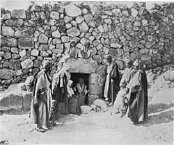
Other sites

[edit]

The oldest house in present-day al-Eizariya, a 2,000-year-old dwelling reputed to have been (or which at least serves as a reminder of) the House of Martha and Mary, is also a popular pilgrimage site.[13]

The house of Simon the Leper, which is known by locals as the Tower of Lazarus, is maintained by the Greek Orthodox Church.[13]

In 2014, a new mosque, the second largest in the wider-Jerusalem area, was opened, having been funded by the charitable foundation of named Sheikh Khalifa bin Zayed Al Nahyan, President of the United Arab Emirates.[70][71]

Bethany and care of the poor and sick

[edit]

Capper and others have concluded that ancient Bethany was the site of an almshouse for the poor and a place of care for the sick. There is a hint of association between Bethany and care for the unwell in the Gospels: Mark tells of Simon the Leper's house there (Mark 14:3–10); Jesus receives urgent word of Lazarus' illness from Bethany (John 11:1–12:11).

According to the Temple Scroll[where?] from Qumran, three places for the care of the sick, including one for lepers, are to be east of Jerusalem. The passage also defines a (minimum) radius of three thousand cubits (circa 1,800 yards) around the city within which nothing unclean shall be seen (XLVI:13–18). Since Bethany was, according to John, fifteen stadia (about 1.72 miles) from the holy city,[72] care for the sick there corresponded with the requirements of the Temple Scroll (the stadion being ideally 600 feet (180 m) or 400 cubits).[73] Whereas Bethphage is probably to be identified with At-Tur, on the peak of the Mount of Olives with a magnificent view of Jerusalem, Bethany lay below to the southeast, out of view of the Temple Mount, which may have made its location suitable as a place for care of the sick, "out of view" of the Temple.

From this it is possible to deduce that the mention of Simon the Leper at Bethany in Mark's Gospel suggests that the Essenes, or pious patrons from Jerusalem who held to a closely similar view of ideal arrangements, settled lepers at Bethany. Such influence on the planning of Jerusalem and its environs (and even its Temple) may have been possible especially during the reign of Herod the Great (36–4 BC), whose favour towards the Essenes was noted by Josephus (Antiquities 15.10.5 [373–78]).[74]

Reta Halteman Finger approves Capper's judgment that only in the context of an almshouse at Bethany, where the poor were received and assisted, could Jesus remark that "The poor you will always have with you" (Mark 14:7; Matthew 26:11) without sounding callous.[75] Ling follows Capper's thesis concerning the connection between then place-name Bethany and the location there of an almshouse. Capper and Ling note that it is only in Bethany we find mention of the poor on the lips of the disciples, who object that the expensive perfumed oil poured over Jesus there might have been sold and the proceeds given to the poor (Mark 14:5; Matthew 26:8–9; John 12:4–6 [where the objection is made by Judas]); this objection may have been made in embarrassment and may also suggest a special connection between Bethany and care for the poor.[76]

It has also been suggested, based on the names found carved on thousands of ossuaries at the site, that Bethany in the time of Jesus was settled by people from Galilee who had come to live by Jerusalem. This would explain why Jesus and the disciples, as Galileans, would find it convenient to stay here when visiting Jerusalem.[77] As Capper writes,

Galilean pilgrims avoided potential conflict with Samaritans by travelling south on the eastern side of the Jordan. Bethany was the last station on their route to Jerusalem after crossing the river and taking the road through Jericho up into the highlands. A respectful distance from the city and Temple, and on the pilgrim route, Bethany was a most suitable location for a charitable institution. It is not surprising that an Essene hospice had been established at Bethany to intercept and care for pilgrims at the end of the long and potentially arduous journey from Galilee. The house combined this work with care for the sick and destitute of the Jerusalem area. Thus Bethany received its name because it was the Essene poorhouse par excellence, the poorhouse which alleviated poverty closest to the holy city.[78]

Notable residents

[edit]

References

[edit]

Bibliography

[edit]
[edit]
Revisions and contributorsEdit on WikipediaRead on Wikipedia
from Grokipedia
Bethany, known in Arabic as al-Eizariya, is a Palestinian village situated on the southeastern slope of the Mount of Olives, about 3 kilometers east of Jerusalem in the Jerusalem Governorate.[1] In the New Testament, it is depicted as the residence of Lazarus, Mary, and Martha, and the location where Jesus raised Lazarus from the dead after four days in the tomb, an event described in the Gospel of John (John 11:1–44).[2] The village served as a frequent lodging place for Jesus during his final week in Jerusalem, including stays at the home of Simon the leper, where Mary anointed Jesus' feet with expensive perfume (John 12:1–8; Mark 14:3–9).[2] Archaeological investigations, including excavations conducted between 1949 and 1953, have uncovered rock-cut tombs dating to the First Temple period and layers of Byzantine and Crusader churches built over the traditional site of Lazarus' tomb, indicating early and sustained Christian pilgrimage and veneration from at least the fourth century AD.[1] These findings support the historical continuity of the site's identification with biblical Bethany, though the miracle itself remains a matter of faith rather than empirical verification.[3] In modern times, al-Eizariya has a population of approximately 21,000 residents, predominantly Palestinian Arabs, and is separated from Jerusalem by the Israeli separation barrier constructed in 2002, which has altered access routes to the area.[4][1] The village maintains religious significance with sites such as the Tomb of Lazarus and the Church of St. Lazarus, attracting pilgrims despite geopolitical constraints.[1]

Geography and Location

Physical Setting and Borders

Al-Eizariya occupies the southeastern slopes of the Mount of Olives, positioned approximately 2 kilometers east of Jerusalem's Old City walls.[5] The terrain consists of rocky, terraced hills characteristic of the Judean highlands, with olive groves dotting the landscape alongside expanding urban built-up areas.[6] The average elevation is 618 meters above sea level.[6] To the west, Al-Eizariya adjoins East Jerusalem, while its eastern and southern extents align with adjacent Palestinian localities such as Abu Dis.[7] The Israeli separation barrier, construction of which commenced in 2002, traverses or borders sections of the town, segmenting access and enclosing certain residential pockets.[8][7] This barrier delineates a de facto boundary that isolates parts of Al-Eizariya from contiguous areas.[9]

Proximity to Jerusalem and Regional Context

Bethany, identified with the modern village of Al-Eizariya, lies approximately 3 kilometers east of Jerusalem on the southeastern slopes of the Mount of Olives. Biblically, it is described as being about 15 stadia—roughly 2.8 kilometers—from the city, a distance that positioned it within a Sabbath day's journey and facilitated frequent interactions between the village and Jerusalem.[2][10] This proximity historically integrated Bethany into ancient pilgrimage and trade routes ascending from Jericho through the Judean Desert, serving as a key waypoint for travelers en route to Jerusalem from the Jordan Valley and Dead Sea areas.[11][12] In the regional context, Bethany's location at the interface of Jerusalem's urban environs and the arid Judean Desert influenced early settlement patterns by providing access to fertile slopes while bordering expansive wilderness tracts that shaped overland commerce and migration. The village overlooks the descent toward the Dead Sea, approximately 25 kilometers further east, underscoring its role in connecting highland agricultural zones with lowland saline resources and trade paths.[13][14] Administratively, Al-Eizariya falls within the Jerusalem Governorate under Palestinian Authority jurisdiction, yet its adjacency to Israeli-controlled East Jerusalem—established after the 1967 Six-Day War—has shaped contemporary access dynamics. Direct connectivity relies on local roads intersecting Highway 1, the primary route from Jerusalem eastward to Jericho and the Jordan Valley, though the Israeli separation barrier, constructed in the early 2000s, creates enclaves and checkpoints that constrain movement between the village and the capital.[15][8]

Etymology and Identification

Historical and Linguistic Origins

The name Bethany derives from the Aramaic beth ʿanya (בית עניא), signifying "house of affliction" or "house of the poor," where beth means "house" and ʿanya denotes poverty, misery, or affliction, consistent with Semitic linguistic patterns in the Judean region during the 1st century CE.[16] [17] Alternative interpretations link the second element to ʿanah (to answer or afflict) or even to terms for unripe figs or dates, though scholarly consensus favors the connotation of hardship.[17] This etymology aligns with the village's portrayal in ancient texts as a modest settlement near Jerusalem. In the Greek New Testament, the name appears as Βηθανία (Bethania), a transliteration of the Aramaic form, used in passages such as John 11:1 and Mark 11:1 to denote the site of key events involving Jesus.[18] Early patristic sources preserved this rendering; Eusebius of Caesarea, in his Onomasticon (ca. 325 CE), glosses it in Latin as domus adflictionis ("house of affliction"), drawing directly from Hebrew-Aramaic roots to affirm textual continuity from biblical-era usage without alteration in core meaning.[19] The Arabic toponym Al-ʿĪzāriyya (العِزَرِيَّة), meaning "place of Lazarus" or "of ʿAzār" (the Arabic form of the biblical Lazarus), emerged in the Islamic period but stems from a Christian tradition of associating the site with the raising of Lazarus (John 11), attested in pilgrimage accounts from the 4th century CE onward.[5] This shift prioritizes the narrative figure over the original Semitic etymology, illustrating how religious commemoration influenced linguistic adaptation while maintaining site identification.

Debates on Biblical Location

The identification of biblical Bethany, the village associated with Lazarus in the Gospel of John (John 11:1), with the modern site of Al-Eizariya has been traditional since the third century CE, when Origen located it approximately two Roman miles (about 3 kilometers) east of Jerusalem, aligning with the textual specification in John 11:18 of "about fifteen stadia" from the city.[20] This proximity criterion, derived from direct biblical measurement rather than later ecclesiastical tradition, positions Al-Eizariya as the primary candidate, as alternative sites farther afield fail to match the geographic constraint without textual emendation. Origen's assessment, informed by his travels in Palestine, prioritized scriptural fidelity over speculative relocation, establishing a baseline for subsequent identifications grounded in empirical distance verification.[21] Archaeological excavations at Al-Eizariya provide correlative support through discoveries of Second Temple-period (first century BCE to first century CE) rock-cut tombs and ossuaries consistent with Jewish burial customs of the era, including loculi for bone repositories and rolling stones, indicating continuous habitation compatible with a village setting during Jesus' time.[1] These finds, layered across Iron Age through Byzantine strata, affirm settlement density without contradicting the Gospel's portrayal of a modest Judean village, though no inscriptions explicitly naming "Bethany" have surfaced, leaving room for interpretive linkage rather than definitive proof. Proponents argue this material evidence outweighs reliance on post-biblical pilgrimage lore, as the site's topography—on the eastern slope of the Mount of Olives facing the Judean Desert—facilitates the biblical events' logistical feasibility, such as rapid travel to Jerusalem.[22] Challenges to this identification arise from minority scholarly proposals relocating Bethany higher on the Mount of Olives, nearer Bethphage, based on interpretations of Gospel itineraries suggesting a site more integrated with processional routes (e.g., the Triumphal Entry in John 12:1).[23] Italian scholar Zanecchia in 1899 advocated this upward shift, citing potential discrepancies in descent descriptions, but such views lack corresponding first-century artifacts and contradict the fixed distance in John 11:18, rendering them empirically weaker. Distinct from Lazarus' Bethany, the "Bethany beyond the Jordan" in John 1:28—site of John the Baptist's ministry—has been erroneously conflated in some analyses, with Origen proposing Bethabara as an alternative reading, yet excavations there yield no evidence of the former's village context, reinforcing the separation via textual and geographic distinctives.[24] Overall, the consensus favors Al-Eizariya due to convergence of textual metrics and archaeological habitation traces, dismissing alternatives for insufficient causal alignment with primary sources.

Biblical and Religious Significance

Key Events in the New Testament

In the Gospel of John, Bethany is described as the village of Mary and her sister Martha, along with their brother Lazarus, located about two miles from Jerusalem.[25] The narrative recounts Lazarus falling ill, with his sisters sending word to Jesus, who delays his arrival until after Lazarus has died and been buried in a nearby tomb for four days.[26] Upon reaching Bethany, Jesus speaks with Martha about resurrection and life, then calls Lazarus out of the tomb, commanding the burial cloths to be removed after the stone is rolled away. This event prompts many witnesses from the local Jewish community to believe in Jesus, while others report it to the Pharisees.[25] Six days before the Passover, the same Gospel places Jesus in Bethany for a supper at the home of Simon the Leper, where Lazarus reclines at the table.[27] During the meal, Mary takes a pound of costly pure nard ointment, anoints Jesus' feet, and wipes them with her hair, filling the house with the fragrance.[28] Judas Iscariot objects, claiming the perfume—valued at about a year's wages—could have been sold for the poor, though the text attributes his motive to theft from the moneybag he carried. Jesus defends the act, stating it anticipates his burial and that the poor will always be present, but he will not. The Synoptic Gospels position Bethany as the starting point for Jesus' entry into Jerusalem. In Mark, as Jesus approaches the city from Bethphage and Bethany at the Mount of Olives, he instructs two disciples to enter the opposite village and untie a colt never ridden, which the owner releases upon mention of the Lord needing it.[29] Jesus rides the colt into Jerusalem amid crowds spreading cloaks and branches, shouting "Hosanna; Blessed is he that cometh in the name of the Lord," fulfilling Zechariah's prophecy of a king entering humbly on a donkey. Luke and Matthew provide parallel accounts, specifying the location near Bethphage and Bethany at the Mount of Olives' base, with the colt's arrival enabling the procession.[30] After entering the temple and looking around, Jesus returns to Bethany for the night.

Theological and Symbolic Role

In Christian theology, Bethany near Jerusalem serves as the setting for the raising of Lazarus, an event that underscores Jesus' declaration, "I am the resurrection and the life," affirming his authority over death as a present reality for believers (John 11:25). This miracle, recounted in John 11:1–44, exemplifies divine power transcending natural decay, with Lazarus having been dead four days, emphasizing the empirical claim of restoration beyond mere resuscitation. Martha's confession immediately preceding the event—"Yes, Lord; I believe that you are the Christ, the Son of God, he who is coming into the world" (John 11:27)—represents a pivotal christological affirmation, paralleling Peter's declaration in Matthew 16:16 and highlighting faith amid grief as essential to recognizing Jesus' messianic identity. This interaction illustrates themes of doubt resolved through revelation, where human sorrow confronts eternal hope grounded in Jesus' person rather than eschatological expectation alone. Theologically, the Lazarus narrative prefigures Christ's own resurrection, portraying it as a harbinger of Easter's ultimate victory over death and validating the doctrine of bodily resurrection for the righteous. By restoring Lazarus, Jesus not only demonstrates causal efficacy against mortality but also intensifies opposition leading to his crucifixion, linking the event to redemptive purpose (John 11:45–53). Early Christian interpretation viewed this as historical testimony to miracles as evidentiary foundations for doctrine, influencing creedal statements on resurrection without reliance on allegorical overreach. Unlike symbolic baptisms elsewhere, Bethany symbolizes consummation of life from death, reinforcing eternal life as immediate inheritance for believers rather than deferred abstraction. This contrasts with "Bethany beyond the Jordan" (John 1:28), associated with John the Baptist's ministry and symbolizing initiation through water and repentance, marking the onset of Jesus' public work. The near-Jerusalem Bethany, by evoking finality in raising the dead, underscores culmination—faith perfected in the face of tomb-sealed finality—while the trans-Jordan site evokes beginnings and purification. Such distinctions highlight scriptural progression from preparatory symbolism to demonstrative power, informing patristic emphasis on miracles as historical pivots in soteriology.

Identification with Al-Eizariya

The identification of biblical Bethany with Al-Eizariya is supported by an unbroken tradition of Christian pilgrimage beginning in the early centuries AD. The pilgrim Egeria, writing in the late 4th century, documented her visit to the site of Lazarus's tomb and related Gospel events, placing Bethany fifteen stadia (approximately 2.8 kilometers) from Jerusalem on the eastern slopes of the Mount of Olives, a location that corresponds exactly to Al-Eizariya's topography and distance along the road to Jericho.[22] This early attestation aligns with the site's continuous veneration, including the construction of churches over presumed biblical locations by the Byzantine period. The Arabic name Al-Eizariya, meaning "place of Lazarus," derives directly from the New Testament figure raised by Jesus, preserving the memory of John 11's events through local nomenclature unchanged since at least the medieval era.[1] This linguistic continuity reinforces the tradition, as the village has maintained its association with Bethany without interruption in historical records from pilgrims and travelers. Archaeological traces at Al-Eizariya include rock-cut tombs and settlement remnants datable to the 1st century AD, confirming its occupation as a Jewish village during Jesus's time, consistent with Gospel descriptions of a modest community near Jerusalem.[1] No alternative sites in the immediate vicinity exhibit comparable 1st-century Jewish village evidence combined with such enduring pilgrimage tradition. The site's proximity to Jerusalem—roughly 3 kilometers—practically enables the frequent, short-distance movements depicted in the Gospels, such as Jesus's overnight stays in Bethany followed by daily entries into the city (John 12:1), which would have been feasible on foot but implausible from more remote locations.[1]

Historical Overview

Ancient and Biblical-Era Settlement

Archaeological surveys at Al-Eizariya, identified with ancient Bethany, have uncovered tombs dating to the Bronze Age (c. 3000–1200 BCE), indicating early funerary use of the site on the eastern slopes of the Mount of Olives.[5] Pottery fragments from the Persian period (539–332 BCE) further attest to sporadic habitation or activity, bridging to later eras amid regional continuity near Jerusalem.[5][1] Hellenistic-era (c. 332–63 BCE) pottery, including collared-rim vessels typical of the period, has been documented in excavations, signaling settlement expansion consistent with Judean village patterns proximate to Jerusalem's urban growth.[31] These findings, alongside regional Iron Age inferences from Jerusalem's pottery assemblages, suggest Bethany's incorporation into broader Judean networks by the late First Temple period, though direct Iron Age strata remain limited.[32] By the 1st century CE, during the Second Temple period, Bethany functioned as a Jewish village, evidenced by rock-cut tombs reflecting kokhim-style burials standard in Jewish practice, a Second Temple cistern, and remains of houses, wine presses, silos, and additional cisterns.[33][1][34] The site's cemetery north of the traditional Lazarus tomb area confirms 1st-century CE activity, with structures aligning temporally to support a modest agrarian community approximately 3 kilometers from Jerusalem.[1] No archaeological discontinuities contradict the village's existence in this era, as layered artifacts indicate stable pre-70 CE occupation.[1][34] Historical records from Flavius Josephus describe Roman forces under Titus utilizing Bethany as a strategic base during the 70 CE siege of Jerusalem, implying it avoided the immediate wholesale destruction inflicted on the capital, though surrounding Judean sites exhibit burn layers and disruption from the campaign.[35] Artifact distributions, including Roman-period overlays on earlier strata, reflect this transition without evidencing total abandonment.[1]

Byzantine and Early Medieval Periods

During the fourth century CE, following the Edict of Milan in 313 CE, Bethany emerged as a significant Christian pilgrimage site associated with the resurrection of Lazarus, leading to the construction of the Lazarion complex, which included a church over the traditional tomb and adjacent monastic structures.[22] The pilgrim Egeria, documenting her journey around 381–384 CE, described visiting Bethany, where she participated in services at the Church of Lazarus, noting the site's veneration through processions, hymns, and the viewing of the tomb, which reinforced its continuity as a locus of empirical Christian tradition tied to New Testament events.[36] Archaeological layers confirm Byzantine-era building activity, including basilical churches with apses and associated chapels, indicating organized ecclesiastical investment in preserving the site's historical and symbolic role. The Sasanian Persian conquest of Jerusalem in 614 CE disrupted regional Christian sites, with historical accounts reporting violence and the desecration of relics, though archaeological assessments reveal limited structural destruction in peripheral areas like Bethany compared to the capital, where mass graves attest to casualties but not wholesale ruin of churches.[37] Byzantine forces under Heraclius reconquered the area by 629 CE, temporarily restoring control, but the site experienced further upheaval during the Arab Muslim conquest of Palestine, culminating in the surrender of Jerusalem to Caliph Umar in 638 CE.[38] Despite these invasions, evidence from stratigraphy shows no immediate abandonment of the Lazarion; the church remained in use into the early Islamic period, with mosaics and inscriptions—such as those referencing Lazarus—affirming the persistence of pre-conquest traditions amid gradual sociopolitical shifts.[22] This era underscores causal continuity in site veneration, as pilgrim traffic and monastic presence empirically sustained Bethany's identity, evidenced by durable architectural remnants and textual records, rather than abrupt cessation following conquests.[39]

Islamic, Crusader, and Mamluk Eras

Following the Muslim conquest of Jerusalem in 636 CE, al-Eizariya (Bethany) transitioned under Islamic administration, with the tomb of Lazarus—known in Arabic as al-Uzair—retaining veneration among Muslims as a site associated with a pious figure from prophetic traditions.[40] Existing Byzantine-era churches and structures saw repurposing for Muslim use, but the Umayyad (661–750 CE) and Abbasid (750–969 CE) periods featured minimal new construction, preserving the site's role as a modest pilgrimage destination amid a shift to Muslim-majority inhabitation.[41] The First Crusade's capture of Jerusalem in 1099 CE brought al-Eizariya under Latin Christian control, where it was referred to by its biblical name, Bethany. In 1138, King Fulk of Anjou and Queen Melisende acquired the village from the Latin Patriarchate, commissioning renovations to the church overlying the tomb and constructing a Benedictine nunnery nearby to support pilgrimage.[42] These efforts restored facilities damaged or neglected under prior Fatimid rule, emphasizing the site's scriptural significance.[43] Saladin's forces recaptured the area in 1187 CE following the Battle of Hattin, promptly converting the Crusader church into a mosque while allowing limited Christian access.[42] Under subsequent Ayyubid oversight, the site stabilized as a Muslim endowment. In the Mamluk Sultanate (1260–1517 CE), al-Eizariya received modest enhancements, including the construction of the small al-Uzair Mosque in 1384 CE adjacent to the tomb, reflecting ongoing Islamic patronage.[5] The village functioned as a charitable outpost for aiding the poor and ill, supported by waqf foundations typical of Mamluk urban-rural networks, though no major fortifications are recorded specific to the locality.[5]

Ottoman, British Mandate, and Jordanian Periods

During the Ottoman period (1517–1917), al-Eizariya remained a small Palestinian Arab village centered around agricultural activities and the al-Uzair Mosque, which was expanded in the 16th century to accommodate the predominantly Muslim population and named in honor of Lazarus.[1] In the late 19th century, European explorers documented the village's modest scale, with estimates of around 113 inhabitants and 36 houses circa 1870.[1] The Franciscan Custody of the Holy Land acquired a plot near the Tomb of Lazarus in 1863, facilitating renewed Christian stewardship over associated religious traditions despite the site's secondary status under Ottoman administration.[1] Under the British Mandate (1917–1948), al-Eizariya experienced population growth amid improved infrastructure and regional stability, rising from 515 residents (506 Muslims and 9 Christians) in the 1922 census to 726 in 1931 and 1,060 (1,040 Muslims and 20 Christians) by 1945, according to official Mandate village statistics.[44] This era saw heightened Christian pilgrimage to the Tomb of Lazarus, supported by British facilitation of access to holy sites and Franciscan efforts to maintain the location's spiritual significance.[42] The 1948 Arab-Israeli War positioned the village on the Jordanian side of the armistice line, immediately adjacent to Israeli-controlled territory, disrupting prior cross-boundary movements.[41] From 1948 to 1967, under Jordanian annexation of the West Bank, al-Eizariya's population expanded to 3,308 by 1961, reflecting broader demographic shifts and limited economic development in the area.[45] Jordanian policies emphasized Arab cultural integration, with the village functioning as a predominantly Muslim community while Franciscans constructed a new church (1952–1955, consecrated 1954) over remnants of Byzantine and Crusader-era structures to commemorate the house of Mary, Martha, and the resurrection of Lazarus.[42] Access to the site remained restricted for Israeli citizens and Jews, consistent with Jordan's effective prohibition on their entry to annexed territories, though Christian pilgrims from other regions could visit under regulated conditions.[46]

Post-1967 Israeli Administration and Palestinian Authority

Following Israel's victory in the Six-Day War from June 5 to 10, 1967, military forces captured Al-Eizariya from Jordanian control, placing the village under Israeli administration as part of the occupied West Bank.[41] Eastern agricultural lands were designated a closed military zone, limiting Palestinian farming access and contributing to rising local tensions over land use, while pilgrimage to sites like the Tomb of Lazarus remained permissible under regulated entry.[47] The Oslo Accords of 1993, implemented via Oslo II in September 1995, partitioned the West Bank into Areas A, B, and C for interim governance, with Al-Eizariya spanning primarily Areas B (Palestinian civil control with shared security) and C (full Israeli control). The Palestinian Authority (PA), established in 1994, assumed civil administrative responsibilities in Area B sections, enabling municipal council operations and infrastructure development; this autonomy coincided with population growth from about 12,000 residents in the mid-1990s to 16,500 by 2007 and over 20,000 by 2017, fueled by high birth rates and proximity to East Jerusalem labor markets.[4] The First Intifada (December 1987–September 1993) and Second Intifada (September 2000–February 2005) imposed severe constraints through intensified Israeli checkpoints and military operations, curtailing movement and slashing tourism to Bethany's religious landmarks by up to 80% during peak violence periods, which eroded local economies reliant on pilgrims.[48] PA governance post-Oslo mitigated some disruptions by coordinating local services, though ongoing security coordination with Israel limited full autonomy and sustained economic volatility.[49]

Archaeology and Material Evidence

Major Excavation Sites

Franciscan archaeologists, under the Custodia di Terra Santa, initiated excavations around the Tomb of Lazarus and the associated sanctuary following the acquisition of the site in 1894, with major systematic digs conducted by Fr. Sylvester J. Saller from 1949 to 1953. These efforts focused on the church complex overlying the tomb, revealing stratified remains including Byzantine-era structures and earlier rock-cut features.[50][51] In the same vicinity, ongoing archaeological work by the Studium Biblicum Franciscanum and Custodia di Terra Santa has continued into the 21st century, including surveys and limited probes around the Franciscan shrine as of 2024, aimed at clarifying the site's occupational layers tied to early Christian veneration.[52] Separate excavations since 2016, led by Pro Terra Sancta in collaboration with local Palestinian groups like the Mosaic Center, target the purported house of Lazarus, Mary, and Martha in Al-Eizariya, emphasizing conservation of exposed walls and potential 1st-century domestic features amid funding and access limitations under Palestinian Authority oversight.[53] Pre-1990s surveys by the Israel Antiquities Authority in adjacent eastern Jerusalem slopes documented scattered 1st-century CE rock-cut tombs near Al-Eizariya, though full-scale digs within Bethany proper remained constrained by jurisdictional shifts post-1967.[54]

Key Findings Supporting Biblical Accounts

Archaeological excavations in Al-Eizariya, identified as ancient Bethany, have revealed rock-cut tombs dating to the 1st century CE, particularly north of the traditional site associated with Lazarus, indicating active Jewish burial practices during the period described in the Gospels.[1] These tombs align with Second Temple-era customs, including secondary burial in loculi, consistent with a populated Jewish village approximately 2 miles (3 km) east of Jerusalem as referenced in John 11:18.[1] Pottery fragments recovered from cisterns and stratified deposits during 1949–1953 excavations led by Sylvester J. Saller attest to Roman-period occupation, featuring forms typical of the Herodian and early Roman eras, such as ribbed jars and cooking pots, which match assemblages from Judean sites contemporaneous with Gospel narratives.[55] These findings counter claims of sparse or absent settlement by demonstrating material continuity from the Hellenistic through 1st-century CE layers, without discontinuities or intrusive later artifacts that would undermine the site's historicity.[1] Byzantine strata overlying earlier remains include foundations of churches and pilgrimage structures from the 4th to 6th centuries CE, evidencing veneration of the location as the biblical Bethany shortly after the apostolic era, as documented in early Christian pilgrim accounts like those of Egeria around 381–384 CE.[1] Ossuaries from 1st-century contexts in the vicinity bear inscriptions with names like Eleazar (Greek: Lazaros), reflecting demographic patterns of Jewish onomastics in the region and supporting the plausibility of figures such as Lazarus of Bethany.[56] This empirical layering—spanning six occupational phases—affirms a persistent settlement pattern amenable to the scriptural portrayal of Bethany as a familial and communal hub.[1]

Challenges and Political Influences on Research

Archaeological investigations at Bethany (Al-Eizariya) encounter substantial barriers stemming from international academic boycotts directed at Israeli excavations in Judea and Samaria, regions encompassing the site. Since the 1990s, these boycotts have intensified, effectively silencing research that corroborates biblical historical accounts by restricting publications and collaborations. For example, in 2025, the chief editor of a prominent archaeology journal confirmed a policy blacklisting submissions from Israeli researchers on Judea and Samaria unless they incorporate cooperation with Palestinian authorities, thereby limiting dissemination of empirical findings from sites like Bethany.[57][58] Palestinian Authority (PA) oversight in adjacent areas further constrains joint Israeli-Palestinian projects, with administrative control and funding allocations favoring interpretations that de-emphasize biblical-era Jewish continuity. Under the Oslo II Accord of 1995, Israel retains authority over antiquities in much of the West Bank, including over 4,500 sites, yet PA initiatives have included attempts to alter or obscure heritage loci, such as paving over biblical remnants, which impedes systematic excavation at peripherally influenced locations like Bethany.[59][60] PA-linked neglect or looting affects hundreds of West Bank sites annually, skewing resources away from data-preserving efforts toward politically aligned narratives.[61][62] These challenges reflect deeper ideological pressures in academia, where empirical evidence supporting biblical realism often yields to contemporary political priorities, including skepticism of ancient Israelite presence derived from non-verifiable minimalist paradigms. Mainstream scholarly institutions, exhibiting systemic biases toward revisionist histories, underfund or marginalize pro-biblical archaeology, as evidenced by widespread academic disregard for accumulating material confirmations despite their volume.[63] This prioritization of ideological conformity over causal analysis of artifacts hampers objective research, particularly for sites tied to New Testament events like the raising of Lazarus, privileging modern geopolitical narratives over stratigraphic and inscriptional data.[64]

Religious and Cultural Landmarks

Tomb of Lazarus and Associated Traditions

The Tomb of Lazarus consists of a rock-cut cave located in al-Eizariya, traditionally identified as biblical Bethany, featuring a 1st-century antechamber and burial chamber accessed by a narrow descending passageway and 24 steps.[65] Archaeological evidence confirms the surrounding area served as a Jewish cemetery during the 1st century AD, with comparable rock-cut tombs excavated nearby, aligning topographically with the Gospel of John's description of Lazarus's entombment near the village.[1] However, no inscriptions or artifacts directly link the specific cave to Lazarus, rendering claims of its precise authenticity unprovable through empirical means alone, though the site's continuity as a burial locale supports its plausibility within the era's necropolis.[66] Byzantine-era modifications included the addition of a chapel over the tomb entrance around the 4th-5th centuries, reflecting early Christian veneration tied to the tradition of Lazarus's four-day entombment before resurrection, as recounted in John 11.[67] This structure was rebuilt multiple times, with Franciscan custodians maintaining access until the 16th century, when Ottoman authorities constructed the adjacent al-Uzair Mosque to honor Lazarus (known as Uzair in Islamic tradition) as a prophet, incorporating elements of the site into Muslim reverence.[1] The shared sanctity persists, as the tomb draws pilgrims from both faiths, though physical evidence for the miracle remains absent, with authenticity resting on unbroken tradition rather than archaeological corroboration.[40]

Churches, Mosques, and Other Structures

The Church of Saint Lazarus, a Roman Catholic structure managed by the Franciscans, stands on the site of earlier Byzantine and Crusader edifices dating to the 4th and 12th centuries, respectively; the current building was constructed between 1952 and 1955 by architect Antonio Barluzzi atop these remnants following Franciscan acquisition of the property in 1894.[65][1] The church features a design incorporating archaeological layers visible in its courtyard, including mosaic floors from prior phases.[1] Adjacent to this site, the al-Uzair Mosque originated as a small structure built in 1384 during the Mamluk period and was later expanded by the Ottomans in the 16th century to serve the Muslim population; it underwent renovation in 2001 and lies near the Greek Orthodox church in al-Eizariya.[5][68] Remnants of Crusader-era walls and foundations persist beneath and around the modern Church of Saint Lazarus, preserved amid ongoing archaeological efforts by Franciscan custodians despite pressures from contemporary urban development in the densely populated town.[1][52] The Franciscan complex includes monastic elements tied to the church's maintenance since the late 19th century, though no distinct 17th-century monastery structure is documented separately.[69]

Role in Christian Pilgrimage and Local Traditions

Bethany functions as a key destination for Christian pilgrims seeking to connect with the biblical account of Lazarus's resurrection in the Gospel of John, chapter 11, where Jesus raises his friend after four days in the tomb. The site's religious significance draws Eastern Orthodox visitors particularly during the liturgical season leading to Easter, with the Tomb of Lazarus serving as the primary focal point for veneration and prayer. Annual observances maintain historical continuity, linking the miracle to the anticipation of Christ's own Resurrection and integrating Bethany into the Paschal narrative observed across Orthodox traditions.[70] Lazarus Saturday, the feast day immediately before Palm Sunday on the Orthodox calendar, features centralized celebrations in Bethany coordinated by the Greek Orthodox Patriarchate of Jerusalem. These include Divine Liturgies and processions involving local clergy, monastic communities, and pilgrims, often centered at St. Lazarus Greek Orthodox Church and the adjacent monastery of Martha and Mary. For instance, on April 24, 2021, services commemorated the resurrection at these venues, with participants gathering to honor the event's theological implications for victory over death. Similar rites occurred on April 8, 2017, and April 27, 2024, underscoring the feast's role in communal worship and its procession from monastic sites to the tomb area.[71][72][73] Local traditions in al-Eizariya blend devotion to Lazarus across Christian practices, with processions like the 2019 event from the Holy Monastery of Martha and Mary reinforcing ties to the biblical locale through ritual movement and hymnody. These customs emphasize Lazarus as a symbol of hope and divine power, observed by Arab Christian residents who maintain the sites' upkeep and participate actively. While primarily Orthodox, the veneration extends interfaith dimensions, as Lazarus—known as al-Uzair in Arabic—is acknowledged in Islamic tradition as a figure associated with Jesus's miracles, reflected in the naming of the local al-Uzair Mosque after him, though Christian rituals remain distinct.[74][75] Pilgrimage to Bethany has demonstrated continuity into the 21st century, with documented annual events persisting amid regional challenges, as evidenced by Patriarchate-led commemorations from 2016 onward. This resurgence in organized visits during stable liturgical periods highlights the site's enduring draw for those tracing early Christian history, though participation numbers fluctuate based on accessibility.[71][75]

Modern Demographics and Society

Population Composition and Economy

As of the 2017 Palestinian census, Al-Eizariya recorded a population of 20,978 residents, with Palestinian Central Bureau of Statistics (PCBS) projections indicating growth to approximately 30,000 by the mid-2020s due to natural increase and migration patterns in the Jerusalem Governorate.[4] The demographic composition consists primarily of Palestinian Arabs, overwhelmingly Sunni Muslims, with a small Christian minority comprising less than 1% of the population, consistent with the broader decline of Christian communities in the West Bank.[4] The local economy centers on service-oriented activities, particularly tourism drawn to religious landmarks like the Tomb of Lazarus, alongside limited agriculture focused on olive production and stone quarrying.[76] A significant portion of employment involves daily labor commuting to Jerusalem and Israeli settlements, though Israeli security measures, including checkpoints and the separation barrier, have curtailed access and contributed to economic stagnation since the early 2000s.[8] Unemployment in Al-Eizariya mirrors West Bank trends, with the overall rate rising to 31% in 2024 amid reduced work permits in Israel and conflict-related disruptions, exacerbating high youth unemployment estimated at over 40% regionally.[77] Urbanization has accelerated since the 1990s Oslo Accords, featuring informal housing expansions on available land to house growing families, though spatial constraints from the separation barrier limit further development.[78]

Social Services and Community Life

Bethany's historical role in social welfare traces to its Aramaic etymology, Beth Anyah, meaning "house of misery" or "house of the poor," indicating an early function as an almshouse and site for caring for the sick and needy.[79] Biblical narratives in the Gospel of John portray the village as a haven of hospitality, where Jesus received support from locals amid his ministry, including provisions for the poor referenced in John 12:8.[80] This tradition persisted through medieval periods, with pilgrim hospices extending aid to travelers and the destitute, evolving from biblical precedents of communal care. In modern Al-Eizariya, the Palestinian Authority manages primary social services, including education through public schools like Al-Eizariya Girls Basic School and health via the Al-Eizariya Health Care Directorate, which received funding in 2023 for facility expansion.[81][82] Specialized NGOs supplement these, such as House of Hope Vision School, a trauma-informed elementary institution serving around 75 students with holistic education incorporating art and music therapy.[83] Four Homes of Mercy operates a facility in Al-Eizariya providing long-term residential care and rehabilitation for 64 individuals with neurological impairments, including physical therapy and recreational programs.[84] Community life emphasizes family-based support networks, which bolster resilience against economic pressures, alongside charitable efforts like Zahra Home for Orphaned Girls, offering shelter and vocational training.[85] These structures foster mutual aid, with extended families often sharing resources for daily needs and child-rearing, reflecting enduring traditions of communal solidarity.[49]

Notable Residents and Figures

The primary figures historically associated with Bethany are the siblings Lazarus, Mary, and Martha, residents of the village during the first century CE. According to the Gospel of John, Lazarus was raised from the dead by Jesus after four days in a tomb, an event witnessed by his sisters and others, underscoring themes of resurrection and faith. Mary and Martha, who maintained a household in Bethany, hosted Jesus on multiple occasions; Martha is portrayed as actively serving while Mary listens attentively, prompting Jesus' teaching on priorities of devotion. These accounts position Bethany as a site of intimate friendship between Jesus and the family, with the siblings later venerated in Christian tradition as saints symbolizing hospitality and belief. Among modern residents of Al-Eizariya, Aziz Abu Sarah (born 1980) stands out as a peace activist and social entrepreneur. Raised in the village to a Muslim family, he co-founded Mejdi Tours, which conducts dual-narrative tours for Israelis and Palestinians to encourage mutual understanding through shared history and sites like Bethany.[86] His work extends to initiatives like InterAct International, promoting reconciliation amid conflict.[87] Another notable figure is Said K. Aburish (1935–2012), a journalist, author, and broadcaster born in Bethany to a prominent Palestinian family. He chronicled Arab political history in books such as Nasser: The Dark Side (2004) and Arafat: From Defender to Dictator (1998), drawing on his experiences as a Beirut-based correspondent for outlets like NBC and Al Jazeera.[88] Aburish's family relocated during the 1948 Arab-Israeli War, after which he pursued education at Princeton and Harvard, shaping his critical analyses of Middle Eastern leadership.[89] Beyond these, Bethany's residents have garnered limited international recognition, overshadowed by the locality's religious and geopolitical context.

Political Status and Controversies

Territorial Control and Security Barriers

Following the Oslo Accords, the Palestinian Authority established civil administration over Al-Eizariya (Bethany), managing local governance while Israel retained security oversight of borders and access routes. The Israeli separation barrier, initiated in 2002 amid the Second Intifada's wave of suicide bombings, was constructed through phases extending to 2005, routing around Jerusalem and enclaving portions of Al-Eizariya and adjacent areas like Abu Dis to separate them from East Jerusalem. Israeli authorities designed the barrier to impede terrorist infiltrations, citing its completion in northern sectors as correlating with sharp declines in successful attacks originating from those areas.[90] Checkpoints along the barrier, such as the Az-Za'ayyem crossing east of Al-Eizariya, regulate Palestinian movement to Jerusalem, imposing delays that studies quantify as causing annual time losses exceeding 50 million hours across West Bank checkpoints, contributing to economic constraints including reduced labor access and trade. Proponents argue these measures yielded net security benefits, with Israeli data indicating suicide bombings from the West Bank fell from over 130 incidents between 2000 and 2005 to near zero by 2008 following barrier expansion. Critics, including United Nations reports, highlight humanitarian costs, such as restricted medical access and agricultural land severance, though empirical attack reductions substantiate the barrier's defensive efficacy despite operational frictions.[91][92] The International Court of Justice's 2004 advisory opinion deemed the barrier illegal under international law due to its location in occupied territory and associated rights violations, urging dismantlement. Conversely, the Israeli High Court of Justice upheld the barrier's security rationale in 2004 rulings, mandating route adjustments where Palestinian harm outweighed proportional security gains but affirming construction where necessary to protect Israeli civilians from imminent threats. These divergent judicial assessments reflect tensions between global humanitarian norms and localized threat assessments grounded in post-Intifada violence patterns.[93][94]

Israeli and Palestinian Claims

Israeli officials and legal scholars argue that Bethany, biblically identified as Beit Anya in the heartland of ancient Judea, embodies enduring Jewish historical continuity, with archaeological and scriptural evidence linking it to Second Temple-era Jewish life and events described in the New Testament, such as the resurrection of Lazarus by Jesus, underscoring its role as cultural and religious heritage integral to Jewish national rights.[80] Israel contends that the broader Judea and Samaria region, including areas like Bethany, constitutes disputed rather than occupied territory, as no legitimate sovereign held title prior to 1967—Jordan's annexation being unrecognized internationally—and that legal rights stem from the 1920 San Remo Conference and 1922 League of Nations Mandate, which allocated the area for Jewish settlement and self-determination while preserving non-Jewish civil rights. Post-1967 administration is framed as lawful belligerent occupation under the 1907 Hague Regulations for defensive security needs following Jordan's initiation of hostilities, with Israel rejecting full applicability of the 1949 Fourth Geneva Convention's prohibition on civilian transfers, asserting no such forcible population movement occurred from Israel proper and that settlements serve historical reclamation rather than conquest.[95] Palestinian representatives maintain that al-Eizariya (Bethany) forms an inseparable part of Palestinian territory, with Arab communities demonstrating continuous indigenous presence through medieval Islamic records and Ottoman-era demographics, predating 20th-century Jewish immigration and entitling Palestinians to self-determination over the West Bank as a whole under post-World War I partition principles and UN General Assembly Resolution 181 (1947), which envisioned Arab statehood including Jerusalem's environs. They characterize Israel's 1967 capture as an belligerent occupation of Palestinian land in violation of international humanitarian law, demanding withdrawal to pre-1967 lines as affirmed by UN Security Council Resolution 242 (1967), with Bethany's governance by the Palestinian Authority reflecting rightful civil jurisdiction pending full sovereignty.[96] Neither side exercises undisputed formal sovereignty over Bethany, which falls under the Oslo Accords' interim framework—dividing the West Bank into Areas A, B, and C for shared or phased administration—explicitly deferring final-status issues like borders, settlements, and Jerusalem to bilateral negotiations, with the Palestinian Authority holding de facto civil control in Bethany while Israel retains overriding security authority.[97] Recent Israeli legislative motions, such as the July 2025 Knesset resolution endorsing sovereignty application to Judea and Samaria, signal aspirational claims but remain non-binding amid ongoing disputes.[98]

Impacts on Local Population and Access

The Israeli separation barrier, constructed primarily between 2002 and 2005, has significantly restricted movement for Al-Eizariya residents, enclosing the town in an enclave that limits direct access to East Jerusalem and requires passage through checkpoints like Al-Za'ayyem or Container for entry.[99] This has increased travel times for medical care, with residents often rerouted to facilities in Jericho or Ramallah, exacerbating hardships during emergencies.[49] However, Israeli authorities issue permits for work, medical treatment, and other essential access, with over 100,000 work permits granted annually to West Bank Palestinians, including those from areas near Jerusalem, enabling employment in Israel that provides higher wages than local opportunities.[100][101] Tourism to the Tomb of Lazarus and related sites, a key economic driver, peaked in the late 1990s with hundreds of thousands of annual visitors to Holy Land pilgrimage spots before the Second Intifada, but has since declined sharply due to ongoing security concerns and mobility restrictions, leading to job losses in guiding, hospitality, and commerce.[48] Post-barrier completion, terror attacks originating from the West Bank dropped by over 90% compared to 2000-2005 peaks, with suicide bombings falling from dozens annually to near zero, reducing local exposure to violence that previously deterred both residents and visitors.[102] Claims of barrier-induced isolation overlook parallel factors like Palestinian Authority governance issues, where 94% of West Bank residents perceive widespread corruption, diverting resources and stifling economic development independent of security measures.[103] The Christian minority in Al-Eizariya, comprising a shrinking share of the population amid a broader West Bank decline from about 2% to under 1% since the 1990s, has emigrated primarily due to chronic insecurity, harassment by Islamist groups, and economic stagnation rather than barriers alone, with surveys indicating persecution as the top driver for over 40% of departures.[104][105] While the barrier limits casual crossings, coordinated pilgrim access persists, and reduced incident rates post-2005 have stabilized some community activities compared to intifada-era chaos.[106]

References

User Avatar
No comments yet.