

Community hub
Recent from talks
Contribute something
Nothing was collected or created yet.
Tulkarm
View on Wikipedia32°18′45″N 35°1′36″E / 32.31250°N 35.02667°E
Tulkarm or Tulkarem (Arabic: طولكرم, Ṭūlkarm) is a city in the West Bank, Palestine and the capital of the Tulkarm Governorate. Netanya is to the west in Israel, while Nablus and Jenin are to the east. According to the Palestinian Central Bureau of Statistics, in 2017 Tulkarm had a population of 64,532.[1] Tulkarm is under the administration of the Palestinian National Authority.
Key Information


Etymology
[edit]The Arabic name translates as 'length of vinyard'[3] but is a distortion of the Aramaic name Tur Karma[4] ('mount of the vineyard'), which was used for Tulkarm by the Crusaders and by the mediaeval Samaritan inhabitants.[2][5]
History
[edit]During the Ayyubid era, after the Muslim reconquest of Palestine under Sultan Saladin in 1187, the first families to settle in Tulkarm were from the Kurdish clan of Zaydan.[6] A military group, the Zaydan were dispatched to the Wadi al-Sha'ir area, which includes Tulkarm, by Saladin to buttress the defense of the western approaches of Muslim-held Palestine from the Crusaders who dominated the coastal area.[6]
The Zaydan politically dominated Tulkarm and the vicinity until the early 17th century. Around 1230, during the late Ayyubid period, a group of Arabs from southern Palestine immigrated to Tulkarm. They had originally migrated to Palestine from Arabia many generations prior and had become semi-nomadic farmers and grazers.[6] Among the Arab families were the Fuqaha clan, who were considered ashraf (related to the Islamic prophet Muhammad) and served as the ulama (religious scholars) of the village.[6]
During the Ayyubid, and later the Mamluk era (1260–1517), the majority of Tulkarm's lands were made part of a waqf (religious trust) to support the al-Farisiyya Madrasa, an Islamic religious school in Jerusalem, located north of the Masjid Al-Aqsa compound. Two-thirds of the village's farmlands were confirmed as part of this trust in 1354 by the deputy-governor of Damascus, Faris al-Din al-Baki. During Mamluk rule another wave of Arab immigrants arrived in Tulkarm from North Africa and nearby Nablus. They largely engaged in agriculture and animal husbandry, supplying hides to leather merchants in the coastal villages, retaken from the Crusaders in the second half of the 13th century.[6]
Ottoman era
[edit]Tulkarm was incorporated into the Ottoman Empire in 1517. Afterward, Sultan Suleiman the Magnificent (r. 1520–66) transferred Tulkarm's waqf to the al-Jawhariyya Madrasa (Commons), located in the Muslim Quarter, northwest of the al-Aqsa Mosque. Under this arrangement, Tulkarm's inhabitants paid a third of their harvest as a tax towards the waqf, called qasm. At the time of the waqf's reassignment, the population of the village was estimated at 522 (95 households) and the qasm consisted of eight carats of wheat and three carats of barley. The town's elite families administered the trust, which enabled them to reach higher social and economic status. The population increased through intermarriage with families fleeing violent feuds between the various clans of Jabal Nablus. By 1548, the population had grown to 189 households or roughly 1,040 persons.[6]
Tulkarm appeared in Ottoman tax registers in 1596 as being in the nahiya (subdistrict) of Qaqun, which was a part of the sanjak (district) of Nablus. The largest village in the nahiya,[6] Tulkarm had a population of 176 Muslim households (roughly 968 persons) and paid taxes on wheat, barley, summer crops, olives, goats, beehives and a press for olives or grapes.[7] During this early period of Ottoman rule, there were five neighborhoods (pl. harat) centered around the Shaykh Ali al-Jazri al-Mughrabi Mosque, today referred to simply as the "Old Mosque". The population was overwhelmingly Sunni Muslim, and most residents were fellahin (peasants who worked the land.) The elite families during that time were the Zaydan and the Lajjun-based Tarabay, the latter belonging to the Bani Harith tribe. Because of the decentralized nature of the Ottoman state, these families and their successors in later centuries ruled the area with a high degree of autonomy. The Zaydan had particular authority over Tulkarm, being appointed as the mutassalim (tax collectors or enforcers) on behalf of the central authorities.[6]
In the mid-17th-century most members of the Zaydan family, with the exception of the children and the elderly, were killed in a massacre by Tulkarm's inhabitants during Friday prayers.[citation needed] This was in reaction to the Zaydan having forced Tulkarm's residents to harvest and process the village's grains for taxation purposes. Consequently, political power in Tulkarm passed to the Badran clan, while the Fuqaha family took control of administering the "waqf" lands, firmly establishing them as the village's religious leaders. The Fuqaha had derived much of their authority from their classification as ashraf and their association with the Sufi Rifa'iyya zawiya of the village. The western neighborhood was mostly emptied of Zaydan members and would serve as the main area of settlement for newcomers.[6]
Tulkarm appears on sheet 45 of Pierre Jacotin's map drawn up during Napoleon's invasion in 1799, named Toun Karin.[8][9]

Following the adoption of the Ottoman Land Code in 1858, the musha (collective landownership) system was gradually abrogated and residents were required to register their property with the central authorities. The fellahin were wary of registering their names for fear of military conscription by the Ottoman state and instead entrusted various elite clans with the role of landlords, who were in effect absentee owners. This altered the area's social structure, with the Samara, al-Hajj Ibrahim and Hanun clans legally obtaining vast swathes of Tulkarm's lands. Leadership of the town's two main religious establishments were generally supplied by the Kur-based Jayyusi clan and the al-Barqawi clan of Shufa.[6] The Barqawi clan controlled the area around the town in the 19th century.[10]
The 1860s French explorer Victor Guérin visited Tulkarm, which he described as being of "considerable" size, with about 1,000 inhabitants.[11] During this time, the Ottoman authorities granted the village an agricultural plot of land called Ghabat Tulkarm in the former confines of the Forest of Arsur (Ar. Al-Ghaba) in the coastal plain, west of the village.[12][13]

The Survey of Western Palestine in 1882 described Tulkarm as a "long straggling village, on high ground", surrounded by arable land and rock. There were several "good-sized" houses, mainly of stone in the village.[14]
Tulkarm became the administrative center of a new subdistrict (qada') Bani Saʿb-Tulkarm in 1876,[15] later becoming a municipality in 1892.[16] Tulkarm was also appointed a governor, bringing the residents who numbered only a few thousand and who were mostly fellahin, closer to the central government. This elevated status gave Tulkarm precedence over the nearby villages, which at that time also included Qalqilya. Tulkarm's center shifted from the Old Mosque to an empty space in the northwest as the town expanded northward with the construction of government buildings, a post office, a school and a hospital in that area.[17]
Around the turn of the 20th century, Tulkarm was one of the villages in which the Hannun family owned extensive estates. The Hannuns fostered close ties with clans in the village.[18]
Tulkarm became a major rail junction in 1908 on the Hejaz Railway line running up from Egypt and southern Palestine to Haifa and Acre in the northwest, Jerusalem, Nablus and Ramallah to the south, Lebanon to the north, and Syria and Transjordan to the east. The Ottoman Army used Tulkarm as one of its principal bases during the Sinai and Palestine campaign in World War I. It was bombed by British planes carried by HMS Anne. It was captured by British forces in 1918.[19]
British Mandate era
[edit]
The British Mandatory administration (1942–1947) in Palestine designated Tulkarm as the center of the Tulkarm Subdistrict.[20]
A road was constructed in 1920 to connect the town with Netanya on the coast. In order to cope with a significant increase in population and unorganized infrastructural development, a civil planning scheme was designed for Tulkarm and its satellite villages in 1945. At the time Tulkarm was divided into four main sections, with the bulk of commercial activity concentrated along the north–south and east–west roads. Meanwhile, the town continued to expand past its northern fringes, which had previously been characterized by green spaces.[21]
Tulkarm became a haven for Palestinian Arab rebel activity during the 1936–1939 Arab revolt in Palestine against British rule. General Commander of the Revolt Abd al-Rahim al-Hajj Muhammad hailed from Dhinnaba, today part of Tulkarm municipality, and led many operations in the region.[22]
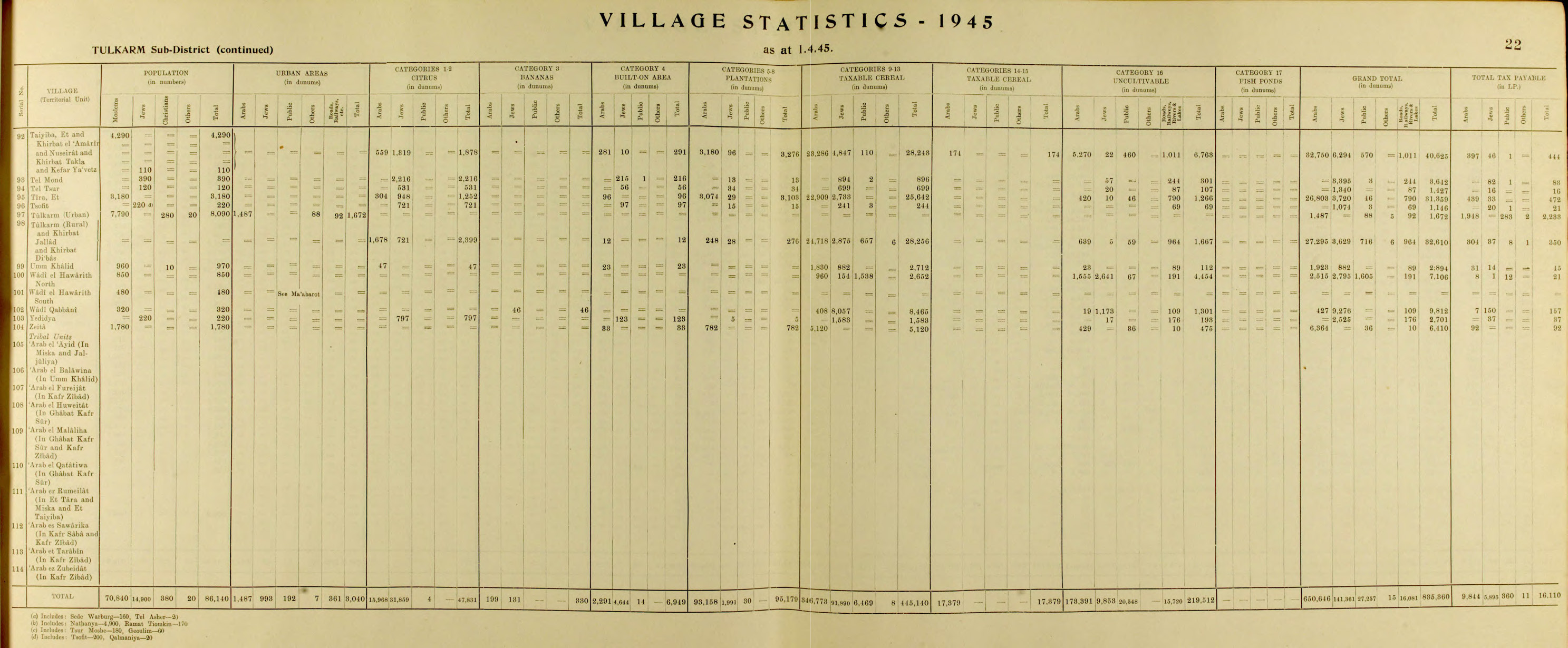
In the 1945 statistics the population of Tulkarm consisted of 8,090; of whom 7,790 were Muslims, 280 Christian and 20 "other",[23] with a land area of 1,672 dunams (urban) and 32,610 dunams (rural), according to an official land and population survey.[24] Of this, 2,399 dunams were designated for citrus and bananas, 276 plantations and irrigable land, 28,256 for cereals,[25] while 1,492 dunams were built-up areas.[26]
Jordanian rule
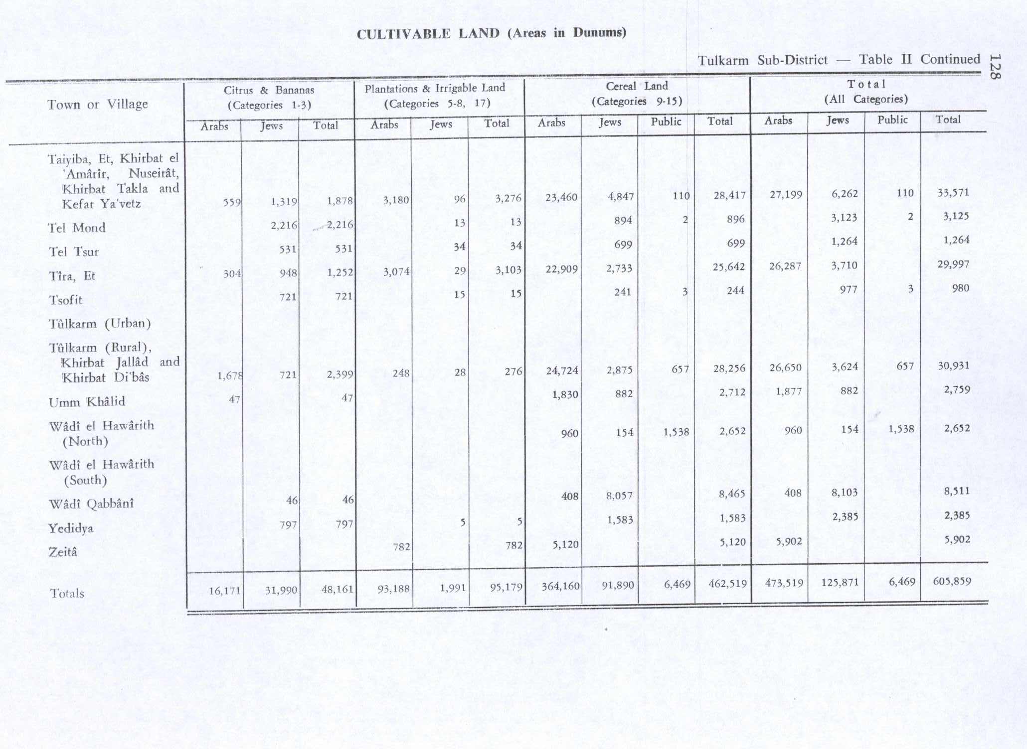
[edit]During the 1948 Arab–Israeli War, Tulkarm was occupied by the Iraqi Army and later annexed as part of the Jordanian-held West Bank. The 1949 Armistice Agreements between Israel and Jordan left roughly 30,000 dunams of Tulkarm's 32,610 dunams of land, mostly agricultural, in Israeli territory. In consequence, many residents moved to Transjordan or went abroad in search of employment.[27] Straddling the armistice line, Tulkarm was cut off from nearby Arab towns. Its principal economic and social connection was with Nablus.[28]
In 1950, the Tulkarm Camp was established by UNRWA in the city, comprising an area of 0.18 square kilometres (0.07 sq mi). Most of the refugees who resided in the camp came from Jaffa, Caesarea and Haifa. Today it is the second largest Palestinian refugee camp in the West Bank.[29] A period of significant municipal expansion began in Tulkarm after a new civil development scheme was authorized in 1961. As part of this plan, in 1963, the hamlet of Jarrad in the southeast and other lands in the northeast (total of 1.8 square km) were annexed to the city, while the eastern village of Dhinnaba was incorporated into the municipality in 1964, adding another 0.75 square kilometres (0.29 sq mi) of territory. The village of Shuweika to the north and the smaller village of Irtah to the south were annexed in 1967.[30]
Contemporary period
[edit]
Since the Six-Day War in 1967, Tulkarm has been under Israeli occupation.[20] A military government governed Tulkarm until transfer in 1982 to the Israeli Civil Administration.
During the early months of the First Intifada, 16 May 1989, Muhammad As'ad Fokhah, 50 years old, from Shuweika, died in Megiddo prison after a three-day hunger strike. Yitzhak Rabin reported to a Member of Knesset that Fokhah died of a heart attack caused by dehydration and that the military investigation found that prison staff had acted in accordance with orders.[31]
In the wake of the 1993 Oslo Accords between Israel and the Palestine Liberation Organization (PLO), control of Tulkarm was transferred to the Palestinian National Authority (PNA) on 10 December 1995, becoming the third Palestinian city from which Israeli forces withdrew.[20] During the early years of the Second Intifada, Israel temporarily reoccupied Tulkarm. Israeli military administration over Tulkarm ended in 2005, when control of the city was handed back to the PNA.[32] Upon assuming control of the city, the PNA instituted new weapons restrictions limiting militants to a single registered weapon that may not be loaded or carried in public.[33]
On 19 October 2023, the IDF entered the city.[34] In August 2024, Israeli bulldozers destroyed miles of the city, including homes, businesses and infrastructure; Israeli soldiers blocked emergency responders from assisting residents. News reports include videos of this attack, as well as assertions by the Israel Defense Forces that it is rooting out terrorism; and that it "undertakes all feasible precautions to avoid damaging essential infrastructure," while acknowledging that these "operations in the area have caused unavoidable harm to certain civilian structures."[35]
Geography
[edit]The city is situated on the western edge of northern West Bank, about 15 kilometers (9.3 mi) west of Nablus further southwest of Jenin and 15 kilometers (9.3 mi) east of the Israeli coastal city of Netanya. It is bordered by the 1948 ceasefire line, with Israel's Central and Haifa Districts to the west, and Palestine's Qalqilya and Ramallah and al-Bireh Governorates to the south. Its central location between a plain and a mountain has made it commercially and strategically significant and has had a great impact on its growth. In the past, Tulkarm was a caravan station and a trading center for products from the city's surrounding villages and farms, as well as a point from which armies crossed to Egypt and the Levant (al-Sham).[citation needed]
Tulkarm is at the crossroads of three historically important arteries: A road which runs north from the Latrun area along the edge of the coastal plain to Mount Carmel, Mount Tabor, Mount Gilboa, Nazareth and the Galilee and the Golan Heights, a road which winds northward along the outer tier of hills from the Ajalon valley to the Jezreel Valley, and a road that rises from the Mediterranean Sea at modern-day Netanya east to Nablus. In the past it was a junction of the coastal railroad from north of Haifa to Cairo and a branch of the narrow gauge Hejaz railway to Damascus.[citation needed]
Demographics
[edit]| Year | Pop. | ±% |
|---|---|---|
| 1548 | 1,040 | — |
| 1596 | 968 | −6.9% |
| 1860s | 1,000 | +3.3% |
| 1922 | 3,350 | +235.0% |
| 1931 | 4,540 | +35.5% |
| 1938 | 5,700 | +25.6% |
| 1945 | 8,090 | +41.9% |
| 1961 | 11,401 | +40.9% |
| 1967 | 20,002 | +75.4% |
| 1997 | 39,805 | +99.0% |
| 2007 | 61,941 | +55.6% |
| 2017 | 64,532 | +4.2% |
| Source: [6][11][36][37][23][38][39][40][41][1][42] | ||
According to the 1922 census of Palestine conducted by the British Mandate authorities, Tulkarm had a population of 3,350 (3,109 Muslims, 208 Christians, 23 Jews, eight Samaritans, one Baha'i, and one Druze).[36] At the time of the 1931 census, Tulkarm had a population of 4,827 (4,540 Muslims, 255 Christians, 18 Jews, six Samaritans, and one Druze) with 541 in nearby suburbs (516 Muslims, 15 Jews, and 10 Christians).[37]
The village statistics of 1938 list Tulkarm's population as 5,700 with 629 in nearby suburbs (including 17 Jews).[42] The village statistics of 1945 list the population as 8,090 (7,790 Muslims, 280 Christians, and 20 "other").[43]
The populations of Tulkarm, Dhinnaba, Shuweika and Irtah steadily increased by an average of 2% annually between 1931 and 1961, with a drastic increase after the 1948 War as the area experienced an influx of Palestinian refugees. The Jews presumably left/fled during the war. Following the 1967 War, the population saw a temporary decrease as some residents fled to Jordan. In the 1967 census by the Israel Central Bureau of Statistics the population of Tulkarm city was recorded as 10,255, Tulkarm Camp as 5,020, Dhinnaba as 1,342, Irtah as 925, Shuweika as 2,332 and Khirbet Jarrad as 128, a total of 20,002.[39] Most of the inhabitants were Muslims, although there was a community of 103 Christians according to the census.[44]
In the first census by the Palestinian Central Bureau of Statistics (PCBS) in 1997, Tulkarm had a population of 33,921 and the Tulkarm Refugee Camp had a population of 5,884. Palestinian refugees made up 31.4% of the city's residents and 94% of the camp's inhabitants.[40] The sex ratio for the city was 50.7% male and 49.3% female. Over half (52.2%) of the city's population was under the age of 20, 44.5% were between the ages of 20 and 64 and 4.1% were over the age of 64.[45] In the 2007 PCBS census Tulkarm's population grew to 51,300 while the camp's increased to 10,641. The sex ratio for the city was 50.3% male and 49.7% female.[41]

Today the population is almost entirely Muslim. Prior to Israel's occupation of the city in 1967, there were an estimated 1,000 Christians living in Tulkarm, but roughly half of the community emigrated in the aftermath of the war, while most of the remaining Christians gradually emigrated afterward.[46] There are two Christian families who continue to live in Tulkarm,[46] who are part of the same extended family.[47] There is a Greek Orthodox church in the city dedicated to St. George,[46] built in the early 19th century.[47][48][better source needed] The church is active and opens for visitors.[46]
Climate
[edit]The climate of Tulkarm is Mediterranean and subtropical as the area surrounding it, with rainfall limited to the winter. The average temperature in the winter ranges from 8 to 16 °C (46 to 61 °F), while the average temperature in the summer ranges from 17 to 30 °C (63 to 86 °F). Tulkarm is distinguished by the moderating effect the sea breeze has on its climate because of its location in the mountains. The average temperature does not exceed 27 °C (81 °F) in August, while February's average temperature does not fall below 13.5 °C (56 °F). Humidity is moderate in summer, about 40-70%, though it rises in winter to between 70 and 85%. Tulkarm receives in excess of 550 millimeters (22 in) of rain yearly, which is dispersed and intermittent, characteristic of the Mediterranean Basin.
| Climate data for Tulkarm | |||||||||||||
|---|---|---|---|---|---|---|---|---|---|---|---|---|---|
| Month | Jan | Feb | Mar | Apr | May | Jun | Jul | Aug | Sep | Oct | Nov | Dec | Year |
| Mean daily maximum °C (°F) | 17.0 (62.6) |
17.5 (63.5) |
19.6 (67.3) |
23.9 (75.0) |
24.2 (75.6) |
28.3 (82.9) |
29.0 (84.2) |
30.0 (86.0) |
27.9 (82.2) |
26.0 (78.8) |
23.0 (73.4) |
19.2 (66.6) |
22.76 (72.97) |
| Mean daily minimum °C (°F) | 8.9 (48.0) |
8.7 (47.7) |
10.5 (50.9) |
13.6 (56.5) |
17.2 (63.0) |
20.6 (69.1) |
23.0 (73.4) |
23.6 (74.5) |
20.7 (69.3) |
18.5 (65.3) |
14.1 (57.4) |
10.9 (51.6) |
15.54 (59.97) |
| Average precipitation mm (inches) | 124.9 (4.92) |
92.2 (3.63) |
52.8 (2.08) |
23.6 (0.93) |
2.7 (0.11) |
2.8 (0.11) |
2.2 (0.09) |
0.7 (0.03) |
1.2 (0.05) |
28.0 (1.10) |
77.4 (3.05) |
135.5 (5.33) |
538.3 (21.19) |
| Average precipitation days | 13.9 | 11.7 | 8.6 | 3.6 | 1.4 | 3.2 | 2.0 | 0.7 | 0.8 | 3.9 | 8.0 | 11.8 | 63.7 |
| Source: Israel Meteorological Service[49] | |||||||||||||
The rainy season starts in October and continues through May. Between December and February, almost 70% of annual rainfall occurs, while 20% of annual rainfall occurs in October and November. Rain in June and September is rare and comes to negligible amounts. July and August have no rain at all, except for one rainfall of 1.5 millimeters (0.059 in) on July 10, 1995, in Tulkarm city (Tulkarm Agricultural Department). The mean annual rainfall in the city of Tulkarm is 642 millimeters (25.3 in) for the period from 1952 to 1995 (Tulkarm Agricultural Department).
Economy
[edit]
Prior to the 1948 War, Tulkarm had a major agricultural sector, with grain, olives and fruits, especially watermelons, being the major crops cultivated by in the town's lands.[20]
Education
[edit]
Palestinian Technical University - Kadoorie which is the sole governmental university in Palestine, was established as an agricultural college in Tulkarem during the British Mandate by an endowment from the Iraqi-born Jewish philanthropist J.S. Kadoorie in 1930 and then became a university in 2007. Other institutions of higher learning include Al-Quds Open University and two campuses of An-Najah National University.
There are seven high schools in Tulkarm, three for girls (al-Adawiah,[50] Jamal Abd al-Nasser,[50] and Al-Khawaja) and three for boys (al-Fadilia,[51] Ihsan Samara, and Adnan Sefareni) and a vocational school for both genders.


On September 24, 2016, the PA named a school in Tulkarem after Salah Khalaf. Tulkarem governor Issam Abu Bakr said that the school was named after “martyr Salah Khalaf in order to commemorate the memory of this great national fighter”.[52][53]
Culture
[edit]The traditional costumes of women from Tulkarm were plain, dark-colored gowns with or without embroidery, as most rural women were from the north of Palestine.[54] Today, embroidery is the main source of income for the women of the city.[19] The most popular embroidered images are maps of historic Palestine. The Palestinian dish musakhan is popular in the city. Tulkarm shares many of its cultural features with neighboring Haifa, Jenin, Nablus, Qalqilia, and Jaffa.[19]
A Tulkarm amusement park called Mega Land attracts tens of thousands of visitors on Muslim holidays.[55]
Sports
[edit]Tulkarm has 2 semi-professional soccer teams; Thaqafi Tulkarm and Markez Shabab Tulkarm. Both are in the Palestinian League Division One.
Sister cities
[edit]Tulkarm's sister cities include:[56]
 Cenon, France
- Nîmes, France
 Meknes, Morocco
 Santarém, Portugal
Notable people
[edit]- Sanaa Alsarghali
- Abu Salma (1909–1980)
- Akram Al-Ashqar, film maker
- Ekrem Akurgal, Turkish archaeologist born in 1911 in Tulkarm
- Khaled Abu Toameh, Palestinian Israeli-Arab Muslim journalist
- Mar'i al-Karmi (1580–1624)
- Mahmoud Al-Karmi (1889–1939)
- Hasan Karmi (1905–2007)
- Abdul-Ghani Al-Karmi (1906–1974)
- Hilmi Hanoun (1913–2001), long-term mayor of Tulkarm
- Zuhair Al-Karmi (1921–2009)
- Ameen Nayfeh, film maker and writer
- Bassam Lotfi (1940-2022)
- Alaa Shreiteh (1979–2024)
See also
[edit]References
[edit]- ^ a b c Preliminary Results of the Population, Housing and Establishments Census, 2017 (PDF). Palestinian Central Bureau of Statistics (PCBS) (Report). State of Palestine. February 2018. pp. 64–82. Retrieved 2023-10-24.
- ^ a b Palmer, 1881, p. 194
- ^ Edward William Lane, An Arabic–English Lexicon, vols. 6–8 ed. by Stanley Lane-Poole, 8 vols. (London: Williams and Norgate, 1863–93).
- ^ Carta's Official Guid to Israel and Complete Gazetteer to all Sites in the Holy Land. Carta. 1983. p. 446.
- ^ "Environmental Profile for The West Bank Volume 8" (PDF). 2007-02-02. Archived from the original (PDF) on 2007-02-02. Retrieved 2020-12-17.
- ^ a b c d e f g h i j k al-Salim, Farid (Autumn 2011). "Landed Property and Elite Conflict in Ottoman Tulkarm" (PDF). Jerusalem Quarterly. 47. Archived from the original on 2012-01-26.
{{cite journal}}: CS1 maint: bot: original URL status unknown (link) - ^ Hütteroth and Abdulfattah, 1977, p. 137
- ^ Palestine Exploration Quarterly Jan-Apr 1944. "Jacotin's Map of Palestine". D.H.Kellner. p. 161.
- ^ Karmon, 1960, p. 170 Archived 2019-12-22 at the Wayback Machine
- ^ Doumani, 1995, p. 54.
- ^ a b Guérin, Victor (1875). "Description Géographique, Historique, et Archéologique de la Palestine". p. 353.
- ^ Marom, Roy, "The Contribution of Conder's Tent Work in Palestine for the Understanding of Shifting Geographical, Social and Legal Realities in the Sharon during the Late Ottoman Period", in Gurevich D. and Kidron, A. (eds.), Exploring the Holy Land: 150 Years of the Palestine Exploration Fund, Sheffield, UK, Equinox (2019), pp. 212-231
- ^ Marom, Roy (2022). "The Oak Forest of the Sharon (al-Ghaba) in the Ottoman Period: New Insights from Historical- Geographical Studies, Muse 5". escholarship.org. Retrieved 2023-10-06.
- ^ Conder and Kitchener, 1882, SWP II, pp. 161-162
- ^ Farid Al-Salim (2015). Palestine and the Decline of the Ottoman Empire: Modernization and the Path to Palestinian Statehood. I. B. Tauris. p. 3.
- ^ Thawaba, 2009, p. 31.
- ^ Thawaba, 2009, p. 32.
- ^ Marom, Roy (January 2024). "The Palestinian Rural Notables' Class in Ascendancy: The Hannun Family of Tulkarm (Palestine)". Journal of Holy Land and Palestine Studies. 23 (1): 77–108. doi:10.3366/hlps.2024.0327.
- ^ a b c Semplici, Andrea and Boccia, Mario. Tulkarm: The Bountiful Mountain. Med Corporation. pp. 3-8.
- ^ a b c d Fischbach 2005, p. 494.
- ^ Thawaba, 2009, p. 36.
- ^ LeVine, Mark Andrew; Nimr, Sonia (2012). Struggle and Survival in Palestine/Israel. University of California Press. pp. 144–149. ISBN 9780520262539.
- ^ a b "Village Statistics – 1945". April 1, 1945. p. 22. Retrieved July 3, 2025.
- ^ Government of Palestine, Department of Statistics. Village Statistics, April, 1945. Quoted in Hadawi, 1970, p. 77
- ^ Government of Palestine, Department of Statistics. Village Statistics, April, 1945. Quoted in Hadawi, 1970, p. 128
- ^ Government of Palestine, Department of Statistics. Village Statistics, April, 1945. Quoted in Hadawi, 1970, p. 178
- ^ name="Fischbach494"/
- ^ Thawaba, 2009, p. 38.
- ^ Tulkarm Refugee Camp. United Nations Relief and Works Agency.
- ^ Thawaba, 2009, p. 37.
- ^ Talmor, Ronny (translated by Ralph Mandel) (1990) The Use of Firearms - By the Security Forces in the Occupied Territories. B'Tselem. download pp. 76, 82
- ^ Israel to hand over control of Jericho, Tulkarm in first West Bank transfers to Palestinians
- ^ Israeli troops hand over Tulkarm, bbc.co.uk. Retrieved 6 November 2022.
- ^ "9 more Palestinians killed by Israeli army in West Bank, bringing death toll to 77". Anadolu Agency. Archived from the original on 21 October 2023. Retrieved 19 October 2023.
- ^ Solomon, Erika; Leatherby, Lauren; Toler, Aric (September 28, 2024). "Israeli Bulldozers Flatten Mile After Mile in the West Bank". The New York Times. Retrieved 28 September 2024.
- ^ a b Barron, 1923, p. 6
- ^ a b Mills, 1932, p. 58
- ^ "Jordan Census 1961" (PDF). p. 13. Retrieved July 3, 2025.
- ^ a b "Households and Persons, By Residence, Sex, Age And Origin From Israel Territory and Locality" (PDF). Israel Central Bureau of Statistics (CBS). 1967.
- ^ a b "Palestinian Population by Locality and Refugee Status". Archived from the original on February 7, 2012. Retrieved 2008-05-28.. 1997 Census. Palestinian Central Bureau of Statistics (PCBS). 1999.
- ^ a b "Table 26 (Cont.): Localities in the West Bank by Selected Indicators, 2007" (PDF). Palestinian Central Bureau of Statistics. 2007. p. 108. Archived from the original (PDF) on 2010-12-10.
- ^ a b Village Statistics (PDF). 1938. p. 34.
- ^ Village Statistics (PDF). 1945. p. 22.
- ^ "The Christians, By Sex and Locality (Only Localities With At Least 20 Christians) Locality" (PDF). Israel Central Bureau of Statistics (CBS). 1967.
- ^ "Palestinian Population by Locality, Sex and Age Groups in Years". Archived from the original on February 12, 2012. Retrieved 2008-05-28.
{{cite web}}: CS1 maint: bot: original URL status unknown (link). 1997 Census. Palestinian Central Bureau of Statistics (PCBS). 1999. - ^ a b c d "Two Christian families in Tulkarem". Christian Media Center - Custodia Terra Sanctae. 2015-08-31.
- ^ a b West Bank Churches Burned in Light of Muslim Anger Over Papal Comments. FOX News, Originally published by Associated Press. 2006-09-18.
- ^ PCHR Condemns Attacks on Palestinian Churches. Palestinian Center for Human Rights. Electronic Intifada. 2006-09-17.
- ^ "Averages and Records for Tel Aviv (Precipitation, Temperature and Records [Excluding February and May] written in the page)". Israel Meteorological Service. Archived from the original on 2010-09-14.
- ^ a b Suleiman, Michael W., ed. (1989). Palestinian Education: A Threat to Israel's Security?. Association of Arab-American University Graduates. pp. 42–43. ISBN 9780937694855.
- ^ Srouji, Fathi Sad (June 1986). The Jordanian Food Economy: pPast, Present, and Future Prospects. Cornell University. p. ii.
- ^ "PA governor defends naming school after Black September chief". The Times of Israel.
- ^ "PA: Terrorism is part of our culture". 30 October 2016.
- ^ Karmi, 2004, p. 22.
- ^ The economic impact of Israeli-Arab visitors to the West Bank Archived 5 May 2016 at the Wayback Machine
- ^ "Sister Cities of Meknes, Morocco". sistercities.app. Retrieved 2025-09-19.
Bibliography
[edit]- Barron, J.B., ed. (1923). Palestine: Report and General Abstracts of the Census of 1922. Government of Palestine.
- Conder, C.R.; Kitchener, H.H. (1882). The Survey of Western Palestine: Memoirs of the Topography, Orography, Hydrography, and Archaeology. Vol. 2. London: Committee of the Palestine Exploration Fund.
- Doumani, B. (1995). Rediscovering Palestine, Merchants and Peasants in Jabal Nablus, 1700-1900. University of California Press.
- Fischbach, Michael R. (2005) [2000]. "Tulkarm". In Philip Mattar (ed.). Encyclopedia of the Palestinians (Revised ed.). New York: Facts on File, Inc. p. 494. ISBN 0-8160-5764-8.
- Government of Jordan, Department of Statistics (1964). First Census of Population and Housing. Volume I: Final Tables; General Characteristics of the Population (PDF).
- Government of Palestine, Department of Statistics (1945). Village Statistics, April, 1945.
- Guérin, V. (1875). Description Géographique Historique et Archéologique de la Palestine (in French). Vol. 2: Samarie, pt. 2. Paris: L'Imprimerie Nationale.
- Hadawi, S. (1970). Village Statistics of 1945: A Classification of Land and Area ownership in Palestine. Palestine Liberation Organization Research Center.
- Hütteroth, W.-D.; Abdulfattah, K. (1977). Historical Geography of Palestine, Transjordan and Southern Syria in the Late 16th Century. Erlanger Geographische Arbeiten, Sonderband 5. Erlangen, Germany: Vorstand der Fränkischen Geographischen Gesellschaft. ISBN 3-920405-41-2.
- Karmon, Y. (1960). "An Analysis of Jacotin's Map of Palestine" (PDF). Israel Exploration Journal. 10 (3, 4): 155–173, 244–253. Archived from the original (PDF) on 2019-12-22. Retrieved 2015-04-16.
- Mills. E., ed. (1932). Census of Palestine 1931. Population of Villages, Towns and Administrative Areas. Jerusalem: Government of Palestine.
- Palmer, E.H. (1881). The Survey of Western Palestine: Arabic and English Name Lists Collected During the Survey by Lieutenants Conder and Kitchener, R. E. Transliterated and Explained by E.H. Palmer. Committee of the Palestine Exploration Fund.
- Thawaba, Salem (2009). "Urban growth of a city under siege: Tulkarm, Palestine over the past century". Journal of Planning History. 28: 27–46. doi:10.1177/1538513208327682. S2CID 145142269.
External links
[edit] Media from Commons
 Travel information from Wikivoyage
- Welcome To Tulkarm R.C.
- Tulkarem City, Welcome to Palestine
- Survey of Western Palestine, Map 11: IAA, Wikimedia commons
- Al-Salim, Farid. Tulkarm Landed Property and Elite Conflict in Ottoman Tulkarm Jerusalem Quarterly.
- Official website www.tulkarm.org Archived 2022-02-16 at the Wayback Machine
- www.mtulkarm.com

| International | |
|---|---|
| National | |
Tulkarm
View on GrokipediaEtymology
Name Origins and Interpretations
The name Tulkarm (Arabic: طُولْكَرْم, romanized: Ṭūlkarm) originates from the Aramaic compound "Tur Karm," where tur denotes a mountain or hill and karm refers to a vineyard, collectively signifying "mountain of the vineyard."[7][8] This etymology reflects the region's historically fertile coastal plain, conducive to viticulture, with archaeological and linguistic evidence linking the term to ancient Semitic agricultural practices in the area.[9] The name persisted through the Islamic conquests, evolving phonetically in Arabic usage while retaining its descriptive essence tied to the local topography of low hills amid arable land.[10] Earlier historical records from the Roman period, dating to the 3rd century CE, identify the settlement as Birat Soreqa (or Berat Soraqa), interpreted as "well of the chosen vineyard," underscoring a continuity in vineyard-related nomenclature that predates the Aramaic form.[11] Canaanite-era references, though less precisely documented, similarly evoke grape cultivation, such as variants like "Tel Karmeta al-'Inab" (mound of the grape vineyard), aligning with the area's Iron Age agricultural prominence.[10] By the Ottoman era in the 18th century, the name had standardized as Tulkarm, a phonetic adaptation possibly influenced by Arabic dialectal shifts from tul (long or extended) to emphasize the elongated ridge, though primary derivations remain rooted in Tur Karm.[12] Interpretations of the name emphasize its descriptive rather than symbolic function, highlighting causal links between the site's elevation (approximately 50–100 meters above sea level) and surrounding orchards, which supported economic vitality through grape, fig, and olive production until modern disruptions.[9][13] Alternative folk etymologies, such as "bountiful mountain" or "noble mound" (tell karim), appear sporadically in informal accounts but lack substantiation from historical linguistics, contrasting with the vineyard consensus derived from toponymic patterns in Aramaic-influenced Levantine place names.[14] The persistence of this agrarian connotation underscores Tulkarm's pre-industrial identity as a viticultural hub, verifiable through Ottoman tax records noting vineyard yields in the district.[11]History
Ancient and Medieval Periods
Archaeological surveys in the Tulkarm area reveal evidence of human activity from prehistoric periods, including flint tools dating to approximately 8000 years ago, though these findings are regional rather than specific to the modern city's core.[15] Nearby sites, such as Khirbet Irtah located 3 km south of Tulkarm, contain Roman-era remains, including a bathhouse and structures indicating a commercial hub, suggesting the site's strategic importance along ancient trade routes during the 3rd century CE and later.[16] However, no substantial evidence confirms a continuous urban settlement at Tulkarm itself during the Bronze Age, Iron Age, or classical periods; the locality appears to have functioned primarily as agricultural land amid broader Canaanite and Roman influences in the Sharon plain.[7] The establishment of Tulkarm as a recognized village occurred during the late Ayyubid period, around 1230 CE, when Arab peasant farmers and herders migrated from southern Palestine to the area following the Muslim reconquest under Saladin in 1187 CE.[17] These settlers capitalized on the fertile Wadi al-Sha'ir valley, engaging in crop cultivation and livestock grazing, which laid the foundation for the community's agrarian economy.[17] During the subsequent Mamluk era (1260–1516 CE), much of Tulkarm's surrounding farmland was designated as waqf land under religious endowment, administered for charitable or pious purposes, which influenced local land tenure and elite structures persisting into later periods.[17] Medieval Tulkarm remained a modest rural outpost at the crossroads of regional routes connecting the coastal plain to inland highlands, with limited documentation in contemporary chronicles, reflecting its peripheral role amid larger conflicts between Ayyubids, Crusaders, and Mamluks.[17] The waqf system helped stabilize land use but also fostered conflicts among local elites over property rights, as seen in disputes involving migrant families who integrated into the village's social fabric.[17] By the end of the medieval period, Tulkarm's population consisted primarily of Arab Muslim fellahin, setting the stage for Ottoman administrative incorporation without evidence of significant non-Muslim communities or fortifications within the village proper.[17]Ottoman Era
Tulkarm entered Ottoman rule following the conquest of Palestine in 1516, functioning primarily as a rural village within the nahiya of Wadi al-Sha'ir, later incorporated into the Bani Sa'b nahiya under the Nablus Sanjak.[17] Early Ottoman tax registers, known as Defterler-i Mufassal, documented it as a waqf village designated to support the al-Jawhariyya Madrasa attached to the Dome of the Rock in Jerusalem, with peasants paying one-third of their harvest in kind as qasm taxes, such as 7,000 kg of wheat and 14,000 kg of barley recorded in 1548.[17] Population estimates from these registers indicate modest sizes: 95 households (approximately 522 persons, assuming 5.5 per household) in 1535, rising to 189 households (about 1,040 persons) by 1548, and 176 households (roughly 968 persons) in 1596, predominantly Sunni Muslim fallahin engaged in subsistence agriculture under communal musha' land tenure.[17] The village's elite comprised local notable families managing waqf administration and taxation, including the Fuqaha as overseers, amid occasional conflicts such as the mid-17th-century massacre of the Kurdish Zaydan family due to excessive tax demands, which shifted influence to families like Badran.[17] By the 19th century, Tanzimat reforms transformed land and administration; the 1858-1859 Ottoman Land Code enabled privatization, allowing notables to accumulate holdings previously held communally or as state waqfs, with two-thirds of Tulkarm's lands originally waqf-designated but canceled by 1905 and reassigned to the Hijaz Railroad waqf.[17] [18] The Hannun family, originating from Transjordanian Huwaytat Arabs and resettling in Tulkarm mid-century, exemplified this ascent as tax farmers (multazimun), amassing around 20,000 dunams by the early 20th century, including pioneering citrus groves like Bayyarat Hannun established circa 1891, and securing administrative roles such as council seats in the Bani Sa'b nahiya from 1882.[18] Administrative elevation occurred in the 1870s-1880s when Tulkarm became the center of a qada' (subdistrict), reflecting its strategic position at transport junctions, followed by formal municipality status in 1892 alongside construction of government buildings like a post office, hospital, and school.[19] [18] The economy centered on agriculture, with the musha' system persisting until reforms, though late Ottoman developments included the Hejaz railway line and an agricultural school by 1918; the population remained under 2,000 in the early 1900s, housed in about 88 buildings clustered around a mosque and public space.[19] During World War I, Tulkarm served as an Ottoman military base in the Sinai and Palestine campaign, subjected to British aerial bombings, marking the era's turbulent close.[19]British Mandate Period
During the British Mandate for Palestine (1920–1948), Tulkarm functioned as the administrative center of the Tulkarm Subdistrict, an area characterized by agricultural productivity, particularly in citrus cultivation. Local notable families, such as the Hannuns, who had established citrus groves like Bayyarat Hannun spanning 600 dunams since the late Ottoman period, expanded operations under Mandate policies that facilitated land registration and export markets. The number of Arab-owned citrus plantations (bayyarat) in the coastal region rose from 31 in 1918 to over 250 by 1942, driven by investments in irrigation and wells funded partly by land transactions.[18][20] This growth reflected broader Mandate-era improvements in health services and infrastructure, contributing to population increases, though precise subdistrict figures varied due to migration and economic shifts.[18] Land sales by rural elites to Jewish purchasers marked a contentious aspect of Tulkarm's development, with prices escalating from approximately 1.5 Palestine pounds per dunam in the 1920s to over 100 by the 1940s amid rising demand. The Hannun family, leveraging their holdings, sold 10,000 dunams in 1932 for settlements including Even Yehuda and Kfar Tsur, followed by 4,500 dunams in 1938 for sites like Beit Yehoshua and Tel Yitshaq, and additional parcels in 1947 for the Hadassim youth village. These transactions, while economically rational for sellers amid British encouragement of private land markets, fueled Arab nationalist opposition, viewing them as threats to communal land tenure and demographic balance; by 1938, Jews owned 32.7% of coastal plain land in the subdistrict, far exceeding the national average of 6%.[18][20] Such sales often led to intra-Arab conflicts, exemplified by the 1937 assassination of Hasan Hannun and the 1939 killing of Dr. Rashad Hannun, attributed to disputes over property dealings.[18] Tulkarm emerged as a focal point of resistance during the Arab Revolt of 1936–1939, serving as a hub for nationalist activities against British rule and Jewish immigration. British efforts to curb agrarian crime in the subdistrict succeeded in reducing incidents, but underlying tensions persisted, with pro-British rallies, such as one in October 1939 at Bayyarat Hannun attended by hundreds, highlighting divided loyalties among locals. Educationally, the establishment of an agricultural school in Tulkarm accommodated 55 students, aiming to modernize Arab farming practices, though its limited scale constrained broader impact on rural development.[18][21][22] By the late Mandate years, these dynamics—agricultural expansion juxtaposed with land disputes and political unrest—positioned Tulkarm amid escalating communal frictions leading into the 1947–1948 conflict.[20]1948 War and Jordanian Annexation
During the 1948 Arab–Israeli War, the Tulkarm Subdistrict of Mandatory Palestine saw significant territorial division along military front lines. Israeli forces captured western villages within the subdistrict, including Qaqun on June 4–5, 1948, by the Alexandroni Brigade, and al-Manshiyya around April 15, 1948, resulting in the expulsion or flight of their Palestinian inhabitants eastward.[23][24] The city of Tulkarm itself remained under control of Jordanian Arab Legion and Iraqi troops, serving as a defensive position near the front but escaping major direct assaults.[25] This conflict led to a substantial influx of Palestinian refugees into Tulkarm from adjacent areas seized by Israeli forces, markedly altering the city's demographics and straining its resources.[25][7] The Israel-Jordan Armistice Agreement, signed on April 3, 1949, as part of the 1949 Armistice Agreements, delineated the Green Line that positioned Tulkarm directly along the border, with Israel incorporating much of the subdistrict's fertile western lands previously used for agriculture by Tulkarm residents.[25] Jordan thereby assumed de facto control over Tulkarm and the eastern remnants of the subdistrict immediately following the war's end in early 1949, administering the area amid ongoing refugee settlement and economic disruption from lost territories.[26] On April 24, 1950, Jordan formally annexed the West Bank, encompassing the districts of Jenin, Nablus, Tulkarm, Ramallah, Hebron, and East Jerusalem, thereby unifying them politically with the East Bank under the Hashemite Kingdom and extending Jordanian citizenship to West Bank Palestinians, including Tulkarm's population.[26][27] This act, decided upon by King Abdullah I as early as December 1948, faced widespread international rejection as illegal, receiving formal recognition only from Britain and Pakistan.[28] Under Jordanian rule, Tulkarm functioned as a district center, though its proximity to the armistice line imposed restrictions on movement and development.[25]Israeli Control (1967–1990s)
Israeli forces completed the capture of Tulkarm on June 7, 1967, as part of operations on the Jordanian front during the Six-Day War, securing control over the city and surrounding areas previously administered by Jordan.[29] The occupation integrated Tulkarm into Israel's broader military administration of the West Bank, where a military government oversaw security, civil services, and resource allocation under the framework of belligerent occupation.[25] This structure maintained Jordanian legal codes where applicable but subordinated them to Israeli military orders, facilitating direct oversight of local municipalities and infrastructure.[30] In November 1981, Israel issued orders establishing the Civil Administration to manage non-military civilian functions across the West Bank, including education, health, and local governance, marking a shift from pure military rule; implementation in areas like Tulkarm followed in 1982, with Israeli officials coordinating alongside appointed Palestinian mayors and councils.[31] Under this administration, Tulkarm experienced urban expansion and infrastructure improvements, such as road networks linking to Israel, though subject to military permits and security restrictions.[32] Economic ties deepened as residents gained access to Israeli labor markets, with many commuting daily for work in construction and agriculture, boosting household incomes and remittance flows in the initial decades.[33] Settlement activity emerged nearby, with outposts and industrial zones like those associated with Tulkarm factories established in the late 1970s and 1980s on expropriated lands, often justified for security or economic purposes, altering local land use patterns.[34] Specific developments included the Avnei Hefetz settlement south of Tulkarm, founded in the early 1980s, which expanded amid government support for Jewish habitation in the region.[35] These projects involved land seizures, reported by Palestinian sources to displace farming communities, though Israeli policy emphasized buffer zones near the Green Line.[36] Tensions escalated with the outbreak of the First Intifada in December 1987, as Tulkarm became a site of protests, stone-throwing clashes, and commercial strikes against the occupation, prompting Israeli responses including curfews, arrests, and troop deployments across the West Bank.[37] By the early 1990s, sustained unrest and international pressure contributed to negotiations, culminating in the 1993 Oslo Accords, which initiated phased withdrawals and transferred partial civil authority in Tulkarm to the emerging Palestinian Authority framework by 1995.[38]Palestinian Authority Era and Intifadas
Following the Oslo Accords of 1993, Tulkarm was transferred to Palestinian Authority (PA) control in 1995 as part of Area A under the Interim Agreement, granting the PA responsibility for civil administration and internal security in the city and surrounding areas. This shift enabled initial economic stabilization and modest urban expansion, including infrastructure improvements, though constrained by ongoing Israeli security oversight and checkpoints. The PA established local governance structures, with Tulkarm serving as the capital of its namesake governorate, but enforcement of law and order remained inconsistent due to factional rivalries and limited resources.[39] The Second Intifada, which began in September 2000 amid the collapse of peace talks, saw Tulkarm emerge as a hub for militant activities orchestrated by groups such as Palestinian Islamic Jihad and Hamas operatives within PA-controlled territories. Refugee camps like Tulkarm Camp and Nur Shams, densely populated with over 20,000 residents combined, harbored cells that facilitated smuggling of weapons and planning of attacks, including shootings and attempted infiltrations into Israel. PA security forces, intended to coordinate with Israel under Oslo, proved ineffective in curbing these networks, with some reports indicating tacit tolerance or direct involvement by elements linked to Fatah's Tanzim militia.[6][40] Israeli responses included Operation Defensive Shield in 2002 and subsequent raids, involving thousands of arrests and targeted operations to dismantle terror infrastructures, which severely disrupted camp life through curfews, home demolitions of militants' residences, and infrastructure damage. These actions followed a surge in attacks originating from the Tulkarm area, contributing to over 1,000 Israeli deaths nationwide during the Intifada, though specific attributions from Tulkarm vary by source. The period ended with Israel's 2005 disengagement from Gaza and partial West Bank barrier construction, which isolated Tulkarm further, reducing infiltrations but exacerbating local economic isolation under continued PA rule.[41][42]Geography
Location and Borders
Tulkarm lies in the northwestern West Bank, at approximately 32°19′N 35°02′E, serving as the administrative capital of the Tulkarm Governorate.[2] The city occupies a strategic position near the Green Line, the 1949 Armistice Line demarcating the boundary with Israel to the west.[43] The western edge of Tulkarm directly adjoins Israeli-controlled territory, positioning it about 12 km from the Mediterranean Sea and facilitating historical trade links across the border.[4] To the east, it connects to other Palestinian localities within the West Bank, including villages such as Anabta and Deir al-Ghusun to the northeast.[44] Northward, the area interfaces with the Jenin Governorate, while southward it approaches Qalqilya Governorate, enclosing a compact urban zone amid agricultural plains.[45] The Tulkarm Governorate, encompassing the city, spans 268 square kilometers and borders Israeli districts including the Menashe Regional Council to the northwest and HaSharon to the southwest, underscoring its frontline status along the separation line.[1] This proximity has shaped access dynamics, with checkpoints regulating movement across the Green Line since the Oslo Accords.[6]Topography and Environment
Tulkarm occupies a position in the northwestern West Bank at an average elevation of approximately 120 meters above sea level, with terrain varying from 50 to 150 meters in the immediate vicinity.[3][46] The local topography consists of smooth to gently sloping plains, forming part of the transitional zone between the Samarian hills to the east and the coastal lowlands extending from the Mediterranean Sea roughly 10 kilometers westward.[47] This relatively flat landscape facilitates agricultural activity and urban expansion, though it is interspersed with low undulations and wadi channels that drain toward the sea.[47] The environment features fertile alluvial and loess soils derived from surrounding limestone formations, which are well-suited for crop cultivation including olives, citrus fruits, and vegetables.[47] Vegetation is predominantly Mediterranean scrub and agricultural fields, with limited natural woodland due to historical land use pressures. Water resources rely heavily on the shallow coastal aquifer, providing groundwater as the sole supply for domestic and irrigation needs, though extraction exceeds recharge rates, leading to declining water tables.[47] Environmental stressors include soil salinization from over-irrigation and potential contamination of groundwater by nitrates from fertilizers, concentrated in areas of intensive farming adjacent to urban zones.[48][49]Climate
Weather Patterns
Tulkarm exhibits a Mediterranean climate with distinct seasonal weather patterns, featuring prolonged hot and arid summers from May to September, followed by mild and wet winters from November to March, and transitional shoulder seasons. During summer, daytime highs typically range from 28°C to 32°C (82°F to 90°F), with low humidity and negligible precipitation, often less than 2 mm per month in July and August, fostering clear skies and minimal cloud cover. Nighttime lows hover around 18°C to 20°C (64°F to 68°F), contributing to muggy conditions due to occasional coastal influences despite the inland location. Winters bring cooler temperatures, with average highs of 15°C to 18°C (59°F to 64°F) and lows of 7°C to 9°C (45°F to 48°F) in January, accompanied by the bulk of annual rainfall, concentrated in short, intense events that can lead to localized flooding. The rainy season generally commences in October and extends through April, with over 80% of the approximately 500-600 mm annual precipitation occurring then, though variability is high, as evidenced by Tulkarm recording 866.7 mm in the 2023-2024 season, 144% above the long-term mean.[50][47] Extreme weather events punctuate these patterns, including summer heat waves exceeding 35°C (95°F) and winter cold snaps dipping below 5°C (41°F), alongside occasional storms with hail or strong winds during precipitation peaks. Spring (March-May) and autumn (September-October) serve as mild transitions, with increasing or decreasing rainfall, respectively, and temperatures bridging summer and winter norms. Historical data indicate low interannual variability in temperature but significant fluctuations in precipitation, influenced by broader Mediterranean teleconnection patterns, which can amplify drought risks in dry years or excessive runoff in wet ones.[51][52][53]| Month | Avg. High (°C) | Avg. Low (°C) | Avg. Precipitation (mm) |
|---|---|---|---|
| January | 17 | 8 | 130-150 |
| February | 17-18 | 8-9 | 100-120 |
| March | 19-20 | 10 | 70-90 |
| April | 22-23 | 12 | 30-40 |
| May | 26-27 | 15 | 10-15 |
| June | 28-29 | 17-18 | <5 |
| July | 30 | 19 | 2 |
| August | 31-32 | 20 | <1 |
| September | 29 | 18 | 5-10 |
| October | 26 | 15 | 25-30 |
| November | 22 | 12 | 60-80 |
| December | 18 | 9 | 120-140 |
Environmental Challenges
Tulkarm district experiences acute water scarcity, with annual consumption historically around 22.2 million cubic meters in 1994, predominantly for agriculture (16.62 MCM), while supply from municipal wells remained limited at approximately 4 million cubic meters across Tulkarm and nearby Qalqiliya in 1995.[47] Projections indicated demand could reach 91.14 MCM by 2020, straining shared aquifers amid restrictions on Palestinian extraction.[47] Farmers increasingly depend on costly tankered water, undermining agricultural viability in this fertile plain.[4] Groundwater quality is compromised by nitrates and chlorides from fertilizers, pesticides, and sewage infiltration, with electrical conductivity levels averaging 646 µS/cm in Tulkarm samples from 1995, signaling salinity risks.[47] Assessments confirm elevated nitrate concentrations in area wells, often exceeding safe thresholds due to overpumping and untreated domestic wastewater from cesspits used by 70% of households.[54][47] Industrial effluents, including from stone-cutting (5,805 m³/year), are frequently discharged into wadis or cesspits, further contaminating aquifers.[47] Sewage management failures exacerbate pollution, as only 30% of structures connect to sewer networks, leading to untreated discharge into valleys that recharge groundwater.[47] Solid waste generation reached 175 tons daily in the mid-1990s, with uncontrolled dumping at over 20 sites leaching contaminants into soil and water despite 87% collection coverage.[47] Nearby Israeli settlements contribute nitrates and fecal matter via wastewater overflows, as documented in municipal and university analyses, compounding health risks like respiratory diseases and infections.[55][56] Soil degradation arises from wastewater irrigation, pesticide overuse (58.8 tons in 1993/94), and urban expansion on rendzina soils, reducing fertility in agricultural lands vital to the local economy.[47] These challenges persist amid broader West Bank patterns of raw sewage infiltration, hindering sustainable resource use.[57]Demographics
Population Trends
The population of Tulkarm city grew modestly during the British Mandate era, from 3,349 inhabitants in the 1922 census to 4,827 in 1931 and 8,090 in 1945, reflecting agricultural expansion and rural-to-urban migration.[7][39] This early growth occurred amid a predominantly Muslim population with small Christian and other minorities, supported by the region's orange export economy. Following the 1948 Arab-Israeli War and Jordanian administration, the influx of Palestinian refugees contributed to further increases, with the city reaching approximately 9,000-10,000 by 1967 according to Israeli census estimates. Under Israeli control from 1967 to the 1990s, natural increase dominated trends, with high fertility rates (averaging 6-7 children per woman in the West Bank during this period) driving expansion despite limited emigration opportunities. By the late 1990s, Palestinian Central Bureau of Statistics (PCBS) data indicated a population of around 39,000-43,000, incorporating urban development and refugee camp adjacency.| Year | Population (Tulkarm City) | Source |
|---|---|---|
| 1997 | ~39,058 | PCBS via urban study[39] |
| 2007 | 51,300 | PCBS census[58] |
| 2017 | 64,532 | PCBS census[58] |
| 2023 | 71,161 | PCBS estimates |