
Community hub
Recent from talks
Contribute something
Nothing was collected or created yet.
Jenin
View on Wikipedia32°27′40″N 35°18′00″E / 32.46111°N 35.30000°E
Jenin (/ʒɪˈniːn/ zhin-EEN; Arabic: جنين, romanized: Jinīn, locally pronounced [ʒɪˈniːn] ⓘ) is a city in the West Bank, Palestine, and is the capital of the Jenin Governorate. It is a hub for the surrounding towns.[2] Jenin came under Israeli occupation in 1967, and was put under the administration of the Palestinian National Authority as Area A of the West Bank, a Palestinian enclave, in 1995.[3]
Key Information


The city had a population of approximately 50,000 people in 2017, whilst the Jenin refugee camp had a population of about 10,000, housing families of Palestinians who fled or were expelled from their homes during the 1948 Palestine War.[1][4] The camp has since become a stronghold of Palestinian militants, being the location of several incidents relating to the Israeli–Palestinian conflict.
Etymology
[edit]Jenin has been identified as the place "Gina" or "Ginah" mentioned in the Amarna letters from the 14th century BCE, as a town in Canaan.[5] Jenin is commonly identified with the later biblical city of Ein-Ganim,[6][7][8][9] from Hebrew: עֵין גַּנִּים, meaning "the spring of gardens"[10] or "the spring of Ganim",[11] probably referring to the many springs located nearby. The present-day Arabic name is believed to preserve the city's ancient name.[6]
History
[edit]Ancient period
[edit]Jenin is identified with a number of important towns mentioned in ancient sources. Throughout history, it was referred to as "Ein Ganim", "Beth Hagan", "Ginah", and "Ginae", along other names.[5][9]
Tell Jenin, believed to constitute the original settlement core of the city, is located at the center of what is today Jenin's business district.[6][12] The tell is also known as Tell el-Nawar, a term derived from the Arabic word for "gypsies," due to former nomadic encampments in this site. The earliest settlement at the tell dates to the late Neolithic and the early Chalcolithic. In the early 20th century, the tell was occupied by a modern cemetery and a threshing floor.[13]
Bronze Age
[edit]Jenin has been identified as the place Gina or Ginah mentioned in the Amarna letters from the 14th century BCE. At the time, it was a vassal state of the New Kingdom of Egypt.[14][5] The people of Gina managed to kill the warlord Labaya during the reign of Pharaoh Akhenaten.[15]
Iron Age
[edit]Jenin is identical to Ein-Ganim, which the Hebrew Bible describes as a Levite city belonging to the Israelite Tribe of Issachar.[5][9][16] It has also been associated with Beth-Haggan, mentioned in 2 Kings in connection with Ahaziah's flight from Jehu, before he is wounded at Ibleam and later dies in Megiddo.[5][9][17] The Book of Judith renders its name as Gini.[6][5]
Roman and Byzantine periods
[edit]Josephus, a Roman-Jewish historian of the 1st-century CE, mentions Ginae as being in the great plain, on the northern border of Samaria.[6][18][19] During the Roman period, Ginae was settled exclusively by Samaritans. The people of Galilee were disposed to pass through their city during the annual pilgrimages to Jerusalem.[20] In 51 CE, a Galilean Jew was killed in Ginae by hostile Samaritans while en route to Jerusalem to celebrate Sukkot. With Roman procurator Cumanus failing to respond, Jewish Zealots led by Elazar the Son of Deinaeus (Ben Dinai) sought vengeance, and several Samaritan villages in Aqrabatene were destroyed.[21][22]
Biblical commentator F. W. Farrar raised the possibility that this Samaritan village, "the first village at which [a traveler taking the road from Galilee to Judea over Mount Tabor] would arrive", was the one which rejected the disciples of Jesus in Luke's Gospel at the point where Jesus and his followers begin his journey towards Jerusalem.[23]
Ceramics dating from the Byzantine era have been found here.[24] There is no mention of Jenin in the reports of the Muslim conquest of the Levant from the Byzantines, which, according to the historian Moshe Sharon, "is not surprising, since it was a small place of minor importance".[25]
Crusader, Ayyubid and Mamluk periods
[edit]Jenin came under Crusader rule in 1103.[26] The Crusaders called it Le Grand Guerin (Latin: Garinum or Gallina Major),[25] to distinguish it from the town of Zir'in, which they called Petit Grin.[26] Under the Crusaders it was a small seigniory, forming part of the Principality of Galilee or the Kingdom of Jerusalem.[25]
Shortly before the Battle of Hattin in 1187, Jenin was captured by the Ayyubid sultan Saladin,[25] who destroyed the nearby fort, Castellum Beleismum.[27] In the 1220s, the geographer Yaqut al-Hamawi described Jenin as "a small and beautiful town, lying between Nabulus and Beisan, in the Jordan Province. There is much water, and many springs are found here, and often have I visited it."[28] In 1229, a peace was concluded between Frederick II, Holy Roman Emperor and Sultan al-Kamil, during the Sixth Crusade, whereby the city was given to the Crusaders, but Sultan as-Salih Ayyub was able to control it permanently in 1244 after the Battle of La Forbie.[citation needed]
In 1255, it was agreed between the Ayyubid sultan in Syria, an-Nasir Yusuf, and the first Mamluk sultan in Egypt, Izz al-Din Aybak, to give the latter all of the lands lying west of the Jordan River, and thus Jenin entered into the possession of the Mamluks.[citation needed] It was one of eleven subdistricts of Mamlakat Safad (Province of Safed).[29] In the late 13th century, Mamluk emirs (commanders) stationed at Jenin were ordered by Sultan Qalawun (r. 1279–1290) "to ride every day with their troops before the fortress of 'Akka, so as to protect the coast and the merchants."[30] As one of the stations of the Mamluk barid (postal route) between the Mamluk capital Cairo and Damascus, it was one of the towns where fires were lit to warn of a Mongol attack.[29] The geographer al-Dimashqi mentioned Jenin around 1300.[31] From the time of Qalawun's son, Sultan an-Nasir Muhammad (r. 1299–1309, 1310–1341), it was a station on the route where ice was transported to Cairo for the sultans' drink houses.[29] The Mamluk historian al-Qalqashandi (d. 1418) described Jenin as "an ancient spacious town which is riding on a shoulder of a nice valley in which there is a river of flowing water" north of Qaqun "on the top end of Marj Bani Amer [Jezreel Valley]".[29] He also noted that it contained the mausoleum of Dihyah al-Kalbi, a companion of the Islamic prophet Muhammad.[29]
Ottoman era
[edit]


The Ottomans conquered Mamluk Syria in 1516. Jenin became the administrative center of a nahiya (subdistrict) of the Lajjun Sanjak (Lajjun District).[29] The sanjak was officially called the Iqta (Fief) of Turabay until 1559 when it became officially known as the Lajjun Sanjak.[32] The Turabay dynasty was the ruling house of the Bedouin Banu Haritha tribe, whose members held the governorship of Lajjun from the start of Ottoman rule through 1677.[33]
The tax registers from 1548 to 1549 report that Jenin had a population of eight households, all Muslim. They paid a fixed tax rate of 25% on agricultural products, including wheat, barley, summer crops, goats and beehives, in addition to occasional revenues; a total of 2,000 akçe. All of the revenue went to a waqf (religious endowment) in the name of the Mamluk sultan Qansuh al-Ghuri (r. 1501–1516).[34] Turabay rule was occasionally interrupted, including in 1564, when a certain Kemal Bey was appointed sanjak-bey (district governor) by the Ottomans.[35] On 15 October 1564 Kemal Bey requested from the beylerbey (provincial governor) of Damascus that the stone caravanserai of Jenin be repaired, garrisoned and serve as the chief headquarters of the Lajjun sanjak-bey in order for Lajjun to prosper and for the road connecting Damascus to Jerusalem and Egypt to become secure. The official response was that the caravanserai be turned into a fortress; the fortress became ruined at some later point and 19th-century residents of Jenin used to claim that certain large rocks strewn in the village were the remnants of the 16th-century fortress.[36]
The Turabays, who remained nomads in the plain between Mount Carmel and Caesarea, made Jenin the administrative headquarters of Lajjun and used the town's Izz al-Din Cemetery to bury their dead.[37] A large, domed mausoleum was built for the grave of one of the chiefs and sanjak-beys of the family, Turabay ibn Ali (d. 1601). Known as Qubbat al-Amir Turabay (Dome of the Emir Turabay), it was described in a 1941 report as a ruined structure, and Sharon, writing in 2017, notes that it "does not exist anymore".[38] No other graves of the Turabays in Jenin had survived into the 20th century.[38] During the conflict between Fakhr al-Din of the Ma'n dynasty, who governed the sanjaks of Sidon-Beirut and Safed, and the Turabays, in 1623, Fakhr al-Din captured Jenin and stationed his men there. In 1624 the most prominent Turabay chief and sanjak-bey of Lajjun, Ahmad ibn Turabay, drove out the Ma'nid troops from Jenin and established his personal residence in the town.[39]
In the mid-18th century, Jenin was designated the administrative capital of the combined districts of Lajjun and Ajlun.[40] There are indications that the area comprising Jenin and Nablus remained functionally autonomous under Ottoman rule and that the empire struggled to collect taxes there. During the Napoleonic Campaign in Egypt which extended into Syria and Palestine in 1799, a local official from Jenin wrote a poem enumerating and calling upon local Arab leaders to resist Bonaparte, without mentioning the Sultan or the need to protect the Ottoman Empire.[41]
In the late 19th century, some members of the Jarrar family, who formed part of the mallakin (elite land-owning families) in Jenin, cooperated with merchants in Haifa to set up an export enterprise there.[42] During the Ottoman era, Jenin was plagued by local warfare between members of the same clan.[43] The French explorer Guérin visited in 1870.[44] In 1882, the PEF's Survey of Western Palestine described Jenin as "The capital of the district, the seat of a Caimacam, a town of about 3,000 inhabitants, with a small bazaar. The houses are well built of stone. There are two families of Roman Catholics; the remainder are Moslems. A spring rises east of the town and is conducted to a large masonry reservoir, near the west side, of good squared stonework, with a long stone trough. This reservoir was built by 'And el Hady, Mudir of Acre, in the first half of the century [..], north of the town is the little mosque of 'Ezz ed Din, with a good- sized dome and a minaret."[45]
British Mandate period
[edit]
According to a census conducted in 1922 by the British Mandate authorities, Jenin had a population of 2,637 (2,307 Muslims, 212 Hindus, 108 Christians, seven Jews, and three Sikhs).[46] A following census in 1931 showed a slight increase to 2,706 (2,610 Muslims, 103 Christians, two Jews, and one Druze) with another 68 in nearby suburbs (all Muslims).[47] From 1936, Jenin became a center of rebellion against the British Mandatory authorities. By the summer of 1938, residents of the city embarked on "an intensified campaign of murder, intimidation and sabotage" that caused the British administration "grave concern", according to a British report to the League of Nations;[48] the population had further increased to 3,100.[49] The city played an important role in the 1936–39 Arab revolt in Palestine, prompted by the death of Izz ad-Din al-Qassam in a fire-fight with British colonial police at the nearby town of Ya'bad months prior to the start of the revolt. On 25 August 1938, the day after the British Assistant District Commissioner was assassinated in his Jenin office, a large British force with explosives entered the town. Despite having captured and killed the assassin, British forces ordered the inhabitants to leave, and blew up one quarter of the town as a form of punishment.[50]
Jenin was used by Fawzi al-Qawuqji's Arab Liberation Army as a base.
The village statistics of 1945 list the population as 3,990 (3,840 Muslims and 150 Christians).[51]
1948 War
[edit]In the 1948 Arab–Israeli War, the city was defended by the Iraqi Army, then captured briefly by the forces from Israel's Carmeli Brigade during the "Ten Days' fighting" following the cancellation of the first cease-fire. Prior to the battle, the city's residents fled temporarily.[52] The offensive was actually a feint designed to draw Arab forces away from the critical Battle for Jerusalem, and gains in that sector were quickly abandoned when Arab reinforcements arrived.
Jordanian control
[edit]In the wake of the 1948 Arab–Israeli War, and after the 1949 Armistice Agreements, Jenin came under Jordanian rule. It was annexed by Jordan in 1950.
The Jenin refugee camp was founded in 1953 by Jordan to house displaced Palestinians who fled or were expelled during the 1948 War. In 2014 the camp had a population of 16,000. For 19 years, the city was under Jordanian control. A war cemetery for Iraqi soldiers and local combatants is located on the outskirts of Jenin.
The Jordanian census of 1961 found 14,402 inhabitants in Jenin.[53]
Israeli occupation 1967 to 2020
[edit]

.jpg)
Jenin has been under Israeli occupation since the Six-Day War, in 1967.[citation needed]
On 14 May 1989, during the early months of the First Intifada. Mohammad Jibrin, aged 45, died in Ramallah Hospital after being beaten by Israeli soldiers in Jenin. Three months later, in response to a question from a member of Knesset Defence Minister Yitzhak Rabin wrote that there was no investigation by the Military Police Investigator.[54]
According to Joel Beinin, Jenin was classified as under the administration of the Palestinian National Authority as Area A of the West Bank, a Palestinian enclave, in 1995.[3][verification needed] In 1996, Israel handed over control of the city to the Palestinian National Authority in keeping with the Oslo Accords.[verification needed]
According to the BBC, the city is "Known among Palestinians" as "the Martyrs' capital", but the reason they gave was Israeli statistics about suicide bombings, the BBC did not identify any non-Israeli source for the name.[55] During the Second Palestinian uprising (also known as the Al-Aqsa Intifada) the camp's militants, some 200 armed men, included members of Al-Aqsa Martyrs Brigades, Tanzim, Palestinian Islamic Jihad (PIJ) and Hamas.[56][57] By Israel's count, at least 28 suicide bombers were dispatched from the Jenin camp from 2000 to 2003 during the Second Intifada.[56] Israeli army weekly Bamahane attributes at least 31 militant attacks, totaling 124 victims, to Jenin during the same period, more than any other city in the West Bank.[58]
During the al-Aqsa Intifada, Israel launched Operation Defensive Shield with the stated aim of dismantling militant infrastructure so as to curb suicide bombings and other militant activities. The army encircled and entered six major Palestinian population centers in the West Bank, among them Jenin. During the Battle of Jenin (2002) in April 2002, 23 Israeli soldiers and 52 Palestinians, including civilians,[59][60] were killed.[61] Human Rights Watch reported that the refugee camp, which was the major battleground, suffered extensive damage. Witnesses stated unarmed people were shot and denied medical treatment, and as a result died. Human Rights Watch have regarded many killings to be unlawful such as the death of a 57-year-old wheelchair bound man who was shot and run over by a tank despite having attached a white flag on his wheelchair. A 37-year-old man who was paralysed was crushed under the rubble of his house, his family was not allowed to remove his body. A 14-year-old boy was killed as he travelled to purchase groceries during the temporary relief of the curfew that was imposed by the army. Medical staff were shot at (one nurse killed) while trying to reach the wounded even after clearly being in uniform displaying the red crescent symbol.[62] There have also been reports of Israeli soldiers using Palestinians as human shields, one father described how a soldier rested his rifle on his 14-year-old son's shoulder as he shot.[63] Israel denied the entry of rescue teams and journalists into Jenin even after they withdrew. Over the following years, Jenin was subject to extended curfews and targeted killings.
During a gun-battle with Islamic Jihad militants whom Israel says were firing at troops from inside the UN compound, an Israeli military sniper shot and killed a UN Relief and Works Agency (UNRWA) employee, Iain Hook (54) on November 22, 2002.[64] The sniper reportedly mistook a cellphone in Hook's hands for a gun or grenade.[65]
.jpg)
In the framework of the Valley of Peace initiative, a joint Arab-Israeli project is under way to promote tourism in the Jenin region.[66] In 2010, 600 new businesses opened in Jenin.[67] The Canaan Fair Trade is headquartered in Jenin.[68] Director of The Freedom Theatre in Jenin, Juliano Mer-Khamis, was killed by masked gunmen in the city in April 2011. Mer-Khamis co-founded the theatre with Zakaria Zubeidi, former military chief of the al-Aqsa Brigades who had renounced violence.[69]
Israeli occupation in the 2020s
[edit]On 6 February 2020, a Palestinian policeman, Tarek Badwan, was shot dead by an Israeli sniper as he stood at the entrance to the Jenin police station and chatted with a colleague. No explanation has been forthcoming. The incident was recorded on video.[70]
On 17 June 2022, Israeli forces conducted a raid in the al-Marah area of the city. During the raid, Israeli forces opened fire on a car, killing three Palestinians and seriously injuring another.[71]

On 26 January 2023, Israeli forces killed nine in a clash with Islamic Jihad militants during a raid in the city and refugee camp of Jenin.[72][73]
On 3 July 2023, shortly after 1 a.m., Israeli forces attacked the city's refugee camp using drone-fired missiles and ground troops. Eight Palestinians died from injuries sustained during the attack and a further eighty were injured, nine of them critically.[74][75] Fifty Palestinians, whom Israeli forces labeled "militants", were arrested. Israeli forces cut off telecommunications and electricity in the area and medical professionals struggled to reach the injured. Israel claimed that while they were targeting suspected members of the Jenin Brigades, an armed group, they acknowledged that innocent people may have been injured or killed in the raid. Yoav Gallant, the Israeli Minister of Defense, said "The operation is progressing as planned," and Eli Cohen, the Israeli Foreign Minister, said claimed the refugee camp had become a "center for terrorist activity" thanks to funding from Iranian sources.[76] The refugee camp has a population of roughly 17,000 inhabitants and is about a quarter a square mile in size.
On 19 September 2023, four Palestinians were killed during another Israeli military invasion of the city – among them a 15-year-old Palestinian boy, chased and killed for having noticed the Israeli undercover soldiers sneaking into the Jenin refugee camp.[77]
Gaza war
[edit]During the Gaza war, Israeli forces carried out multiple operations in Jenin. On October 22, 2023, the IDF conducted an airstrike targeting an underground compound beneath the Al-Ansar Mosque in the city. It was reported to be the first airstrike in the West Bank since the Second Intifada. The IDF stated that the strike aimed at operatives from Hamas and PIJ who were planning a terror attack.[78]
Jenin was severely damaged during the Gaza war. By June 2024 repeated bombing attacks and incursions with bulldozers by Israeli forces razed every street and reduced every public square to rubble. In one incident on 21 May, according to journalist Gideon Levy, an Israeli sniper shot dead bystanders, including surgeon Oussaid Jabareen, who was shot while on his way to work at the Jenin Government Hospital.[79][80]
In late August 2024 Israel launched a large-scale, multi-day raid on Jenin as part of Operation Summer Camps, with one resident saying that "The water is cut off. The electricity is cut off, the sewage system is no longer working. All the infrastructure is destroyed, we no longer have any services that work." The governor of Jenin said that "The Israelis are besieging the hospitals and cutting off the city from the refugee camp, which has become a military zone with no access...neither the civil defence, nor the ambulances, nor the journalists can go and see what is happening there." The IDF, on the other hand, says that this is operation is "not extremely different from regular activity".[81][82] At least 20 Palestinians were killed by the IDF in this attack,[83][84] including a Palestinian man in his 80s.[84] Additionally, the Israeli forces fired at ambulances carrying "a dead and a wounded person",[84] leading to the injury of 2 EMTs and a volunteer doctor.[85]
Also in August, Israeli bulldozers destroyed miles of the city, including homes, businesses and infrastructure; Israeli soldiers blocked emergency responders from assisting residents. News reports include videos of this attack, as well as assertions by the Israel Defense Forces that it is rooting out terrorism; and that it "undertakes all feasible precautions to avoid damaging essential infrastructure”, while acknowledging that these “operations in the area have caused unavoidable harm to certain civilian structures".[86]
In December 2024, the Palestinian Authority launched an anti-militant operation in Jenin, the largest in three decades, called "Protect the Homeland". The operation aims to regain control of the Jenin refugee camp, targeting militants and those fueling instability.[87][88]
On January 21, 2025, the IDF launched its own operation in Jenin, dubbed Iron Wall, aimed at clearing Jenin of militants and putting a stop to light arms being smuggled into the city.[89][90] Operations in Jenin were ongoing as of late February 2025. Around 100 homes had been demolished, residents were being prevented from returning to the area by military checkpoints, and Israeli tanks had been deployed.[91][92]
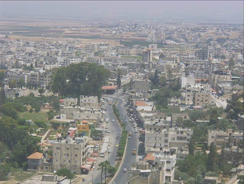
Geography
[edit]Jenin is situated at the foot of the rugged northernmost hills (Jabal Nablus) of the West Bank, and along the southern edge of the Jezreel Valley (Marj Ibn Amer),[93] which the city overlooks.[94] Its highest elevation is about 250 meters above sea level and its lowest areas are 90 meters above sea level.[95] Immediately southwest of Jenin is the Sahl Arraba plain (Dothan Valley), while further south is the Marj Sanur valley.[96] About 1.5 kilometers to Jenin's east is Mount Gilboa (Jabal Faqqua).[97]
Jenin is 42 kilometers north of Nablus, 18 kilometers to the south of Afula, and 51 kilometers southeast of Haifa.[98] The nearest localities are Umm at-Tut and Jalqamus to the southeast, Qabatiya and Zababdeh to the south, Burqin to the southwest, Kafr Dan to the west, Arranah, Jalamah and the Arab Israeli village of Muqeible to the north, Deir Ghazaleh to the northeast, and Beit Qad and Deir Abu Da'if to the east.
Climate
[edit]| Climate data for Jenin | |||||||||||||
|---|---|---|---|---|---|---|---|---|---|---|---|---|---|
| Month | Jan | Feb | Mar | Apr | May | Jun | Jul | Aug | Sep | Oct | Nov | Dec | Year |
| Mean daily maximum °C (°F) | 17.4 (63.3) |
18.2 (64.8) |
21.6 (70.9) |
28.3 (82.9) |
31.0 (87.8) |
32.9 (91.2) |
33.6 (92.5) |
34.2 (93.6) |
33.2 (91.8) |
30.6 (87.1) |
25.0 (77.0) |
18.8 (65.8) |
27.1 (80.8) |
| Daily mean °C (°F) | 12.1 (53.8) |
12.6 (54.7) |
15.1 (59.2) |
19.7 (67.5) |
22.5 (72.5) |
25.1 (77.2) |
26.6 (79.9) |
27.6 (81.7) |
26.5 (79.7) |
23.3 (73.9) |
18.4 (65.1) |
13.7 (56.7) |
20.3 (68.5) |
| Mean daily minimum °C (°F) | 6.8 (44.2) |
7.1 (44.8) |
8.6 (47.5) |
11.2 (52.2) |
14.0 (57.2) |
17.3 (63.1) |
19.6 (67.3) |
21.1 (70.0) |
19.8 (67.6) |
16.1 (61.0) |
11.8 (53.2) |
8.7 (47.7) |
13.5 (56.3) |
| Average rainy days | 11.0 | 6.5 | 11.5 | 5.0 | 0.0 | 0.0 | 0.0 | 0.0 | 0.0 | 4.5 | 6.0 | 11.0 | 55.5 |
| Average relative humidity (%) | 80 | 84 | 76 | 67 | 60 | 63 | 63 | 65 | 64 | 65 | 66 | 74 | 69 |
| Mean monthly sunshine hours | 167.4 | 158.2 | 210.8 | 234.0 | 300.7 | 339.0 | 344.1 | 310.0 | 273.0 | 251.1 | 204.0 | 167.4 | 2,959.7 |
| Mean daily sunshine hours | 5.4 | 5.6 | 6.8 | 7.8 | 9.7 | 11.3 | 11.1 | 10.0 | 9.1 | 8.1 | 6.8 | 5.4 | 8.1 |
| Source: Palestinian Meteorological Department[99] | |||||||||||||
Government
[edit]Jenin municipality was established in 1886 under the Ottoman rule with no more than 80 voters and elections were made every 4 years until 1982 when the Israeli government took control over the municipality until 1995. [citation needed]
List of Jenin mayors:[100]
|
|
|
Municipal elections were held in Jenin on 15 December 2005. Six seats each were won by Hamas and the local coalition of Fatah and the Popular Front for the Liberation of Palestine. Jenin was one of several Palestinian cities where Hamas showed a dramatic growth in electoral support. [101] Hadem Rida was then elected as Mayor of the city, until he was arrested by the Israel Forces and spent 3 years in jail. After his release, he resigned from the position and went back to practice in his clinic in Jenin city.[citation needed]
Demographics
[edit]
According to the 2017 census by the Palestinian Central Bureau of Statistics, Jenin had a population of 49,908,[1] the Jenin Refugee Camp of 10,417[1] on 373 dunams (92 acres). Some 42.3% of the population of the camp was under the age of 15.
| Year | Population Jenin City |
|---|---|
| 1596 | 8 households[34] |
| 1821 | ~1,500–2,000[102] |
| 1838 | ~2,000[103] |
| 1870 | ~2,000[104] |
| 1882 | ~3,000[105] |
| 1922 | 2,637[46] |
| 1931 | 2,706 + 68[106] |
| 1945 | 3,990[107][108] |
| 1961 | 14,402[53] |
| 1997 | 26,681[109] |
| 2007 | 39,004[4] |
| 2017 | 49,908[1] |
Public institutions and landmarks
[edit]
Jenin is home to many institutions, landmarks, and works of art. The Khalil Suleiman Hospital is located in the city. The Freedom Theatre is a theatre and cinema in the Jenin refugee camp. The Jenin Horse is a famous work of art made of scrap metal from cars destroyed by Israeli forces, built in 2003 by German artist Thomas Kilpper and young people from the city.[110] The horse was destroyed by the IDF in October 2023.[111][112]
There is a monument honoring German pilots shot down in Jenin during the First World War, which incorporates an original wooden propeller.[113] An old British Mandate landing strip, Muqeible Airfield, is located in the city.
Holy sites
[edit]
The main and largest mosque of Jenin is the Fatima Khatun Mosque, built in 1566.[114] Another mosque in Jenin is the Al-Ansar Mosque.[115]
The ancient cemetery in Jenin houses the tomb of Sheikh Izz al-Din, a Sufi saint of the Rifa'i order. According to local traditions, he was a descendant of Ali Zayn al-Abidin, the grandson of Muhammad and the sixth Sh'ia Imam. According to a local tradition, Sheikh Izz al-Din fought alongside Saladin against the Crusaders. The tomb possibly predates the cemetery, which served as a burial site for the people of Jenin and the Turabay dynasty. Another tomb in the same cemetery is al-Sheikh Tarabiya, where the Turabay emir Ahmad ibn Turabay ibn Ali al-Harithi is buried.[116]
Education and culture
[edit]
The Arab American University is located in Jenin's vicinity.
Cinema Jenin is the largest movie theater in the area. The cinema, which reopened in 2010 after a 23-year intermission, has indoor and outdoor screens, a film library and educational facilities.[117]
Strings of Freedom is an orchestra in Jenin founded by an Arab citizen of Israel, Wafaa Younis, who travels form her home in central Israel to teach music to the local youth.[118]
References
[edit]- ^ a b c d e Preliminary Results of the Population, Housing and Establishments Census, 2017 (PDF). Palestinian Central Bureau of Statistics (PCBS) (Report). State of Palestine. February 2018. pp. 64–82. Retrieved 2023-10-24.
- ^ "Jenin City". Welcome To Palestine. Retrieved 2022-06-18.
- ^ a b Beinin, Joel (March 26, 1999). "The Demise of the Oslo Process". Middle East Research and Information Project. Archived from the original on 16 August 2000. Retrieved 13 December 2024.
- ^ a b 2007 Locality Population Statistics Archived 2010-12-10 at the Wayback Machine. Palestinian Central Bureau of Statistics
- ^ a b c d e f Zertal, Adam (2016). The Manasseh Hill Country Survey: From Nahal 'Iron to Nahal Shechem. Vol. 3. Leiden: Brill. ISBN 978-90-04-13756-1. OCLC 54694679.
Jenin is well identified with a number of important sites: in the el-Amarna letters "The Land of Ginah" is mentioned (EA 250), which is probably the E7 of the 'Execration Texts' (Posener's group); in the Bible there is 'Ein Ganim' (see Kallai's opinion in EB VI: 207–208) and Beth Hagan (I Kgs 9: 27); in the Book of Judith, it appears as Ginei (Jdt 3: 11) and Ginae of the Roman period appears in Josephus (Ant. XX, vi, 1; War III, iii, 4); in the Moslem and the Crusader sources it appears under many names: Geninum, Le Grand Gerin, Major Gallina, Gerinum Magnum. These identifications refer to the tell and/or the settlement of Jenin
- ^ a b c d e Tasneem Ghalib Khader Atatrah (2010). "Assessment of Traditional Home Practices Carried by Palestinian Mothers During the Neonatal Period in Jenin District". Deanship of Graduated Studies, Al-Quds University.
Etymology: Jenin was known in ancient times as the Canaanite village of "Ein-Ganim" or Tel Jenin. Tel Jenin, its name in Arabic, is located at the center of what is today Jenin's business center. The city of Ein-Ganim is mentioned in the Hebrew bible as the city of the Levites of the Tribe of Issachar. After some years, the city's name was changed to "Giant". In the book of Judith, the settlement is mentioned as "Gini". The Jewish historian Josephus also mentioned Ganim as a city in northern Samaria. The Arabic name "Jenin" ultimately derives from this ancient name.
- ^ Shaban, Dawlat Ahmad Mustafa (2009). The Economic and Social life in Jenin city From (1281 Hijre-1864 AD/1337 Hijre-1918 AD) (Thesis thesis)."The name of Jenin city is repeated in several sources, including the Bible, and was called by Ein Ganim"
- ^ Ishtori Haparchi, Kaftor wa-Ferach, vol. 2, (3rd edition, published by ed. Avraham Yosef Havatzelet), chapter 11, Jerusalem 2007, p. 65 (note 168) (Hebrew)
- ^ a b c d Tzori, Nehemia (1972-07-01). "New Light on En-Gannim". Palestine Exploration Quarterly. 104 (2): 134–138. doi:10.1179/peq.1972.104.2.134. ISSN 0031-0328.
- ^ Conder, C. R. (1881). Palmer, E. H. (ed.). "Survey of Western Palestine: Arabic and English Name Lists". Committee of the Palestine Exploration Fund: 147.
Heb. עֵין גַּנִּים, en Ganim, 'the spring of gardens'
- ^ Kmail, A., Jubran, J., Sabbah, W., & Jenin, P. (2017). "Coupling GIS-based MCA and AHP techniques for Hospital Site Selection" (PDF). International Journal of Computer Science and Information Security. 15 (12). Archived from the original (PDF) on 2022-02-06. Retrieved 2022-02-06.
The name of Jenin was derived from Ein Ganim meaning "the spring of Ganim" and referring to the region's plentiful spring.
{{cite journal}}: CS1 maint: multiple names: authors list (link) - ^ Kohl et al., 2007, p. 339.
- ^ Ezzughayyar, Ademar; Al-Zawahra, Muhammad; Salem, Hamed (1996). "Molluscan Fauna from Site 4 of Tell Jenin (Northern West Bank—Palestine)" (PDF). Journal of Archaeological Science. 23 (1–6): 1. Bibcode:1996JArSc..23....1E. doi:10.1006/jasc.1996.0001.
- ^ Shmuel Aḥituv (1984). Canaanite Toponyms in Ancient Egyptian Documents. The Magnes Press. p. 103.
- ^ Dodson (2016), p. 81.
- ^ Joshua 19:21 Joshua 21:27–29
- ^ 2 Kings 9:27
- ^ Josephus Flavius. "Jewish War, Book 3, Chapter 3:4-5". Fordham.edu. Archived from the original on 2023-04-29. Retrieved 2012-12-31 – via Ancient History Sourcebook: Josephus (37 – after 93 CE): Galilee, Samaria, and Judea in the First Century CE.
Now as to the country of Samaria, it lies between Judea and Galilee; it begins at a village that is in the great plain called Ginea, and ends at the Acrabbene toparchy, and is entirely of the same nature with Judea
- ^ Safrai, Zeev (2018). Seeking out the Land: Land of Israel traditions in ancient Jewish, Christian and Samaritan literature (200 BCE-400 CE). Leiden. ISBN 978-90-04-33482-3. OCLC 1022977764.
{{cite book}}: CS1 maint: location missing publisher (link) - ^ Josephus, Antiquities XX.VI.1
- ^ Josephus, the Jewish War, II.232-236; Antiquities XX:118-122
- ^ אילן, טל (2017). נעם, ורד; אילן, טל (eds.). בין יוספוס לחז"ל: כרך א' - האגדות האבודות של ימי הבית השני [Josephus and the Rabbis - Volume I: The Lost Tales of the Second Temple Period] (in Hebrew). Jerusalem: יד יצחק בן-צבי. pp. 521–525. ISBN 978-965-217-403-1.
- ^ Farrar, F. W., Cambridge Bible for Schools and Colleges on Luke 9, accessed 11 June 2018
- ^ Dauphin, 1998, p. 750
- ^ a b c d Sharon 2017, p. 172.
- ^ a b Khalidi, W. (1992). All That Remains: The Palestinian Villages Occupied and Depopulated by Israel in 1948. Washington D.C.: Institute for Palestine Studies. ISBN 0-88728-224-5.
- ^ Boas, Adrian (2006). Archaeology of the Military Orders: A Survey of the Urban Centres, Rural Settlements and Castles of the Military Orders in the Latin East (c.1120-1291). Routledge. ISBN 978-1-134-42284-5.
- ^ Cited in le Strange, 1890, p. 464
- ^ a b c d e f Sharon 2017, p. 174.
- ^ Ayalon and Sharon, 1986, p. 168.
- ^ Cited in le Strange, 1890, p. 41
- ^ Rhode 1979, p. 24.
- ^ Sharon 2017, pp. 176–177.
- ^ a b Hütteroth and Abdulfattah, 1977, p. 160
- ^ Abu-Husayn 1985, p. 188.
- ^ Sharon 2017, p. 173.
- ^ Sharon 2017, p. 177.
- ^ a b Sharon 2017, p. 178.
- ^ Abu-Husayn 1985, pp. 195–196.
- ^ Doumani, 1995, p. 39.
- ^ Quataert 2005, p. 107.
- ^ Yazbak 1998, p. 150.
- ^ Hamed Salem (January 2008). "The Archaeology of Warfare: Local Chiefdoms and Settlement Systems in the Jenin Region during the Ottoman Period of Palestine". Near Eastern Archaeology. 71 (4): 214. doi:10.1086/NEA20697191. Retrieved 14 April 2016.
- ^ Guérin, 1874, pp. 327–332
- ^ Conder and Kitchener, 1882, SWP II, pp. 44 -45
- ^ a b Barron, 1923, Table IX, Sub-district of Jenin, p. 29
- ^ Palestine Census 1931.
- ^ Corera, Gordon. "The British in Jenin". Retrieved 14 April 2016.
- ^ Village Statistics (PDF). 1938. p. 28.
- ^ "The British in Jenin", History Today, July 2002, Gordon Corera, pp. 2-4.
- ^ Village Statistics (PDF). 1945. p. 16.
- ^ Gelber, Yoav (2004) "Independence Versus Nakba"; Kinneret Zmora-Bitan Dvir Publishing, ISBN 965-517-190-6, p.220
- ^ a b Government of Jordan, Department of Statistics, 1964, p. 8 Archived 2018-01-20 at the Wayback Machine
- ^ Talmor, Ronny (translated by Ralph Mandel) (1990) The Use of Firearms - By the Security Forces in the Occupied Territories. B'Tselem. download pp.76,78
- ^ Lee, Ken (June 24, 2003). "Jenin rises from the dirt". BBC. Retrieved September 21, 2008.
Known among Palestinians as the "Martyrs' Capital," at least 28 suicide bombers, by Israel's count, have been dispatched from the camp's squalid alleyways since the outbreak of the current intifada.
- ^ a b Lee, Ken (June 24, 2003). "Jenin rises from the dirt". BBC. Retrieved September 21, 2008.
- ^ [permanent dead link]United Nations Yearbook 2002. Bernan Press. 2002. ISBN 978-92-1-100904-0. Retrieved September 9, 2009.
- ^ Kiron, Omri; Al-Peleg, Daniel (September 4, 2009). "BeGeder Hatzlaha (Hebrew title)". Bamahane (in Hebrew) (3003): 31–32.
- ^ Krauss, Joseph. "Weary West Bank fighters watch Gaza assault from afar". AFP / The Jordan Times. - "Fifty-four Palestinians and 23 Israeli soldiers were killed in the mêlée".
- ^ Katz, Yaakov (2010-07-14). "IDF mulls entry to West Bank cities by Jewish Israelis". JPost.
- ^ "BBC NEWS - Middle East - UN says no massacre in Jenin". August 2002. Retrieved 14 April 2016.
- ^ "CIVILIAN CASUALTIES AND UNLAWFUL KILLINGS IN JENIN". www.hrw.org. HRW.
- ^ SUMMARY, HRW
- ^ Israel admits killing British UN worker BBC News November 23, 2002
- ^ Fisher, Ian (2002-11-24). "Israel admits one of its soldiers killed U.N. officer in Jenin". The New York Times (November 24). Retrieved June 7, 2012.
An Israeli soldier then fired at Mr. Hook inside the compound when he saw "an object which resembles a pistol" in his hand, the statement read.
- ^ "globalaffairs.es". Retrieved 14 April 2016.
- ^ "The Economic Impact of Israeli-Arab Visitors to the West Bank". Archived from the original on 2016-05-05. Retrieved 2017-09-09.
- ^ "Canaan Fair Trade". Archived from the original on 13 February 2017. Retrieved 14 April 2016.
- ^ "Juliano Mer-Khamis". The Economist. 14 April 2011. Retrieved 14 April 2016.
- ^ Gideon Levy, Alex Levac, 'What the Israeli army does to soldiers who shoot Palestinians,' Haaretz 19 November 2021
- ^ "Three Palestinians killed by Israeli forces in Jenin raid". Al Jazeera. 17 June 2022. Retrieved 17 June 2022.
- ^ "Israeli forces kill nine in Jenin clash with Palestinian gunmen, marking West Bank's deadliest day in over a year". CNN. 26 January 2023. Retrieved 26 January 2023.
- ^ "Nine Palestinians killed in Jenin, Israeli forces thwart terror attack". The Jerusalem Post. 26 January 2023. ISSN 0792-822X. Retrieved 2023-01-26.
- ^ Kershner, Isabel (2023-07-03). "Israel Launches Biggest Air Attack on West Bank in Nearly Two Decades". The New York Times. ISSN 0362-4331. Retrieved 2023-07-03.
- ^ "Jenin: Israeli military launches major operation in West Bank city". BBC News. 2023-07-02. Retrieved 2023-07-03.
- ^ "Palestinians in occupied West Bank say Israel bombing "innocent people" in raid on Jenin refugee camp - CBS News". www.cbsnews.com. 2023-07-03. Retrieved 2023-07-03.
- ^ Al Jazeera Staff. "Palestinian boy discovers undercover Israeli forces, they kill him: DCIP". www.aljazeera.com. Retrieved 2023-09-23.
- ^ "Israel strikes militant compound under West Bank mosque, military says". Reuters. 2023-10-22. Retrieved 2023-10-22.
- ^ Gideon Levy, Alex Levac, 'In a Single Hour, Israeli Snipers Killed Seven Bystanders at the Jenin Refugee Camp,' Haaretz 14 June 2024.
- ^ David Gritten, 'Seven Palestinians killed in Israeli West Bank raid,' BBC News 21 May 2024
- ^ "West Bank city 'cut off from the world' as Israel raid drags on". France 24. 2024-08-31. Archived from the original on 2024-09-01. Retrieved 2024-09-01.
- ^ Fabian, Emanuel (2024-08-31). "Soldier killed in fierce clashes in Jenin as IDF presses major West Bank operation | The Times of Israel". Times of Israel. Archived from the original on 2024-08-31. Retrieved 2024-09-01.
- ^ "Photos: Aftermath of Israeli assault as military withdraws from Jenin". Al Jazeera. Retrieved 2024-09-14.
- ^ a b c Shezaf, Hagar (30 August 2024). "Palestinian Red Crescent: Israeli Forces Shot Dead Elderly Palestinian in West Bank City of Jenin". Haaretz. Retrieved 14 September 2024.
The Palestinian Health Ministry in Ramallah said that a Palestinian man in his 80s was shot to death by the Israeli army outside his home in the West Bank city of Jenin. According to the Palestinian Red Crescent, the man, Tawfiq Ahmad Younes Qandil, was shot in Jenin's eastern neighborhood. Additionally, it said that IDF forces fired at ambulances carrying a dead and a wounded person.
- ^ "PRCS Condemns Occupation's Dismantling of Humanitarian Space During Jenin Incursion". Palestine Red Crescent Society. 2 September 2024. Retrieved 12 September 2024.
- ^ Solomon, Erika; Leatherby, Lauren; Toler, Aric (September 28, 2024). "Israeli Bulldozers Flatten Mile After Mile in the West Bank". The New York Times. Retrieved 28 September 2024.
- ^ Ibrahim, Kareem Khadder, Tim Lister, Nadeen (2024-12-23). "A new front in the Middle East: Militants battle Palestinian Authority in sprawling refugee camp". CNN. Retrieved 2024-12-25.
{{cite web}}: CS1 maint: multiple names: authors list (link) - ^ "Palestinian Authority, seeking Gaza role, takes on West Bank militants". The Washington Post. 2024-12-25.
- ^ Ben Kimon, Elisha; Ḥalabi, Einav; Zeitoun, Yoav; Eichner, Itamar (January 21, 2025). "Operation "Iron Wall" begins in Jenin: Ground forces and special units enter the city" (in Hebrew). Ynet News. Retrieved January 31, 2025.
- ^ TV7 Israel News, POTUS Trump casts doubt on Gaza ceasefire; Israel launches Counter-Terror Ops. on YouTube, January 21, 2025, minutes 07:56–09:10.
- ^ "Tens of thousands of Palestinians seek shelter after Israeli assaults across the West Bank". AP News. 2025-02-28. Retrieved 2025-02-28.
- ^ "Israeli tanks enter Jenin in occupied West Bank as military operation displaces more than 40,000 Palestinians - CBS News". www.cbsnews.com. 2025-02-25. Retrieved 2025-02-28.
- ^ Zeitoun, Mark (2008). Power and Water in the Middle East: The Hidden Politics of the Palestinian-Israeli Water Conflict. I.B.Tauris. p. 88. ISBN 978-0-85771-585-2.
- ^ von Tischendorf, Constantin (1853). Travels in the East. Longman, Brown, Green, and Longmans. p. 226.
- ^ Environmental Profile for the West Bank: Jenin District. Applied Research Institute-Jerusalem. 1996. p. 67.
- ^ Great Britain: Naval Intelligence Division (28 October 2013). Palestine & Transjordan. Routledge. p. 17. ISBN 978-1-136-20939-0.
- ^ Hammel, Eric (2001). Six Days in June: How Israel Won the 1967 Arab-Israeli War. Pacifica Military History. p. 373. ISBN 978-1-890988-26-5.[permanent dead link]
- ^ Lewensohn, Avraham (1979). Israel Tourguide. Tourguide : Bet A. Lewensohn. p. 244.
- ^ "Climatic Averages". Palestinian Meteorological Department. Retrieved November 3, 2025.
- ^ List of Mayors of Jenin Jenin Municipality.
- ^ Palestinian Municipal Elections, the Left is advancing, while Hamas capitalizes on the decline of Fatah Archived 2006-03-22 at the Wayback Machine Nasser Ibrahim, December 22, 2005
- ^ Scholz, 1822, p. 266, cited in Robinson and Smith, 1841, vol 3, p. 155
- ^ Robinson and Smith, 1841, vol 3, p. 155
- ^ Guérin, 1874, p. 328
- ^ Conder and Kitchener, 1882, SWP II, p. 44
- ^ Mills, 1932, p. 68
- ^ Government of Palestine, Department of Statistics. Village Statistics, April, 1945. Quoted in Hadawi, 1970, p. 54 Archived 2012-02-29 at the Wayback Machine
- ^ Government of Palestine, Department of Statistics, 1945, p. 16 Archived 2018-09-05 at the Wayback Machine
- ^ "Palestinian Population by Locality, Subspace and Age Groups in Years [Jenin Governorate]" (PDF). Palestinian Central Bureau of Statistics (PCBS). 1997. p. 21. Retrieved December 25, 2010.
- ^ Gani, Aisha (2014-03-03). "Jenin's Freedom theatre: from death and destruction, a message of hope". The Guardian. ISSN 0261-3077. Retrieved 2023-10-30.
- ^ "Four Palestinian terrorists killed in overnight IDF raid in Jenin". The Jerusalem Post. 2023-10-30. ISSN 0792-822X. Retrieved 2024-09-14.
- ^ Staff, Maktoob (2023-10-30). "Israeli raid in Jenin camp kills four, leaves mass destruction". Maktoob media. Retrieved 2024-09-14.
- ^ Palestinians and Their Society, 1880-1946Author:Sarah Graham-Brown
- ^ Irving, Sarah (2011). Palestine. Bradt Travel Guides. p. 243. ISBN 9781841623672.
On the edge of the Old City, on Al-Nasira Street, is Jenin's main mosque, known as the Fatima Khatoun Mosque or Jamaa Al-Kebir, named after the wife of a Bosnian governor of Damascus under the Ottoman sultan Suleiman the Magnificant. Fatima Khatoun is said to have taken a liking to Jenin when she passed through on a pilgrimage to Jerusalem in 1566 and to have established, or possibly renovated, this mosque on the site of an earlier one dating back to the first Islamic conquests of Palestine in the 7th century.
- ^ "Israel Carries Out Air Strike On 'Hamas And Islamic Jihad Terrorist Compound' In Al-Ansar Mosque". india.com. 22 October 2023. Retrieved 22 October 2023.
- ^ Tal, Uri (2023). Muslim Shrines in Eretz Israel: History, Religion, Traditions, Folklore. Jerusalem: Yad Izhak Ben-Zvi. pp. 112–113. ISBN 978-965-217-452-9.
- ^ "Jenin cinema reopens with film of hope". Archived from the original on 4 March 2016. Retrieved 14 April 2016.
- ^ Kershner, Isabel (2009-03-29). "Concert for Holocaust Survivors Is Condemned". The New York Times. Retrieved June 1, 2010.
Bibliography
[edit]- Abu-Husayn, Abdul-Rahim (1985b). Provincial Leaderships in Syria, 1575–1650. Beirut: American University of Beirut. ISBN 9780815660729.
- Ayalon, D.; Sharon, M. (1986). Studies in Islamic history and civilization: in honour of Professor David Ayalon (Illustrated ed.). Brill Publishers. ISBN 978-965-264-014-7.
- Barron, J.B., ed. (1923). Palestine: Report and General Abstracts of the Census of 1922. Government of Palestine.
- Chatty, D. (2006). Nomadic societies in the Middle East and North Africa: entering the 21st century (Illustrated ed.). Brill Publishers. ISBN 978-90-04-14792-8.
- Conder, C.R.; Kitchener, H.H. (1882). The Survey of Western Palestine: Memoirs of the Topography, Orography, Hydrography, and Archaeology. Vol. 2. London: Committee of the Palestine Exploration Fund.
- Dauphin, C. (1998). La Palestine byzantine, Peuplement et Populations. BAR International Series 726 (in French). Vol. III : Catalogue. Oxford: Archeopress. ISBN 0-86054-905-4.
- Doumani, B. (1995). Rediscovering Palestine: merchants and peasants in Jabal Nablus, 1700-1900 (Illustrated ed.). University of California Press. ISBN 978-0-520-20370-9.
- Government of Jordan, Department of Statistics (1964). First Census of Population and Housing. Volume I: Final Tables; General Characteristics of the Population (PDF).
- Government of Palestine, Department of Statistics (1945). Village Statistics, April, 1945.
- Guérin, V. (1874). Description Géographique Historique et Archéologique de la Palestine (in French). Vol. 2: Samarie, pt. 1. Paris: L'Imprimerie Nationale.
- Hadawi, S. (1970). Village Statistics of 1945: A Classification of Land and Area ownership in Palestine. Palestine Liberation Organization Research Center. Archived from the original on 2018-12-08. Retrieved 2014-08-23.
- Hadidi, Adnan (1995). Studies in the history and archaeology of Jordan, Volume 3 (Illustrated ed.). Taylor & Francis. ISBN 978-0-7102-1372-3.
- Hütteroth, W.-D.; Abdulfattah, K. (1977). Historical Geography of Palestine, Transjordan and Southern Syria in the Late 16th Century. Erlanger Geographische Arbeiten, Sonderband 5. Erlangen, Germany: Vorstand der Fränkischen Geographischen Gesellschaft. ISBN 3-920405-41-2.
- Kohl, Philip L.; Kozelsky, Mara; Ben-Yehuda, Nachman (2007). Selective remembrances: archaeology in the construction, commemoration, and consecration of national pasts (Illustrated ed.). University of Chicago Press. ISBN 978-0-226-45059-9.
- Le Strange, G. (1890). Palestine Under the Moslems: A Description of Syria and the Holy Land from A.D. 650 to 1500. Committee of the Palestine Exploration Fund.
- Mills, E., ed. (1932). Census of Palestine 1931. Population of Villages, Towns and Administrative Areas. Jerusalem: Government of Palestine.
- Negev, Avraham; Gibson, Shimon (2005). Archaeological encyclopedia of the Holy Land (4th, revised, illustrated ed.). Continuum International Publishing Group. ISBN 978-0-8264-8571-7.
- Palmer, E.H. (1881). The Survey of Western Palestine: Arabic and English Name Lists Collected During the Survey by Lieutenants Conder and Kitchener, R. E. Transliterated and Explained by E.H. Palmer. Committee of the Palestine Exploration Fund.
- Quataert, D. (2005). The Ottoman Empire, 1700-1922 (2nd, illustrated, revised ed.). Cambridge University Press. ISBN 978-0-521-83910-5.
- Rhode, H. (1979). The Administration and Population of the Sancak of Safad in the Sixteenth Century (PhD). Columbia University.
- Robinson, E.; Smith, E. (1841). Biblical Researches in Palestine, Mount Sinai and Arabia Petraea: A Journal of Travels in the year 1838. Vol. 3. Boston: Crocker & Brewster.
- Scholz, J.M.A. (1822). Reise in die Gegend zwischen Alexandrien und Parätonium, die libysche Wüste, Siwa, Egypten . F. Fleischer.
- Sharon, M. (2017). Corpus Inscriptionum Arabicarum Palaestinae, Volume Six: J (1). Leiden and Boston: Brill. ISBN 978-90-04-32515-9.
- Yazbak, M. (1998). Haifa in the late Ottoman period, 1864-1914: a Muslim town in transition (Illustrated ed.). Brill Publishers. ISBN 978-90-04-11051-9.
- Dodson, Aidan (2016) [1st pub. 2014]. Amarna Sunrise. Egypt from Golden Age to Age of Heresy. Cairo; New York City: American University in Cairo Press. ISBN 978-1-61797-560-8.
External links
[edit]- Welcome To Jinin Archived 2025-02-15 at the Wayback Machine
- Survey of Western Palestine, Map 8: IAA, Wikimedia commons
- A project aimed at reopening a movie theater for the residents of Jenin and the refugee camp.
- Peace and Prosperity in the West Bank in-depth report on NOW on PBS
- Heart of Jenin documentary on PBS wide angle
| Cities |  | |
|---|---|---|
| Municipalities |
| |
| Villages |
| |
| Refugee camps | ||
Palestine refugee camps locations and populations as of 2015[1] | |||||||||||||||||||||||||||||||||||||||||||||||||||||||||||||||||||||||||||||||||||||||||||||||||||||||||||||||||||||||||||||||||
|---|---|---|---|---|---|---|---|---|---|---|---|---|---|---|---|---|---|---|---|---|---|---|---|---|---|---|---|---|---|---|---|---|---|---|---|---|---|---|---|---|---|---|---|---|---|---|---|---|---|---|---|---|---|---|---|---|---|---|---|---|---|---|---|---|---|---|---|---|---|---|---|---|---|---|---|---|---|---|---|---|---|---|---|---|---|---|---|---|---|---|---|---|---|---|---|---|---|---|---|---|---|---|---|---|---|---|---|---|---|---|---|---|---|---|---|---|---|---|---|---|---|---|---|---|---|---|---|---|---|
| |||||||||||||||||||||||||||||||||||||||||||||||||||||||||||||||||||||||||||||||||||||||||||||||||||||||||||||||||||||||||||||||||
References
| |||||||||||||||||||||||||||||||||||||||||||||||||||||||||||||||||||||||||||||||||||||||||||||||||||||||||||||||||||||||||||||||||
Jenin
View on GrokipediaJenin is a Palestinian city in the northern West Bank, serving as the administrative capital of the Jenin Governorate with a population of approximately 50,000.[1][2] The city traces its origins to ancient times, referenced in Babylonian, Assyrian, Egyptian manuscripts, and the Bible under names like Ein Gannim, meaning "spring of gardens," reflecting its fertile location amid abundant springs.[3] Historically an agricultural hub producing olives and other crops along trade routes, Jenin has been shaped by successive empires and conflicts, including Ottoman rule, British Mandate, and post-1948 Jordanian administration until Israeli occupation in 1967.[4] Under the Oslo Accords, it falls primarily under Palestinian Authority control as Area A, though Israeli military operations occur periodically due to persistent militant activity.[2] The adjacent Jenin refugee camp, home to over 20,000 residents, emerged after the 1948 Arab-Israeli War and became a stronghold for armed groups during the Second Intifada, launching numerous suicide bombings and other attacks on Israeli civilians.[5][6] Jenin drew global scrutiny during the April 2002 Battle of Jenin, an Israeli Defense Forces operation to dismantle terrorist infrastructure in the camp following a wave of attacks; intense close-quarters combat amid booby-trapped alleys resulted in 52 Palestinian deaths—27 militants and 22 civilians—and 23 Israeli soldiers killed, with independent investigations finding no evidence of the massacre alleged by some Palestinian sources and initial media reports.[7][8] The event highlighted causal links between unchecked militant entrenchment and necessary counterterrorism responses, though it also involved documented instances of excessive force and restricted humanitarian access.[7] In recent years, Jenin remains a focal point for clashes between Palestinian Authority security forces, local terror networks affiliated with Hamas and Palestinian Islamic Jihad, and Israeli raids targeting operatives, underscoring ongoing governance challenges and security threats in the region.[6]
Etymology
Origins and Historical Names
The name Jenin derives from the ancient Semitic root denoting a spring or fountain associated with gardens, reflecting the area's historical abundance of water sources amid fertile valleys. In biblical texts, the site is identified as Ein Gannim (Hebrew: עֵין גַּנִּים), mentioned in Joshua 19:21 as a Levitical city in the territory of Issachar, with 'ayin signifying "spring" or "fountain" and gannim the plural of gan, meaning "garden."[9] This etymology aligns with Canaanite naming conventions emphasizing natural features, as evidenced by earlier references to "Gina" or "Ginah" in the Amarna letters from the 14th century BCE, describing a town in the region during Egyptian correspondence with local rulers.[10] During the Roman period, the settlement was known as Ginaea or Ginea, noted by the historian Flavius Josephus as a frontier point between Samaria and Galilee in Antiquities of the Jews (20.118) and The Jewish War (3.3.4), where it marked the southern boundary of Galilean jurisdiction.[11] This form preserved the Semitic core, adapting to Greco-Roman phonetics while retaining the reference to springs and gardens. Under Byzantine rule, the name persisted in similar variants, with archaeological evidence of a sixth-century church at the site underscoring continuous occupation and linguistic stability.[12] The transition to the Arabic Jenin (جنين) occurred following the Muslim conquest in the seventh century CE, evolving from the Aramaic/Hebrew 'ayn (عين, "spring") combined with cognates of gan or the Arabic jannah ("garden" or "paradise"), emphasizing the enduring topographic significance of local springs feeding surrounding orchards.[13] This Semitic continuity—spanning Canaanite, Hebrew, Aramaic, Greek, and Arabic forms—demonstrates phonetic adaptation without substantive alteration, grounded in primary textual and onomastic evidence rather than later interpretive overlays.[9]Geography
Location and Topography
Jenin is located in the northern West Bank of Palestine, at coordinates 32°28′N 35°18′E.[14] The city center sits at an elevation of approximately 250 meters above sea level, positioned at the eastern edge of the approach to the Jezreel Valley and roughly 20 kilometers west of the Jordan River border.[15] Surrounding terrain includes the foothills of the Samaria highlands to the south and east, with the city nestled in a relatively flat basin that facilitates drainage toward the Jordan Valley.[16] Topographically, Jenin features undulating plains interspersed with seasonal wadis, including Wadi Bathan, which channels water from the adjacent hills and supports soil fertility conducive to olive groves and citrus orchards on the surrounding agricultural lands.[15] The nearby hills, rising to elevations exceeding 500 meters, provide a natural barrier and vantage, while the proximity to the fertile Jezreel Valley to the northwest influences the regional landscape with expansive, arable lowlands.[17] The urban structure of Jenin comprises a compact city core with grid-like streets expanding outward, juxtaposed against the Jenin refugee camp to the south, which exhibits a dense, irregular layout of closely packed, multi-story concrete buildings and narrow passageways evolved from initial tent accommodations into a labyrinthine built environment.[18] This contrast highlights the camp's organic growth amid constrained space, with minimal open areas compared to the more organized municipal zones.[19]Climate
Jenin features a Mediterranean climate (Köppen classification Csa), with hot, arid summers and cool, rainy winters. Average annual temperatures range from a maximum of 27.1°C to a minimum of 13.5°C, based on long-term records from the Beit Qad weather station spanning 1952–1995.[20] Summer months (June–August) see average highs of 33.6°C and lows around 19°C, while winter averages (December–March) hover at 13.4°C, with occasional frost possible at higher elevations.[20] Precipitation averages 528 mm annually across the Jenin district, concentrated in the rainy season from mid-October to late April, during which 80% falls between November and February.[20] Monthly records indicate peaks in January (up to 3.1 inches or 79 mm) and minimal summer rainfall near zero from June to September.[21] Variability arises from the district's topography, with western hilltops like Um El Rihan receiving up to 778 mm due to orographic effects, compared to eastern lows at around 286 mm; the city itself sits at 100–250 meters elevation, moderating extremes relative to coastal or desert zones.[20][22] This pattern aligns with northern West Bank norms, where rainfall exceeds southern regions (e.g., 200–350 mm near Jericho) but remains below coastal averages of 500–700 mm, supporting agriculture through winter moisture while limiting summer irrigation needs.[23] Historical data from Palestinian stations show annual fluctuations, such as 544.9 mm in one recorded year, influenced by elevation-driven microclimates.[24]History
Ancient and Biblical Periods
Archaeological surveys and limited excavations in the Jenin region reveal evidence of small-scale settlements dating to the Early Bronze Age (ca. 3000–2000 BCE), characterized by village patterns rather than fortified urban centers.[25] Artifacts such as pottery sherds and structural remains from this period indicate continuity from Chalcolithic precursors, with habitation focused on agricultural exploitation in the fertile Marj Ibn Amer valley edge.[26] A notable feature is a Bronze Age watershaft system at Jenin, likely constructed for water management in a semi-arid context, underscoring adaptive engineering without signs of large-scale militarization.[27] During the Iron Age (ca. 1200–586 BCE), Jenin is commonly identified by scholars with the biblical site of Ein Gannim (En-gannim), a Levitical city allotted to the tribe of Issachar as described in Joshua 19:21 and 21:29.[28] This identification aligns with ancient textual references, including Josephus' Ginaea, linking the location to a spring-fed settlement ("spring of gardens") in the northern valleys, though direct stratigraphic ties remain sparse due to limited digs at Tell Jenin itself.[12] Regional Iron Age tombs and Canaanite-influenced pottery near Jenin, such as at Wadi Bal'ama, suggest Israelite cultural overlays on pre-existing Canaanite substrates, but excavations confirm no major urban development, consistent with peripheral village status.[29] By the late Iron Age transitioning to the Hellenistic period (ca. 586–63 BCE), material evidence from Jenin-area sites includes Persian and early Hellenistic pottery, indicating gradual cultural shifts without disruption from monumental construction.[2] These finds, derived from salvage excavations at Tell Jenin by Birzeit University in the 1970s–1980s, highlight persistent low-density occupation amid broader Levantine upheavals, with Canaanite and emerging Israelite elements persisting in a non-urban framework.[30]Classical and Medieval Periods
During the Roman period, Jenin was known as Ginea, as referenced by the historian Josephus in the 1st century CE, reflecting continuity from earlier biblical Ein Gannim.[26] Archaeological excavations at Tell Jenin, the ancient core of the settlement, have uncovered domestic architecture including courtyards, thick walls, and plastered basins indicative of sustained habitation.[26] These findings demonstrate administrative integration into the Roman province of Judea, with evidence of small-scale urban features persisting from Late Bronze Age foundations without major disruption. Settlement patterns continued into the Byzantine era (4th–7th centuries CE), marked by layered remains at Tell Jenin and nearby Khirbet Bal’ama, including houses, silos, and courtyards.[26] In the vicinity, such as at Burqin 5 km west, a church built into a cave—originally a Roman cistern—dates to the 6th–9th centuries, dedicated to Saint George and exemplifying Christian infrastructural development under Byzantine rule.[26] This period saw Jenin as part of Palaestina Secunda, with archaeological strata confirming occupational continuity amid regional Christianization, though no large-scale fortifications are attested at the site itself. Following the Arab conquest in 636–640 CE, Jenin fell under Umayyad administration as part of Jund Filastin, with pottery and structural remains at Tell Jenin evidencing seamless transition and minimal settlement break.[26] Crusader forces incorporated the area by 1103, renaming it Le Grand Guerin (or Grand Grin) to distinguish it from nearby Zir’in, and constructed a castle at Khirbet Bal’ama to control the Wadi Bal’ama pass, underscoring its strategic defensive value on trade and military routes.[26] The castle was destroyed by Saladin after his victory at the Battle of Hattin in 1187, marking Ayyubid recapture and the site's role in countering Crusader incursions without evidence of prolonged sieges specific to Jenin. Under Mamluk rule (13th–16th centuries), Jenin retained its medieval Arab name, described by geographer Yaqut al-Hamawi (d. 1229) as “a small, pleasant town between Nablus and Beisan,” reflecting modest prosperity and agricultural focus.[26] Fortifications were limited post-Crusader destruction, but water systems like an ancient tunnel at Tell Jenin—used for sieges and daily needs—persisted across periods, supporting continuity.[26] Overall, stratigraphic evidence from Tell Jenin excavations confirms uninterrupted habitation from Roman through Mamluk times, with layered artifacts indicating adaptive rural-urban dynamics rather than abandonment or radical shifts.[26]Ottoman and Mandate Eras
During the Ottoman period, Jenin served as the administrative center of the Jenin Kaza within the Nablus Sanjak, benefiting from its strategic location along key caravan trade routes connecting Nablus to Haifa via Wadi Balama and extending toward Damascus through the Jezreel Valley (Marj Ibn Amer).[31][32] This positioning facilitated economic growth in agriculture, particularly grain and olives, and local commerce, contributing to population expansion in the late 19th century. Ottoman tax registers and population counts for the Jenin Kaza recorded approximately 30,718 inhabitants in 1886–1892, rising to 34,072 by 1905–1906, with Muslims comprising the overwhelming majority (over 98% in both periods), alongside small minorities of Greek Orthodox Christians (around 1%), Protestants, and negligible Jewish presence.[33] Under British Mandate rule established after World War I, Jenin became part of the Jenin Sub-District in northern Palestine, with the town proper enumerated at 2,637 residents in the 1922 census, predominantly Muslim (about 88%), including a small Christian minority and other groups.[10] By the 1931 census, the town's urban population had grown to 2,706, still mainly Muslim (2,668), with 103 Christians, 2 Jews, and 1 other.[33] Infrastructure developments included the utilization of the pre-existing Ottoman railway station in Jenin, originally linked to the broader Hejaz Railway network, which British authorities adapted for regional transport and later military purposes.[34] The period saw tensions culminating in local involvement in the 1936–1939 Arab Revolt against British administration, with Jenin emerging as a focal point for rebel activities amid broader unrest over governance, land policies, and immigration.[35] British forces responded with intensified policing and military operations, including aerial bombings in Jenin in 1938 to target insurgent positions, resulting in suppression of the uprising through deployment of over 20,000 troops across Palestine.[36] These events highlighted Jenin's role in regional resistance but also led to significant economic disruption and loss of life on both sides.[37]1948 War and Jordanian Period
During the 1948 Arab–Israeli War, Jenin fell under the control of Transjordan's Arab Legion following initial clashes and an unsuccessful Israeli assault on the town between May 31 and June 4, after which Arab forces retained possession.[38] The conflict displaced numerous Palestinians, leading to an influx of refugees into Jenin and surrounding areas; the Jenin refugee camp was subsequently established in 1953 by the United Nations Relief and Works Agency (UNRWA) to accommodate those expelled or fled from their homes during and immediately after the war.[5] Jordan formally annexed the West Bank, including Jenin, in April 1950, integrating the territory administratively and granting Jordanian citizenship to West Bank residents, both indigenous Palestinians and refugees, under nationality laws that classified non-Jewish Palestinians holding pre-1948 nationality as Jordanian nationals.[39][40] This policy distinguished Jordan from other Arab states hosting refugees, providing legal status and rights such as voting in Jordanian elections, though it also centralized authority under the Hashemite monarchy. From 1948 to 1967, Jenin's population expanded from around 3,900 in the early 1940s to approximately 13,000–20,000 by the eve of the Six-Day War, fueled by refugee settlement and natural growth, while the local economy remained agrarian-focused with subsistence farming of olives, wheat, and vegetables, hampered by limited investment and infrastructure under Jordanian governance.[28] Jordanian authorities maintained strict oversight of security and political activities in Jenin, curbing the operations of nascent Palestinian fedayeen groups to preserve monarchical control and prevent cross-border raids that could provoke external conflicts.[41]Six-Day War and Israeli Administration (1967–1990s)
During the Six-Day War on June 7, 1967, Israeli Defense Forces (IDF) forces advanced into the West Bank and captured Jenin with relative swiftness as part of operations against Jordanian positions, targeting artillery sites shelling Israeli territory while encountering limited organized resistance in the city itself.[42] The Jordanian army withdrew from Jenin shortly thereafter, leaving the area under Israeli military control by war's end on June 10.[42] This rapid takeover integrated Jenin into the administered territories, where initial military governance focused on securing supply lines and neutralizing remaining threats from fedayeen groups affiliated with the Palestine Liberation Organization (PLO), which had used the region for cross-border raids prior to 1967. Israeli administration introduced a military government that evolved into the Civil Administration in 1981, tasked with delivering public services such as health, education, and utilities while maintaining security oversight to counter terrorism.[43] Infrastructure developments included expanded access to electricity—reaching nearly universal coverage in urban areas by the 1980s—and improvements in water supply and road networks, facilitating trade with Israel.[43] Economically, Jenin benefited from integration into Israeli markets, with West Bank-wide per capita GDP rising from approximately $200 in 1968 to over $1,000 by the late 1980s, driven by labor employment in Israel (up to 100,000 daily commuters from the territories) and agricultural exports; local industries in Jenin, such as olive processing, saw corresponding gains before disruptions from unrest.[44] The Jenin area's population expanded from around 50,000 in 1967 to over 70,000 by the early 1990s, reflecting high natural growth rates averaging 3-4% annually amid improved living standards.[45] Jenin emerged as a focal point of the First Intifada starting in December 1987, with local youth initiating widespread stone-throwing riots, Molotov cocktail attacks, and barricades against IDF patrols, often coordinated by PLO-affiliated networks in the Jenin refugee camp.[46] These actions included ambushes on Israeli vehicles and civilians, contributing to over 160 Israeli fatalities across the territories from Palestinian violence during the intifada, with Jenin-area incidents involving stabbings and shootings traced to militant cells.[47] IDF responses, including curfews and arrests, resulted in approximately 1,100 Palestinian deaths territory-wide, many during clashes sparked by initial assaults, though intra-Palestinian executions by intifada enforcers accounted for hundreds more.[47] Jenin's role as an early violence hub underscored ongoing security challenges, with the Civil Administration balancing service provision—such as school operations and medical aid—against operations dismantling explosive devices and weapon caches hidden in civilian areas.[47]Oslo Accords, Palestinian Authority, and Intifadas
The Oslo II Accord, signed on September 28, 1995, designated Jenin as part of Area A in the West Bank, transferring both civil and security responsibilities to the Palestinian Authority (PA), which had been established the prior year under the broader Oslo framework to foster interim self-governance and counterterrorism cooperation with Israel.[48] [49] This transfer aimed to enable the PA to maintain order and prevent violence as a prerequisite for advancing final-status negotiations, yet empirical evidence from the period indicates systemic failures in enforcing these obligations, particularly in Jenin where local governance intertwined with rising militancy.[50] In Jenin, the PA's authority did not effectively dismantle or contain militant networks; instead, groups such as Hamas and Palestinian Islamic Jihad (PIJ) consolidated bases of operation, especially within the densely populated Jenin refugee camp, exploiting weak enforcement and ideological appeal amid socioeconomic grievances.[51] PA security forces, tasked with arresting and extraditing terror suspects per Oslo commitments, often refrained from confronting these factions, allowing them to recruit and plan attacks, which contradicted the accords' emphasis on exclusive PA monopoly over armed activity.[52] Reports from the era highlight how PA tolerance or covert support for militants undermined security coordination, with internal corruption diverting resources—such as an estimated 37% of the PA budget lost to fraud and mismanagement—away from effective policing.[53] The Second Intifada, erupting in September 2000 and lasting until 2005, amplified Jenin's role as a hub for violence, with the refugee camp serving as a primary launch point for suicide bombings that killed dozens of Israeli civilians in urban centers.[54] These operations, frequently claimed by Hamas and PIJ operatives from Jenin, exemplified the PA's post-Oslo lapses, as incitement through official PA media and educational materials glorified "martyrdom" and framed attacks as resistance, fostering a cycle of retaliation that derailed peace efforts despite Oslo's intent for mutual recognition and nonviolence.[52] Over 1,000 such attacks occurred during the intifada, with Jenin's contributions underscoring causal links between unchecked local militancy and broader escalation, as PA leadership prioritized political survival over dismantling terror infrastructure.[55] This period revealed the accords' fragility, where PA governance failures—rooted in corruption, divided loyalties, and ideological incentives—prioritized confrontation over the promised stabilization.[56]2002 Battle of Jenin
The 2002 Battle of Jenin occurred from April 1 to 11 in the Jenin refugee camp, as part of the Israel Defense Forces' (IDF) Operation Defensive Shield, launched in response to escalating Palestinian suicide bombings during the Second Intifada, including the March 27 Passover massacre in Netanya that killed 30 Israeli civilians.[57] The Jenin camp had become a major hub for Palestinian militant activity, with improvised explosive devices (IEDs), bomb-making laboratories, and armed fighters using the densely packed urban terrain for ambushes. IDF forces entered to dismantle this terror infrastructure, facing intense close-quarters combat in booby-trapped alleys and buildings, which resulted in the deaths of 23 Israeli soldiers, primarily from Palestinian ambushes and explosive traps.[7] Palestinian casualties totaled 52 deaths in the camp and surrounding areas, the majority of whom were confirmed militants actively engaged in combat, according to investigations by Human Rights Watch (HRW), which documented the toll through on-site examinations and witness accounts despite access restrictions.[7] Initial Palestinian Authority claims and media reports alleged a large-scale "massacre" of hundreds of civilians, but these were not substantiated; HRW found no evidence of systematic atrocities or deliberate targeting of non-combatants on a mass scale, attributing most deaths to lawful combat while noting possible individual war crimes warranting investigation, such as the use of human shields by militants.[7] A United Nations fact-finding team similarly concluded there was no massacre, presenting competing narratives but affirming the battle's character as fierce urban warfare rather than one-sided slaughter, countering early unsubstantiated assertions amplified by outlets with apparent biases toward Palestinian narratives.[58] The operation succeeded in destroying over a dozen bomb laboratories and weapons caches, disrupting militant networks that had launched numerous attacks from the camp.[59] Following IDF withdrawal on April 11, Israeli authorities permitted humanitarian access, enabling international organizations like UNRWA to coordinate reconstruction, which involved clearing rubble and rebuilding homes with funding from donors such as the UAE Red Crescent; Israel also proposed direct housing aid, though it was rejected by camp residents.[60] This rebuilding underscored the causal consequences of militant entrenchment in civilian areas, which prolonged fighting and damage, as empirical accounts detailed how fighters booby-trapped homes and prevented evacuation, exacerbating destruction.[7]Post-2002 Conflicts and Operations (2010s–2020s)
Following the 2002 Battle of Jenin, the city experienced a resurgence in militant activity during the 2010s and 2020s, including "lone wolf" stabbing and vehicular attacks originating from the Jenin area that contributed to broader waves of violence killing Israeli civilians between 2015 and 2023.[61] [62] Palestinian Islamic Jihad (PIJ) and Hamas affiliates sought to establish rocket production and launch capabilities in Jenin and surrounding northern West Bank areas, smuggling components to build improvised explosive devices and short-range projectiles aimed at Israeli targets.[63] [64] The Israel Defense Forces (IDF) responded with targeted raids to dismantle these networks, including a major operation in Jenin on July 3, 2023, involving ground troops, drones, and engineering units that neutralized explosive devices and killed 12 Palestinian militants over two days.[65] [66] In January 2025, the IDF launched Operation Iron Wall, a large-scale campaign starting January 21 in Jenin refugee camp and expanding northward, aimed at suppressing Iran-backed militant infrastructure such as PIJ and Hamas command centers, weapons labs, and smuggling routes; the operation displaced tens of thousands and continued for months, with initial strikes killing at least 12 Palestinians.[67] [68] Prior Palestinian Authority (PA) security efforts to curb militancy in Jenin proved ineffective, as PA forces clashed with the Jenin Brigades—a local alliance of PIJ, Hamas, and independent fighters—from mid-December 2024, resulting in failed truces, deaths of PA personnel and militants, and inability to restore control before the IDF intervention.[69] [70] IDF assessments of these operations indicate that the majority of Palestinian fatalities were armed combatants actively engaged in clashes, with over 100 militants neutralized across multiple raids in Jenin from 2023 onward, including bomb makers and operatives firing on troops; for instance, in the 2023 incursion, 9 of the 12 killed were confirmed militants.[71] [72]Demographics
Population Statistics
The population of Jenin city proper was recorded at 49,475 in the 2017 Palestinian Central Bureau of Statistics (PCBS) census.[73] Projections based on PCBS mid-year estimates indicate continued growth at an annual rate of approximately 2-3%, reaching around 60,000 residents by 2025.[73] The broader Jenin Governorate, encompassing the city and surrounding localities, had a population of 312,135 in 2017, with PCBS projections estimating 366,000 by 2025, driven by natural increase and limited internal migration.[73] This growth reflects high fertility rates in the region, with the total fertility rate for the West Bank averaging 3.8 births per woman during 2017-2019, though earlier data for Jenin specifically indicated rates exceeding 5.0 in the 1990s before declining.[74] The population structure features a pronounced youth bulge, with roughly 60% under age 25, as inferred from West Bank-wide demographics where 37.7% are under 15 and an additional 20-25% fall in the 15-24 age group.[75] [45] Historically, Jenin's population expanded rapidly post-1967. The 1967 Israeli census counted 8,346 residents in the town proper, compared to over 300,000 in the governorate by the late 2010s, representing a more than 30-fold increase in the administrative area over five decades.[28] This surge aligns with broader West Bank trends of high birth rates outpacing mortality, amid urbanization that has concentrated growth in Jenin as a regional hub.[73]| Year | Jenin Governorate Population (PCBS) |
|---|---|
| 2017 | 312,135 |
| 2020 | 332,050 |
| 2025 (proj.) | ~366,000 |
Ethnic and Religious Composition
Jenin is inhabited almost exclusively by Palestinian Arabs, with no recorded Jewish population since the 1948 Arab-Israeli War.[28] The population is overwhelmingly Muslim, specifically Sunni, reflecting the predominant denomination among Palestinian Arabs in the West Bank.[76] As of recent estimates, Muslims constitute over 98% of Jenin's residents, with the remainder comprising a negligible Christian minority.[77] The Christian community, primarily consisting of Greek Orthodox and Roman Catholic adherents, has dwindled to approximately 200 individuals out of a city population of around 50,000 as of 2021.[78] This marks a sharp decline from the British Mandate era, when Christians formed about 10% of Palestine's overall Arab population (though a smaller share in Jenin itself, around 3-4% based on 1931-1943 censuses recording 90-103 Christians amid thousands of Muslims).[28] Factors contributing to this reduction include emigration driven by economic pressures, security concerns, and intercommunal dynamics, rather than isolated incidents of persecution.[79] No other religious groups, such as Druze or Samaritans, maintain a verifiable presence in the city today. Social organization in Jenin is significantly shaped by hamulas (clans), extended family networks claiming patrilineal descent that function as key units for social cohesion, dispute resolution, and resource allocation.[80] These clans, often numbering dozens in the Jenin area, underpin local identity and influence beyond formal governance, though their authority has waned somewhat under modern Palestinian Authority structures.[81] Arab ethnic identity prevails without reliance on unverified claims of direct continuity from ancient peoples like Canaanites or Philistines, grounded instead in documented Ottoman-era settlement patterns and migrations.[80]Refugee Camps and Internal Dynamics
The Jenin refugee camp, administered by the United Nations Relief and Works Agency for Palestine Refugees in the Near East (UNRWA), was established in 1953 to provide shelter for Palestinians displaced during the 1948 Arab-Israeli War.[5] Originally set up after an earlier tent camp in the area was destroyed by a snowstorm, it has since become a permanent settlement housing registered refugees and their descendants.[82] As of 2023, UNRWA records 24,239 registered Palestinian refugees in the camp.[5] Spanning approximately 0.42 square kilometers, the camp exhibits extreme population density, estimated at 57,712 persons per square kilometer, which perpetuates overcrowding and strains basic infrastructure.[5] This density, combined with substandard housing—much of it consisting of multi-story concrete buildings erected informally—creates living conditions markedly inferior to those in the adjacent Jenin city proper, where residents have better access to municipal services, utilities, and economic opportunities.[83] Camp inhabitants often face intermittent disruptions in water and electricity supply, with infrastructure maintenance lagging due to limited resources and administrative separation from city governance.[84] Socioeconomic challenges within the camp include among the highest unemployment and poverty rates of the 19 West Bank refugee camps, with joblessness particularly acute among youth and contributing to social fragmentation.[83] Clan (hamula) structures play a significant role in internal dynamics, providing social support networks amid economic hardship but also fueling rivalries that can escalate into localized violence and influence recruitment into militant activities.[85] These factors, rooted in generational displacement and restricted mobility, foster an environment conducive to radicalization, as evidenced by the camp's demographic profile of young, underemployed males comprising a large portion of residents.[83]Government and Administration
Palestinian Authority Structures
Jenin Governorate, encompassing the city of Jenin, operates under Area A of the Oslo II Accord, where the Palestinian Authority (PA) holds primary responsibility for civil administration and internal security, though subject to overarching Israeli security coordination and restrictions on movement.[83] This designation limits full autonomy, as PA governance remains fragmented by checkpoints, settlement expansions, and dependency on Israeli clearance revenues, which have faced deductions totaling nearly $2 billion since 2019.[86] The governor of Jenin, appointed directly by PA President Mahmoud Abbas, oversees provincial administration, including coordination with security forces and local municipalities. Kamal Abu al-Rub assumed the role on March 2024, succeeding prior deputies amid efforts to centralize PA control in the northern West Bank.[87] Municipal governance in Jenin city falls under an elected local council, with responsibilities for services like waste management and infrastructure, though PA oversight and infrequent elections—last held in phases through 2022—constrain independent decision-making.[88] PA funding for Jenin structures depends on international donor aid, with pledges exceeding $170 million in 2025 from countries including Saudi Arabia and European states to cover salaries and operations amid fiscal shortfalls.[89] Documented mismanagement, such as stipends to families of militants and prisoners—criticized as incentivizing violence and dubbed "pay-for-slay" by detractors—previously strained budgets until President Abbas revoked the tiered payment system on February 10, 2025, shifting to uniform welfare allocations.[90][91] A PA security operation launched December 5, 2024, under the banner "Protect the Homeland," extended into 2025 to dismantle armed networks in Jenin camp, resulting in over a dozen deaths and hundreds of arrests but revealing enforcement limitations against entrenched local factions.[92] Despite a January 2025 truce agreement, persistent clashes underscored the PA's challenges in monopolizing force within its designated territories.[93]Militant Groups and Security Challenges
In Jenin, particularly within the Jenin refugee camp, militant groups including Hamas, Palestinian Islamic Jihad (PIJ), and the locally formed Lions' Den exert significant de facto control over key areas, operating training facilities and weapon caches with minimal interference from local authorities.[6][94] The Lions' Den, which emerged in 2022 as an unaffiliated militant collective drawing members from various factions, has coordinated activities alongside established groups like Hamas and PIJ, establishing Jenin as a hub for armed operations and recruitment.[95][96] These groups maintain operational autonomy, using the camp's dense urban environment to stockpile arms and plan activities that extend beyond local boundaries.[97] PIJ receives substantial financial and material support from Iran, which has increasingly filled funding gaps for West Bank militants amid disruptions to traditional smuggling routes, enabling procurement of weapons and explosives.[98] Iranian-backed smuggling networks route arms and funds into the West Bank via Jordan, often leveraging cross-border tunnels and overland paths from Syria, bypassing Egyptian controls on Gaza tunnels.[99] This external backing sustains PIJ's presence in Jenin, where it collaborates with Hamas operatives to coordinate logistics and training, as evidenced by intercepted communications and seized materiel linking local cells to broader Iranian directives.[51][100] Palestinian Authority (PA) security forces in Jenin demonstrate limited capacity or willingness to confront these militants, often resulting in collaborative arrangements or outright avoidance of enforcement, which perpetuates militant dominance.[101] Attempts by PA units to conduct arrests in militant strongholds, such as in nearby Nablus, have encountered armed resistance from local fighters, highlighting systemic impotence that extends to Jenin where PA presence is nominal.[101] This dynamic fosters an environment of unchecked militant rule, with intelligence assessments indicating that Jenin's factions serve as planning nodes for attacks, compelling reliance on external security measures to mitigate threats.[6][102]Economy
Primary Sectors
The economy of Jenin relies predominantly on agriculture, which encompasses the cultivation of olives, vegetables, and other field crops across extensive arable lands in the Jenin Governorate. This sector accounts for 25.6% of Palestine's total cultivated areas, underscoring its role as a primary economic mainstay with output focused on rain-fed and irrigated farming.[1] Olives, in particular, dominate production, with Jenin generating approximately 5,500 tons of olive oil annually, supplemented by vegetable crops that contribute to local processing and export-oriented horticulture representing about 19% of Palestinian tree-based output.[103][104] Small-scale manufacturing, centered on food processing such as olive oil pressing and vegetable preservation, provides limited industrial activity tied closely to agricultural yields. These operations utilize local raw materials to produce value-added goods, though the sector remains modest in scale compared to farming.[105] Unemployment in Jenin hovers around 30-36%, with youth rates exceeding 50% in recent assessments, reflecting structural challenges in absorbing labor into these primary sectors despite their centrality to livelihoods.[106][107]Conflict-Related Disruptions
Following the Second Intifada (2000–2005), Israel implemented security barriers and expanded checkpoints in response to suicide bombings and other attacks originating from Palestinian areas, including Jenin, which drastically reduced labor mobility for Jenin residents previously employed in Israel. Pre-Intifada, over 100,000 West Bank Palestinians, including significant numbers from Jenin governorate, worked in Israel in sectors like construction and agriculture, contributing substantially to household incomes; by 2002, this fell below 10,000 due to restrictions, leading to an estimated 60 million annual hours of lost labor time across the West Bank from checkpoint delays alone.[108][109] These measures, enacted to curb terror incursions, increased transport costs for goods more than labor flows but nonetheless halved Jenin-area remittances and local economic output in the early 2000s.[110] Israeli Defense Forces (IDF) raids targeting terror infrastructure in Jenin have inflicted direct economic damage through demolition of assets linked to militant operations, such as explosive manufacturing sites and command centers, resulting in property losses and reconstruction burdens. In February 2025, the IDF simultaneously demolished 23 buildings in Jenin used for terrorist activities, displacing residents and halting local commerce in the affected refugee camp.[111] Broader West Bank operations since 2000, responsive to attack waves from Jenin, have contributed to cumulative GDP losses estimated at $57.7 billion through restrictions and targeted destructions, with Jenin's militant hub status amplifying localized impacts like unemployment spikes exceeding 30% post-raids.[112][113] In the pre-2000 period, Palestinian economic growth averaged 7% annually under Oslo interim agreements, driven by expanded labor access to Israel, but reversals occurred with surges in terror attacks from Jenin and nearby areas, triggering closures that erased quarterly gains. An NBER analysis of Second Intifada data links harboring suicide terrorists—many planned in West Bank camps like Jenin—to sustained economic contraction, as attacks prompted retaliatory measures reducing investment and output by up to one-third in affected zones.[114][115] This pattern perpetuates aid dependency, where foreign inflows covering over 20% of Palestinian GDP since the 2000s sustain basic functions but fail to break violence-induced cycles, as militancy deters private sector development beyond subsistence agriculture and remittances.[116]Culture and Landmarks
Religious and Historical Sites
The Great Mosque of Jenin, also known as the Fatima Khatun Mosque, serves as the city's principal Islamic religious site, constructed in 1566 CE by Fatima Khatun, daughter of Muhammad Bey and wife of the Bosnian governor of Damascus during the Ottoman period.[117][118] This structure was erected atop the foundations of an earlier mosque, with some accounts attributing the original to the era of Caliph Umar ibn al-Khattab in the 7th century CE following the Muslim conquest.[119] The mosque exemplifies Mamluk and early Ottoman architectural influences, featuring a central dome and minaret, though it has undergone restorations due to damage from conflicts and earthquakes.[13] Jenin hosts several other historic mosques, including the Al-Ansar Mosque, which preserves elements of medieval Islamic design amid the city's older quarters. These sites reflect Jenin's role as a regional center under successive Muslim rulers from the Umayyad period onward, with limited surviving pre-Ottoman structures due to seismic activity and urban redevelopment. Christian religious presence in Jenin proper remains minimal, with no prominent ancient ruins such as a dedicated St. Mary's church documented within city limits; historical Christian communities were small and concentrated in surrounding villages.[120] Archaeological evidence points to Jenin's occupation during the Bronze Age, with surveys and excavations at sites like Tell Jenin uncovering settlement remains from the Early Bronze Age (circa 3000–2000 BCE), including pottery and molluscan fauna indicative of local agrarian and pastoral economies.[121][30] Nearby Tell al-Hafira, approximately 10 km south of Jenin, represents a fortified Bronze Age tell with defensive features, highlighting the region's strategic importance in ancient trade routes.[122] While no formalized archaeological parks exist in Jenin, these tel sites provide tangible links to prehistoric Canaanite villages, predating the city's documented Islamic-era prominence.Education and Cultural Institutions
The Arab American University, founded in 2000 as the first private university in the Palestinian territories, operates its main campus south of Jenin and enrolls over 8,000 students in programs spanning sciences, humanities, and engineering.[123] Basic education in Jenin aligns with the Palestinian Authority's national system, yielding literacy rates of approximately 97% among adults, comparable to broader Palestinian figures driven by compulsory schooling up to age 16.[124] [125] Despite these achievements, independent analyses of the curriculum employed in Jenin schools reveal persistent incitement to violence, including praise for "martyrdom operations," antisemitic tropes, and delegitimization of Israel, contravening international commitments to reform educational materials.[126] [127] School completion rates in Jenin have declined sharply, from 88% to 59% in recent assessments, with elevated dropout rates in the refugee camp attributed to youth involvement in unrest, economic hardship, and disruptions from security operations.[125] [128] Cultural institutions emphasize youth arts and heritage amid these challenges. The Freedom Theatre, established in Jenin refugee camp in 2006, offers drama workshops, professional productions, and multimedia training to foster storytelling rooted in local experiences, though its methodology incorporates themes of resistance.[129] The Jenin Creative Cultural Centre, operational since 2005, hosts programs in music, dance, visual arts, and theater to document community folklore and daily life.[130] Heritage preservation occurs through venues like the Jenin Museum of Folklore, which exhibits traditional Palestinian rural customs, attire, and crafts from the region.[131] These efforts promote cultural continuity but coexist with narratives in educational and communal spaces that glorify armed struggle over neutral folklore.[126]Role in Palestinian-Israeli Conflict
Origins of Militant Activity
The Palestine Liberation Organization (PLO), founded in 1964, expanded its fedayeen operations into the West Bank following Israel's occupation in the 1967 Six-Day War, establishing networks in northern areas like Jenin to launch raids aimed at undermining the Israeli state.[132] The PLO's 1968 Palestinian National Charter enshrined a rejectionist stance, asserting that Zionism's creation of Israel was null and void under international law and mandating armed struggle for the "liberation" of all territory within the British Mandate of Palestine, explicitly precluding recognition of Israel's legitimacy.[133] This ideological framework, prioritizing total territorial reclamation over negotiation, permeated local Palestinian society in Jenin, where geographic proximity to the Green Line facilitated early militant logistics and cross-border activity.[54] In the Jenin refugee camp, initially set up in 1953 by UNRWA to shelter about 1,100 families displaced during the 1948 Arab-Israeli War, multi-generational refugee status amplified irredentist narratives, with the camp's dense, impoverished conditions—housing over 14,000 residents in under half a square kilometer by the 2000s—fostering insularity conducive to ideological entrenchment.[5] UNRWA-operated schools in such camps, utilizing Palestinian Authority-approved curricula, have repeatedly featured content glorifying violence, martyrdom, and antisemitic tropes, such as maps erasing Israel and texts praising armed resistance, thereby contributing to youth radicalization independent of transient socioeconomic factors.[134][135] Reports from monitors like IMPACT-se document over 100 instances of such material in textbooks used through 2023, despite UNRWA's claims of zero tolerance for incitement, highlighting systemic failures in educational oversight that prioritize narrative preservation over peace-oriented reform.[135] Local clan and extended family structures in Jenin further perpetuate militant cycles through kinship-based recruitment, where groups like Palestinian Islamic Jihad's Jenin Brigades—formed in 2021—leverage familial loyalties to mobilize fighters, sustaining operations via intra-community networks that operate autonomously from centralized directives or external grievances. This clan dynamic, rooted in traditional Palestinian social organization, enables rapid replenishment of ranks, as seen in the camp's evolution into a militant hub during the 1980s and beyond, where personal vendettas and honor codes intertwine with ideological commitment to override deterrence from security crackdowns.[136] Such endogenous mechanisms underscore how militancy in Jenin derives from self-reinforcing cultural and ideological causal chains, rather than solely reactive to geography or policy.[137]Terrorism Incidents and Israeli Victims
Jenin has served as a primary base for terrorist operations targeting Israeli civilians and soldiers, with militant networks in the Jenin refugee camp and surrounding areas facilitating planning, recruitment, and execution of attacks, particularly suicide bombings during the Second Intifada from 2000 to 2005. Israeli security data indicate that 23 suicide bombers originated from Jenin out of approximately 100 such perpetrators during this period, representing over 20% of West Bank-originated attacks and contributing to hundreds of Israeli casualties through deliberate targeting of civilian sites like buses, cafes, and markets.[138] While some Palestinian sources attribute these acts to desperation amid occupation, evidence from attack logistics, explosive preparations, and claims of responsibility by groups such as Palestinian Islamic Jihad (PIJ) and Hamas demonstrate premeditated operations aimed at maximizing civilian harm rather than military objectives.[138][54]| Date | Attack Description | Location | Israeli Victims |
|---|---|---|---|
| June 5, 2002 | Suicide bomber from Jenin, affiliated with PIJ, detonated explosives on Egged bus #830 at Megiddo Junction. | Near Megiddo, Israel | 17 killed, 43 wounded (mostly civilians).[139][140] |
| May 19, 2003 | Female suicide bomber from Jenin, planned by local PIJ operative Ahmed Tubasi, targeted a shopping center. | Afula, Israel | 3 killed, 50+ wounded.[141] |
| October 21, 2002 | PIJ cell from Jenin dispatched a suicide bomber on Egged bus #841. | Karkur Junction, Israel | 14 killed, 50 wounded.[142] |