Recent from talks
Nothing was collected or created yet.
Donsol
View on Wikipedia
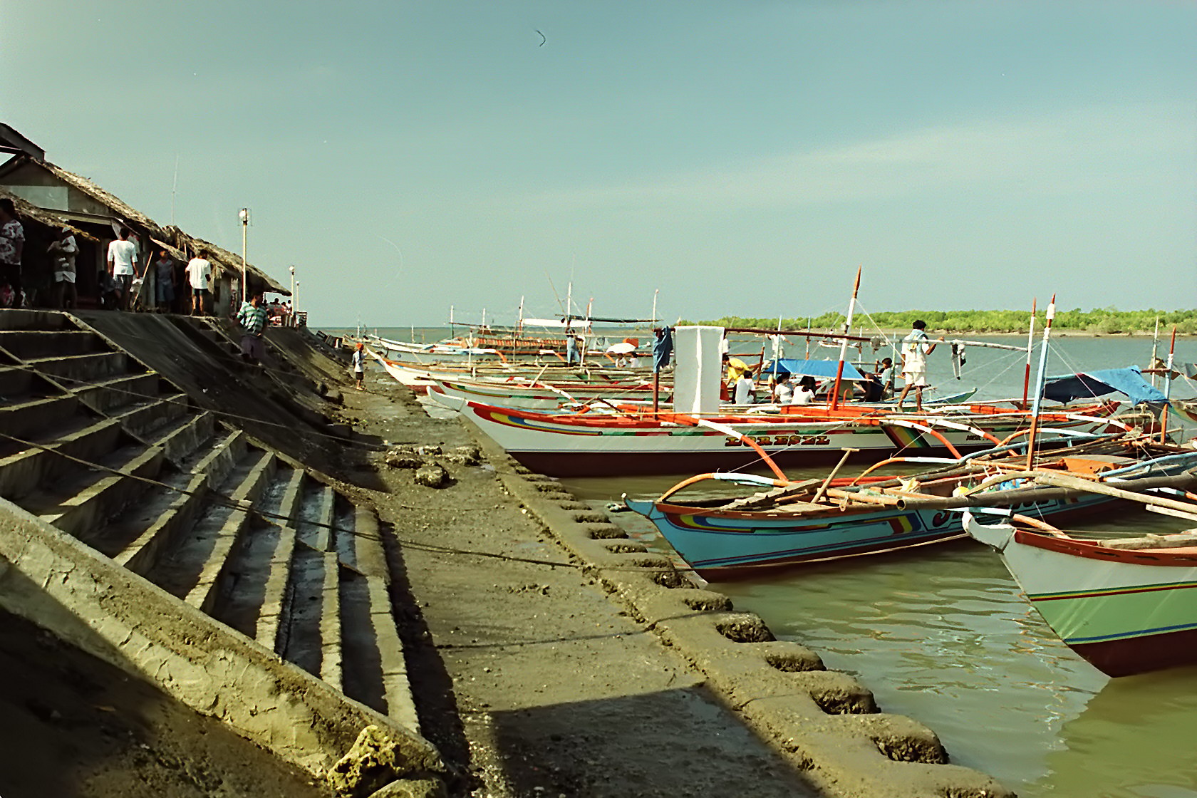
Donsol, officially the Municipality of Donsol, (Central Bikol: Banwaan kan Donsol; Tagalog: Bayan ng Donsol) is a municipality in the province of Sorsogon, Philippines. According to the 2020 census, it has a population of 50,281 people.[5]
Key Information
Donsol is 66 kilometres (41 mi) from Sorsogon City, 571 kilometres (355 mi) from Manila, and 94 kilometres (58 mi) from Legazpi.
Geography
[edit]Barangays
[edit]Donsol is politically subdivided into 51 barangays. Each barangay consists of puroks and some have sitios.
- Alin
- Awaii (Poblacion)
- Banban
- Bandi
- Banuang Gurang
- Baras
- Bayawas
- Bororan Barangay 1 (Poblacion)
- Cabugao
- Central Barangay 2 (Poblacion)
- Cristo
- Dancalan
- De Vera
- Gimagaan
- Girawan
- Gogon
- Gura
- Juan Adre
- Lourdes
- Mabini
- Malapoc
- Malinao
- Market Site Barangay 3 (Poblacion)
- New Maguisa
- Ogod (Crossing)
- Old Maguisa
- Orange
- Pangpang
- Parina
- Pawala
- Pinamanaan
- Poso Pob. (Barangay 5)
- Punta Waling-Waling Dalisay (Poblacion)
- Rawis (Poblacion Brgy)
- San Antonio
- San Isidro
- San Jose
- San Rafael
- San Ramon
- San Vicente
- Santa Cruz (Itunggan)
- Sevilla
- Sibago
- Suguian
- Tagbac
- Tinanogan
- Tongdol
- Tres Marias (Poblacion Brgy)
- Tuba
- Tupas
- Vinisitahan
Climate
[edit]| Climate data for Donsol, Sorsogon | |||||||||||||
|---|---|---|---|---|---|---|---|---|---|---|---|---|---|
| Month | Jan | Feb | Mar | Apr | May | Jun | Jul | Aug | Sep | Oct | Nov | Dec | Year |
| Mean daily maximum °C (°F) | 27 (81) |
28 (82) |
29 (84) |
31 (88) |
31 (88) |
30 (86) |
29 (84) |
29 (84) |
29 (84) |
29 (84) |
29 (84) |
28 (82) |
29 (84) |
| Mean daily minimum °C (°F) | 22 (72) |
21 (70) |
22 (72) |
23 (73) |
24 (75) |
25 (77) |
25 (77) |
25 (77) |
25 (77) |
24 (75) |
23 (73) |
23 (73) |
24 (74) |
| Average precipitation mm (inches) | 65 (2.6) |
44 (1.7) |
42 (1.7) |
39 (1.5) |
87 (3.4) |
150 (5.9) |
184 (7.2) |
153 (6.0) |
163 (6.4) |
154 (6.1) |
127 (5.0) |
100 (3.9) |
1,308 (51.4) |
| Average rainy days | 13.9 | 9.2 | 11.0 | 12.5 | 19.6 | 24.3 | 26.5 | 25.0 | 25.5 | 24.4 | 19.4 | 15.1 | 226.4 |
| Source: Meteoblue[6] | |||||||||||||
Demographics
[edit]| Year | Pop. | ±% p.a. |
|---|---|---|
| 1903 | 6,685 | — |
| 1918 | 10,656 | +3.16% |
| 1939 | 18,050 | +2.54% |
| 1948 | 20,681 | +1.52% |
| 1960 | 23,703 | +1.14% |
| 1970 | 30,548 | +2.57% |
| 1975 | 32,310 | +1.13% |
| 1980 | 33,785 | +0.90% |
| 1990 | 33,159 | −0.19% |
| 1995 | 36,013 | +1.56% |
| 2000 | 39,995 | +2.27% |
| 2007 | 43,996 | +1.32% |
| 2010 | 47,563 | +2.88% |
| 2015 | 49,711 | +0.84% |
| 2020 | 50,281 | +0.24% |
| 2024 | 51,781 | +0.71% |
| Source: Philippine Statistics Authority[7][8][9][10][11] | ||
Language
[edit]The majority of the population speak Eastern Miraya, an Albay Bikol language of Inland Bikol group of languages. The language is also spoken in four towns of Albay and some parts of Pilar and Castilla, Sorsogon. It is mutually intelligible with Western Miraya. People of Donsol can also speak and understand Tagalog or Filipino, the national language, and English.
Religion
[edit]The majority of the people adhere to Catholicism and each barangay has a patron saint and fiestas are held annually. Iglesia ni Cristo is the second largest religion of the population and has several local congregations in the municipality.
Economy
[edit]Poverty incidence of Donsol
10
20
30
40
50
60
70
2000
65.14 2003
68.73 2006
54.60 2009
47.30 2012
44.13 2015
46.80 2018
37.10 2021
37.54 Source: Philippine Statistics Authority[12][13][14][15][16][17][18][19] |
Tourism
[edit]Whale shark viewing
[edit]
Swimming with whale sharks, locally known as butanding, was featured as the Best Animal Encounter in Asia by Time magazine in 2004. Whale sharks can be seen between November and June, with presence peaking between February and May.
The presence of whale sharks in Donsol was known to residents for more than 100 years, but the locals believed these gentle giants were dangerous. This changed when on December 26, 1997, a group of scuba divers led by Romir Aglugub – a PADI diving instructor, discovered their presence, interacted with, and came in contact with the whale sharks. Even the members of Aglugub's diving group of Romir were having second thoughts about whether the fish is docile, until Aglugub led the way into the water and came in contact with the whale sharks. Copy of video footage taken by the group was passed on to the media and the WWF-Philippines. By 1998, Donsol became known as the “Whale Shark Capital of the World”.
Interaction with the whale sharks is regulated by the local Department of Tourism (DOT) office. WWF guidelines are generally observed to protect the sharks. Rules include limiting the number of swimmers per boat to six, prohibiting scuba divers, and requiring staying farther than three meters from the sharks.
In recent years the number of male sharks has out-numbered female sharks by 20:1. Generally, the females that are seen are large mature adults in the 7m ~ 9m range. Increasing numbers of sharks show propeller marks on their backs. Anecdotal evidence from local fishermen suggests that prop strikes are from fishing boats in the off-season, rather than from tourist boats during the main February–June tourist season.
In 2006 five sharks were found dead on the surface of the water, within 30 miles of Donsol. They had all been shot at close range. One shark had 13 bullet wounds to the head. The locals blame this on commercial fishermen shooting the sharks if they are caught in their nets. Manta rays, which are also protected in the Philippines, are also over-fished and sold in local markets in the Sorsogon area.
Groups from Singapore, Hong Kong, Taiwan, and the Philippines make up the largest groups of visitors. Most tourists book guided tours with dive centers familiar with whale shark interaction.
Other attractions
[edit]Donsol has a night firefly tour and shrimp-catching night tour available all-year round. Donsol also is becoming the best jump-off and base for divers to the Manta Bowl and San Miguel Island in Ticao due to the existence of better tourist facilities. Diving in Donsol itself is not allowed. Donsol also is a trekking and biking site, due mainly to the abundance of hilly areas and fields.
References
[edit]- ^ Municipality of Donsol | (DILG)
- ^ "2015 Census of Population, Report No. 3 – Population, Land Area, and Population Density" (PDF). Philippine Statistics Authority. Quezon City, Philippines. August 2016. ISSN 0117-1453. Archived (PDF) from the original on May 25, 2021. Retrieved July 16, 2021.
- ^ "2024 Census of Population (POPCEN) Population Counts Declared Official by the President". Philippine Statistics Authority. 17 July 2025. Retrieved 18 July 2025.
- ^ "PSA Releases the 2021 City and Municipal Level Poverty Estimates". Philippine Statistics Authority. 2 April 2024. Retrieved 28 April 2024.
- ^ "2024 Census of Population (POPCEN) Population Counts Declared Official by the President". Philippine Statistics Authority. 17 July 2025. Retrieved 18 July 2025.
- ^ "Donsol, Sorsogon : Average Temperatures and Rainfall". Meteoblue. Retrieved 29 December 2018.
- ^ "2024 Census of Population (POPCEN) Population Counts Declared Official by the President". Philippine Statistics Authority. 17 July 2025. Retrieved 18 July 2025.
- ^ Census of Population (2015). "Region V (Bicol Region)". Total Population by Province, City, Municipality and Barangay. Philippine Statistics Authority. Retrieved 20 June 2016.
- ^ Census of Population and Housing (2010). "Region V (Bicol Region)" (PDF). Total Population by Province, City, Municipality and Barangay. National Statistics Office. Retrieved 29 June 2016.
- ^ Censuses of Population (1903–2007). "Region V (Bicol Region)". Table 1. Population Enumerated in Various Censuses by Province/Highly Urbanized City: 1903 to 2007. National Statistics Office.
- ^ "Province of". Municipality Population Data. Local Water Utilities Administration Research Division. Retrieved 17 December 2016.
- ^ "Poverty incidence (PI):". Philippine Statistics Authority. Retrieved December 28, 2020.
- ^ "Estimation of Local Poverty in the Philippines" (PDF). Philippine Statistics Authority. 29 November 2005.
- ^ "2003 City and Municipal Level Poverty Estimates" (PDF). Philippine Statistics Authority. 23 March 2009.
- ^ "City and Municipal Level Poverty Estimates; 2006 and 2009" (PDF). Philippine Statistics Authority. 3 August 2012.
- ^ "2012 Municipal and City Level Poverty Estimates" (PDF). Philippine Statistics Authority. 31 May 2016.
- ^ "Municipal and City Level Small Area Poverty Estimates; 2009, 2012 and 2015". Philippine Statistics Authority. 10 July 2019.
- ^ "PSA Releases the 2018 Municipal and City Level Poverty Estimates". Philippine Statistics Authority. 15 December 2021. Retrieved 22 January 2022.
- ^ "PSA Releases the 2021 City and Municipal Level Poverty Estimates". Philippine Statistics Authority. 2 April 2024. Retrieved 28 April 2024.
External links
[edit]Donsol
View on GrokipediaHistory
Etymology and founding
The name Donsol derives from the Bikol term donsolan, meaning "anvil," reflecting the area's historical prominence as a center for skilled blacksmithing during the Spanish colonial period.[1] This etymology is tied to the production of metal implements such as machetes, knives, and bolos, which were essential for local agriculture, fishing, and trade. Archaeological evidence supporting this connection emerged in 1996 when the National Museum of the Philippines excavated remains of a metalworks factory and shipyard in Barangay Dancalan, confirming Donsol's role in supporting the Manila-Acapulco galleon trade through shipbuilding and repair activities.[3] Donsol originated as a barrio of Quipia (present-day Jovellar in Albay province) in the 17th century, with early inhabitants engaging in fishing and farming amid the Bicol region's coastal landscape.[1] It was established as an independent parish in 1668 under Franciscan missionary influence, marking the formal introduction of Christianity and administrative separation from its parent settlement.[1] By 1800, Donsol was officially constituted as a pueblo civil (civil town) within the province of Albay, gaining greater autonomy in governance and ecclesiastical affairs.[1] In 1831, the townsite was relocated from the old center of Banuang Gurang to its current location in Barra on July 11, driven by economic advantages such as proximity to fertile lands and navigable waterways that facilitated trade and resource extraction.[1] This move solidified Donsol's development as a self-sustaining community, laying the foundation for its evolution into a key municipality in Sorsogon province after the latter's separation from Albay in 1894.[1]Colonial era to independence
During the Spanish colonial period, Donsol served as a significant site for maritime activities supporting the Manila-Acapulco galleon trade. The Donsol astillero, located along the lower reaches of the Donsol River, functioned as a key shipyard for constructing, repairing galleons, and smelting metals, utilizing local hardwood forests, skilled boat-builders, and river transport for materials.[6] Artifacts such as iron nails, copper sheathing, lead objects, Chinese and European ceramics, over 400 kg of slag, and a 3-meter anchor uncovered after a 1950s flood attest to its role in the colonial economy, with the site reclaimed from mangroves covering approximately 11,000 square meters.[6] Franciscan missionaries established Donsol as an independent parish in 1668, spreading Catholicism from earlier bases in the region and integrating it into the ecclesiastical structure of what would become Sorsogon province.[7] As Spanish rule waned amid the Philippine Revolution, Donsol transitioned to American control following the Spanish-American War of 1898 and the subsequent Philippine-American War. In early 1900, local revolutionary forces led by Father Felipe Orense of Donsol resisted the American occupation, though organized opposition in the area weakened by February 1901 as part of broader pacification efforts in Sorsogon.[8] The American colonial administration formalized local governance, with Donsol operating as a municipality by the early 1900s, emphasizing infrastructure and public health amid challenges like the Asiatic cholera epidemic of 1902–1903, which originated as a principal outbreak point in Donsol and claimed hundreds of lives province-wide before being contained through a mobile 60-bed hospital.[8] The period of American rule in Donsol, like the rest of the Philippines, was interrupted by Japanese occupation from 1942 to 1945 during World War II, marked by local hardships and guerrilla resistance. Full independence was achieved on July 4, 1946, when the United States granted sovereignty to the Philippine Commonwealth, ending formal colonial oversight and integrating Donsol into the newly sovereign nation as a municipality in Sorsogon province.[9]Modern developments
In the late 20th century, Donsol transitioned from a primarily agrarian and fishing-based economy to a prominent ecotourism destination, driven by the discovery of seasonal whale shark aggregations. Whale sharks, locally known as butanding, began attracting attention in the early 1990s following a notable plankton bloom in 1998 that drew large numbers to Donsol Bay. This prompted the Sorsogon Provincial Tourism Council to initiate community-based ecotourism efforts, marking a pivotal shift. In response to reports of whale shark killings that year, the Philippine government issued Fisheries Administrative Order 193, imposing a nationwide ban on hunting the species.[10][11] By 2000, the World Wildlife Fund (WWF)-Philippines, in collaboration with the United Nations Development Programme (UNDP), formalized the Donsol Butanding Ecotourism Management Plan, establishing strict guidelines such as maintaining a 3-meter distance from the sharks' heads and limiting swimmers to six per animal to minimize disturbance. These measures, enforced through mandatory tourist orientations and trained local boat operators, fostered sustainable practices and empowered communities by creating jobs in guiding, transportation, and hospitality. By 2005, the program generated approximately USD 623,000 in revenue over the peak season (February to May), supporting around 300 local jobs and drawing about 7,000 foreign visitors, which helped elevate Donsol from a third-class to a first-class municipality.[10][12] The 2010s brought challenges, including a decline in whale shark sightings starting around 2015, attributed to environmental factors like overfishing and climate change, which reduced annual visitors from over 100,000 in peak years to fewer encounters. Efforts to diversify tourism, such as promoting nearby dive sites like Manta Bowl, and strengthening conservation through partnerships with the Department of Tourism sustained the local economy. Recovery signs emerged in the 2020s; by 2020, 19 new individuals were identified, and in the 2025 season, 55 sightings were recorded, including 24 new and 31 returning sharks, totaling 771 unique individuals since 2007. Recent initiatives like the 2024 "Buhay Donsol" program emphasize community-led sustainability, interpretive education, and alternative livelihoods to address ongoing threats such as bycatch in tuna fisheries.[11][12][13]Geography
Location and topography
Donsol is a coastal municipality in the province of Sorsogon, within the Bicol Region (Region V) of the Philippines on the island of Luzon.[4] It lies along the western coast of the province, bordering the Burias Pass to the west, which separates it from Burias Island in Masbate.[14] The municipal center is situated at coordinates 12° 54' North latitude and 123° 36' East longitude, with an elevation of 5.6 meters above sea level.[4] Sorsogon province itself occupies the southeastern tip of the Bicol Peninsula, bounded by Albay to the north, the Pacific Ocean to the east, and Ticao Pass to the southwest.[15] The topography of Donsol features a combination of low-lying coastal plains and inland hilly, rolling terrain, contributing to its vulnerability to flooding in lower areas.[16] Elevations within the Donsol River basin, which encompasses much of the municipality, range from a minimum of 52.66 meters to a maximum of 447.71 meters above sea level.[16] The landscape gently slopes from interior hills toward the shoreline, including brushlands, sparse mangroves near the river mouth, and developed fishponds along the coast.[16] The Donsol River, with a drainage area of 396 square kilometers and a main stem length of 24.8 kilometers, and the nearby Ogod River, shape the local terrain and support coastal ecosystems.[14] The municipality covers a total land area of 156.20 square kilometers, representing 7.37% of Sorsogon's provincial area.[4]Administrative divisions
Donsol, a municipality in the province of Sorsogon in the Philippines, is politically subdivided into 51 barangays, which function as the smallest administrative units in the country.[1][4] These barangays encompass both rural and urban areas, with several designated as part of the poblacion or town center, including Awaii (Poblacion), Bororan Barangay 1 (Poblacion), Central Barangay 2 (Poblacion), Market Site Barangay 3 (Poblacion), Poso Poblacion (Barangay 5), and Punta Waling-Waling (Poblacion).[1] According to the 2024 Census of Population and Housing by the Philippine Statistics Authority, Donsol's total population is 51,781, reflecting a mix of coastal, inland, and riverside communities that support the municipality's economy centered on fishing, agriculture, and ecotourism.[17][4] As of the 2020 census, the largest barangay by population was Ogod, with 4,189 inhabitants, known for its role as a key accessibility point near the Donsol River and proximity to tourist sites.[4] Other significant barangays include Dancalan (3,498 residents), a coastal area vital for fishing activities, and Vinisitahan (2,564 residents), which features agricultural lands and community infrastructure.[4] Smaller barangays, such as Pawala and Cabugao, each with populations under 500, highlight the rural character of much of Donsol, where communities rely on subsistence farming and seasonal livelihoods.[4] The administrative structure ensures local governance at the barangay level, with each led by an elected captain and council responsible for community services, dispute resolution, and development initiatives aligned with municipal priorities like environmental conservation.[1]Climate
Donsol, located in the Bicol Region of the Philippines, experiences a tropical rainforest climate (Köppen classification Af), characterized by high temperatures, elevated humidity, and abundant rainfall throughout the year. The municipality's proximity to the Pacific Ocean influences its weather patterns, resulting in a consistently warm environment with minimal seasonal temperature variation. Average annual temperatures hover around 29.3°C (84.7°F), with highs reaching up to 30.6°C (87.1°F) and lows rarely dropping below 26.9°C (80.5°F). Humidity levels average 86.5%, contributing to a muggy feel year-round.[18] The region features a pronounced wet season from June to November, driven by the southwest monsoon (habagat), which brings heavy downpours and increased cloud cover, while the dry season spans December to May, influenced by the northeast monsoon (amihan). Rainfall totals approximately 3,000–4,000 mm annually, with the wettest months occurring between July and December; December records the highest precipitation at around 443 mm, followed closely by July at 465 mm. In contrast, the driest period is March to May, with April seeing only about 65–84 mm of rain. Rainy days number roughly 216 per year, or 59% of the time, often leading to short but intense showers rather than prolonged storms.[18][19] Temperature peaks in May, the warmest month, with averages of 32.5°C (90.5°F), while February marks the coolest at 25.4°C (77.7°F). Sunshine hours vary significantly, with up to 195 hours in April during the dry season and as few as 60 hours in July amid frequent rains. These patterns make Donsol's climate ideal for tourism activities like whale shark watching, which peaks during the calmer, drier months of February to May, though visitors should prepare for sudden tropical showers even then.[18][19][20]Monthly Climate Averages for Donsol
The following table summarizes key monthly climate data based on historical records.| Month | Avg. High (°C) | Avg. Low (°C) | Avg. Temp. (°C) | Rainfall (mm) | Rainy Days | Sunshine Hours |
|---|---|---|---|---|---|---|
| January | 28.2 | 25.7 | 25.0 | 199–249 | 10–24 | 102 |
| February | 28.0 | 24.0 | 25.4 | 92 | 6 | 151 |
| March | 29.0 | 24.0 | 26.0 | 69 | 6 | 187 |
| April | 30.0 | 25.0 | 27.0 | 65–84 | 6 | 195 |
| May | 32.5 | 28.0 | 28.0 | 110–163 | 13–15 | 177 |
| June | 30.0 | 26.0 | 28.0 | 338 | 20 | 102 |
| July | 29.0 | 26.0 | 28.0 | 443–465 | 24 | 60 |
| August | 29.0 | 26.0 | 28.0 | 363 | 20 | 78 |
| September | 29.0 | 26.0 | 27.0 | 410 | 22 | 73 |
| October | 29.0 | 25.0 | 27.0 | 294 | 17 | 100 |
| November | 29.0 | 25.0 | 27.0 | 140 | 12 | 132 |
| December | 29.4 | 26.7 | 26.0 | 228–443 | 12–26 | 121 |
Demographics
Population trends
The population of Donsol has exhibited steady long-term growth since the early 20th century, increasing from 6,685 inhabitants in the 1903 census to 50,281 in the 2020 census, representing a net gain of 43,596 people over 117 years.[4] This expansion reflects broader demographic patterns in rural Philippine municipalities, with average annual population growth rates (APGR) varying significantly across periods, peaking at 2.99% between 1903 and 1918 before moderating in later decades.[4] Historical census data illustrate phases of acceleration and deceleration. Early growth was robust, driven by post-colonial recovery, with the population reaching 10,656 by 1918 and 18,050 by 1939 (APGR of 2.67% from 1918–1939). Post-World War II, numbers rose to 20,681 in 1948 and 23,703 in 1960 (APGR 1.21%), followed by a stronger surge to 30,548 in 1970 (APGR 2.51%). However, the 1970s and 1980s saw more modest increases, with 32,310 in 1975 (APGR 1.13%) and 33,785 in 1980 (APGR 0.90%), before a rare contraction to 33,159 in 1990 (APGR -0.19%).[4] Growth resumed in the late 20th and early 21st centuries, aligning with national trends of urbanization and economic diversification. The population climbed to 36,013 in 1995 (APGR 1.56%), 39,995 in 2000 (APGR 2.27%), 43,996 in 2007 (APGR 1.32%), and 47,563 in 2010 (APGR 2.88%). Recent censuses indicate a slowdown, with 49,711 recorded in 2015 (APGR 0.84%) and only 570 additional residents by 2020 (APGR 0.24%), suggesting stabilizing demographic pressures such as out-migration to urban centers or declining fertility rates common in Bicol Region municipalities.[4]| Census Year | Population | APGR (Previous Period) |
|---|---|---|
| 1903 | 6,685 | — |
| 1918 | 10,656 | 2.99% |
| 1939 | 18,050 | 2.67% |
| 1948 | 20,681 | 1.41% |
| 1960 | 23,703 | 1.21% |
| 1970 | 30,548 | 2.51% |
| 1975 | 32,310 | 1.13% |
| 1980 | 33,785 | 0.90% |
| 1990 | 33,159 | -0.19% |
| 1995 | 36,013 | 1.56% |
| 2000 | 39,995 | 2.27% |
| 2007 | 43,996 | 1.32% |
| 2010 | 47,563 | 2.88% |
| 2015 | 49,711 | 0.84% |
| 2020 | 50,281 | 0.24% |

