
Community hub
Recent from talks
Contribute something
Nothing was collected or created yet.
Kennesaw, Georgia
View on Wikipedia
Kennesaw is a suburban city northwest of Atlanta in Cobb County, Georgia, United States, located within the greater Atlanta metropolitan area. Known from its original settlement in the 1830s until 1887 as Big Shanty, it became Kennesaw under an 1887 charter. According to the 2020 census, Kennesaw had a population of 33,036, a 10.9% increase in population over the preceding decade.[4] Kennesaw has an important place in railroad history. During the Civil War, Kennesaw was the staging ground for the Great Locomotive Chase on April 12, 1862. Kennesaw is home to Kennesaw State University, an R2 research institution and the third-largest public university in the state of Georgia.
Key Information


Etymology
[edit]The name "Kennesaw" is derived from the Cherokee word Ganisahv (Cherokee spelling: ᎦᏂᏌᎲ), meaning 'cemetery' or 'burial ground'.[5]
History
[edit]As the Western and Atlantic Railroad was being built in the late 1830s, shanty towns arose to house the workers. These were near a big spring. A grade up from the Etowah River became known as "the big grade to the shanties", then "Big Shanty Grade", and finally "Big Shanty". It was officially incorporated as the city of Kennsaw in 1887.[6]
Civil War
[edit]Camp MacDonald, a training camp, was located there from 1861 to 1863.[7]
During the Civil War, Big Shanty was the site of major fighting in the Battle of Kennesaw Mountain, part of the larger Atlanta campaign. Kennesaw Mountain National Battlefield Park,[8] located southeast of the city limits, now contains many of these historic areas. Much of the surrounding land has been developed, and many of the buried artifacts have been searched for and taken by people with metal detectors.[9] Some artifacts of the Civil War are still on display in the visitor center of Kennesaw Mountain.[10]
Later history
[edit]L. C. Chalker purchased a 1.25-acre (0.51 ha) tract of land adjacent to the Kennesaw Cemetery from J.W. Ellis in 1934, which was sold for burial purposes. Chalker purchased another 1 acre (0.40 ha) adjacent to the first parcel in 1948, which was also to be used for a cemetery. The Chalker family managed these portions of the cemetery until they were sold to the City of Kennesaw in the mid-1950s. The earliest known burial is the infant Lucius B. Summers, who was interred in 1863. Other grave markers date as far back as the 1860s to the 1890s. Civil War veterans are buried here. The Kennesaw Cemetery is still in use.[11]
In March 2004, First Lady Laura Bush designated Kennesaw a Preserve America Community.[12]
Geography
[edit]Kennesaw is located in northwestern Cobb County, bordered by the city of Acworth to the northwest. Kennesaw Mountain is located southeast of the city limits in the battlefield park. Its summit is the highest point in the Atlanta metro area, at an elevation of 1,808 feet (551 m) above sea level. The city was renamed for the mountain.
U.S. Route 41 and State Route 3 pass through the city as Cobb Parkway, leading southeast 7 miles (11 km) to Marietta and northwest 17 miles (27 km) to Cartersville. Interstate 75 passes just northeast of the city limits, with access from exits 269, 271, and 273. Via I-75, downtown Atlanta is 27 miles (43 km) to the southeast, and Chattanooga, Tennessee, is 94 miles (151 km) northwest.
The iconic peaks of Kennesaw Mountain are visible from the bridge over Interstate 75 that crosses over the city limits of Kennesaw.[13]
According to the United States Census Bureau, Kennesaw has a total area of 9.5 square miles (24.7 km2), of which 9.4 square miles (24.4 km2) is land and 0.12 square miles (0.3 km2), or 1.08%, is water.[14]
Climate
[edit]Kennesaw has a humid subtropical climate (Köppen climate classification: Cfa). On November 22, 1992, an F-4 tornado caused 34 injuries.[citation needed]
| Climate data for Kennesaw, Georgia | |||||||||||||
|---|---|---|---|---|---|---|---|---|---|---|---|---|---|
| Month | Jan | Feb | Mar | Apr | May | Jun | Jul | Aug | Sep | Oct | Nov | Dec | Year |
| Record high °F (°C) | 80 (27) |
81 (27) |
89 (32) |
93 (34) |
96 (36) |
101 (38) |
104 (40) |
104 (40) |
99 (37) |
92 (33) |
86 (30) |
80 (27) |
104 (40) |
| Mean daily maximum °F (°C) | 52 (11) |
56 (13) |
64 (18) |
73 (23) |
80 (27) |
87 (31) |
89 (32) |
88 (31) |
83 (28) |
73 (23) |
64 (18) |
54 (12) |
72 (22) |
| Mean daily minimum °F (°C) | 30 (−1) |
33 (1) |
39 (4) |
46 (8) |
55 (13) |
64 (18) |
68 (20) |
67 (19) |
60 (16) |
48 (9) |
39 (4) |
32 (0) |
48 (9) |
| Record low °F (°C) | −12 (−24) |
−2 (−19) |
7 (−14) |
21 (−6) |
32 (0) |
40 (4) |
50 (10) |
48 (9) |
30 (−1) |
22 (−6) |
9 (−13) |
−4 (−20) |
−12 (−24) |
| Average precipitation inches (mm) | 4.86 (123) |
5.36 (136) |
5.07 (129) |
3.93 (100) |
4.12 (105) |
4.07 (103) |
5.10 (130) |
4.35 (110) |
4.10 (104) |
3.42 (87) |
4.30 (109) |
4.49 (114) |
54.63 (1,388) |
| Source: [15] | |||||||||||||
Demographics
[edit]| Census | Pop. | Note | %± |
|---|---|---|---|
| 1880 | 244 | — | |
| 1890 | 168 | −31.1% | |
| 1900 | 320 | 90.5% | |
| 1910 | 573 | 79.1% | |
| 1920 | 467 | −18.5% | |
| 1930 | 426 | −8.8% | |
| 1940 | 436 | 2.3% | |
| 1950 | 564 | 29.4% | |
| 1960 | 1,507 | 167.2% | |
| 1970 | 3,548 | 135.4% | |
| 1980 | 5,095 | 43.6% | |
| 1990 | 8,936 | 75.4% | |
| 2000 | 21,675 | 142.6% | |
| 2010 | 29,783 | 37.4% | |
| 2020 | 33,036 | 10.9% | |
| 2024 (est.) | 37,740 | 14.2% | |
| U.S. Decennial Census[16] 1850-1870[17] 1870-1880[18] 1890-1910[19] 1920-1930[20] 1940[21] 1950[22] 1960[23] 1970[24] 1980[25] 1990[26] 2000[27] 2010[28] | |||
2020 census
[edit]| Race | Num. | Perc. |
|---|---|---|
| White (non-Hispanic) | 17,102 | 51.77% |
| Black or African American (non-Hispanic) | 7,848 | 23.76% |
| Native American | 67 | 0.2% |
| Asian | 1,626 | 4.92% |
| Pacific Islander | 17 | 0.05% |
| Other/Mixed | 2,119 | 6.41% |
| Hispanic or Latino | 4,257 | 12.89% |
As of the 2020 United States census, there were 33,036 people, 12,803 households, and 8,250 families residing in the city.
2010 census
[edit]As of the census[2] of 2010, there were 29,783 people, 11,413 households, and 7,375 families residing in the city. There were 12,328 housing units at an average density of 1,027.3 per square mile (396.6/km2). The racial makeup of the city was 58.9% White, 22.3% Black, 10.8% Hispanic or Latino of any race, 5.3% Asian, 0.4% Native American, 0.02% Pacific Islander (U.S. Census), 4.7% of other races, and 3.0% non-Hispanic mixed of two or more races.
There were 11,413 households, out of which 38.1% had children under the age of 18 living with them, 45.0% were married couples living together, 15.2% had a female householder with no husband present, and 35.4% were non-families. Of all households, 26.8% were made up of individuals, and 6.4% had someone living alone who was 65 years of age or older. The average household size was 2.59 and the average family size was 3.18.
In the city, the population was spread out, with 27.0% under the age of 18, 10.6% from 18 to 24, 33.2% from 25 to 44, 21.8% from 45 to 64, and 7.3% who were 65 years of age or older. The median age was 32 years. For every 100 females, there were 95.6 males. For every 100 females age 18 and over, there were 89.7 males.
Economy
[edit]Personal income
[edit]The median income for a household in the city was $61,355 and the median income for a family was $75,465. Males had a median income of $46,953, versus $42,809 for females. The per capita income for the city was $27,165. About 8.2% of families and 11.1% of the population were below the poverty line, including 13.1% of those under age 18 and 13.3% of those age 65 or over.
Tourism
[edit]Several festivals are held annually. Every April the annual Big Shanty Festival displays over 200 arts and crafts booths along with 20 food booths downtown featuring several local businesses and entrepreneurs. Over 60,000 people from around North Georgia attend the festival. The festival begins with a parade through downtown.[30]
Government
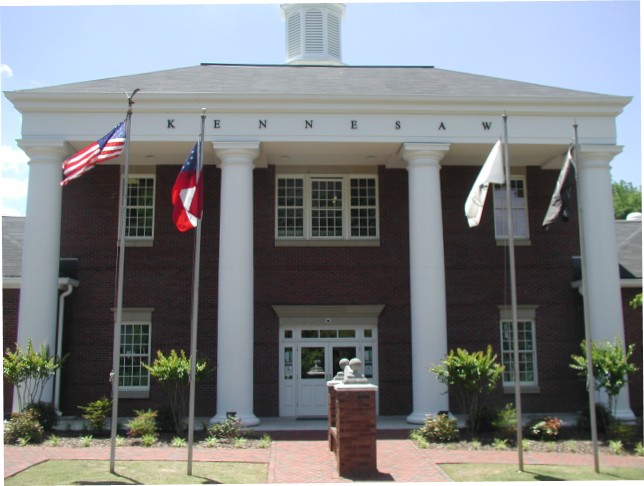
[edit]The city hall[31] is located downtown, just off Main Street (old U.S. 41 and State Route 3, later State Route 293). It contains the offices of mayor and city council, a basement jail, a municipal 9-1-1 call center and other offices. It is the public-safety answering point for the city of Kennesaw and the neighboring city of Acworth, and dispatches the separate police departments of both cities. Calls for fire services are relayed to and dispatched from Cobb County's 911 center,[32] and serviced by the Cobb County Fire Department, as neither city has its own fire department.
Wireless Internet in city parks
[edit]In 2008, the city of Kennesaw awarded a bid to Digitel Wireless for the implementation of city wireless Internet. In March 2008, the city of Kennesaw announced the grand opening of four new wireless areas: Swift-Cantrell Park and Adams Park, and the train depot area across from the Southern Museum of Civil War and Locomotive History. The city has also provided Wi-Fi in the Ben Robertson Community Center.[33]
Crime statistics
[edit]In 2001, violent crime rates were about 60% below national and state rates. Property crime rates were from 46 to 56% below national and state rates. From 1999 to 2011, Kennesaw crime statistics reported that both property and violent crimes had decreased, though from 2003 to 2008 the trend in both violent and property crime rates slightly increased.[34] The increase in crime rate overall is attributed to the population growth rate of 37.41%. The population growth rate is much higher than the state average rate of 18.34% and is much higher than the national average rate of 9.71%.[35]
County services
[edit]The Cobb County Public Library System operates a Kennesaw branch library. The Cobb County Police Department serves unincorporated areas, including the Town Center Area Community Improvement District and Kennesaw State University (in addition to KSU's own police).
Gun law
[edit]Kennesaw is noted for its unique firearms legislation, passed in response to a handgun ban in Morton Grove, Illinois. In 1982 the city passed an ordinance [Sec 34-21]:[36]
(a) In order to provide for the emergency management of the city, and further in order to provide for and protect the safety, security and general welfare of the city and its inhabitants, every head of household residing in the city limits is required to maintain a firearm, together with ammunition therefore.
(b) Exempt from the effect of this section are those heads of households who suffer a physical or mental disability which would prohibit them from using such a firearm. Further exempt from the effect of this section are those heads of households who are paupers or who conscientiously oppose maintaining firearms as a result of beliefs or religious doctrine, or persons convicted of a felony.
A similar law was passed in 2000 in the city of Virgin, Utah, making it the second city in the United States to require residents to own guns.[37] Nelson, Georgia; Nucla, Colorado; and Gun Barrel City, Texas, also followed suit.[38]
Local attractions
[edit]
- Southern Museum of Civil War and Locomotive History
- Kennesaw Mountain National Battlefield Park consists of around 18 miles (29 km) of nature trails and historic Civil War battle sites.[39]
- The Kennesaw State University Bentley Rare Book Room and Archives[40]
Education
[edit]Public schools are operated by the Cobb County School District.
Elementary schools include Big Shanty Intermediate,[41] Bullard,[42] Chalker,[43] Hayes,[44] Kennesaw,[45] and Lewis.[46]
Middle schools include Awtrey,[47] Lost Mountain,[48] McClure,[49] Palmer,[50] and Pine Mountain.[51]
High schools include Harrison High School,[52] Kennesaw Mountain,[53] North Cobb,[54] and Kennesaw Charter Science & Math Academy.[55]
Private schools include Sunbrook Academy at Legacy Park,[56] Sunbrook Academy at Stilesboro, and Mount Paran Christian School.
Kennesaw State University is located near the city and is part of the University System of Georgia.
Sports
[edit]In 2016, the Atlanta Blaze of Major League Lacrosse spent their first year of play as an expansion franchise with home games at Fifth Third Bank Stadium on the campus of Kennesaw State University.[57] The team relocated in 2019.
Notable people
[edit]- Darvin Adams, Canadian football player[58]
- Caroline Cossey, English model[59]
- Jesse James Dupree, lead singer of rock band Jackyl[60]
- Yan Kaminsky, NHL left winger[61]
- Ron Lester, actor[62]
- Justin Fields, National Football League quarterback playing for the New York Jets[63]
- Suzanne Lambert, internet personality and comedian
- Payne Lindsey, documentary filmmaker and podcast host of Up and Vanished and Atlanta Monster[citation needed]
- Scott F. McAfee, judge on the Fulton County Superior Court and Georgia Inspector General from 2021 to 2023[64]
- Sean O'Pry, model[65]
- Mathew Pitsch, member of the Arkansas House of Representatives from Fort Smith from 2015 to 2019; former resident of Kennesaw[66]
- Dansby Swanson, infielder for the Chicago Cubs[67]
- Lucas Till, actor[68]
- Brian Voss, professional ten-pin bowler on the PBA Tour[69]
See also
[edit]References
[edit]- ^ "2020 U.S. Gazetteer Files". United States Census Bureau. Retrieved December 18, 2021.
- ^ a b "U.S. Census website". United States Census Bureau. Archived from the original on December 27, 1996. Retrieved January 31, 2008.
- ^ "US Board on Geographic Names". United States Geological Survey. October 25, 2007. Archived from the original on February 12, 2012. Retrieved January 31, 2008.
- ^ "Explore Census Data". data.census.gov. Retrieved August 23, 2023.
- ^ Martin, Christopher; King, David (2014). "Digital Commons Kennesaw". 2014 Faculty Bookshelf. KSU.edu. Archived from the original on February 8, 2015. Retrieved February 8, 2015.
- ^ "How Big Shanty Got Its Name". Trade Day News. Kennesaw, Georgia. April 23–24, 1977. p. 9.
- ^ "Georgia Forts: page 7". www.northamericanforts.com. Archived from the original on November 29, 2012. Retrieved January 7, 2013.
- ^ "Kennesaw Mountain National Battlefield Park – Kennesaw Mountain National Battlefield Park". U.S. National Park Service. Archived from the original on October 13, 2010. Retrieved July 12, 2012.
- ^ "Relic Hunting and Metal Detecting - Kennesaw Mountain National Battlefield Park (U.S. National Park Service)". U.S. National Park Service. Retrieved October 29, 2020.
- ^ "Basic Information - Kennesaw Mountain National Battlefield Park". U.S. National Park Service. Retrieved October 29, 2020.
- ^ Zavattaro, Staci M. (June 1, 2020), "Cemetery Potpourri", City Sextons, New York: Routledge, pp. 78–92, doi:10.4324/9780429285967-7, ISBN 978-0-429-28596-7, S2CID 242425155, retrieved October 29, 2020
- ^ "Preserve America – Explore and Enjoy Our Heritage". Preserveamerica.gov. July 3, 2012. Archived from the original on July 14, 2012. Retrieved July 12, 2012.
- ^ "Bridge over I-75 - News | KSU". news.kennesaw.edu. Retrieved October 29, 2020.
- ^ "Geographic Identifiers: 2010 Demographic Profile Data (G001): Kennesaw city, Georgia". U.S. Census Bureau, American Factfinder. Archived from the original on February 12, 2020. Retrieved July 29, 2014.
- ^ "Monthly Averages for Kennesaw, GA (30152)". Archived from the original on May 3, 2014. Retrieved May 2, 2012.
- ^ "Decennial Census of Population and Housing by Decade". United States Census Bureau.
- ^ "1870 Census of Population - Georgia - Population of Civil Divisions less than Counties" (PDF). United States Census Bureau. 1870.
- ^ "1880 Census of Population - Georgia - Population of Civil Divisions less than Counties" (PDF). United States Census Bureau. 1880.
- ^ "1910 Census of Population - Georgia" (PDF). United States Census Bureau. 1910. Archived from the original (PDF) on January 16, 2024.
- ^ "1930 Census of Population - Georgia" (PDF). United States Census Bureau. 1930. pp. 251–256.
- ^ "1940 Census of Population - Georgia" (PDF). United States Census Bureau. 1940.
- ^ "1950 Census of Population - Georgia" (PDF). United States Census Bureau. 1950.
- ^ "1960 Census of Population - Population of County Subdivisions - Georgia" (PDF). United States Census Bureau. 1960.
- ^ "1970 Census of Population - Population of County Subdivisions - Georgia" (PDF). United States Census Bureau. 1970.
- ^ "1980 Census of Population - Number of Inhabitants - Georgia" (PDF). United States Census Bureau. 1980.
- ^ "1990 Census of Population - Summary Social, Economic, and Housing Characteristics - Georgia" (PDF). United States Census Bureau. 1990.
- ^ "2000 Census of Population - General Population Characteristics - Georgia" (PDF). United States Census Bureau. 2000.
- ^ "2010 Census of Population - General Population Characteristics - Georgia" (PDF). United States Census Bureau. 2010.
- ^ "Explore Census Data". data.census.gov. Retrieved December 13, 2021.
- ^ "Big Shanty Festival | Kennesaw.com". Retrieved October 31, 2020.
- ^ (34°01′24″N 84°37′00″W / 34.0233°N 84.6167°W)
- ^ "911 Home Page". 911.cobbcountyga.gov. Archived from the original on April 11, 2012. Retrieved July 12, 2012.
- ^ "Kennesaw Wi-Fi". Kennesaw Wi-Fi. Archived from the original on August 9, 2012. Retrieved July 12, 2012.
- ^ "Kennesaw Crime Rate Report (Georgia)". Archived from the original on January 26, 2013. Retrieved April 2, 2013.
- ^ "Kennesaw Population and Races (Georgia)". Archived from the original on March 3, 2014. Retrieved February 28, 2014.
- ^ "Sec. 34-21. - Heads of households to maintain firearms". library.municode.com. Municode Library. Archived from the original on August 29, 2013. Retrieved February 6, 2013.
- ^ "Town in Utah Requires Owning Guns". ABC News. November 5, 2000. Retrieved July 14, 2022.
- ^ Finefrock, Amelia (December 20, 2018). "5 American Cities That Require You To Own A Gun". BrainCharm. Archived from the original on November 30, 2022. Retrieved February 17, 2021.
- ^ "USA Today Travel". Travel Tips - USA Today. Archived from the original on March 4, 2013. Retrieved July 11, 2012.
- ^ "About the Gallery | Archives, Rare Books & Records Management". Web.kennesaw.edu. Archived from the original on July 22, 2012. Retrieved July 12, 2012.
- ^ "Big Shanty Intermediate School". www.cobbk12.org. Archived from the original on August 18, 2015. Retrieved August 14, 2015.
- ^ "Bullard Elementary School". www.cobbk12.org. Archived from the original on August 11, 2015. Retrieved August 14, 2015.
- ^ "Chalker Elementary School". www.cobbk12.org. Archived from the original on August 28, 2015. Retrieved August 14, 2015.
- ^ "Hayes Elementary School". www.cobbk12.org. Archived from the original on August 23, 2015. Retrieved August 14, 2015.
- ^ "Kennesaw Elementary School". www.cobbk12.org. Archived from the original on August 15, 2015. Retrieved August 14, 2015.
- ^ "Lewis Elementary School". www.cobbk12.org. Archived from the original on August 22, 2015. Retrieved August 14, 2015.
- ^ "Awtrey Middle School". awtreyvikings.com. Archived from the original on August 12, 2015. Retrieved August 14, 2015.
- ^ "Lost Mountain Middle School". www.cobbk12.org. Archived from the original on August 13, 2015. Retrieved August 14, 2015.
- ^ "McClure Middle School- Home of the Mavericks". www.cobbk12.org. Archived from the original on August 10, 2015. Retrieved August 14, 2015.
- ^ "Palmer Middle School". www.cobbk12.org. Archived from the original on August 22, 2015. Retrieved August 14, 2015.
- ^ "Pine Mountain Middle School". www.cobbk12.org. Archived from the original on August 9, 2015. Retrieved August 14, 2015.
- ^ "Home - Harrison High School". www.harrisonhigh.org. Archived from the original on February 15, 2020. Retrieved May 7, 2020.
- ^ "Kennesaw Mountain High School". www.cobbk12.org. Archived from the original on August 18, 2015. Retrieved August 14, 2015.
- ^ "North Cobb High School". www.cobbk12.org. Archived from the original on August 9, 2015. Retrieved August 14, 2015.
- ^ ".: Kennesaw Charter". kennesawcharter.com. Archived from the original on August 11, 2015. Retrieved August 14, 2015.
- ^ "Daycare in Kennesaw, Georgia - Sunbrook Academy at Legacy Park". Archived from the original on September 24, 2015. Retrieved August 14, 2015.
- ^ "Major League Lacrosse". www.majorleaguelacrosse.com. Archived from the original on March 10, 2018. Retrieved March 9, 2018.
- ^ "My Most Memorable Game - Darvin Adams". Winnipeg Blue Bombers. March 1, 2021.
- ^ "How This Transgender Supermodel Found Love". www.advocate.com. November 3, 2016. Retrieved October 31, 2020.
- ^ Jesse James Dupree at AllMusic
- ^ "Error". thunderaaahockey.com. Archived from the original on November 3, 2013. Retrieved June 7, 2013.
- ^ "Ron Lester". IMDb.com, Inc. Archived from the original on August 5, 2016. Retrieved September 13, 2016.
- ^ "Steelers acquire Fields in trade with Bears". www.steelers.com. Retrieved March 21, 2024.
- ^ Mizelle, Shawna (August 15, 2023). "Who is Scott McAfee, the judge assigned to oversee Trump case in Georgia?". CNN. Retrieved August 16, 2023.
- ^ "Sean O'Pry - Model". Archived from the original on June 3, 2013. Retrieved June 7, 2013.
- ^ "Mathew W. Pitsch". intelius.com. Archived from the original on April 8, 2015. Retrieved April 9, 2015.
- ^ "Dansby Swanson Stats, Highlights, Bio | Gwinnett Stripers Stats". Gwinnett Stripers. Retrieved October 31, 2020.
- ^ "'MacGyver' reboot films at Austell restaurant". Marietta Daily Journal. January 17, 2017. Retrieved February 22, 2017.
- ^ "Exempt player bios at www.pba.com". Pba.com. Archived from the original on June 14, 2012. Retrieved July 12, 2012.
External links
[edit]Municipalities and communities of Cobb County, Georgia, United States | ||
|---|---|---|
| Cities |  | |
| CDPs | ||
| Unincorporated communities | ||
| Footnotes | ‡This populated place also has portions in an adjacent county or counties | |
|  | |||||
|
| ||||||
| International | |
|---|---|
| National | |
| Geographic | |
| Other | |
Kennesaw, Georgia
View on GrokipediaKennesaw is a suburban city in Cobb County, Georgia, United States, located in the northwestern part of the Atlanta metropolitan area, approximately 27 miles northwest of downtown Atlanta.[1][2] As of July 1, 2024, the population was estimated at 37,740.[3] Incorporated in 1887, the city is home to Kennesaw State University, a major public institution in the University System of Georgia, and lies adjacent to Kennesaw Mountain National Battlefield Park, preserving sites from the American Civil War.[4][5]
Originally known as Big Shanty, a railroad depot established in the 1830s, Kennesaw played a pivotal role in Civil War history as the origin point of the Great Locomotive Chase in 1862, where Union spies attempted to disrupt Confederate rail lines by commandeering the locomotive The General.[4] The city attracted national notice in 1982 when its council unanimously passed an ordinance mandating that every head of household maintain a firearm, together with proper ammunition, in their residence—enacted as a symbolic counter to restrictive gun laws elsewhere, with exemptions for those unable to own weapons and no recorded prosecutions for non-compliance.[4] Today, Kennesaw balances its historical heritage with modern suburban growth, featuring a vibrant downtown, parks, and proximity to major employment centers in the Atlanta region.[2]
Geography
Location and Topography
Kennesaw is located in Cobb County in northwestern Georgia, approximately 25 miles (40 km) northwest of downtown Atlanta within the Atlanta metropolitan area.[6] The city's geographic coordinates are roughly 34°1′N 84°37′W.[7] It occupies a total area of 9.83 square miles (25.46 km²), with 9.71 square miles (25.16 km²) consisting of land and 0.12 square miles (0.31 km²) of water.[8] The terrain features the rolling hills characteristic of the Piedmont physiographic province, with an average elevation of about 1,089 feet (332 m) above sea level. Kennesaw is adjacent to Kennesaw Mountain National Battlefield Park, where the prominent Kennesaw Mountain rises to 1,808 feet (551 m), the highest elevation in the Atlanta metropolitan region and influencing local drainage patterns toward the Etowah and Chattahoochee River basins.[9] This topography shapes the urban layout, with development concentrated along valleys and lower slopes to accommodate residential and commercial zones while preserving steeper areas.[10] Major transportation access includes Interstate 75, which traverses the city, and Interstate 575, which branches northward from I-75 near the city's center, enabling efficient commuter links to Atlanta and regional destinations.[11] Exits such as 271 provide direct connections to local roads like Chastain Road, supporting suburban growth patterns.[12]Climate
Kennesaw experiences a humid subtropical climate (Köppen classification Cfa), featuring hot, humid summers and mild winters with no prolonged cold spells.[13] Average annual precipitation totals approximately 53 inches, distributed relatively evenly across the year, with slightly higher amounts in summer due to convective thunderstorms. The hottest month is July, when daily highs average 87°F and lows 71°F, while January sees average lows around 34°F, with highs typically in the upper 50s°F.[13] Snowfall is minimal, averaging about 2 inches annually, and extreme temperatures rarely drop below 22°F or exceed 94°F. The region is prone to severe thunderstorms, especially from March to June, driven by the collision of warm, moist Gulf air with cooler fronts.[14] Tornadoes occur occasionally, with north Georgia's inland position conferring a lower overall risk compared to coastal areas exposed to tropical systems; notable events include an F4 tornado in 1992 that caused significant damage.[15] Historical records from nearby stations indicate no major shift in severe weather frequency over recent decades, though convective activity contributes to localized flash flooding risks during heavy rain events.[16] Temperature data from regional NOAA observations show a modest warming trend, with Georgia statewide averages increasing by about 1°F from the 1971-2000 baseline to recent decades, reflecting broader patterns of higher minimum temperatures and extended warm seasons.[16] Local measurements at Kennesaw State University align with these, recording average annual temperatures around 60-62°F in recent years, though decade-specific anomalies for the city remain consistent with Atlanta metro variability.[17]History
Origins, Etymology, and Early Settlement
The region encompassing modern Kennesaw was part of the ancestral territory of the Cherokee Nation, who had inhabited northern Georgia, including Cobb County, since before 1000 BC, transitioning from nomadic hunter-gatherers to settled farmers cultivating crops such as corn, beans, and tobacco by the early 19th century.[18] Cherokee settlements featured log cabins, orchards, and cash crop fields, with their capital at New Echota located north of the Kennesaw area; however, treaties from 1785 onward progressively reduced their lands, culminating in the Indian Removal Act of 1830 and the Trail of Tears, which forcibly relocated over 16,000 Cherokee from Georgia to Oklahoma between 1838 and 1839.[18] Following this removal, the land was distributed via lottery to white settlers in 40- or 160-acre parcels, enabling initial European-American pioneer farms and homesteads in the 1830s.[18] The name "Kennesaw" derives from the Cherokee phrase gah-nee-sah, roughly translating to "cemetery," "burial ground," or "sacred place," likely alluding to indigenous burial practices or ancient ceremonial mounds in the vicinity of Kennesaw Mountain.[19] [20] During construction of the Western and Atlantic Railroad in the late 1830s—authorized by the Georgia Legislature in 1836—temporary shanty towns for Irish and other laborers emerged along the line's highest gradient between the Chattahoochee and Etowah Rivers, with the site initially dubbed "Big Shanty" or "Big Shanty Grade" after these rudimentary worker dwellings near a large spring.[4] [21] The railroad reached completion from Atlanta to Cartersville by December 1846, spurring sparse rural development including small farms, grist mills, and sawmills that processed local timber and grain prior to the Civil War.[4] By the late 1850s, the railroad company had acquired adjacent land for a depot and an eating house known as the Lacy House, managed by proprietors George and Eliza Lacy, marking the area's evolution from transient outpost to a nascent community hub.[4] This growth, anchored in railroad infrastructure rather than extractive industries, facilitated the petition for municipal incorporation; on September 21, 1887, the Georgia Legislature granted a charter establishing the City of Kennesaw, with boundaries initially set at half a mile radius from the depot, formally adopting the Cherokee-derived name over "Big Shanty" to reflect regional geography tied to the prominent mountain.[4]Civil War Era
The area encompassing modern Kennesaw, Georgia, played a pivotal role in the Atlanta Campaign as the site of Kennesaw Mountain, where Confederate General Joseph E. Johnston entrenched his Army of Tennessee to halt Union Major General William T. Sherman's advance toward Atlanta. On June 27, 1864, Sherman ordered a direct assault on the Confederate positions atop the mountain and nearby heights like Pigeon Hill and Cheatham Hill, diverging from his prior flanking strategy due to the terrain's constraints on maneuverability. Union forces, numbering around 100,000 overall in the campaign, suffered heavy losses in assaults led by the Army of the Tennessee under Major General James B. McPherson and the Army of the Cumberland under Major General George H. Thomas, while Confederate defenders, approximately 50,000 strong, held firm behind earthworks and natural barriers.[22][23] The engagement inflicted roughly 3,000 Union casualties—primarily killed and wounded—and 1,000 Confederate, representing the campaign's highest single-day toll and underscoring the defensive efficacy of elevated, fortified positions against frontal attacks.[23][24] Strategically, the mountain's rugged topography anchored Johnston's lines, compelling Sherman to absorb significant costs to test Confederate resolve and delaying the Union push by forcing a return to outflanking tactics southward, which ultimately pressured Johnston's replacement by General John Bell Hood.[25][26] In the ensuing days, Sherman flanked the Confederate left, prompting Johnston to withdraw from Marietta on July 2–4, 1864, after which Union troops occupied the Kennesaw positions amid sporadic skirmishes along the retreating lines. Archaeological surveys of the battlefield have yielded over 1,000 artifacts, including fired bullets, artillery shell fragments, and unexploded ordnance like Parrott shells, corroborating documented troop dispositions and confirming the intensity of combat at sites such as Cheatham Hill, where earthworks remain visible today.[27][28][29]Post-Civil War to Mid-20th Century
Following the Civil War, Kennesaw, then known as Big Shanty, experienced gradual recovery centered on repairing the damaged Western and Atlantic Railroad, which served as the primary economic lifeline. By the 1870s, the rebuilt rail line facilitated the resumption of trade, supporting a modest local economy with three retail stores, a blacksmith shop, two carpenters, two Methodist ministers, and one doctor. Agriculture, particularly cotton production, dominated alongside timber, though the war's devastation initially limited expansion. The first Baptist and Methodist churches were constructed in 1877, reflecting community stabilization amid reconstruction challenges.[4] On September 21, 1887, the community incorporated as the City of Kennesaw, with municipal boundaries extending one-half mile from the railroad depot; the first mayor and council were elected, empowered to levy taxes but prohibited from licensing liquor sales. Railroad employment remained the main economic driver, supplemented by a street tax that rose from $0.50 to $2.50 per resident. Population growth was slow in the late 19th century, constrained by agricultural dependence and episodic health crises like a 1890s scarlet fever epidemic and smallpox scare.[4] Into the early 20th century, Kennesaw prospered as a cotton shipping hub, with the crop generating significant revenue and the town adding infrastructure such as the Masonic Hall in 1902, a new depot in 1908, and the Kennesaw State Bank around 1910. A semi-professional baseball team, the Kennesaw Smokers, emerged in the 1920s, indicating cultural vitality. However, the Great Depression and boll weevil infestations devastated cotton yields by the 1930s, prompting economic contraction and the closure of key facilities like the last cotton gin in the 1950s.[4][30] World War II brought limited direct manufacturing expansion to Kennesaw itself, unlike nearby Marietta's Bell Aircraft plant, but the broader Cobb County industrial surge indirectly spurred residential suburbanization tied to Atlanta's orbit. This shift emphasized self-reliant community institutions, with steady population increase to approximately 5,000 by the 1950s, driven by highway improvements like U.S. Route 41 bypassing the city center and facilitating commuter access.[31]Late 20th Century Growth and Key Events
Kennesaw experienced significant population expansion during the late 20th century, growing from 5,095 residents in the 1980 census to 21,416 by the 2000 census, a more than fourfold increase.[32][33] This surge was fueled by its position as a northern suburb of the rapidly developing Atlanta metropolitan area, with easy access via Interstate 75 and U.S. Highway 41 facilitating commuter influx and commercial development.[34] In August 1982, amid national debates over gun control following Morton Grove, Illinois's handgun ban, Kennesaw's city council passed Ordinance 0-822, requiring every head of household to own and maintain a firearm and ammunition sufficient to ensure security, though with exemptions for moral, religious, or medical reasons.[35][36] The measure was framed as a symbolic deterrent to crime rather than strict enforcement, and residential burglary rates subsequently declined from 55 incidents in 1981—equivalent to about 11 per 1,000 residents—to 2.7 per 1,000 in the period immediately following.[37][38] The city's educational landscape evolved in 1988 when Kennesaw College was renamed Kennesaw State College by the University System of Georgia's Board of Regents, shifting emphasis to baccalaureate programs and discontinuing most associate degrees except in nursing.[39] This elevation aligned with broader state efforts to expand higher education access, boosting enrollment and drawing more students to the area, which in turn heightened local demands for housing, transportation, and utilities amid the ongoing suburban boom.[40]Demographics
Historical Population Trends
The population of Kennesaw remained modest through much of the 20th century, consistent with its origins as a small railroad-dependent community in Cobb County, with estimates placing it around 1,000 residents circa 1900 based on regional historical patterns for similar Georgia towns. Growth was gradual until the post-1970s era, when suburbanization accelerated as Atlanta's metropolitan area expanded northward, drawing exurban migrants seeking proximity to urban employment centers while avoiding core-city congestion and costs. This shift reflected broader causal dynamics of white-collar job growth in the Atlanta region, improved highway access via I-75 and U.S. Route 41, and the appeal of relatively affordable single-family housing in low-density developments.[4][34] Decennial U.S. Census data illustrate the surge, with the population crossing 10,000 by the early 1990s amid an influx of professionals commuting to Atlanta. The city reached 9,118 in 1990, more than doubling to 21,416 by 2000—a 135% decadal increase fueled by residential annexations and housing booms. Subsequent decades showed sustained but moderating expansion, hitting 29,783 in 2010 (39% growth from 2000) and 33,124 in 2020 (11% from 2010), with average annual rates stabilizing at approximately 2-3% pre-2020 due to ongoing suburban appeal over urban alternatives.[33]| Census Year | Population | Decadal Percent Change |
|---|---|---|
| 1990 | 9,118 | — |
| 2000 | 21,416 | 134.9 |
| 2010 | 29,783 | 39.1 |
| 2020 | 33,124 | 11.2 |
2020 Census Data
As of the 2020 United States Census, Kennesaw had a total population of 33,036.[41] The median age was 35.4 years.[42] The racial and ethnic composition included 54.9% White alone, 21.0% Black or African American alone, 6.0% Asian alone, 0.3% American Indian and Alaska Native alone, 0.1% Native Hawaiian and Other Pacific Islander alone, and 5.8% from two or more races; additionally, 12.4% of the population identified as Hispanic or Latino of any race.[3] Approximately 17.7% of residents were foreign-born.[3] Housing data indicated 13,240 total units, with an overall vacancy rate of 4.2%.[43] Of occupied units, about 60% were owner-occupied.| Category | Percentage/Value |
|---|---|
| White alone | 54.9% |
| Black or African American alone | 21.0% |
| Asian alone | 6.0% |
| Hispanic or Latino (any race) | 12.4% |
| Foreign-born persons | 17.7% |
| Owner-occupied housing units | 60% |