Recent from talks
Contribute something
Nothing was collected or created yet.
Linear park
View on Wikipedia
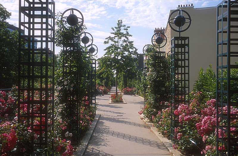
A linear park is a type of park that is significantly longer than it is wide.[a][full citation needed] These linear parks are strips of public land running along canals, rivers, streams, defensive walls, electrical lines, or highways[2] and shorelines.[3] Examples of linear parks include everything from wildlife corridors to riverways to trails, capturing the broadest sense of the word.[4] Other examples include rail trails ("rails to trails"), which are disused railroad beds converted for recreational use by removing existing structures. Commonly, these linear parks result from the public and private sectors acting on the dense urban need for open green space.[5] Linear parks stretch through urban areas, coming through as a solution for the lack of space and need for urban greenery. They also effectively connect different neighborhoods in dense urban areas as a result, and create places that are ideal for activities such as jogging or walking.[6] Linear parks may also be categorized as greenways.[7][8] In Australia, a linear park along the coast is known as a foreshoreway. When being designed, linear parks appear unique as they are planned around the public's opinion of how the space will affect them.[9]
North America
[edit]
Possibly the earliest example is the Emerald Necklace, which consists of a 1,100-acre (4.5 km2), or 445 hectare chain of parks linked by parkways (a broad, landscaped highway)[10] and waterways in Boston and Brookline, Massachusetts, U.S. The name comes from the way the planned chain appears to hang from the "neck" of the Boston peninsula.[11] This system of linear parks was designed by Frederick Law Olmsted to connect the Boston Common and Public Garden (1837) to Franklin Park (Boston), also known as the "crown jewel" of Olmstead's work in Boston.[12] The project began around 1878 with efforts to clean up and control the marshy area which later became the Back Bay and the Fens. In 1880, Olmsted proposed that the Muddy River be included in the park plan as the current dredged into a winding stream and was directed into the Charles River. Olmsted's vision of a linear park of walking paths along a gentle stream connecting numerous small ponds was complete by the turn of the century, but never completed the section to Boston Harbor. The subsequent development of the automobile industry and roads severely disrupted the original concept.[13]

In some cities, many linear parks run through residential areas. In this case, the front of the house will face the streets, while the back faces a small linear park containing a pathway, trees and grass connecting different areas together. There are examples of this in some US cities and some Canadian cities, such as Saskatoon, Canada.[14] Houses connected with linear parks are more common in suburban and rural areas where space is much less in-demand.
In the 21st century, prevalent examples of linear parks that have seen high levels of visitors are the High Line in New York City and the Bloomingdale Trail in Chicago. The High Line in New York City is a 1.4 mile (2.2 km) long rail trail and greenway, having been built on a portion of a defunct rail line as well as constructed to have greenery all throughout.[15] Like its Paris counterpart Promenade Plantee, the High Line has been transformed into a linear park that allows for activities such as sight-seeing and exercise, while being elevated. The High Line's annual budget is funded almost entirely by park visitors, though it is operated by the New York City Department of Parks and Recreation license agreement.[16] Bloomingdale Trail in Chicago is the longest linear park in the Western Hemisphere, and the second-longest linear park in the world, with a length of 2.7 miles (4.3 km), just under Paris' Promenade Plantee at 2.9 miles (4.6 km). Bloomingdale Trial was created by converting an elevated portion of the former Bloomingdale railway to this linear park, which features trees, flowers, plants, shrubbery, grass, light posts, and benches throughout. The greenway transverses through the neighborhoods of Logan Square, Humboldt Park, and West Town.
Atlanta BeltLine
[edit]
A linear park system under development in Atlanta, Georgia is the BeltLine. Part of the foundation for this project consisted of reclaiming 22 miles (35 km) of unused rail trails. Totaling approximately 33 miles (53 km), the BeltLine will include a trail and light rail line on the existing tracks instead of a road.[17] The vision of the BeltLine is to attempt to balance out resident demographics within the city, allowing for all associated to the BeltLine to benefit.[18]
Europe
[edit]In England, linear parks have also been created around waterways, especially in cities where the terrain is such that rivers and brooks have significant flood plains. Such land cannot sensibly be used for urban development and so it is set aside as a civic amenity. The settlement Milton Keynes makes extensive use of linear parks, with nine different examples that include the flood plains of the Great Ouse and of its tributaries (the Ouzel and some brooks).[19][20][21] In the UK, Milton Keynes ranked highest in a national comparison of open urban areas available to residents.[22]
In Greater London, Essex and Hertfordshire, the Lee Valley Park is a 10,000-acre (40 km2) linear park, stretching for 26 miles (42 km) long, much of it green spaces running along the flood plains of the River Lea from the River Thames to Ware, through areas such as Stratford, Clapton, Tottenham, Enfield, Walthamstow, Cheshunt, Broxbourne and Hoddesdon in an area renowned as the Lea Valley. Greater London's largest park, Lee Valley Park is more than four times the size of Richmond Park, extending beyond Greater London's borders into the neighboring counties of Hertfordshire and Essex.

A more recent example of a linear park is the Berlin Mauerpark, which was built on a part of the former Berlin Wall area and its adjacent former death strip.
Planty Park, Kraków, Poland). It encircles the Stare Miasto (Old Town), where the Medieval city walls used to stand until the early 19th century. The park has an area of 21 ha (52 acres) and a length of 4 km (2.5 mi).[23] It consists of a chain of thirty smaller gardens designed in varied styles and adorned with numerous monuments and fountains. The park forms a scenic walkway popular with Cracovians. In summer, sprinkled with ponds and refreshment stalls, it is a cool and shady retreat from the nearby bustling streets.[24]
Asia
[edit]
In Hong Kong, a prominent example of a linear park is the Avenue of Stars. Located at the waterfront surrounding East Tsim Sha Tsui, the Avenue of Stars is a 440-meter(0.27 mi.) promenade offering scenic views to the public. As a public amenity, the park provides much needed urban space to the dense city of Hong Kong. The walking road itself is dedicated to famous Hong Kong celebrities, and as such is an attractive tourist area lined with souvenir stalls at some sections.[25]
In addition to the dynamic waterfront location, the Avenue of Stars provides visitors a "front-row seat"(stand) to the Symphony of Lights, the world's largest light and sound show. It is also around this area that the Star Ferry can be observed.

In Singapore, wild growth and shrubbery that's taken over a former KTM rail line has been encouraged and maintained through public opinion. Convincing the Singaporean government of the land's value, the citizens of Singapore were able to turn a neglected KTM railway in to a linear park that now runs 10 km(6.21 mi) long and offers unique perspectives into Singaporean wildlife. Rail Corridor differs from the typical linear park in a way that promotes and integrates the biodiversity and ecosystem throughout—covering 93[26] different species—while serving as an excellent outdoor trail to get active in.[27]

In Tel Aviv, Israel, a linear park was established on the former route of the Ottoman railway between Jerusalem and Jaffa. Following the disuse of the railway the area was used as a parking lot. In 2020 the park was opened to the public.[28]
In the Philippines, the Iloilo River Esplanade is the country’s longest linear park, with a total length of 9.29 kilometres (5.77 mi). It began as part of the Iloilo River Rehabilitation Project in Iloilo City, later evolving into a popular venue for jogging and leisure, and is now lined with mangroves and other forms of riverine biodiversity.[29] A similar project in Metro Manila, the Pasig River Esplanade, is a planned 25-kilometre (16 mi) linear park, of which about 1.1 kilometres (0.68 mi) have been completed in several sections.[30]
List of linear parks
[edit]Europe
[edit]Belgium
[edit]France
[edit]
Germany
[edit]Ireland
[edit]Portugal
[edit]Romania
[edit]- Liniei Park, Bucharest
Spain
[edit]- Sagera Linear Park, Barcelona Archived 2021-01-24 at the Wayback Machine
- Parc de la Rambla de Sants, Barcelona
- Turia Gardens (Jardín del Turia), Valencia
United Kingdom
[edit]- Brampton Valley Way in Northamptonshire and Leicestershire, England
- Eastside City Park, Birmingham, England
- Hogsmill River Park, London, England
- Mile End Park, East London, England
North America
[edit]Canada
[edit]- Beltline Linear Park and West Toronto Railpath, Toronto, Ontario
- Grand Concourse (St. John's), Newfoundland: a walkway system with linear parks
- Meewasin Trail, Saskatoon, Saskatchewan
- Parc linéaire de la rivière Saint-Charles, Québec City, Québec
- Parc Linéaire Le P'tit Train du Nord, Saint-Jérôme - Mont-Laurier, Quebec.
- Strathcona Linear Park, Vancouver, British Columbia
United States
[edit]- Alewife Linear Park, Massachusetts
- Atlanta BeltLine, Atlanta, Georgia
- Bloomingdale Trail (The 606), Chicago, Illinois
- Blue Ridge Parkway, North Carolina and Virginia
- Brickell Key Baywalk, Miami, Florida
- Buffalo Bayou Park, Houston, Texas
- Burnham Greenway, Chicago, Illinois
- Charles River Esplanade, Boston, Massachusetts
- Chesapeake and Ohio Canal National Historical Park, Washington, D.C., West Virginia, and Maryland
- Delaware and Raritan Canal State Park, Central New Jersey
- Dequindre Cut, Detroit, Michigan
- East Boston Greenway, Boston, Massachusetts
- Eastern Parkway, New York City
- Elizabeth River Parkway, Union County, New Jersey
- Embarcadero, San Francisco, California
- Freeway Park, Seattle, Washington
- George Redman, East Providence-Providence, Rhode Island
- Grand Park, Los Angeles, California
- Great Highway, San Francisco, California
- High Line, New York, New York
- Hollywood Central Park, Los Angeles, California
- Hoover-Mason Trestle, Bethlehem, Pennsylvania
- Hudson River Park, New York, New York
- Illinois Prairie Path, Dupage County, Illinois
- Indianapolis Cultural Trail, Indianapolis, Indiana
- James River Park System, Richmond, Virginia[31]
- Little Sugar Creek Greenway, Charlotte, North Carolina
- Miami Riverwalk, Miami Baywalk, and future Miami River Greenway
- Midtown Greenway and trails network of Minneapolis, Minnesota
- Mosholu Parkway, The Bronx, New York City
- Ocean Parkway, New York City
- Passaic River Parkway, Union County, New Jersey
- Pastor Willie James Ford, Sr. Linear Park, Deerfield Beach, Florida[32]
- Pelham Parkway, The Bronx, New York City
- Rahway River Parkway, Union County, New Jersey
- Rose Kennedy Greenway, Boston, Massachusetts
- Riverfront Park (Arkansas River Trail), Little Rock, Arkansas
- Rotary Trail, Birmingham, Alabama
- Salesforce Park, San Francisco
- San Antonio River Walk, San Antonio, Texas
- Stowe Recreation Path, Stowe, Vermont
- The Loop, Tucson, Arizona
- The Underline, Miami-Dade County, Florida
- Vanderbilt Motor Parkway, Queens, New York City
- Walkway over the Hudson State Historic Park, Poughkeepsie and Highland, New York[33]
- Washington & Old Dominion Railroad Regional Park, Northern Virginia
Mexico
[edit]South America
[edit]Brazil
[edit]Asia
[edit]Hong Kong
[edit]Singapore
[edit]- Rail Corridor, Singapore
Iran
[edit]Israel
[edit]Japan
[edit]Philippines
[edit]- Plaza Moriones, Manila
- Camaligan River Park, Camaligan, Camarines Sur
- Iloilo River Esplanade, Iloilo City
Taiwan
[edit]South Korea
[edit]United Arab Emirates
[edit]Australia
[edit]- Stirling Linear Park, near Adelaide
- Sturt River Linear Park, near Adelaide
- The Goods Line, Sydney
- Torrens Linear Park, Adelaide
See also
[edit]Notes
[edit]- ^ There is no dictionary definition for the term in the full Oxford Dictionary of English. "Linear: Resembling a line; very narrow in proportion to its length, and of uniform breadth." (Oxford Dictionary of English) The term linear park seems to have begun to be used on a regular basis in the 1960s (Google Ngram Viewer). The earliest usage in Britain was in reference to the idea of a River Thames "linear national park", in Time on the Thames by Eric Samuel De Maré (Architectural Press, 1952) (Ngram). Google Ngram Viewer, however, indicates a few earlier examples, including from the US in 1939 (Supplementary report of the Urbanism Committee to the National Resources Committee, Volume 2. United States. National Resources Committee. Research Committee on Urbanism. Clarence Addison Dykstra. U.S. Govt. 1939). It may also have been used in 1873, but Ngram didn't provide the source(s).
References
[edit]- ^ "Paris Elevated Rail Park Featured in Movie 'Before Sunset'". Friends of the High Line. August 12, 2004. Archived from the original on October 23, 2014. Retrieved July 27, 2014.
- ^ "Parks and Recreation Programming Master Plan" (PDF). Hurst, Tx City Council. Archived from the original (PDF) on 2007-10-07. Retrieved 2009-04-06.
- ^ "Study Trail profiles". U.S. Department of Transport Federal Highway Administration. Archived from the original on 2009-05-10. Retrieved 2009-04-06.
- ^ Conference, International Linear Parks (1987). Parkways. doi:10.2307/j.ctt1xp3kv8. JSTOR j.ctt1xp3kv8. Retrieved 2021-12-06.
{{cite book}}:|website=ignored (help) - ^ Faggi, Ana (2017-01-18). "Linear Parks: The Importance of a Balanced, Cross-Disciplinary Design". The Nature of Cities. Retrieved 2021-12-07.
- ^ "6 Types of Linear Park". Simplicable. 22 September 2017. Retrieved 2021-12-07.
- ^ Truman Greenway, Savannah, Georgia, US
- ^ City of Kelowna, British Columbia, Canada
- ^ Faggi, Ana (2017-01-18). "Linear Parks: The Importance of a Balanced, Cross-Disciplinary Design". The Nature of Cities. Retrieved 2021-12-08.
- ^ "parkway."Webster's Third New International Dictionary, Unabridged. Merriam-Webster, 2002. http://unabridged.merriam-webster.com (14 Apr. 2007).
- ^ Emerald Necklace Greenway
- ^ "The Emerald Necklace Conservancy". 2007-08-30. Archived from the original on 2007-08-30. Retrieved 2021-12-07.
- ^ Emerald Necklace Greenway
- ^ "City of Saskatoon". Archived from the original on 2014-11-13. Retrieved 2014-11-16.
- ^ "Overview". The High Line. Retrieved 2021-12-07.
- ^ "History". The High Line. Retrieved 2021-12-07.
- ^ "Home". Atlanta Beltline. Retrieved 2021-12-07.
- ^ "Equity and Inclusion". Atlanta Beltline. Retrieved 2021-12-07.
- ^ Ouse Valley Park[permanent dead link] - Milton Keynes Parks Trust
- ^ Ouzel Valley Park Archived 2021-02-01 at the Wayback Machine - Milton Keynes Parks Trust
- ^ "Parks Trust Milton Keynes". Archived from the original on 2021-01-16. Retrieved 2014-11-16.
- ^ "Milton Keynes ranks top for green space". www.miltonkeynes.co.uk. 27 April 2020. Retrieved 2021-12-07.
- ^ "Planty Garden Ring". Kraków Travel. Retrieved 28 February 2022.
- ^ Andrew Beattie, From the Piast Church to the Holy Cross Church Landmark Publishing, page 40.
- ^ "About AOS | the Avenue of Stars | Harbour, Now Sparkling". the Avenue of Stars. Retrieved 2021-12-07.
- ^ "Rail Corridor". www.nparks.gov.sg. Retrieved 2021-12-08.
- ^ "The Rail Corridor : State of Buildings". stateofbuildings.sg. Retrieved 2021-12-08.
- ^ Riba, Naama (2023-05-11). "Ottoman-era Railway Becomes Tel Aviv's Newest Park. See for Yourself - Israel News - Haaretz.com". Archived from the original on 2023-05-11. Retrieved 2025-04-25.
{{cite web}}: CS1 maint: bot: original URL status unknown (link) - ^ "Iloilo River Esplanade". Urban Nature Atlas. 2024-06-01. Retrieved 2025-08-27.
- ^ Rodriguez, Mia (January 22, 2024). "The Pasig River Esplanade Is Finally Here: Here's What to Know". Spot PH. Retrieved August 27, 2025.
- ^ "James River Park System, Richmond, Virginia". Archived from the original on 2021-03-27. Retrieved 2014-03-15.
- ^ District 4 News - January 22, 2015 (Commissioner Bill Ganz)
- ^ New York State Parks, Recreation and Historic Preservation: Walkway over the Hudson State Historic Park
Linear park
View on GrokipediaDefinition and Characteristics
Core Definition
A linear park is a public open space designed in an elongated configuration, where its length substantially exceeds its width, typically following the alignment of a preexisting linear geographic or infrastructural feature such as a river, canal, roadway, shoreline, or disused railway corridor.[9] [10] This form distinguishes linear parks from traditional compact parks, emphasizing continuity and linearity to serve as corridors for movement and recreation within urban or suburban environments.[3] They are engineered to accommodate pathways for pedestrians, cyclists, and sometimes vehicles, integrating elements of transportation infrastructure with natural or landscaped greenery.[11] Linear parks often repurpose underutilized land, such as abandoned rail lines converted into trails (commonly termed "rails-to-trails"), to create accessible greenways that connect disparate urban nodes like neighborhoods, landmarks, schools, and transit hubs.[10] [12] Their narrow profile—frequently ranging from 10 to 50 meters in width—prioritizes efficient land use in densely developed areas, supporting active pursuits such as hiking, biking, and jogging alongside passive amenities like benches and interpretive signage.[13] By threading through built environments, these parks mitigate urban fragmentation, fostering ecological corridors for wildlife and stormwater management features in some designs.[14] Unlike broader park typologies, linear parks derive their functionality from their extended reach, which can span kilometers, enabling regional-scale connectivity rather than localized enclosure.[15]Physical and Functional Attributes
Linear parks exhibit a distinctive elongated form, substantially longer than they are wide, often spanning several kilometers while confined to widths typically between 10 and 100 meters.[6][16] This narrow, ribbon-like profile enables them to thread through densely built urban environments, following natural or anthropogenic linear features such as rivers, canals, roadways, or abandoned rail corridors.[9][17] Physically, these parks integrate paved or unpaved pathways for multi-modal use, interspersed with landscaped green spaces, benches, and lighting, while retaining elements of the underlying infrastructure like elevated viaducts or embankments in converted rail sites.[14][1] Functionally, linear parks prioritize connectivity, linking disparate urban nodes, existing parks, or open spaces to form extended networks for pedestrian and cyclist movement.[18][19] They support active and passive recreation, including walking, jogging, and cycling, as well as wildlife corridors and stormwater management in green variants.[20] In hybrid designs incorporating "grey" elements like waterfronts or transportation remnants, they facilitate commuting and habitat linkage alongside leisure.[20] This longitudinal orientation contrasts with compact traditional parks, emphasizing movement and accessibility over centralized gathering.[10]Historical Development
Early Origins and Precursors
Precursors to modern linear parks emerged in the mid-to-late 19th century through the development of parkways and interconnected park systems in the United States, primarily pioneered by landscape architect Frederick Law Olmsted. These linear green corridors were designed to link discrete parks, provide scenic routes for carriages and pedestrians, and integrate natural features like stream valleys into urban fabric, offering respite from city density. Unlike earlier European promenades or tree-lined avenues, which prioritized circulation, American parkways emphasized preserved natural landscapes and recreational continuity.[21][22] Olmsted's first comprehensive park and parkway system was commissioned for Buffalo, New York, in 1868, in collaboration with Calvert Vaux. This design featured wide parkways, such as the approximately 200-foot-wide connectors, linking major parks like Delaware Park and integrating linear greenways to enhance urban connectivity and public health. Similarly, in Boston, Olmsted's late 19th-century contributions to the Emerald Necklace system included linear elements like the Back Bay Fens (completed 1896), a restored marshland corridor along the Muddy River that connected Jamaica Pond to the Charles River basin, spanning over 1,100 acres in total linkage.[21][23][21] Further examples include Olmsted's 1891 plan for Louisville, Kentucky, which incorporated parkways into a broader 26-mile system developed from the 1890s through the 1930s, and early 1890s designs for Atlanta's Druid Hills, featuring a central linear park interlaced with smaller parks. These parkways, often following topographic features such as valleys and creeks, laid foundational principles for linear parks by prioritizing ecological preservation, multi-modal access, and networked green infrastructure in growing industrial cities.[24][25][26]20th-Century Emergence
The 20th century marked the practical emergence of linear parks through the adaptive reuse of disused infrastructure, particularly abandoned rail corridors, amid postwar urban decline and rising environmental awareness. In the United States, the decline of passenger rail service after World War II led to widespread abandonment of tracks, creating opportunities for conversion into public paths; by the 1960s, this spurred the rail-trail movement, which transformed rights-of-way into linear recreational spaces.[27] The Elroy-Sparta State Trail in Wisconsin, opened on October 14, 1967, became the nation's first rail trail, spanning 32 miles and featuring three tunnels originally built in the 1870s for the Chicago & North Western Railway.[27] This initiative reflected broader shifts, including federal policies like the 1965 Highway Beautification Act, which encouraged preservation of scenic corridors, though rail conversions initially relied on local advocacy.[28] Internationally, similar adaptations appeared earlier in some contexts. In Colombia, the Bogotá Parkway (Avenida Ciclovía), established in 1944, formed an early linear green corridor along urban avenues, integrating cycling paths and tree-lined routes to address traffic congestion and promote public health amid rapid city growth.[20] In Europe, green belt concepts from the early 1900s, influenced by Ebenezer Howard's garden city ideas, evolved into connected linear greenspaces, such as those proposed in the UK's 1943 County of London Plan, which envisioned ribbon developments along transport axes to counter urban sprawl.[29] These efforts prioritized multifunctionality—combining recreation, commuting, and habitat linkage—over traditional enclosed parks, aligning with mid-century critiques of automobile dominance and industrial blight.[5] By the late 20th century, institutional support solidified the trend; the U.S. Rails-to-Trails Conservancy, founded in 1986, advocated for over 1,600 miles of trails by decade's end, demonstrating scalable models for urban reconnection.[27] Empirical data from early implementations, such as increased trail usage in rural-to-urban transitions, underscored viability, though challenges like funding shortages and property disputes persisted, often resolved via railbanking laws under the 1983 National Trails System Act amendment.[28] This era's linear parks thus represented a pragmatic response to infrastructural obsolescence, prioritizing empirical reuse over expansive new land acquisition.Contemporary Evolution
The contemporary evolution of linear parks accelerated in the late 20th and early 21st centuries, driven by the adaptive reuse of abandoned rail and highway infrastructure amid urban deindustrialization and growing emphasis on sustainable urbanism.[20] Pioneered by projects like Paris's Promenade Plantée, completed in 1993 on a former elevated railway viaduct, these parks integrated linear forms with multifunctional uses, including pedestrian paths, native plantings, and public art, setting a model for transforming obsolete structures into accessible greenways.[30] This approach addressed urban fragmentation by creating continuous corridors that connect neighborhoods while repurposing underutilized land, with over 2,000 miles of rail-trails developed in the United States alone by the 2010s through organizations like the Rails-to-Trails Conservancy.[5] A pivotal example emerged with New York City's High Line, an elevated park built on a disused freight rail line last active in 1980; advocacy by Friends of the High Line began in 1999, construction started in 2006, and the first section opened to the public on June 9, 2009.[31] Spanning 1.45 miles with features like preserved rail tracks, wild gardens, and viewpoints, the High Line attracted over 8 million visitors in its first year and catalyzed $2 billion in adjacent private development by 2011, influencing a wave of similar conversions worldwide.[32] Its success demonstrated how linear parks could enhance urban biodiversity—planting over 300 species—and provide equitable access in high-density settings, though it also spurred debates on resultant property value surges.[33] In the United States, the Atlanta BeltLine exemplifies regional adaptation, originating from a 1999 master's thesis by Ryan Gravel proposing a 22-mile loop of trails, transit, and housing along abandoned rail corridors; formalized in 2005, the project saw its Eastside Trail open in October 2012, with nearly 18 miles of multi-use paths completed or under construction by 2025.[34] Globally, projects like Chicago's Bloomingdale Trail (The 606), opened in June 2015 on a 2.7-mile former rail embankment, and Seoul's Seoullo 7017 Skygarden, inaugurated in May 2017 atop a decommissioned overpass, extended this model to foster connectivity and recreation in megacities.[35] By the 2020s, linear parks had proliferated as tools for climate resilience, incorporating permeable surfaces and stormwater management, with cities investing billions to counter urban heat islands and promote active transport.[36]Design and Implementation
Types and Configurations
Linear parks are classified primarily according to the linear geographic or infrastructural features they follow, such as waterways, transportation corridors, or other elongated urban elements. These types determine design constraints, including topography, accessibility, and integration with surrounding land uses. Configurations vary in elevation, width, and connectivity, with ground-level paths common along natural features and elevated structures repurposed in dense urban settings.[14][1] Waterway-aligned linear parks follow rivers, canals, streams, or shorelines, utilizing natural corridors for pedestrian walkways, bike paths, and green infrastructure. These configurations often incorporate riparian buffers for habitat preservation and flood mitigation, with paths elevated or setback from water edges to address erosion and access issues. Examples include urban riverfront greenways that connect neighborhoods while maintaining ecological connectivity.[3][14] Transportation corridor linear parks repurpose disused rail lines, highways, or roads, converting linear rights-of-way into multi-use trails. Rail-to-trail conversions, a prominent subtype, involve grading former rail beds for flat, accessible paths suitable for recreation and commuting, often spanning long distances with minimal elevation change. Roadside variants may use medians or adjacent strips, featuring narrower designs with safety barriers.[37][30] Elevated linear parks adapt viaducts, bridges, or overhead structures, providing separated green spaces above street level to avoid ground conflicts in high-density areas. This configuration allows for layered urban design, with platforms supporting vegetation, seating, and viewpoints, as seen in repurposed freight rail spurs. Connectivity in such parks can link districts or remain localized, influencing path widths from 10 to 30 meters.[38] Other configurations include connected linear parks, which string together discrete green spaces via corridors to form extended networks, and those along historical or utility features like old walls or power line easements. These emphasize adaptive reuse, with designs balancing preservation, safety, and public access through segmented paths or widened nodes for amenities.[2][14]Key Features and Infrastructure
Linear parks incorporate multi-use pathways as central infrastructure, typically 10 to 14 feet wide to support two-way traffic for pedestrians, cyclists, and other non-motorized users, with surface materials selected based on user needs, terrain, and maintenance requirements—such as asphalt for smooth, durable access or crushed stone for softer, permeable surfaces.[39] [40] Grades are generally limited to under 5% for accessibility and usability, particularly in rail-trail conversions, while vertical clearances of 8 to 10 feet accommodate various users under overpasses or tunnels.[39] [41] Safety features predominate in designs adjacent to active rail lines, including setbacks of 7 to 200 feet from tracks—averaging 32 feet—combined with physical barriers like fencing, berms, ditches, or dense vegetation to prevent trespassing and ensure visibility.[41] Crossings between trails and rail lines prioritize grade-separated structures such as overpasses or underpasses compliant with Americans with Disabilities Act (ADA) standards, featuring approach grades of 5% or less; at-grade crossings, when unavoidable, incorporate Manual on Uniform Traffic Control Devices (MUTCD)-compliant signage, signals, and pavement markings.[41] Lighting is integrated at crossings, underpasses, and high-traffic areas to enhance visibility, often motion-activated to minimize energy use and light pollution toward rail operations.[41] Landscaping elements form green corridors with native trees, shrubs, rain gardens, and vertical greenery to support biodiversity and stormwater management, while drainage systems employ grade reversals every 100 feet and outsloping to direct water away from paths, preventing erosion in linear alignments.[40] [16] Elevated linear parks, such as those repurposed from viaducts, require structural reinforcements, retaining walls, and integrated access via stairs, elevators, or ramps to maintain connectivity without disrupting urban flow.[42] Frequent entry points via sidewalks and local streets ensure seamless integration with surrounding neighborhoods, supplemented by amenities like benches, interpretive signage, and secure bicycle parking at transit connections.[16] [39] Vegetation management protocols emphasize pruning for sightlines and compatibility with adjacent land uses, such as railroad herbicide applications, to sustain long-term functionality.[41]Planning and Construction Processes
The planning of linear parks typically begins with identification of suitable linear corridors, such as abandoned rail lines, utility easements, or riverbanks, followed by comprehensive feasibility studies assessing land ownership, environmental conditions, potential contamination from prior industrial use, and stakeholder interests.[43] These studies evaluate engineering viability, projected costs—often ranging from $1.1 million to $1.3 million per mile for rail-trail conversions due to structural elements like bridges—and economic impacts, including tourism potential and property value effects.[44] For rail corridors, federal law under the National Trails System Act enables "railbanking," preserving rights-of-way for interim trail use without full abandonment, preempting state reversion laws that could fragment ownership among adjacent parcels.[45] [46] Funding acquisition forms a critical phase, relying on a mix of federal grants (e.g., TIGER discretionary funds emphasizing safety, state of good repair, and economic competitiveness), state recreation trusts, municipal bonds, and public-private partnerships, as seen in projects like the Summit Park Line where grant criteria demand quantifiable outcomes in mobility and livability.[47] Community engagement, including public hearings and coordination with utilities or railroads for "rails with trails" coexistence, mitigates opposition from property owners or safety concerns, though protracted negotiations can delay timelines by years.[48] Design phases involve multidisciplinary teams of landscape architects, civil engineers, and ecologists to integrate accessibility features under the Americans with Disabilities Act, stormwater management, and native planting schemes tailored to the corridor's constraints.[48] Construction processes prioritize site remediation, particularly for rail sites with hazardous materials like creosote-treated ties, requiring environmental assessments and cleanup compliant with EPA standards before grading or paving multi-use paths.[43] For elevated structures, as in New York City's High Line, engineers address load-bearing reinforcements, corrosion-resistant materials, and custom drainage systems to prevent hydrostatic pressure buildup, rethinking conventional park elements like soil depths limited to 18-24 inches over steel decks.[49] [50] Phased implementation—often segment by segment to manage costs and disruptions—includes installing safety barriers, lighting, and access ramps, with construction bids emphasizing modular prefabrication to minimize urban interference.[51] Post-construction monitoring ensures structural integrity and adaptive management for vegetation, as linear parks' elongated forms amplify maintenance logistics compared to compact green spaces.[52]Purported Benefits
Environmental Claims
Linear parks are often promoted for their role in enhancing urban biodiversity by serving as green corridors that connect fragmented habitats, facilitating wildlife movement and supporting pollinators in densely built environments.[52] For example, the High Line in New York City, an elevated linear park on a former rail line, has been credited with increasing native plant species diversity by over 200%, from 245 to more than 700 species through intentional planting and natural succession.[53] Proponents argue this linear configuration amplifies ecological connectivity compared to isolated patches, potentially boosting insect and bird populations in urban settings.[54] Another key claim involves carbon sequestration and air quality improvement via vegetation cover and reduced impervious surfaces. The High Line's 750 newly planted trees are estimated to sequester over 1.3 tons of atmospheric carbon annually, while the park's design incorporates drought-tolerant plants to minimize maintenance emissions.[53] [55] Broader assertions suggest linear parks contribute to urban cooling by mitigating heat islands through shade and evapotranspiration, with studies on similar green infrastructure indicating potential temperature reductions of 1-4°C in adjacent areas during peak heat.[56] Stormwater management is frequently cited as a benefit, with linear parks purportedly reducing runoff through permeable pavements, bioswales, and vegetated buffers that infiltrate rainwater and filter pollutants.[57] In designs like the High Line, these features are said to handle significant volumes—up to thousands of gallons per storm event—easing pressure on municipal systems and promoting groundwater recharge.[53] Advocates, including landscape architecture organizations, emphasize that repurposing linear infrastructure like rail corridors inherently supports these functions by integrating ecology into underutilized urban linear assets.[58] However, such claims often derive from modeling or site-specific pilots rather than long-term, comparative empirical data across diverse linear park implementations.[59]Economic Effects
Linear parks have been associated with increases in nearby property values, with empirical studies indicating premiums ranging from 3% to 5% for proximity to greenways and linear open spaces.[60] In specific cases, such as New York City's High Line, homes within close proximity experienced a 35.3% rise in housing values attributable to the park's development, as identified through hedonic pricing models controlling for other urban factors.[8] These effects reflect capitalization of public goods into real estate, where improved accessibility and amenities enhance perceived desirability, though the magnitude diminishes with distance from the park.[61] Development around linear parks often generates substantial private investment. For Atlanta's BeltLine, $800 million in public funding has spurred nearly $10 billion in private development as of 2025, including residential, commercial, and mixed-use projects along the corridor.[62] Similarly, the High Line has contributed to over $1 billion in increased tax revenue and the creation of approximately 12,000 jobs in surrounding areas through redevelopment of industrial sites into offices, retail, and housing.[63] Local business vitality can improve, particularly in economically distressed neighborhoods. A study of Seoul's Gyeongui Line Forest Park found positive economic spillovers to nearby businesses via increased visitation, with sales growth in retail and services outweighing any displacement effects in lower-income zones.[64] However, these benefits vary by context; in already affluent areas, gains may primarily accrue to existing property owners rather than broad economic multipliers.[65] Overall, while linear parks demonstrate causal links to localized economic uplift through empirical hedonic and impact analyses, long-term returns depend on complementary urban policies to sustain infrastructure and mitigate uneven distribution.[64]Social and Health Outcomes
Linear parks, often developed as greenways or rail-trails, have been associated with modest increases in physical activity levels among nearby residents. A meta-analysis of nine studies involving over 6,000 participants found that greenway interventions yielded small but statistically significant improvements in active travel (standardized mean difference [SMD] = 0.10), moderate-to-vigorous physical activity (SMD = 0.11), and total physical activity (SMD = 0.14), primarily through self-reported measures in natural experiment designs.[66] These effects were more pronounced with longer exposure durations (≥12 months) and proximity within 1-2 km, though reliance on self-reports introduces recall bias risks, and no randomized controlled trials provide stronger causal evidence.[66] Similarly, a systematic review of new urban trail infrastructure indicated elevated physical activity in proximal areas compared to controls, supporting potential health gains like reduced cardiovascular risk, but effect sizes remained limited and context-dependent on high-income settings.[67] Mental health outcomes linked to linear parks include stress reduction and enhanced well-being, facilitated by natural elements and restorative environments. Surveys of urban park users, including greenway trails, report decreased mental fatigue and improved emotional responses through green exercise, with regression models showing natural features (e.g., greenery) positively influencing restoration (β = 0.315, p < 0.001).[68] Economic analyses of trail interventions highlight quality-of-life improvements alongside physical gains, though these derive from observational data prone to confounding by user self-selection—active individuals may preferentially use such spaces.[69] Barriers like seasonal inaccessibility (e.g., snow on trails) can limit benefits for vulnerable groups, such as older adults, underscoring uneven access.[70] Social outcomes encompass increased interactions and community cohesion, as linear parks provide venues for casual encounters and group activities. Empirical reviews link urban green spaces, including trails, to stronger perceived social ties, with nature exposure correlating to higher cohesion scores in community surveys.[71] Greenways specifically facilitate social engagement among users, enhancing safety perceptions and belonging through shared use, though evidence remains correlational and may overstate causality due to endogeneity in observational studies.[70] Overall, while purported benefits align with broader urban greenspace research, rigorous causal demonstrations are scarce, with many claims resting on advocacy-influenced or methodologically limited sources rather than replicated experiments.[66]Criticisms and Empirical Realities
Gentrification and Displacement
Linear parks frequently contribute to gentrification by boosting adjacent property values and rents, which can displace lower-income residents through economic pressures rather than direct eviction. Empirical studies document this "green gentrification" pattern, where investments in elevated green infrastructure attract affluent newcomers, altering neighborhood demographics without adequate safeguards for existing vulnerable populations.[72][8] In New York City's High Line, completed in stages from 2009 to 2014, properties nearest the park saw a 35.3% hedonic premium in housing values, with resale prices in Section 1 rising 50.6% and Section 2 by 48.2% as of May 2016 compared to pre-development baselines. These gains primarily accrued to homeowners with direct access, while renters in surrounding areas faced intensified affordability challenges, correlating with broader displacement risks in gentrifying zones.[8][73][74] Atlanta's BeltLine, launched in 2005, exemplifies similar dynamics, with 22% of lower-income neighborhoods at risk of gentrification and 7% experiencing displacement of low-income households without incoming higher-income replacement as of 2017. Housing costs surged rapidly in nearly 50% of city neighborhoods between 2000 and 2017, contributing to a citywide loss of over 40% of majority-Black census tracts from 1980 to 2020, particularly along the western and eastern corridors where lower-income, majority-Black/Latinx areas saw exclusionary trends.[75][76] Internationally, São Paulo's Tietê River Valley linear park project has proposed resettling around 40,000 low-income residents from river-edge favelas to facilitate greenspace development, highlighting how such initiatives can embed displacement in planning phases under the guise of ecological restoration. While anti-displacement efforts like affordable housing mandates exist, their scale often lags behind value uplifts, underscoring causal links from park proximity to socioeconomic exclusion in peer-reviewed analyses.[77][52]Maintenance and Cost Challenges
Linear parks, due to their elongated and often elevated or constrained designs, incur elevated maintenance demands compared to traditional parks, including regular vegetation management to prevent overgrowth, structural inspections for erosion or instability, and enhanced security measures across extended perimeters vulnerable to vandalism and unauthorized access. These factors contribute to higher operational costs, with annual expenses for highly landscaped urban linear trails reaching up to $102,000 per mile, encompassing daily trash removal, irrigation, and pathway repairs.[78] Funding models frequently rely on public budgets or business improvement districts (BIDs), but inflation in labor and materials—often outpacing budgetary increases of 3-5% annually—exacerbates shortfalls, leading to deferred maintenance like uneven surfaces or drainage failures.[79] A prominent example is New York City's High Line, where annual maintenance for Sections 1 and 2 was estimated at $3.5-4.5 million as of 2009, translating to $522,388-$671,641 per acre and straining local business assessments through the supporting BID.[80][81] This reflects broader patterns in converted rail corridors, where specialized infrastructure like waterproofing elevated structures and controlling invasive species adds recurring expenses not fully offset by visitor fees or grants, prompting reliance on philanthropy that may fluctuate with economic conditions.[53] In Atlanta's BeltLine, a 22-mile linear park and trail system, fiscal pressures have manifested in a $242 million budget approval for 2026 amid rising overall project costs, with maintenance challenges compounded by rapid development outpacing infrastructure upkeep and hidden deferred expenses in municipal accounting.[82][83] Such cases underscore causal risks: initial construction hype often underestimates lifecycle costs, where linear geography amplifies logistics for routine tasks like debris clearance after storms, potentially leading to safety hazards or reduced usability if public funding proves insufficient. Empirical data from trail management toolkits indicate suburban linear segments with amenities like restrooms demand at least $7,800 per mile yearly, highlighting the need for realistic fiscal planning to avoid reliance on unsustainable subsidies.[78]Questionable Environmental Efficacy
Despite claims of enhancing urban biodiversity, linear parks often exhibit limited ecological efficacy due to their narrow configurations, which create pervasive edge effects that diminish habitat quality for species requiring interior forest conditions. Forest edge creation globally impacts over half of forested areas by altering microclimates, increasing predation, and reducing vertebrate diversity, with linear urban parks amplifying these issues through constant exposure to urban disturbances like noise, light pollution, and invasive species. Empirical assessments of linear parks in Los Angeles revealed an average of only 2.5 indicator wildlife species within park boundaries, with just 40% of flora being locally native, underscoring reliance on managed, non-native plantings rather than self-sustaining ecosystems. Over-maintenance practices, such as excessive manicuring that removes leaf litter and understory, further erode habitat value, preventing the development of complex soil biota essential for long-term biodiversity support.[84][85] Urban linear parks can inadvertently function as ecological traps or population sinks, attracting wildlife to suboptimal habitats where fitness is lower than in available alternatives due to heightened mortality from domestic predators, pollution, and human activity. While some studies document increased planted species diversity—such as the High Line's shift from 245 to over 500 species and cultivars—this primarily reflects horticultural intervention rather than enhanced native or wild biodiversity, with shallow, artificial soils in elevated structures constraining root systems and microbial communities critical for ecosystem resilience. Broader reviews indicate that not all urban greenspaces equally support conservation; linear designs, constrained by infrastructure remnants, often fail to provide the connectivity or refugia needed to counter urbanization's fragmenting effects on metapopulations.[86][53][87] Carbon sequestration and other regulatory services in linear parks remain modest relative to construction and upkeep costs, with elevated examples like the High Line capturing only about 1.3 tons annually through 750 trees across 1.45 miles, a fraction compared to equivalent investments in rural reforestation or natural habitat preservation. Cooling benefits exist locally—averaging 3.3°C reduction extending 344 meters in Los Angeles riverine linear parks—but are variable and dependent on adjacent land covers, potentially offset by impervious paths and visitor-induced compaction that limit groundwater infiltration and long-term soil health. These limitations suggest that while linear parks contribute incrementally to urban microclimates, their net environmental impact prioritizes aesthetic and recreational outcomes over scalable ecological restoration, with efficacy further questioned by the opportunity costs of diverting resources from protecting intact ecosystems elsewhere.[53][85]Overstated Social Impacts
Proponents of linear parks frequently claim they bolster social cohesion by facilitating spontaneous interactions, reducing isolation, and strengthening community ties in dense urban environments. However, a systematic review of 41 studies on urban parks concluded that none provided conclusive evidence demonstrating enhanced social cohesion, with most relying on correlational data rather than causal mechanisms.[56] Empirical assessments reveal that observed social interactions in parks often occur among individuals with pre-existing networks, rather than generating new bonds across diverse groups, limiting claims of broad integrative effects.[88] For instance, older adults with established social connections visit urban green spaces more frequently, suggesting parks amplify existing ties but do not independently drive cohesion for isolated populations.[89] Access disparities further undermine purported inclusive impacts, as lower-income residents and communities of color encounter barriers such as neighborhood stigma and unequal amenity distribution, resulting in parks that serve affluent or transient users disproportionately.[90][91] In linear park projects like those in Mexico City, designs intended as shared urban commons have evolved into exclusionary spaces dominated by higher-status visitors, widening social fractures instead of bridging them.[92] High-profile examples, such as New York's High Line, illustrate how tourism-driven visitation overshadows local community engagement, with social media analyses showing content focused on leisure aesthetics rather than sustained interpersonal connections among residents.[93] Overall, while linear parks may host incidental interactions, the absence of robust, causal evidence for transformative social outcomes indicates that such benefits are routinely exaggerated relative to verifiable impacts.[94]Notable Examples
North America
One of the earliest linear park systems in North America is Boston's Emerald Necklace, designed by Frederick Law Olmsted in the 1890s as a 1,100-acre chain of parks connected by linear parkways totaling approximately 10 miles.[1] This network, including the Arnold Arboretum and Franklin Park, integrated natural landscapes with urban infrastructure to provide recreational corridors amid growing city density.[1] The High Line in New York City exemplifies modern adaptive reuse of disused rail infrastructure into an elevated linear park. Opened in June 2009, the 1.45-mile (2.33 km) greenway on a former freight rail spur features native plantings of over 500 species, pathways, and public art installations, drawing 8 million visitors in its first year alone.[31] Construction began in 2006 after advocacy efforts preserved the structure from demolition, transforming it into a continuous public space maintained by the nonprofit Friends of the High Line.[31] Economic analyses indicate it has spurred $2.2 billion in private development and generated $1.4 billion in city tax revenue from 2007 to 2027.[53] In Atlanta, the BeltLine project redevelops a 22-mile loop of abandoned rail corridors into a multi-use trail system with parks, affordable housing, and eventual streetcar transit. Conceived in 2005 from a Georgia Tech student's thesis, it has seen 17 miles of trails completed by 2025, connecting 45 neighborhoods and attracting $10 billion in adjacent investments.[95] Ongoing phases, including the 4-mile Southside Trail, involve $200 million in funding for segments expected to open by late 2025, emphasizing stormwater management and habitat restoration alongside recreation.[96] [97] Other notable examples include Chicago's 606, a 2.7-mile elevated trail on former rail lines opened in 2015, which boosted property values by 53% in surrounding areas within five years.[35] In Canada, Toronto's West Toronto Railpath, a 5.6 km linear park along active and disused tracks established in phases since 2008, provides urban connectivity with wooded buffers and community gardens.[98] These projects highlight a trend of repurposing linear corridors for pedestrian and cycling access, though maintenance costs average $20 per linear foot annually across similar U.S. installations.[1]Europe
The Promenade Plantée, also known as the Coulée Verte René-Dumont, in Paris, France, represents Europe's inaugural elevated linear park, constructed atop the disused Vincennes railway viaduct and embankment.[99] The original railway line, established in 1859 to connect Bastille station to Vincennes, operated until the 1960s when passenger services ceased, leaving the infrastructure abandoned.[100] [101] Converted and opened to the public in 1993, the 4.7-kilometer pathway features a mix of elevated sections up to 10 meters high and ground-level trails, planted with diverse flora including plane trees, maples, and ivy-covered walls, accommodating pedestrians and offering panoramic city views.[102] [103] In London, United Kingdom, the Parkland Walk exemplifies a ground-level linear park transformed from a Victorian-era railway corridor. Spanning approximately 4.5 kilometers from Finsbury Park to Highgate, it traces sections of the former Edgware, Highgate and London Railway, which began operations in the 1860s and was fully closed by the 1970s due to declining usage.[104] [105] Officially opened as a public path in 1984 following resurfacing and access improvements, it was designated a local nature reserve in 1990, fostering habitats for urban wildlife such as foxes, bats, and over 300 plant species amid tunnels, bridges, and graffiti-adorned remnants of the rail infrastructure.[106] [107] Italy's Precollinear Park in Turin demonstrates adaptive reuse of urban transport remnants on a smaller scale. Developed from a 700-meter abandoned tramway line overlooking the Po River, the project began as a temporary initiative during the COVID-19 pandemic in 2020 and evolved into a permanent linear green space by 2021, featuring playable surfaces, community gardens, and event areas integrated into the precollinare neighborhood.[108] [109] This conversion addressed underutilized infrastructure while enhancing local recreation, with widened paths and modular installations promoting biodiversity and social interaction.[110]Asia
Seoullo 7017 in Seoul, South Korea, represents an innovative repurposing of urban infrastructure into an elevated linear park, converting a disused 1970s overpass spanning 1,024 meters into a pedestrian greenway. Opened on May 20, 2017, the park incorporates 24,000 plants from 228 Korean species, arranged in themed zones to function as a botanical showcase, alongside cultural pavilions and event spaces that promote biodiversity and public interaction in the city's dense core.[111][112] The Gyeongui Line Forest Park, also in Seoul, extends 6.3 kilometers from Gajwa Station in Mapo-gu to Wonhyo-ro in Yongsan-gu, transforming segments of the abandoned Gyeongui railway—originally built in 1905—into a ground-level linear pathway. Developed in three phases concluding in 2016, it includes restored rail tracks, wetlands, fitness zones, and shaded trails for walking and cycling, drawing millions of users annually by integrating remnant industrial heritage with native vegetation to mitigate urban heat and fragmentation.[113][114][115] Singapore's Rail Corridor, a 24-kilometer linear greenway tracing the former Keretapi Tanah Melayu (KTM) railway alignment from Kranji in the north to Tanjong Pagar in the south, exemplifies island-wide connectivity through adaptive reuse of a century-old transport route decommissioned in 2011. Progressive openings since 2021 have introduced elevated boardwalks, heritage trusses, and ecological enhancements like the Bukit Timah Nature Reserve linkage, fostering habitat corridors for species such as colugos while accommodating 1.5 million projected annual visitors via improved access points and minimal intervention to preserve ecological integrity.[116][117] In Shanghai's Putuo District, the Caoyang Centennial Park redevelops a 1-kilometer segment of disused rail infrastructure—10 to 15 meters wide—into a multilevel, vine-like structure blending elevated walkways, basketball courts, galleries, and community gardens. Completed around 2022 by Atelier Liu Yuyang Architects, the design emphasizes vertical layering to maximize limited urban space, incorporating permeable surfaces and native plantings to enhance stormwater management and resident engagement in a high-density workers' village setting.[118][119]Other Regions
The River Torrens Linear Park in Adelaide, South Australia, extends approximately 30 kilometers along the River Torrens valley, connecting the Adelaide Hills to the Gulf St. Vincent, and was completed in 1997 as Australia's inaugural and most extensive linear park.[120] This system integrates revegetated biodiversity corridors, pedestrian and cycling paths, and recreational facilities, serving as a model for combining flood mitigation with urban green space.[121] It supports local ecosystems by restoring native vegetation along an 8.4-kilometer section managed by the City of Charles Sturt, while providing continuous access for over 144 documented trails with varying elevation gains up to 570 feet. In South America, linear parks have been implemented to address urban flooding, heat islands, and connectivity challenges. In Campinas, Brazil, a network of linear parks follows stream corridors, incorporating permeable surfaces and native planting to reduce flood risks from heavy rainfall and mitigate urban heat, with developments accelerating after 2022 initiatives.[124] The Córrego Grande Linear Park in Florianópolis, Brazil, established in a preservation area with a 30-meter riparian setback, features low-impact structures like boardwalks and viewing platforms along a stream, completed by 2022 to enhance habitat connectivity without disrupting natural hydrology.[125] In Chile, the Linear Park in Carahue integrates hierarchical path systems along the terrain's natural geometry, providing urban-ring circulation and recreational access while preserving ecological flows.[126] African examples remain developmental, with the Linear Park Project in Lagos, Nigeria, proposed to blend non-motorized transport routes with green corridors for improved urban mobility and air quality, though implementation details post-initiation in the 2010s are limited by funding and infrastructure constraints.[127] These initiatives in Oceania and the Americas demonstrate linear parks' adaptability to regional hydrology and urban pressures, often prioritizing resilience over aesthetic replication of rail-trail models.Broader Impacts and Future Prospects
Urban Planning Influence
The concept of linear parks traces its roots to Frederick Law Olmsted's design for Boston's Emerald Necklace, a system of interconnected parks and parkways proposed between 1879 and 1894, which integrated linear green corridors into the urban fabric to address public health concerns amid rapid industrialization and to manage stormwater and waste from expanding neighborhoods.[128][129] This approach influenced early urban planning by demonstrating how linear landscapes could organize metropolitan growth, provide recreational pathways, and mitigate environmental degradation in dense cities, setting a precedent for park systems that prioritize connectivity over isolated green spaces.[22][130] In the 20th century, Olmsted's greenway ideas evolved into formalized planning strategies, with the term "greenway" emerging in the 1950s to describe linear corridors linking natural and urban areas for conservation, recreation, and transportation, as seen in post-World War II landscape architecture efforts.[130] These developments paralleled innovations in American urban design, encouraging planners to incorporate multifunctional linear features—such as waterfronts and rail corridors—into zoning and land-use policies to enhance ecological services and urban resilience.[22] By the late 20th century, greenway planning had become a staple in landscape architecture, influencing federal initiatives like the U.S. National Trails System Act of 1968, which facilitated conversions of abandoned rail lines into linear parks.[131] Contemporary linear parks, exemplified by New York City's High Line—opened in 2009 on a disused elevated rail structure—have reshaped urban planning paradigms by advocating adaptive reuse of obsolete infrastructure, fostering public-private partnerships, and integrating native vegetation with pedestrian pathways to create hybrid public spaces.[132][133] The High Line's success prompted over 100 similar projects worldwide, influencing city planners to prioritize elevated or linear green infrastructure for connectivity, biodiversity, and economic revitalization, though empirical studies emphasize the need for context-specific adaptations to avoid uniform replication.[134][135] In New Urbanism, linear greenways bordering neighborhoods have been integrated into master plans to promote walkability and mixed-use development, as evidenced in communities designed since the 1990s that use such features to delineate and link urban nodes.[136] Linear parks have also advanced sustainable urban planning by embedding principles of multifunctionality, where corridors serve ecological restoration, flood control, and active transportation, influencing policies in cities like Seoul, where the Cheonggyecheon restoration—a 5.8 km urban stream converted into a linear park in 2005—demonstrated measurable reductions in urban heat islands and improvements in air quality.[137] However, planning influences remain tempered by site-specific challenges, with research indicating that linear designs must balance recreation with maintenance to sustain long-term urban integration.[64] Overall, these parks have shifted urban design toward resilient, networked green systems, though their adoption often requires rigorous cost-benefit analyses to verify broader planning efficacy.[138]Lessons from Failures and Successes
The development of linear parks has demonstrated that grassroots advocacy and strategic visual documentation can mobilize public and political support, as evidenced by the High Line in New York City, where photographs of the site's natural vegetation helped preserve the abandoned rail structure in 2002 and facilitated its transformation into a park opened in 2009.[139] Public-private partnerships, combining nonprofit fundraising with municipal resources, have proven essential for funding initial construction and ongoing operations, enabling the High Line to attract approximately 7 million visitors annually by 2024 while boosting adjacent property values through increased economic activity.[140] [53] Ecological design principles, such as planting native species in thin soil layers despite urban constraints, have yielded measurable biodiversity gains, with the High Line increasing plant species from 245 to over 500 cultivars and supporting pollinators like 33 native bee species.[140] [53] Adaptive reuse of disused infrastructure also enhances connectivity, as seen in waterfront linear parks that integrate trails with existing urban paths, promoting resident satisfaction and interaction with natural features when accessibility and safety are prioritized.[141] However, success hinges on anticipating environmental stressors, such as soil limitations and microclimates, requiring vigilant maintenance to prevent plant die-off and sustain visitor appeal over decades.[140] Challenges from uneven implementation reveal that linear parks can exacerbate gentrification, with empirical studies linking them to higher rates of resident displacement in low-income areas, particularly those near downtowns, due to rising property values that outpace affordability protections.[142] [8] In cases like post-industrial neighborhoods, new linear green spaces have correlated with demographic shifts favoring higher-income influxes, underscoring the need for concurrent anti-displacement measures, such as community land trusts or inclusionary zoning, to equitably distribute benefits.[143] Funding shortfalls and governance gaps often lead to underutilization or deferred maintenance, as observed in projects where inadequate connections to transit or local amenities result in low usage despite initial investments.[144] Overall, while linear parks empirically elevate nearby property values by up to 20% for abutting parcels through the "proximate principle," causal attribution requires caution, as selection bias in site choices may inflate apparent impacts without rigorous controls for pre-existing trends.[145] Lessons emphasize integrating socioeconomic safeguards from inception, prioritizing scalable maintenance models, and evaluating outcomes via longitudinal data to avoid overreliance on short-term metrics like visitor counts, which may mask social costs.[72]Emerging Trends and Innovations
Linear parks are increasingly engineered for climate resilience, featuring adaptive designs such as elevated boardwalks, permeable surfaces, and native plantings to mitigate flooding, erosion, and heat stress. The Rails-to-Trails Conservancy's April 2025 guidebook, Trails as Resilient Infrastructure, advocates for these elements to integrate trails into broader transportation networks, reducing repair costs by anticipating hydrological changes and extreme weather.[146] Urban cooling represents a key innovation, with linear parks providing measurable reductions in ambient temperatures through shading and evapotranspiration. A June 2025 study by Climate Central, conducted for the High Line in New York City, quantified the park's capacity to lower urban heat, highlighting its role in countering heat islands without expansive land requirements.[147] Material reuse in construction is advancing sustainability, as demonstrated by the Winton Linear Park in Hayward, California, completed in 2024, which repurposed 250 tons of deconstructed concrete into pavers, refurbished vintage benches, and utilized onsite soils for landforms, yielding a carbon footprint reduction via local sourcing and a development cost of $2 million for 7 acres.[148] Integration of Internet of Things (IoT) sensors is an emerging trend, enabling data collection on usage patterns, air quality, and microclimates to inform adaptive management. These systems support predictive maintenance and biodiversity monitoring, with applications in extended green spaces facilitating real-time adjustments to visitor flows and ecological health.[149] As green corridors, linear parks are innovating to enhance urban biodiversity by linking habitats with stratified vegetation layers and wildlife-friendly infrastructure. Recent initiatives prioritize ecological connectivity, such as permeable designs that allow species movement across urban fragments, contributing to resilient ecosystems amid habitat loss.[150]References
- https://www.charlessturt.sa.gov.au/environment/[biodiversity](/page/Biodiversity)/river-torrens-linear_park
- https://www.alltrails.com/parks/[australia](/page/Australia)/south-australia/river-torrens-linear-park
