
Community hub
Recent from talks
Contribute something
Nothing was collected or created yet.
| Mile | |
|---|---|
 A milestone in the City of Westminster showing the distance from Kensington Road to Hounslow and Hyde Park Corner in miles | |
| General information | |
| Unit system | British imperial/US customary |
| Unit of | length |
| Symbol | mi. or mi, (rarely) m |
| Conversions | |
| 1 mi. or mi in ... | ... is equal to ... |
| SI units | 1609.344 m |
| imperial/US units | |
| US survey mile | 0.999998 survey mile |
| nautical units | ≈ 0.86898 nmi[n 1] |
The mile, sometimes the international mile or statute mile to distinguish it from other miles, is a British imperial unit and United States customary unit of length; both are based on the older English unit of length equal to 5,280 English feet, or 1,760 yards. The statute mile was standardised between the Commonwealth of Nations and the United States by an international agreement in 1959, when the yard was formally redefined with respect to SI units as 0.9144 metres, making the mile exactly 1609.344 metres (1.609344 kilometres). For everyday use, five miles equates roughly to eight kilometres.
With qualifiers, mile is also used to describe or translate a wide range of units derived from or roughly equivalent to the Roman mile (roughly 1.48 km), such as the nautical mile (now 1.852 km exactly), the Italian mile (roughly 1.852 km), and the Chinese mile (now 500 m exactly). The Romans divided their mile into 5,000 pedes (lit. 'feet'), but the greater importance of furlongs in the Elizabethan-era England meant that the statute mile was made equivalent to 8 furlongs or 5,280 feet in 1593. This form of the mile then spread across the British Empire, some successor states of which continue to employ the mile. The US Geological Survey now employs the metre for official purposes, but legacy data from its 1927 geodetic datum has meant that a separate US survey mile (6336/3937 km) continues to see some use, although it was officially phased out in 2022. While most countries replaced the mile with the kilometre when switching to the International System of Units (SI), the international mile continues to be used in some countries, such as the United Kingdom, the United States, and a number of countries with fewer than one million inhabitants, most of which are UK or US territories or have close historical ties with the UK or US.
Name
[edit]The modern English word mile derives from Middle English myle and Old English mīl, which was cognate with all other Germanic terms for miles. These derived from the nominal ellipsis form of mīlle passus 'mile' or mīlia passuum 'miles', the Roman mile of one thousand paces.[1]
The present international mile is usually what is understood by the unqualified term mile. When this distance needs to be distinguished from the nautical mile, the international mile may also be described as a land mile or statute mile.[2] In British English, statute mile may refer to the present international mile or to any other form of English mile since the 1593 Act of Parliament, which set it as a distance of 1,760 yards. Under American law, however, statute mile refers to the US survey mile.[3] Foreign and historical units translated into English as miles usually employ a qualifier to describe the kind of mile being used but this may be omitted if it is obvious from the context, such as a discussion of the 2nd-century Antonine Itinerary describing its distances in terms of miles rather than Roman miles.
Abbreviation
[edit]The mile has been variously abbreviated in English—with and without a trailing period—as "mi", "M", "ml", and "m".[4] The American National Institute of Standards and Technology now uses and recommends "mi" to avoid confusion with the SI metre (m) and millilitre (ml).[5] However, derived units such as miles per hour or miles per gallon continue to be abbreviated as "mph" and "mpg" rather than "mi/h" and "mi/gal". In the United Kingdom, road signs use "m" as the abbreviation for mile though height and width restrictions also use "m" as the symbol for the metre, which may be displayed alongside feet and inches.[6] The BBC style holds that "there is no acceptable abbreviation for 'miles'" and so it should be spelled out when used in describing areas.[7]
Historical
[edit]
Roman
[edit]The Roman mile (mille passus, lit. "thousand paces"; abbr. m.p.; also milia passuum[n 2] and mille) consisted of a thousand paces as measured by every other step—as in the total distance of the left foot hitting the ground 1,000 times.[9] The distance was indirectly standardised by Agrippa's establishment of a standard Roman foot (Agrippa's own) in 29 BC,[10] and the definition of a pace as 5 (Roman) feet.[citation needed] An Imperial Roman mile thus denoted 5,000 Roman feet. Surveyors and specialised equipment such as the decempeda and dioptra then spread its use.[11]
In modern times, Agrippa's Imperial Roman mile was empirically estimated to have been about 1,618 yards (1,479 m; 4,854 ft; 0.919 mi) in length, slightly less than the 1,760 yards (1,609 m; 5,280 ft) of the modern international mile.[12]
In Hellenic areas of the Empire, the Roman mile (Ancient Greek: μίλιον, mílion) was used beside the native Greek units as equivalent to 8 stadia of 600 Greek feet. The mílion continued to be used as a Byzantine unit and was also used as the name of the zero mile marker for the Byzantine Empire, the Milion, located at the head of the Mese near Hagia Sophia.
The Roman mile spread throughout Europe, with its local variations giving rise to the different units.[13] Also arising from the Roman mile is the milestone. All roads radiated out from the Roman Forum throughout the Empire – 50,000 (Roman) miles of stone-paved roads. At every mile was placed a shaped stone. Originally, these were obelisks made from granite, marble, or whatever local stone was available. On these was carved a Roman numeral, indicating the number of miles from the centre of Rome – the Forum. Hence, one can know how far one is from Rome.[14]
Ptolemaic mile
[edit]In the 2nd-century, Greco-Roman polymath, Claudius Ptolemy, of Alexandria (Egypt), in his Almagest and Geography, defined a mile as a geographic arcminute of longitude, of the earth's circumference, equivalent to 1:60 of a degree of longitude, or 1:21,600 of the circumference.[15] While his estimate of the circumference of the earth, and therefore the derived length of a stade, and a mile, from third party observations, principally offered in non-normalised stadion (600 Greek feet), Egyptian schoinos, and Persian parasang were erroneous.[clarification needed] Ptolomy's assumptions of a customary stade to be 1/8 of a Roman mile, 1/30 of a schoinos or parasang, 1/500 of an arc-minute, or ~185 metres,[16][17] his Geographical mile, is the basis of the current nautical mile, and was adopted by medieval Arab and European cartographers.[18][19]
Arabic
[edit]The Arabic mile (الميل, al-mīl), of 4,000 cubits, was not the common Arabic unit of length; instead, Arabs and Persians traditionally used the longer parasang or "Arabic league". Although the precise length of the Arabic mile remains disputed, due to the variability in cubit length, it was somewhere between 1.8 and 2.0 km. The Arabic mile being approximate to a 1.852 km nautical or geographical mile, and an approximation of 1 arcminute of latitude measured directly north-and-south along a meridian. The mile was used by medieval Arab geographers and scientists.
Breslau
[edit]The Breslau mile, used in Breslau, and from 1630 officially in all of Silesia, equal to 11,250 ells, or about 6,700 meters. The mile equaled the distance from the Piaskowa Gate all the way to Psie Pole (Hundsfeld). By rolling a circle with a radius of 5 ells through Piaskowa Island, Ostrów Tumski and suburban tracts, passing eight bridges on the way, the standard Breslau mile was determined.[20][21]
Croatian
[edit]The Croatian mile (hrvatska milja), first devised by the Jesuit Stjepan Glavač on a 1673 map, is the length of an arc of the equator subtended by 1/10° or 11.13 km exactly.[22][23] The previous Croatian mile, now known as the "ban mile" (banska milja), had been the Austrian mile given above.[24]
Danish
[edit]Following its standardisation by Ole Rømer in the late 17th century, the Danish mile (mil) was precisely equal to the Prussian mile and likewise divided into 24,000 feet.[25] These were sometimes treated as equivalent to 7.5 km. Earlier values had varied: the Sjællandske miil, for instance, had been 11.13 km.
Dutch
[edit]
The Dutch mile (mijl) has had different definitions throughout history. One of the older definitions was 5,600 ells. But the length of an ell was not standardised, so that the length of a mile could range between 3,280 m and 4,280 m. In the sixteenth century, the Dutch had three different miles: small (kleine), medium (middelbaar/gemeen), and large (groote). The Dutch kleine mile had the historical definition of one hour's walking (uur gaans), which was defined as 24 stadia, 3000 paces, or 15,000 Amsterdam or Rhineland feet (respectively 4,250 m or 4,710 m). The common Dutch mile was 32 stadia, 4,000 paces, or 20,000 feet (5,660 m or 6,280 m). The large mile was defined as 5000 paces.[26] The common Dutch mile was preferred by mariners, equating with 15 to one degree of latitude or one degree of longitude on the equator. This was originally based upon Ptolemy's underestimate of the Earth's circumference. The ratio of 15 Dutch miles to a degree remained fixed while the length of the mile was changed as with improved calculations of the circumference of the Earth. In 1617, Willebrord Snellius calculated a degree of the circumference of the Earth at 28,500 Rijnlantsche Roeden (within 3.5% of the actual value), which resulted in a Dutch mile of 1900 rods.[27] By the mid-seventeenth century, map scales assigned 2000 rods to the common Dutch mile, which equalled around 7,535 m (reducing the discrepancy with latitude measurement to less than 2%). The metric system was introduced in the Netherlands in 1816, and the metric mile became a synonym for the kilometre, being exactly 1,000 m. Since 1870, the term mijl was replaced by the equivalent kilometer. Today, the word mijl is no longer used, except as part of certain proverbs and compound terms like mijlenver ('miles away').
English
[edit]The "old English mile" of the medieval and early modern periods varied but seems to have measured about 1.3 international miles (2.1 km).[28][29] The old English mile varied over time and location within England.[29] The old English mile has also been defined as 79,200 or 79,320 inches (1.25 or 1.2519 statute miles).[30] The English long continued the Roman computations of the mile as 5,000 feet, 1,000 paces, or 8 longer divisions, which they equated with their "furrow's length" or furlong.[31]
The origins of English units are "extremely vague and uncertain",[32] but seem to have been a combination of the Roman system with native and Germanic systems both derived from multiples of the barleycorn.[n 3] Probably by the reign of Edgar in the 10th century, the nominal prototype physical standard of English length was an arm-length iron bar (a yardstick) held by the king at Winchester;[33][32] the foot was then one-third of its length. Henry I was said to have made a new standard in 1101 based on his own arm.[32] Following the issuance of Magna Carta in 1215, the barons of Parliament directed John and his son to keep the king's standard measure (Mensura Domini Regis) and weight at the Exchequer,[32] which thereafter verified local standards until its abolition in the 19th century. New brass standards are known to have been constructed under Henry VII and Elizabeth I.[35]
Arnold's c. 1500 Customs of London recorded a mile shorter than previous ones, coming to 0.947 international miles (5,000 feet) or 1.524 km.[31]
English statute
[edit]The English statute mile was established by a Weights and Measures Act of Parliament in 1593 during the reign of Queen Elizabeth I. The act on the Composition of Yards and Perches had shortened the length of the foot and its associated measures, causing the two methods of determining the mile to diverge.[36] Owing to the importance of the surveyor's rod in deeds and surveying undertaken under Henry VIII,[37] decreasing the length of the rod by 1⁄11 would have amounted to a significant tax increase. Parliament instead opted to maintain the mile of 8 furlongs (which were derived from the rod) and to increase the number of feet per mile from the old Roman value.[38] The applicable passage of the statute reads: "A Mile shall contain eight Furlongs, every Furlong forty Poles,[n 4] and every Pole shall contain sixteen Foot and an half."[40] The statute mile therefore contained 5,280 feet or 1,760 yards.[31] The distance was not uniformly adopted. Robert Morden had multiple scales on his 17th-century maps which included continuing local values: his map of Hampshire, for example, bore two different "miles" with a ratio of 1 : 1.23[41] and his map of Dorset had three scales with a ratio of 1 : 1.23 : 1.41.[42] In both cases, the traditional local units remained longer than the statute mile. The English statute mile was superseded in 1959 by the international mile by international agreement.
German
[edit]
The German mile (Meile) was 24,000 German feet. The standardised Austrian mile used in southern Germany and the Austrian Empire was 7.586 km; the Prussian mile used in northern Germany was 7.5325 km. The Germans also used a longer version of the geographical mile.
Hungarian
[edit]The Hungarian mile (mérföld or magyar mérföld) varied from 8.3790 km to 8.9374 km before being standardised as 8.3536 km.
Irish
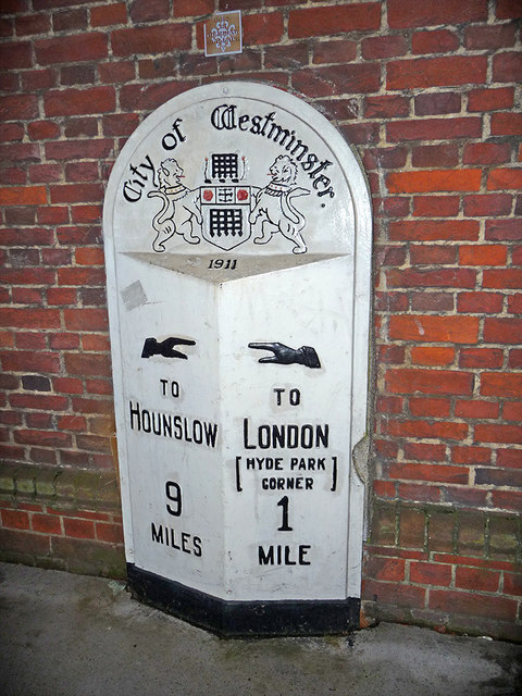
[edit].jpg)
The Irish mile (míle or míle Gaelach) measured 2,240 yards: approximately 1.27 statute miles or 2.048 kilometres.[43][44] It was used in Ireland from the 16th century plantations until the 19th century, with residual use into the 20th century. The units were based on "English measure" but used a linear perch measuring 7 yards (6.4 m) as opposed to the English rod of 5.5 yards (5.0 m).[44]
Italian
[edit]The Italian mile (miglio, pl. miglia) was traditionally considered a direct continuation of the Roman mile, equal to 1000 paces,[45] although its actual value over time or between regions could vary greatly.[46] It was often used in international contexts from the Middle Ages into the 17th century[45] and is thus also known as the "geographical mile",[47] although the geographical mile is now a separate standard unit.
Japanese
[edit]The CJK Compatibility Unicode block contains square-format versions of Japanese names for measurement units as written in katakana script. Among them, there is U+3344 ㍄ SQUARE MAIRU, after マイル mairu.
Ottoman
[edit]The Ottoman mile was 1,894.35 m, which was equal to 5,000 Ottoman foot. After 1933, the Ottoman mile was replaced with the modern Turkish mile (1,853.181 m).
Portuguese
[edit]The Portuguese mile (milha) used in Portugal and Brazil was 2.0873 km prior to metrication.[48]
Russian
[edit]The Russian mile (миля or русская миля, russkaya milya) was 7.468 km, divided into 7 versts.
Saxon
[edit]The Saxon post mile (kursächsische Postmeile or Polizeimeile, introduced on occasion of a survey of the Saxon roads in the 1700s, corresponded to 2,000 Dresden rods, equivalent to 9.062 kilometres.[49]
Old Scandinavian
[edit]The old Scandinavian miles (Norse: mil, [miːl], Finnish: peninkulma) were a number of measurements of length used in Scandinavia prior to the adoption of the modern "Scandinavian metric mile" (10 km) in the late 19th century.
Before the Renaissance, there were various regional miles in Scandinavia. In Sweden, the regional miles were eventually divided after province, so called landskapsmil (roughly "county miles").[50][51][52] Some noteworthy Swedish county miles are:
- Dala mile – 14,485 m (9.00 mi)
- Finnish mile (peninkulma) – around 6 km (3.73 mi)
- Småland mile – around 7 km (4.35 mi)
- Uppland mile – 10,688.54 m (6.64 mi) = 3,600 Swedish rods = 6,000 Swedish fathoms = 18,000 Swedish ells = 36,000 Swedish feet
- Västgöta mile – around 13 km (8.08 mi)
- Ångermanland mile – 11,875 m (7.38 mi) = 6,666 Swedish fathoms
While Denmark eventually adopted the Prussian mile (see § Danish mile), the Swedish kept their indigenous miles. In 1649 the Swedish government made the Uppland mile the de facto Swedish mile, or "unit mile" (enhetsmil), for all of Sweden, also called the "land mile" or "long mile". In Finland, then part of Sweden, their measurement peninkulma (which is translated as "mile") then became equivelant to the Swedish "unit mile", which later carried over when Finland seceded to the Russian Empire in 1809. When Norway became part of Sweden in 1814, forming the Union between Sweden and Norway, the Swedish standard for defining a "unit mile", 36,000 feet, was introduced to Norway, which, due to the Norwegian foot being slightly longer than the Swedish foot, then became slightly longer than in Sweden, making the "unit mile" 11.298 kilometres (7.020 miles) in Norway.
Upon metrification, Finland, Norway, and Sweden, decided to redefine their miles as 10 kilometres (6.2 mi), since they were all based on the old Swedish "unit mile", already close to the measurent. The modern Scandinavian (metric) mile is still a unit of length common in Norway and Sweden, to a lesser extent in Finland, but not Denmark.
The Scandinavians also had their own "nautical mile", called "sea mile" (Danish: sømil, Norwegian: sjømil, Swedish: sjömil), or the equivelant "sea-peninkulma" in Finnish (Finnish: meripeninkulma), equivelant to the German geographical mile (1⁄15 degrees of latitude), around 7,413 m (24,321 ft); later, during metrification, standardized as 7,420 m (24,340 ft).
Scots
[edit]
The Scots mile was longer than the English mile,[54] as mentioned by Robert Burns in the first verse of his poem "Tam o' Shanter". It comprised 8 (Scots) furlongs divided into 320 falls or faws (Scots rods).[55] It varied from place to place but the most accepted equivalencies are 1,976 Imperial yards (1.123 statute miles or 1.81 km). It was legally abolished three times: first by a 1685 act of the Scottish Parliament,[56] again by the 1707 Treaty of Union with England,[57] and finally by the Weights and Measures Act 1824.[54] It had continued in use as a customary unit through the 18th century but had become obsolete by its final abolition.
Welsh
[edit]The Welsh mile (milltir or milldir) was 3 statute miles and 1,470 yards long (6.17 km). It comprised 9,000 paces (cam), each of 3 Welsh feet (troedfedd) of 9 inches (modfeddi).[58] (The Welsh inch is usually reckoned as equivalent to the English inch.) Along with other Welsh units, it was said to have been codified under Dyfnwal the Bald and Silent and retained unchanged by Hywel the Good.[59] Along with other Welsh units, it was discontinued following the conquest of Wales by Edward I of England in the 13th century.
International
[edit]The international mile is precisely equal to 1.609344 km (or 25146/15625 km as a fraction).[61] It was established as part of the 1959 international yard and pound agreement reached by the United States, the United Kingdom, Canada, Australia, New Zealand, and the Union of South Africa,[62] which resolved small but measurable differences that had arisen from separate physical standards each country had maintained for the yard.[63] As with the earlier statute mile, it continues to comprise 1,760 yards or 5,280 feet.
The difference from the previous standards was 2 ppm, or about 3.2 millimetres (1⁄8 inch) per mile. The US standard was slightly longer and the old Imperial standards had been slightly shorter than the international mile. When the international mile was introduced in English-speaking countries, the basic geodetic datum in America was the North American Datum of 1927 (NAD27). This had been constructed by triangulation based on the definition of the foot in the Mendenhall Order of 1893, with 1 foot = 1200/3937 (≈0.304800609601) metres and the definition was retained for data derived from NAD27, but renamed the US survey foot to distinguish it from the international foot.[64][n 5] Thus a survey mile = 1200/3937 × 5280 (≈1609.347218694) metres. An international mile = 1609.344 / (1200/3937 × 5280) (=0.999998) survey miles.
The exact length of the land mile varied slightly among English-speaking countries until the international yard and pound agreement in 1959 established the yard as exactly 0.9144 metres, giving a mile of exactly 1,609.344 metres. The US adopted this international mile for most purposes, but retained the pre-1959 mile for some land-survey data, terming it the U. S. survey mile. In the United States, statute mile normally refers to the survey mile,[65] about 3.219 mm (1⁄8 inch) longer than the international mile (the international mile is exactly 0.0002% less than the US survey mile).
While many countries abandoned the mile when switching to the metric system, the international mile continues to be used in some countries, such as Liberia, Myanmar,[66] the United Kingdom[67] and the United States.[68] It is also used in a number of territories with less than a million inhabitants, most of which are UK or US territories, or have close historical ties with the UK or US: American Samoa,[69] Bahamas,[70] Belize,[71] British Virgin Islands,[72] Cayman Islands,[73] Dominica,[73] Falkland Islands,[74] Grenada,[75] Guam,[76] The N. Mariana Islands,[77] Samoa,[78] St. Lucia,[79] St. Vincent & The Grenadines,[80] St. Helena,[81] St. Kitts & Nevis,[82] the Turks & Caicos Islands,[83] and the US Virgin Islands.[84] The mile is even encountered in Canada, though this is predominantly in rail transport and horse racing, as the roadways have been metricated since 1977.[85][86][87][88] Ireland gradually replaced miles with kilometres, including in speed measurements; the process was completed in 2005.
US survey
[edit]The US survey mile is 5,280 US survey feet, or 1,609.347 metres and 0.30480061 metres respectively.[89] Both are very slightly longer than the international mile and international foot. In the United States, the term statute mile formally refers to the survey mile,[3] but for most purposes, the difference of less than 1⁄8 inch (3.2 mm) between the survey mile and the international mile (1609.344 metres exactly) is insignificant—one international mile is 0.999998 US survey miles—so statute mile can be used for either. But in some cases, such as in the US State Plane Coordinate Systems (SPCSs), which can stretch over hundreds of miles,[90] the accumulated difference can be significant, so it is important to note that the reference is to the US survey mile.
The United States redefined its yard in 1893, and this resulted in US and Imperial measures of distance having very slightly different lengths.
The North American Datum of 1983 (NAD83), which replaced the NAD27, is defined in metres. State Plane Coordinate Systems were then updated, but the National Geodetic Survey left individual states to decide which (if any) definition of the foot they would use. All State Plane Coordinate Systems are defined in metres, and 42 of the 50 states only use the metre-based State Plane Coordinate Systems. However, eight states also have State Plane Coordinate Systems defined in feet, seven of them in US survey feet and one in international feet.[90]
State legislation in the US is important for determining which conversion factor from the metric datum is to be used for land surveying and real estate transactions, even though the difference (2 ppm) is hardly significant, given the precision of normal surveying measurements over short distances (usually much less than a mile). Twenty-four states have legislated that surveying measures be based on the US survey foot, eight have legislated that they be based on the international foot, and eighteen have not specified which conversion factor to use.[90]
SPCS 83 legislation refers to state legislation that has been passed or updated using the newer 1983 NAD data. Most states have done so. Two states, Alaska and Missouri, and two jurisdictions, Guam and Puerto Rico, do not specify which foot to use.[90] Two states, Alabama and Hawaii, and four jurisdictions, Washington, DC, US Virgin Islands, American Samoa and Northern Mariana Islands, do not have SPCS 83 legislation.[90]
In October 2019, US National Geodetic Survey and National Institute of Standards and Technology announced their joint intent to retire the US survey foot and US survey mile, as permitted by their 1959 decision, with effect on January 1, 2023.[91][92][93]
Nautical
[edit]International nautical
[edit]
Each circle shown is a great circle—the analogue of a line in spherical trigonometry—and hence the shortest path connecting two points on the globular surface. Meridians are great circles that pass through the poles.
The nautical mile (historically also (sea mile) was originally defined as one minute of arc along a meridian of the Earth.[94] Navigators use dividers to step off the distance between two points on the navigational chart, then place the open dividers against the minutes-of-latitude scale at the edge of the chart, and read off the distance in nautical miles.[95] The Earth is not perfectly spherical but an oblate spheroid, so the length of a minute of latitude increases by 1% from the equator to the poles, as seen for example in the WGS84 ellipsoid, with 1,843 metres (6,046 ft) at the equator, 1,862 metres (6,108 ft) at the poles and average 1,852 metres (6,076 ft).
Since 1929 the international nautical mile is defined by the First International Extraordinary Hydrographic Conference in Monaco as exactly 1,852 metres (which is 1.151 miles or 6,076.12 feet).[96] In the United States, the nautical mile was defined in the 19th century as 6,080.2 feet (1,853.24 m), whereas in the United Kingdom, the Admiralty nautical mile was defined as 6,080 feet (1,853.18 m) and was about one minute of latitude in the latitudes of the south of the UK. Other nations had different definitions of the nautical mile.
Related units
[edit]The nautical mile per hour is known as the knot. Nautical miles and knots are almost universally used for aeronautical and maritime navigation, because of their relationship with degrees and minutes of latitude and the convenience of using the latitude scale on a map for distance measuring.
The data mile is used in radar-related subjects and is equal to 6,000 feet (1.8288 kilometres).[97] The radar mile is a unit of time (in the same way that the light year is a unit of distance), equal to the time required for a radar pulse to travel a distance of two miles (one mile each way). Thus, the radar statute mile is 10.8 μs and the radar nautical mile is 12.4 μs.[98]
Scandinavian nautical
[edit]Scandinavians used their own version of the "nautical mile" up to the beginning of the 20th century (with continued regional use), indigenously known as a sea mile (Danish: sømil, Norwegian: sjømil, Swedish: sjömil), or the equivelant "sea-peninkulma" in Finnish (Finnish: meripeninkulma). It was equal to a "geographical mile", defined as 1⁄15 of an equatorial degree (1⁄360° of longitude),[99] equivalent to approximately four modern nautical miles or "medium meridian minutes" (4 × 1,852 m) – a nautical mile is approximately one sixtieth of a degree along a meridian (1/60 meridian degree).
During metrification in 1875, this brought it down to about 7,420 m (24,340 ft) from its former equivalence of 3950 fathoms (Bokmål: favn, Swedish: famn) or about 7,435 m (24,393 ft).
Geographical
[edit]The geographical mile is based upon the length of a meridian of latitude. The German geographical mile (geographische Meile) was previously 1⁄15° of latitude (7.4127 km),[100] and was used as the basis for the Scandinavian nautical mile.
Metric
[edit]The informal term "metric mile" is used in some countries, in sports such as track and field athletics and speed skating, to denote a distance of 1,500 metres (0.932 miles). The 1500 meters is the premier middle distance running event in Olympic sports. In United States high-school competition, the term is sometimes used for a race of 1,600 metres (0.994 miles).[101]
Metric mile has also been used to denote other metric measurements under the name mile, such as the Scandinavian mile (Swedish: metrisk mil),[102] and previously also the kilometre, in Dutch.
Scandinavian metric
[edit]The Scandinavian metric mile (Norwegian and Swedish: mil, [miːl]) refers to the modern Scandinavian mile, used in Norway and Sweden, to a lesser extent in Finland (Finnish: peninkulma), but not in Denmark, which since metrication in the late 19th century is standardized as 10 km.[25] It is used in informal situations and in measurements of fuel consumption, which are often given as litres per mil. In formal situations (such as official road signs) only kilometres are given.
The Scandinavian metric mile is based of the old Swedish "unit mile" (Swedish: enhetsmil), which was standardised as 36,000 Swedish feet or 10.6884 kilometres (6.6415 miles) in 1649; before that, the mile varied by province from about 6–14.485 km (3.728–9.001 mi), also known as "county miles" (Swedish: landskapsmil).[25] In Finland, then part of Sweden, the traditional Finnish measurement peninkulma, or "Finnish mile" (Swedish: finsk mil), became redefined as equivelant to the Swedish "unit mile" Swedish: mil, which was then kept when Finland seceded to Russia in 1809. When Norway became part of Sweden in 1814, forming the Union between Sweden and Norway, the Swedish standard for defining a mile was introduced, which then became slightly longer in Norway than in Sweden, due to the Norwegian foot being slightly longer than the Swedish foot, making the "unit mile" 11.298 kilometres (7.020 miles) in Norway. Upon metrification, each country decided to redefine their mile to 10 kilometres.
Comparison table
[edit]A comparison of the different lengths for a "mile", in different countries and at different times in history, is given in the table below. Leagues are also included in this list because, in terms of length, they fall in between the short West European miles and the long North, Central and Eastern European miles.
| Length (m) | Name | Country used | From | To | Definition | Remarks |
|---|---|---|---|---|---|---|
| 500 | lǐ | mainland China | 1984 | today | 1,500 chi | In Chinese, this unit and the imperial mile are written using the same word (里), with a qualifier to distinguish between systems if needed |
| 960–1,152 | Talmudic mil | Land of Israel/Canaan | today | 2,000 amot (cubits) | Biblical and Talmudic units of measurement | |
| 1,480 | mille passus, milliarium | Roman Empire | Ancient Roman units of measurement | |||
| 1,486.6 | miglio[103] | Sicily | ||||
| 1,524 | London mile | England | ||||
| 1,609.3426 | (statute) mile | England/UK | 1592 | 1959 | 1,760 yards | Over the course of time, the length of a yard changed several times and consequently so did the English, and from 1824, the imperial mile. The statute mile was introduced in 1592 during the reign of Queen Elizabeth I |
| 1,609.344 | mile | some English speaking countries[citation needed] | 1959 | today | 1,760 yards | On 1 July 1959, the imperial mile was standardized to an exact length in metres. This figure corresponds to 5280 feet at 25.4 millimeters per inch. |
| 1,609.3472 | (statute) mile | United States | 1893 | 2022 | 1,760 yards | From 1959 also called the US Survey Mile. From then, its only utility has been land survey, before it was the standard mile. From 1893, its exact length in metres was: 3600/3937 × 1760 |
| 1,807 | Scots mile | Scotland | 1685 | 5,920 feet | ||
| 1,820 | Italy | |||||
| 1,852 | nautical mile | international | today | approx. 1 minute of arc | Measured at a circumference of 40,000 km. Abbreviation: NM, nm | |
| 1,852.3 | (for comparison) | 1 meridian minute | ||||
| 1,853.181 | nautical mile | Turkey | ||||
| 1,855.4 | (for comparison) | 1 equatorial minute | Although the NM was defined on the basis of the minute, it varies from the equatorial minute, because at that time the circumference of the equator could only be estimated at 40,000 km. | |||
| 2,065 | Portugal | |||||
| 2,220 | Gallo-Roman league | Gallo-Roman culture | 1.5 miles | Under the reign of Emperor Septimius Severus, this replaced the Roman mile as the official unit of distance in the Gallic and Germanic provinces, although there were regional and temporal variations.[104] | ||
| 2,470 | Sardinia, Piemont | |||||
| 2,622 | Scotland | |||||
| 2,880 | Ireland | |||||
| 3,780 | Flanders | |||||
| 3,898 | French lieue (post league) | France | 2,000 "body lengths" | |||
| 3,927 | Ri | Japan | 12,960 shaku | |||
| 4,000 | general or metric league | |||||
| 4,000 | legue | Guatemala | ||||
| 4,190 | legue | Mexico[105] | = 2,500 tresas = 5,000 varas | |||
| 4,444.8 | landleuge | 1⁄25° of a circle of longitude | ||||
| 4,452.2 | lieue commune | France | Units of measurement in France before the French Revolution | |||
| 4,513 | legue | Paraguay | ||||
| 4,513 | legua | Chile,[105] (Guatemala, Haiti) | = 36 cuadros = 5,400 varas | |||
| 4,808 | Switzerland | |||||
| 4,828 | English land league | England | 3 miles | |||
| 4,800 4,900 |
Germanic rasta, also doppelleuge (double league) |
|||||
| 5,000 | légua nova | Portugal[105] | ||||
| 5,196 | legua | Bolivia[105] | = 40 ladres | |||
| 5,152 | legua Argentina | Argentina, Buenos Aires[105] | = 6,000 varas | |||
| 5,154 | legue | Uruguay | ||||
| 5,200 | Bolivian legua | Bolivia | ||||
| 5,370 | legue | Venezuela | ||||
| 5,500 | Portuguese legua | Portugal | ||||
| 5,510 | legue | Ecuador | ||||
| 5,510 | Ecuadorian legua | Ecuador | ||||
| 5,532.5 | Landleuge (state league) |
Prussia | Obsolete German units of measurement | |||
| 5,540 | legue | Honduras | ||||
| 5,556 | Seeleuge (nautical league) | 1⁄20° of a circle of longitude 3 nautical miles |
||||
| 5,570 | legua | Spain and Chile | Spanish customary units | |||
| 5,572 | legua | Colombia[105] | = 3 Millas | |||
| 5,572.7 | legue | Peru[105] | = 20,000 feet | |||
| 5,572.7 | legua Antigua old league |
Spain[105] | = 3 millas = 15,000 feet | |||
| 5,590 | légua | Brazil[105] | = 5,000 varas = 2,500 bracas | |||
| 5,600 | Brazilian legua | Brazil | ||||
| 5,685 | Fersah (Turkish league) | Ottoman Empire | 1933 | 4 Turkish miles | Derived from Persian parasang | |
| 5,840[106] | Dutch mile | Holland | ||||
| 6,170 | milltir | Wales | 13thC | 9,000 camau ( = 27,000 troedfeddi = 243,000 inches) | Eclipsed by the conquest of Wales by Edward I | |
| 6,197 | légua antiga | Portugal[105] | = 3 milhas = 24 estadios | |||
| 6,240 | Persian legue | Persia | ||||
| 6,277 | Luxembourg | |||||
| 6,280 | Belgium | |||||
| 6,687.24 | legua nueva new league, since 1766 |
Spain[105] | = 8,000 varas | |||
| 6,700 | Breslau mile | Silesia | 1630 | 1872 | Also known as mila wrocławska in Polish | |
| 6,797 | Landvermessermeile (state survey mile) |
Saxony | Obsolete German units of measurement | |||
| 7,400 | Netherlands | |||||
| 7,409 | (for comparison) | 4 meridian minutes | ||||
| 7,419.2 | Kingdom of Hanover | Obsolete German units of measurement | ||||
| 7,419.4 | Duchy of Brunswick | Obsolete German units of measurement | ||||
| 7,420.4 7,414.9 |
Bavaria | Obsolete German units of measurement | ||||
| 7,420.439 | geographic mile | 1⁄15 equatorial grads [dubious – discuss] | ||||
| 7,421.6 | (for comparison) | 4 equatorial minutes | ||||
| 7,448.7 | Württemberg | Obsolete German units of measurement | ||||
| 7,450 | Hohenzollern | Obsolete German units of measurement | ||||
| 7,467.6 | Russia | 7 verst | Obsolete Russian units of measurement | |||
| 7,480 | Bohemia | |||||
| 7,500 | kleine / neue Postmeile (small/new postal mile) |
Saxony | 1840 | German Empire, North German Confederation, Grand Duchy of Hesse, Russia. Obsolete German units of measurement | ||
| 7,532.5 | Land(es)meile (German state mile) |
Denmark, Hamburg, Prussia | Primarily for Denmark defined by Ole Rømer. Obsolete German units of measurement | |||
| 7,585.9 | Postmeile (post mile) |
Austro-Hungary | Austrian units of measurement | |||
| 7,850 | Milă | Romania | ||||
| 8,534.31 | Mila | Poland | 1819 | 7146 meters before 1819, also equaled 7 verst[107] | ||
| 8,800 | Schleswig-Holstein | Obsolete German units of measurement | ||||
| 8,888.89 | Baden | Obsolete German units of measurement | ||||
| 9,062 | mittlere Post- / Polizeimeile (middle post mile or police mile) |
Saxony | 1722 | Obsolete German units of measurement | ||
| 9,206.3 | Electorate of Hesse | Obsolete German units of measurement | ||||
| 9,261.4 | (for comparison) | 5 meridian minutes | ||||
| 9,277 | (for comparison) | 5 equatorial minutes | ||||
| 9,323 | alte Landmeile (old state mile) |
Hanover | 1836 | Obsolete German units of measurement | ||
| 9,347 | alte Landmeile (old state mile) |
Hanover | 1836 | Obsolete German units of measurement | ||
| 9,869.6 | Oldenburg | |||||
| 10,000 | metric mile, Scandinavian mile | Norway, Sweden | today | Still commonly used today, e.g. for road distances; equates to the myriametre | ||
| 10,044 | große Meile (great mile) |
Westphalia | Obsolete German units of measurement | |||
| 10,670 | Finland | |||||
| 10,688.54 | mil | Sweden | 1889 | In normal speech, "mil" means a Scandinavian mile of 10 km. | ||
| 11,113.7 | (for comparison) | 6 meridian minutes | ||||
| 11,132.4 | (for comparison) | 6 equatorial minutes | ||||
| 11,299 | mil | Norway | was equivalent to 3,000 Rhenish rods. |
Similar units:
- 1,066.8 m – verst, see also obsolete Russian units of measurement
Idioms
[edit]The mile is still used in a variety of idioms, even in English-speaking countries that have moved from the Imperial to the metric system (for example, Australia, Canada, or New Zealand). These idioms include:
- A country mile is used colloquially to denote a very long distance
- "A miss is as good as a mile" (failure by a narrow margin is no better than any other failure)
- "Give him an inch and he'll take a mile" – a corruption of "Give him an inch and he'll take an ell"[108][109] (the person in question will become greedy if shown generosity)
- "Missed by a mile" (missed by a wide margin)
- "Go a mile a minute" (move very quickly)
- "Talk a mile a minute" (speak at a rapid rate)
- "To go the extra mile" (to put in extra effort)
- "Miles away" (lost in thought, or daydreaming)
- "Milestone" (an event indicating significant progress)
- Glasgow's miles better, a touristic campaign.
See also
[edit]Notes
[edit]- ^ Exactly 50292/57875 nmi
- ^ A partitive genitive construction literally meaning "one thousand of paces".[8]
- ^ The c. 1300 Composition of Yards and Perches, a statute of uncertain date usually reckoned as an enactment of Edward I[33] or II,[32] notionally continued to derive English units from three barleycorns "dry and round" to the inch[33] and this statute remained in force until the 1824 Weights and Measures Act establishing the Imperial system. In practice, official measures were verified using the standards at the Exchequer or simply ignored.[34]
- ^ "Pole" being another name for the rod.
- ^ When reading the document it helps to bear in mind that 999,998 = 3,937 × 254.
References
[edit]Citations
[edit]- ^ OED (2002), "mile, n.1".
- ^ AHD (2006), "mile, 1".
- ^ a b Thompson (2008), B.6..
- ^ Weintrit, Adam (24 October 2019). "History of the Nautical Mile". Logistyka. Archived from the original on 1 March 2018. Retrieved 24 October 2019.
- ^ Butcher (2014), p. C-16.
- ^ "Road traffic: The traffic signs regulations and general directions 2015" (PDF). Government of the United Kingdom. Archived (PDF) from the original on 21 September 2018. Retrieved 20 September 2018.
- ^ "Numbers" Archived 27 July 2018 at the Wayback Machine BBC
- ^ Lease (1905), p. 211.
- ^ Bassett, David R.; Mahar, Matthew T.; Rowe, David A.; Morrow, James R. (2008). "Walking and Measurement". Medicine & Science in Sports & Exercise. 40 (7): S529 – S536. doi:10.1249/MSS.0b013e31817c699c. ISSN 0195-9131. PMID 18562970.
- ^ Soren (1999), p. 184.
- ^ Shuttleworth.
- ^ Smith (1875), p. 762.
- ^ "Measurement". Maths History. Retrieved 1 September 2025.
- ^ Lesley Adkins; Roy A. Adkins; Both Professional Archaeologists Roy A Adkins (14 May 2014). Handbook to Life in Ancient Rome. Infobase Publishing. pp. 199–. ISBN 978-0-8160-7482-2.
- ^ Shcheglov, Dmitry A. (2017). "Eratosthenes' Contribution to Ptolemy's Map of the World". Imago Mundi. 69 (2): 159–175. doi:10.1080/03085694.2017.1312112. ISSN 0308-5694. JSTOR 48547828.
- ^ Russo, Lucio (6 February 2013). "Ptolemy's longitudes and Eratosthenes' measurement of the earth's circumference". Mathematics and Mechanics of Complex Systems. 1 (1): 67–79. doi:10.2140/memocs.2013.1.67. ISSN 2325-3444.
- ^ Ptolemy; Berggren, J. Lennart; Jones, Alexander (15 January 2002). Ptolemy's Geography: An Annotated Translation of the Theoretical Chapters. Princeton University Press. ISBN 978-0-691-09259-1.
- ^ Serim (31 July 2018). "The Arabic Translations of Ptolemy's Almagest". www.qdl.qa. Retrieved 28 May 2025.
- ^ "Maps and Map-making in India | Al-Idrisi to Ptolemy: Early Maps of India · Online Exhibits". apps.lib.umich.edu. Retrieved 29 May 2025.
- ^ Jan Harasimowicz; Włodzimierz Suleja, eds. (2000). Encyklopedia Wrocławia (Wyd. 1 ed.). Wrocław: Wydawn. Dolnośląskie. ISBN 83-7023-749-5. OCLC 46420892.
- ^ Davies, Norman (2002). Mikrokosmos : portret miasta środkowoeuropejskiego: Vratislava, Breslau, Wrocław. Roger Moorhouse, Andrzej Pawelec (Wyd. 1 ed.). Kraków: Wydawn. Znak. ISBN 83-240-0172-7. OCLC 50928641.
- ^ (in Croatian) "Centuries of Natural Science in Croatia : Theory and Application" Archived 2 January 2009 at the Wayback Machine. Kartografija i putopisi.
- ^ Viličić, Marina; Lapaine, Miljenko (2016). "Hrvatska milja na starim kartama" [The Croatian Mile on Old Maps] (PDF). Kartografija I Geoinformacije (in Croatian and English). 15 (25). Zagreb: Croatian Cartographic Society: 4–22. Archived from the original on 8 July 2019. Retrieved 8 July 2019.
- ^ Opačić, Nives (23 February 2003). "Mrvice s banskoga stola". Vijenac (in Croatian). No. 232. Zagreb: Matica hrvatska. Archived from the original on 14 February 2020. Retrieved 8 July 2019.
- ^ a b c Rowlett (2018), "mil 4".
- ^ Apian, Petrus (1545). Cosmographie, oft Beschryvinghe der geheelder werelt. de Bonte. p. xvii. Retrieved 18 November 2023.
- ^ Metius, Adriaan Adriaansz (1627). Fundamentale onderwijsinghe, aengaende de fabrica en het veelvoudigh gebruyck van het Astrolabium, soo catholicum als particulier. Netherlands: gedr. bij U. Balck. p. 163. Retrieved 18 November 2023.
- ^ Andrews (2003), p. 70.
- ^ a b Evans (1975), p. 259.
- ^ Chaney (1911), p. 484.
- ^ a b c Klein (1988), p. 69.
- ^ a b c d e Chisholm (1864), p. 8.
- ^ a b c NPL.
- ^ Chisholm (1864), p. 37.
- ^ Chisholm (1864), p. 4.
- ^ Zupko (1977), pp. 10–11, 20–21.
- ^ Burke (1978), Ch. 9.
- ^ Adams (1990).
- ^ Statutes at large from the first year of King Edward the fourth to the end of the reign of Queen Elizabeth. Vol. II. 1763. p. 676. Retrieved 29 November 2011.
- ^ Act 35 Eliz. I cap. 6, s. 8.[39]
- ^ Norgate (1998).
- ^ Morden (1695).
- ^ Rowlett (2018), "Irish mile".
- ^ a b Ordnance Survey Ireland. "Frequently Asked Questions". Archived from the original on 28 February 2012. Retrieved 17 February 2009.
- ^ a b De Morgan (12 February 1842). "XXXIV On Fernel's Measure of a Degree, in reply to Mr. Galloway's Remarks". The London, Edinburgh and Dublin Philosophical Magazine and Journal of Science. Taylor & Francis: 230–233. Archived from the original on 20 November 2023. Retrieved 10 March 2023.
- ^ Zupko (1981), "Miglio".
- ^ Young, Norwood, ed. (1908). Handbook for Rome and the Campagna. Murray's Handbooks. E. Stanford. p. 29. Archived from the original on 20 November 2023. Retrieved 10 March 2023.
- ^ Rowlett (2018), "milha".
- ^ "Historie der Postsäulen" (in German). Forschungsgruppe Kursächsische Postmeilensäulen e.V. und 1. Sächsischer Postkutschenverein e.V. Archived from the original on 5 February 2017. Retrieved 5 February 2017.
- ^ snl.no
- ^ Old Swedish Units of Measurement - Linear Measure
- ^ Suureet ja yksiköt. SI-mittayksikköjärjestelmäQuantities and units. The International System of Units (SI)
- ^ Edinburgh 2000 visitors' guide. Collins. 1999. p. 31. ISBN 978-0-004-49017-5.
- ^ a b "mile". Dictionary of the Scottish Language – Scottish National Dictionary. Archived from the original on 4 August 2020. Retrieved 14 April 2020.
- ^ "fall, faw". Dictionary of the Scottish Language – Dictionary of the Older Scottish Tongue. Archived from the original on 4 August 2020. Retrieved 14 April 2020.
- ^ "Act for a standard of miles". Records of the Parliaments of Scotland. Edinburgh. 23 April 1685. APS viii: 494 c.59. Archived from the original on 10 March 2023. Retrieved 10 March 2023.
- ^ "Act ratifying and approving the treaty of union of the two kingdoms of Scotland and England". Records of the Parliaments of Scotland. Edinburgh. 3 October 1706. Archived from the original on 10 March 2023. Retrieved 10 March 2023.
- ^ Owen (1841), Book II, Ch. XVII, §5.
- ^ Owen (1841), Book II, Ch. XVII, §2.
- ^ "Schedule I, Part VI", Weights & Measures Act of 1985, archived from the original on 27 November 2011, retrieved 7 July 2011.
- ^ 1,760 yards × 0.9144 m/yard.[60]
- ^ Barbrow (1976), pp. 16–17, 20.
- ^ Bigg (1964).
- ^ Astin (1959).
- ^ Convert mile [statute] to mile [statute, US] Archived 20 February 2015 at the Wayback Machine "1 metre is equal to 0.000621371192237 mile [statute], or 0.000621369949495 mile [statute, US]. ... The U.S. statute mile (or survey mile) is defined by the survey foot. This is different from the international statute mile, which is defined as exactly 1609.344 metres. The U.S. statute mile is defined as 5,280 U.S. survey feet, which is around 1609.347219 metres."
- ^ File:Naypyitaw Tollbooth.jpg
- ^ "The Units of Measurement Regulations 1995", legislation.gov.uk, The National Archives, SI 1995/1804
- ^ Maximum posted speed limits Archived 23 September 2011 at the Wayback Machine (US) IIHS. Retrieved 14 September 2011
- ^ Hayner, Jeff (29 November 2012). "ASAA planning 1.2-mile swim in Pago Pago harbor". Samoa News. Archived from the original on 29 October 2013. Retrieved 18 January 2014.
- ^ "The Nassau Guardian". 29 August 2012. Archived from the original on 29 October 2013. Retrieved 18 January 2014.
- ^ Jerome Williams (30 August 2013). "Pawpa Brown Race results". Amandala.com.bz. Archived from the original on 29 October 2013. Retrieved 18 January 2014.
- ^ "Mt. bikers compete in Anegada". Bvibeacon.com. 8 May 2013. Archived from the original on 29 October 2013. Retrieved 18 January 2014.
- ^ a b "Paddling 300 miles for NCVO". Cayman Compass. 4 June 2013. Archived from the original on 29 October 2013. Retrieved 18 January 2014.
- ^ "Bronze medal for Falklands football at Island Games in Bermuda". Penguin-news.com. 24 July 2013. Archived from the original on 24 September 2015. Retrieved 18 January 2014.
- ^ "Find the culprit!!!". Spicegrenada.com. Archived from the original on 16 September 2013. Retrieved 18 January 2014.
- ^ "Navy evacuates patient from cruise ship 50 miles off Guam". Pacific Daily News. 9 March 2013. Archived from the original on 16 September 2013. Retrieved 18 January 2014.
- ^ "Saipan Tribune". 23 September 2013. Archived from the original on 23 September 2013. Retrieved 10 March 2023.
- ^ "When you need to go". 23 September 2013. Archived from the original on 23 September 2013. Retrieved 10 March 2023.
- ^ "The Voice – The national newspaper of St. Lucia since 1885". Thevoiceslu.com. 8 February 2008. Archived from the original on 29 October 2013. Retrieved 18 January 2014.
- ^ "Peace Corps Volunteer runs 49 miles from Petit Bordel to Georgetown". Searchlight.vc. 16 December 2011. Archived from the original on 29 October 2013. Retrieved 18 January 2014.
- ^ "And I would walk 50 miles..." Sthelenaonline.org. 7 October 2012. Archived from the original on 22 March 2014. Retrieved 18 January 2014.
- ^ "104 Square Miles, but is it ours?". The St. Kitts-Nevis Observer. 28 September 2012. Archived from the original on 1 February 2013. Retrieved 18 January 2014.
- ^ "Provo has a new club". Suntci.com. 15 July 2009. Archived from the original on 29 October 2013. Retrieved 18 January 2014.
- ^ AARON GRAY (Daily News Staff) (27 February 2012). "Butler outduels archrival to win 8 Tuff Miles". Virgin Islands Daily News. Archived from the original on 16 September 2013. Retrieved 18 January 2014.
- ^ Branch, Legislative Services (19 April 2021). "Consolidated federal laws of Canada, Weights and Measures Act". laws-lois.justice.gc.ca. Archived from the original on 10 March 2023. Retrieved 10 March 2023.Act current to 18 January 2012. Canadian units (5) The Canadian units of measurement are as set out and defined in Schedule II, and the symbols and abbreviations therefor are as added pursuant to subparagraph 6(1)(b)(ii).
- ^ Weights and Measures Act Archived 16 October 2012 at the Wayback Machine
- ^ Government of Canada, Transportation Safety Board of Canada (26 October 2011). "Railway Investigation Report R10E0096 - Transportation Safety Board of Canada". www.tsb.gc.ca. Archived from the original on 14 September 2022. Retrieved 10 March 2023.February 2012, Rail Report – 2010 – Report Number R10E0096. Other Factual Information (See Figure 1). 2. Assignment 602 travelled approximately 12 car lengths into track VC-64 and at a speed of 9 mph struck a stationary cut of 46 empty cars (with the air brakes applied) that had been placed in the track about 2+1⁄2 hours earlier. Canadian railways have not been metricated and therefore continue to measure trackage in miles and speed in miles per hour.
- ^ Hastings Racecourse Fact Book Archived 18 April 2012 at the Wayback Machine Like Canadian railways, Canadian race tracks have not been metricated and continue to measure distance in miles, furlongs, and yards (see page 18 of the fact book).
- ^ "Appendix E. General Tables of Units of Measurement". Retrieved 14 January 2020. (links to a Microsoft Word document)
- ^ a b c d e US National Geodetic Survey. "What are the 'official' conversions that are used by NGS to convert 1) metres to inches, and 2) metres to feet?". Frequently Asked Questions about the National Geodetic Survey. Archived from the original on 5 September 2015. Retrieved 16 May 2009.
- ^ "NGS and NIST to Retire U.S. Survey Foot after 2022". National Geodetic Survey. 31 October 2019. Archived from the original on 27 May 2021. Retrieved 4 March 2020.
- ^ "U.S. Survey Foot: Revised Unit Conversion Factors". NIST. 16 October 2019. Archived from the original on 2 March 2020. Retrieved 4 March 2020.
- ^ "Federal Register :: Request Access". 5 October 2020. Archived from the original on 21 December 2022. Retrieved 5 July 2022.
- ^ Maloney (1978), p. 34.
- ^ Maloney (1978), pp. 34–35.
- ^ International Bureau of Weights and Measures (2006), The International System of Units (SI) (PDF) (8th ed.), p. 127, ISBN 92-822-2213-6, archived (PDF) from the original on 4 June 2021, retrieved 16 December 2021.
- ^ Rowlett (2018), "data mile".
- ^ Rowlett (2018), "radar mile".
- ^ Store norske leksikon (in Norwegian)
- ^ Rowlett (2018), "meile".
- ^ Rowlett (2018), "mile".
- ^ Statistisk handbok för Finland. Andra upplagan – via Project Runeberg.
- ^ Leopold Carl Bleibtreu: Handbuch der Münz-, Maß- und Gewichtskunde und des Wechsel-Staatspapier-, Bank- und Aktienwesens europäischer und außereuropäischer Länder und Städte. Verlag von J. Engelhorn, Stuttgart, 1863, p. 332
- ^ R. C. A. Rottländer (January 2006). "Hierarchische Gliederung der vormetrischen Längeneinheiten". vormetrische-laengeneinheiten.de. Archived from the original on 22 February 2006. Retrieved 10 March 2023.
- ^ a b c d e f g h i j k Helmut Kahnt (1986), BI-Lexikon Alte Maße, Münzen und Gewichte, Leipzig: VEB Bibliographisches Institut, p. 380
- ^ IKAR-Altkartendatenbank[permanent dead link] der Staatsbibliothek zu Berlin, Kartenabteilung.
- ^ Gloger, Zygmunt (1898). Ksiega rzeczy polskich. Druk W.L. Anczyca i Sp. OL 23442814M.
- ^ Concise Oxford English Dictionary (5th edition; 1964). Oxford University Press.
- ^ John Heywood (1562). The proverbs, epigrams, and miscellanies of John Heywood ... Print. for subscribers, by the Early English Drama Society. pp. 95–. Retrieved 1 December 2011.
Sources
[edit]- Adams, Cecil (1990), "What's the origin of miles and yards?", The Straight Dope, archived from the original on 27 February 2015, retrieved 6 April 2015.
- The American Heritage Dictionary of the English Language (4 ed.), Boston: Houghton Mifflin Co., 2006 [Originally published 2001], ISBN 978-0-618-70172-8.
- Andrews, J.H. (15 September 2003), "Sir Richard Bingham and the Mapping of Western Ireland" (PDF), Proceedings of the Royal Irish Academy, vol. 103C, No. 3, Dublin: Royal Irish Academy, archived from the original (PDF) on 17 February 2012, retrieved 27 October 2011.
- Astin, A.V.; et al. (25 June 1959), Doc. 59-5442: Refinement of values for the yard and the pound (PDF), Washington, D.C.: National Bureau of Standards, archived (PDF) from the original on 21 August 2006, retrieved 2 November 2008.
- Barbrow, Louis E.; et al. (1976), Weights and Measures Standards of the United States—A Brief History (PDF), National Institute of Standards and Technology, doi:10.6028/NBS.SP.447, archived (PDF) from the original on 10 February 2023, retrieved 14 August 2020.
- Bigg, P.H.; et al. (1964), "The United Kingdom Standards of the Yard in Terms of the Metre", British Journal of Applied Physics, vol. 15, No. 3, pp. 291–300, Bibcode:1964BJAP...15..291B, doi:10.1088/0508-3443/15/3/308, archived from the original on 3 August 2012, retrieved 17 May 2009.
- Burke, James (1978), Connections, Little, Brown, & Co., ISBN 0-316-11685-8.
- Butcher, Tina, ed. (2014), "Appendix C", NIST Handbook 44: Specifications, Tolerances, and Other Technical Requirements for Weighing and Measuring Devices, archived from the original on 6 August 2016, retrieved 13 July 2017.
- Chaney, Henry James (1911). . In Chisholm, Hugh (ed.). Encyclopædia Britannica. Vol. 28 (11th ed.). Cambridge University Press. pp. 477–494.
- Chisholm, Henry Williams (11 March 1864), "No. 115: Letter from the Comptroller General of the Exchequer to the Treasury, Dated 3rd June 1863, Transmitting a Report on the Exchequer Standards of Weight and Measure, Dated 27th April 1863", Accounts and Papers: Session 4 February — 29 July 1864, vol. LVIII, London: Milner Gibson, p. 621
- Evans, I. M. (1975), "A Cartographic Evaluation of the Old English Mile", The Geographical Journal, 141 (2): 259–264, Bibcode:1975GeogJ.141..259E, doi:10.2307/1797211, JSTOR 1797211
- Klein, Herbert Arthur (1988) [Originally published 1974], The Science of Measurement: A Historical Survey, New York: Dover Publications (Previously published by Simon & Schuster as The World of Measurements: Masterpieces, Mysteries and Muddles of Metrology).
- Livy (1905), Lease, Emory Bair (ed.), Ab Urbe Condita, vol. I, XXI, & XXII, New York: University Publishing.
- Maloney, Elbert S. (1978), Dutton's Navigation and Piloting (13 ed.), Annapolis: Naval Institute Press.
- Morden, Robert (1695), Dorsetshire, archived from the original on 10 August 2011, retrieved 17 August 2011.
- "History of Length Measurement", Factsheets, Teddington: National Physical Laboratory, archived from the original on 18 April 2015, retrieved 12 April 2015.
- Norgate, Martin; et al. (1998), "Morden's Hampshire 1695", Old Hampshire Mapped, Hampshire County Council, ISBN 1-85975-134-2, archived from the original on 8 June 2011, retrieved 17 August 2011.
- Owen, Aneurin, ed. (1841), "The Venedotian Code", Ancient Laws and Institutes of Wales; Comprising Laws Supposed to be Enacted by Howel the Good, Modified by Subsequent Regulations under the Native Princes prior to the Conquest by Edward the First: And Anomalous Laws, Consisting Principally of Institutions which by the Statute of Ruddlan were Admitted to Continue in Force: With an English Translation of the Welsh Text, to which are Added A few Latin Transcripts, Containing Digests of the Welsh Laws, Principally of the Dimetian Code, London: Commissioners on the Public Records of the Kingdom. (in Welsh) & (in English)
- Oxford English Dictionary, 3rd ed., Oxford: Oxford University Press, 2002.
- Rowlett, Russ (2018), How Many? A Dictionary of Units of Measurement, Chapel Hill: University of North Carolina, retrieved 5 November 2019.
- Shuttleworth, M., Building Roman roads, Experiment Resources, archived from the original on 21 April 2011, retrieved 2 May 2011.
- Smith, William, ed. (1875), Dictionary of Greek and Roman Antiquities, London: John Murray.
- Soren, D.; et al. (1999), "A Roman villa and a late Roman infant cemetery : excavation at Poggio Gramignano, Lugnano in Teverina", Bibliotheca Archaeologica, Rome: L'Erma di Bretschneider.
- Thompson, Ambler; et al. (2008), Special Publication 811: Guide for the Use of the International System of Units (SI) (PDF), Gaithersburg: National Institute of Standards and Technology, archived (PDF) from the original on 3 June 2016, retrieved 19 September 2020.
- Zupko, Ronald Edward (1977), British weights & measures: a history from antiquity to the seventeenth century, University of Wisconsin Press, ISBN 978-0-299-07340-4, archived from the original on 26 July 2023, retrieved 26 November 2011.
- Zupko, Ronald Edward (1981), Italian Weights and Measures from the Middle Ages to the Nineteenth Century, Philadelphia: American Philosophical Society, ISBN 0-87169-145-0.
Further reading
[edit]- NIST General Tables of Units of Measurement, United States National Institute of Standards and Technology, archived from the original on 10 December 2011
- "Tafel zur Vergleichung und Bestimmung der Wegemaasse", Naturhistorische und chemischtechnische Notizen nach den neuesten Erfahrungen zur Nutzanwendung für Gewerbe, Fabrikwesen und Landwirthschaft, Expedition der Medicinischen Centralzeitung, 1856, pp. 320–326 (Item notes: Sammlung5-6 (1856–57) Original from Harvard University Digitized 9 January 2008)
- Smits, Jan (15 February 2013) [1996], Mathematical data for bibliographic descriptions of cartographic materials and spatial data, Personal page on website ICA Commission on Map Projections, archived from the original on 12 February 2014
- Wigglesworth Clarke, Frank (1875), Weights, measures, and money, of all nations, New York, D. Appleton & Company, p. 91
Etymology and Terminology
Etymology
The English word "mile" derives from the Latin phrase mille passus, meaning "a thousand paces," which originally denoted a distance equivalent to 1,000 Roman paces in ancient measurement systems.[3] This term emerged in the Roman military and administrative context, where a pace (passus) represented a double step taken by a marching soldier, establishing the mile as a practical unit for road distances and travel.[9] The word entered Old English as mīl around the pre-1150 period, inherited through Proto-West Germanic mīljō and influenced by broader Germanic borrowings from Latin milia passuum ("thousands of paces").[10] By the Middle English era (circa 1100–1500), it evolved into myle or mile, reinforced by Norman influences including Old French mile or mil, which itself stemmed directly from Latin mille ("thousand").[3] This linguistic adaptation solidified the term's usage in English, adapting the Roman concept to local contexts while preserving its core association with paced distances. Historical shifts in the term's meaning were closely tied to evolving pacing systems, from the standardized Roman military stride to varied medieval European practices where paces were recalibrated for regional needs, yet the "thousand paces" etymology persisted as a foundational reference.[11] A related etymological connection appears in the Latin milliarium, denoting Roman milestones that marked intervals of a thousand paces along roads, derived from mille ("thousand") combined with the suffix -arium for instruments or markers.[12] This root underscores the mile's origins in imperial infrastructure, briefly linking to the Roman mile's pacing foundation without altering its broader linguistic trajectory.[9]Abbreviations and Symbols
The primary abbreviation for the mile in English is "mi" or "mi.", as established by standards bodies including the National Institute of Standards and Technology (NIST) and the Federal Aviation Administration (FAA). This notation serves both singular and plural forms, eliminating the need for additional indicators like "s" for multiples.[13][14] Historically, "m" or "m." was commonly used for the mile in pre-metric English texts, but this changed with the adoption of the metric system, where "m" became reserved for the meter. To avoid confusion, "mi" emerged as the modern standard, particularly following international agreements on imperial units in the mid-20th century.[15] In scientific and engineering contexts, "mi" denotes the mile within imperial or customary systems, distinct from the metric "km" for kilometer, ensuring clarity in mixed-unit expressions such as conversion factors or dimensional analysis. For instance, style guides like Microsoft's recommend "mi" for technical documentation to maintain precision across disciplines.[16] In digital and print media, the abbreviation "mi" is typically rendered using standard Latin script, with no unique Unicode character dedicated solely to the mile; however, derived forms like square miles use superscript notation as "mi²" (Unicode U+00B2 for the superscript 2). This plain-text approach facilitates consistent display across platforms, from technical papers to signage.[17]Historical Development
Roman Mile
The Roman mile, known as the mille passuum or milliare, was defined as 1,000 paces (passus), where each pace represented a double step equivalent to five Roman feet (pes).[18] This structure made one Roman mile equal to 5,000 Roman feet in total.[18] The Roman foot measured approximately 0.296 meters, yielding a total length for the mile of about 1,480 meters.[19][20] This unit played a central role in the Roman road system, which spanned thousands of kilometers across the empire and was engineered for efficiency and durability.[18] Distances along these roads were demarcated by milestones (milliaria), cylindrical stone columns erected at intervals of one mile, inscribed with the cumulative distance from a reference point—often Rome—and details such as the road's endpoints or the emperor who commissioned repairs.[18] In military operations, the mile standardized legionary marches, allowing commanders to plan advances, establish camps, and maintain formation by having soldiers count paces collectively.[18][19] During the Republican era, the mile exhibited some variations in application, particularly in provincial contexts like Gaul where local leagues occasionally supplemented Roman measures.[18] The systematic use of milestones on public roads is attributed to Gaius Gracchus around 123 BC, though isolated markers may have existed earlier.[18] Standardization advanced in the late Republic through extensive road surveys ordered by Julius Caesar, which informed imperial infrastructure, and was further refined under Augustus, who centralized the system with the Milliarium Aureum in the Roman Forum as the empire's notional zero point.[18]Ancient and Classical Variants
In the Ptolemaic period, which blended Egyptian and Greek metrological traditions, the mile emerged as a practical unit derived from subdivisions of the schoinos, an ancient Egyptian itinerant distance measure often set at 12,000 royal cubits or approximately 6,288 meters in the Ptolemaic system.[21] This mile, used for land surveys and travel in Egypt and Hellenistic Greece, approximated 1,520 meters, representing roughly a quarter of the schoinos and facilitating more granular distance reckoning in administrative and exploratory contexts.[22] Its basis lay in local pacing and rope-based surveying techniques inherited from pharaonic Egypt, adapted under Ptolemaic rulers to align with Greek stadia measurements, where one schoinos equated to 40 stadia of about 38 meters each.[23] The Arabic mile, or al-mil, developed within medieval Islamic geography as a key unit for mapping and trade, measuring around 1,973 meters and often defined as 4,000 black cubits of approximately 0.493 meters.[24] Prominent scholars like al-Biruni incorporated it into geodesic calculations, using it to estimate degrees of latitude along caravan routes from the Arabian Peninsula to Central Asia, where it supported precise itineraries in works like al-Biruni's Tahdid nihayat al-amakin.[25] Unlike purely pacing-based systems, the al-mil drew on astronomical observations, such as meridian arc measurements, to standardize distances across diverse terrains, emphasizing its role in the intellectual synthesis of Hellenistic, Persian, and Indian influences during the Islamic Golden Age.[26] As extensions of these classical traditions into later periods, the Croatian and Ottoman miles reflected ongoing adaptations in the Balkans and Anatolia. The Croatian mile (hrvatska milja), introduced by Jesuit cartographer Stjepan Glavač in 1673, measured about 11,120 meters, calculated as one-tenth of a degree of latitude on the equator to aid regional mapping under Habsburg and Venetian influences.[27] In contrast, the Ottoman mile (eski mil) stood at approximately 1,896 meters, equivalent to 5,000 Ottoman feet, and served military logistics and land administration, rooted in earlier Islamic and Byzantine pacing but refined through architectural metrology evident in Sinan's structures.[28] These variants highlighted differences in foundational methods: astronomical derivations for the Croatian mile versus hybrid pacing and cubit systems for the Ottoman, diverging from shared pacing heritage with the Roman mile while prioritizing local and imperial needs.Medieval English and Statute Mile
In medieval England, the mile evolved from Anglo-Saxon measurement traditions, where it was commonly defined as eight furlongs, a unit rooted in agricultural plowing practices and equivalent to approximately 1,760 yards or 5,280 feet. This configuration, influenced by earlier Germanic customs rather than direct Roman adoption, facilitated practical applications in travel, trade routes, and boundary demarcation across the landscape. Although the precise length varied regionally due to inconsistencies in local standards for the yard and foot, the eight-furlong mile provided a foundational linear measure for itinerant distances and early administrative records. Prior to formal standardization, variations in the mile were evident, including an older form of approximately 5,000 feet or 1,667 yards, tied to customary pacing or local surveying needs for estates and commons. These discrepancies arose from the decentralized nature of Anglo-Saxon and early Norman governance, where local lords and shires maintained their own gauges, leading to disputes in commerce and legal proceedings. The mile played a crucial role in land measurement for feudal tenures, enabling the calculation of acreage through chains and perches, while also influencing taxation systems such as the hidage and carucage, which assessed obligations based on territorial extents. Indirectly, the Magna Carta of 1215 reinforced the need for uniform measures across the realm in Clause 35, mandating standardized units for commodities like corn and cloth that depended on consistent linear distances, thereby laying groundwork for broader metrological reform.[29] The statute mile was definitively established by the English Parliament in 1593 through the Weights and Measures Act (35 Eliz. I, c. 6), which fixed the mile at exactly 1,760 yards or 5,280 feet to resolve lingering ambiguities and promote equitable trade. This legislation specified that "a mile shall contain eight furlongs, every furlong forty poles, and every pole shall contain sixteen foot and an half," aligning the unit with the established perch of 5.5 yards for greater precision in legal and economic contexts. By codifying the measure, the act enhanced its utility in taxation, such as for assessing road maintenance levies and customs duties on transported goods, marking a pivotal shift toward national uniformity in early modern England.Other European Historical Miles
In medieval and early modern Europe outside England, numerous regional mile variants emerged, often rooted in Roman traditions but modified by local surveying practices, trade routes, and customary units like the ell, rod, or pace. These differences reflected the fragmented political landscape of the Holy Roman Empire, Iberian kingdoms, and Eastern European states, where standardization was limited until the metric era. Among Celtic regions, the Welsh mile was approximately 6,760 yards (based on 9,000 Welsh feet), derived from a local system where the foot was shorter than the English equivalent to suit agrarian and territorial measurements.[30] The Scots mile extended to 1,973 yards (or approximately 5,920 feet), incorporating eight Scots furlongs and used extensively in Scottish legal and travel documents until the Acts of Union in 1707 aligned it closer to English standards. The Irish mile reached 2,240 yards, based on eight Irish furlongs of 280 yards each, a unit tied to Gaelic land divisions and persisting in rural contexts into the 19th century. Continental variants showed greater diversity due to imperial and princely jurisdictions. The German mile averaged around 7,500 meters, though it fluctuated by territory—for instance, the Saxon mile in electoral Saxony was standardized at 7,500 meters in the 18th century for postal and road surveys. The Dutch mile measured about 4,000 meters, often defined as 15,000 Rhineland rods and employed in navigation and land reclamation along the Low Countries' waterways. The Danish mile stood at approximately 7,532 meters (or 24,000 Danish feet), adopted across Scandinavian realms for military mapping and trade until metrication in 1820.[31] Further east and south, the Hungarian mile equated to 18,600 feet (roughly 5,670 meters), calibrated to local arshin and used in Habsburg-era cadastral surveys amid the kingdom's expansive plains. The Portuguese mile was 2,088 meters, subdivided into 6,000 Portuguese feet and integral to colonial exploration and Iberian trade routes from the 15th century. The Russian mile measured 7,468 meters (equivalent to seven versts), a post-Petrine reform unit facilitating imperial expansion and railway planning in the 18th and 19th centuries. The Italian mile varied regionally but commonly reached 1,850 meters in Lombard and Tuscan contexts, evolving from Roman milia passuum for Renaissance engineering and ecclesiastical estates.[32] These units were profoundly shaped by local customs, such as the Saxon mile's alignment with Thuringian rod measures for mining and forestry in central Germany, or the Breslau mile's 6,700 meters in Silesian trade hubs, where it supported cross-border commerce under Prussian and Austrian influence until the partitions of Poland. Such adaptations underscored the mile's role in regional economies, often prioritizing practical utility over uniformity.Modern Standardization
International Mile
The international mile is a unit of length in the imperial and United States customary systems, defined as exactly 1,609.344 meters.[33] This precise metric-based definition was established on July 1, 1959, through the International Yard and Pound Agreement, signed by national standards laboratories from Australia, Canada, New Zealand, South Africa, the United Kingdom, and the United States to promote uniformity in scientific and technical measurements.[34] The agreement fixed the yard at exactly 0.9144 meters, making the mile—equivalent to 1,760 yards—precisely 1,760 × 0.9144 meters.[33] In the imperial system, the international mile equals 5,280 feet (with the international foot defined as exactly 0.3048 meters) or 8 furlongs, providing a standardized subdivision for practical applications.[33] This contrasts with historical miles, which varied due to inconsistencies in prototype standards; the 1959 definition ties the unit directly to the meter, ensuring global reproducibility and eliminating discrepancies of up to 2 parts per million from earlier English statute mile implementations. The international mile holds legal status in several countries that retain imperial units alongside or instead of the metric system. In the United Kingdom, it is the prescribed unit for road traffic signage and speed limits under the Weights and Measures Act 1985, where it is defined as 1,760 yards of 0.9144 meters each. In Canada, although road distances are marked in kilometers, the international mile remains a lawful unit for aviation and other specialized uses per the Weights and Measures Act (R.S.C., 1985, c. W-6), defined as 1,760 yards.[35] Similar retention applies in other Commonwealth nations and the United States for general non-survey purposes, supporting consistency in road travel and air navigation where imperial measures persist.[33]United States Survey Mile
The United States survey mile is defined as exactly 5,280 US survey feet, equating to 1,609.347218694 meters, which is slightly longer than the international mile of 1,609.344 meters.[36] This unit played a central role in American land measurement, particularly within the Public Land Survey System (PLSS), also known as the rectangular survey system, which divides public domain lands into a grid of townships measuring 6 miles on each side, further subdivided into 36 one-square-mile sections.[37] The PLSS originated with the Land Ordinance of 1785, but its implementation expanded significantly during the 19th century as the United States acquired vast western territories, necessitating standardized surveys for settlement, sale, and governance.[37] Surveyors employed chains calibrated to the mile—typically Gunter's chains of 80 chains per mile—to mark boundaries, corners, and subdivisions, ensuring uniform legal descriptions across millions of acres.[37] The survey mile's length derives from the US survey foot, defined as exactly 1,200/3,937 meters (approximately 0.3048006096 meters), a standard codified by Congress in 1866 to align imperial units with the metric system while preserving historical yard and foot measures.[6] This definition, later formalized in the 1893 Mendenhall Order, differed from the international foot (exactly 0.3048 meters) adopted in 1959 for most scientific and commercial purposes, primarily because the survey foot retained the fractional approximation of the meter from the 19th-century international prototype.[6] The distinction, though minor at about two parts per million, accumulated over large distances in geodetic work, prompting its use exclusively in federal land surveys to maintain consistency with early PLSS records.[6] In 2020, the National Institute of Standards and Technology (NIST) and the National Geodetic Survey (NGS) announced the deprecation of the US survey foot, effective December 31, 2022, to eliminate dual standards and support the modernization of the National Spatial Reference System (NSRS).[36] As a result, the survey mile has been phased out in favor of the international mile for new measurements and applications starting January 1, 2023, promoting uniformity in geospatial data and reducing errors in mapping and engineering.[36] It persists, however, in legacy contexts such as interpreting historical PLSS plats, resurveys, and archived coordinates to avoid discrepancies in land titles and boundaries.[6]Specialized Miles
Nautical Mile
The nautical mile is a unit of length primarily used in maritime and aviation navigation, defined internationally as exactly 1,852 meters. This fixed value, established in 1929 by the International Hydrographic Organization, approximates the length of one minute of arc along a meridian of the Earth at the equator, providing a standardized measure that accounts for the planet's curvature.[38][7] The historical evolution of the nautical mile traces back to the 17th century, when Dutch and English navigators developed practical sea miles for measuring distances at sea using the log-and-line method. In 1615, Dutch mathematician Willebrord Snellius calculated the Earth's circumference at approximately 24,630 Roman miles, influencing early nautical measurements on Dutch East India Company ships where the log became standard by 1655. English contributions included the 1574 invention of the log-and-line by an unknown navigator and Richard Norwood's 1637 meridian measurement in England, which proposed a sea mile of about 6,120 feet, later refined through 18th- and 19th-century surveys like the French Academy's 1735–1743 expeditions. By the late 19th century, variations persisted until international efforts culminated in the 1929 standardization, with the United States adopting it in 1954, replacing its prior value of 1,853.248 meters based on the Clarke Spheroid.[39][7][40] In navigation, the nautical mile facilitates precise charting and positioning, as it aligns directly with degrees and minutes of latitude on nautical charts, enabling accurate course plotting and distance estimation for safe passage. Speed is measured in knots, where one knot equals one nautical mile per hour, a convention originating from the knotted lines used in speed logs and retained for its simplicity in maritime operations. The International Maritime Organization (IMO) mandates the use of nautical miles in global standards, such as collision avoidance regulations (COLREGs) and visibility requirements, where distances like buoy detection ranges are specified in nautical miles to ensure uniformity across international waters.[38][41][42] Related nautical units include the cable, defined as one-tenth of a nautical mile or approximately 185.2 meters, historically derived from the length of a ship's anchor cable (often 100 fathoms) and used for shorter-range measurements in navigation and anchoring.[43]Geographical Mile
The geographical mile is defined as the length corresponding to one minute of arc (1/60 of a degree) along a meridian, representing the distance for a one-minute change in latitude on Earth's surface.[44] This unit varies with latitude due to the planet's oblate spheroid shape, being shorter at the equator (approximately 1,843 meters) and longer at the poles (approximately 1,862 meters), with an average value of about 1,853.2 meters near 45° latitude.[45] The concept emerged from early geodetic measurements, with French astronomer Jean Picard proposing foundational work by accurately determining the length of one degree of the meridian near Paris in 1669–1670 through triangulation, yielding an arc length that enabled the definition of such arc-based units.[46] This measurement, covering about 13 triangles over 80 miles north of Paris, provided the first precise estimate of Earth's radius and was instrumental in 18th- and 19th-century surveying and astronomical applications, where the geographical mile served as a theoretical standard for calculating planetary dimensions and map projections.[47] In distinction from the nautical mile, the geographical mile remains a variable theoretical construct tied to local arc length, whereas the nautical mile is a fixed international standard of exactly 1,852 meters adopted for practical navigation. Today, the geographical mile has become obsolete in routine use, supplanted by the meter in the International System of Units, though it persists in specialized geodetic and astronomical computations involving Earth's curvature, such as meridian distance approximations on reference ellipsoids.[48] The nautical mile traces its origins to this geodetic concept but was standardized for uniformity.Metric Approximations
In practical conversions between the imperial mile and the metric system, the international mile is commonly approximated as 1.61 kilometers for educational purposes and quick calculations, as provided by the U.S. National Institute of Standards and Technology (NIST) in its conversion guidelines.[49] This approximation facilitates everyday use, such as estimating distances in mixed-unit environments, where multiplying miles by 1.61 yields a close kilometer equivalent without requiring precise values like the exact 1.609344 km definition.[49] In athletics, the term "metric mile" specifically refers to the 1500-meter race, a standard middle-distance event that serves as the metric counterpart to the traditional mile run, distinct from exact conversions.[50] Originally contested as 1609 meters in the United States and Great Britain, the distance was standardized to 1500 meters to align with metric principles while maintaining competitive symmetry on 400-meter tracks, and it has been an Olympic event since 1896 for men and 1972 for women.[50] This usage emphasizes tactical racing over precise equivalence to the imperial mile. Historical efforts to bridge imperial and metric systems included proposals during the mid-20th century metrication discussions, where the mile was redefined metrically as exactly 1609.344 meters in 1959 by international agreement to simplify conversions with kilometers.[8] In countries like the United Kingdom undergoing partial metric transition, dual signage reflects these approximations; for instance, since March 2015, new road signs for vehicle height and width restrictions display both imperial (feet/inches) and metric (meters) units to aid drivers familiar with either system, though distance markers remain in miles.[51]Regional and Miscellaneous Variants
Scandinavian Mile
The historical Swedish mile, known as the mil, was standardized in 1699 as 18,000 aln (ells), equivalent to approximately 10.688 kilometers.[52] This unit, with the aln measuring about 0.5938 meters, served as a key distance measure for land travel and surveying until the adoption of the metric system on January 1, 1889.[52] Prior to 1699, the mil varied regionally but was generally shorter, often tied to local customs rather than a uniform standard. In Norway, the historical mil was similarly defined as 18,000 alen (forearms or ells), measuring roughly 11.295 kilometers based on the alen of 0.6275 meters, and was used for land measurement until the metric system's introduction in 1875.[53] Danish variants of the mile, also called mil, were shorter at about 7.532 kilometers, comprising 24,000 Danish feet (each approximately 0.3138 meters).[54] Following metrication, the mil in Sweden was redefined in 1889 as exactly 10 kilometers, a metric-derived unit primarily used for road distances and signage.[55] Norway adopted the same 10-kilometer mil in 1875, retaining it for similar practical applications in transportation and navigation.[53] This modern form, often marked on milestones and road signs, simplifies longer-distance communication while aligning with the metric framework. Despite full metrication, the term mil persists in everyday Swedish and Norwegian language for distances exceeding a few kilometers, such as in casual travel discussions or odometer readings, where "20 mil" colloquially means 200 kilometers.[56] This cultural retention reflects the unit's deep-rooted familiarity in Nordic contexts, even as official measurements default to kilometers.Other Non-Standard Miles
The Japanese ri (里), a traditional unit originating in the feudal era, served as a mile-like measure for land division and travel, equivalent to approximately 3.927 kilometers. This length was standardized during the Edo period and reflected the integration of Chinese measurement influences into Japanese systems, facilitating administrative and commercial activities across the archipelago.[57] In Central Europe, lesser-known mile variants emerged for local trade and regional administration. The Saxon mil, prevalent in the Electorate of Saxony, measured about 1.257 kilometers, making it suitable for short-distance commerce and property surveys in the early modern period. Similarly, the Breslau mile, adopted officially in Silesia from 1630, extended to roughly 6.7 kilometers and was used for broader territorial mapping and postal routes in the area around Wrocław (formerly Breslau). These units varied by locality to accommodate practical needs in trade networks.[54][58] The Ottoman mile (eski mil), employed in the empire's administrative and military contexts, was defined as 5,000 Ottoman feet, equaling approximately 1.894 kilometers. This unit supported logistics in trade routes spanning Europe, Asia, and Africa during the empire's peak. In the Balkans, the Croatian mile (hrvatska milja), devised by Jesuit cartographer Stjepan Glavač in 1673, was a geographical variant set at one-tenth of an equatorial degree, measuring about 11.12 kilometers based on an Earth radius of 6,371 kilometers; it facilitated early modern mapping in the region.[27] Obsolete Russian units like the verst, measuring 1.0668 kilometers, were occasionally equated to a mile in international contexts despite being roughly two-thirds of the English mile, aiding 19th-century rail and road planning in the empire.[59]Comparisons and Equivalents
Length Comparisons
The mile has evolved across historical and modern contexts, with lengths varying significantly based on regional definitions and purposes. Historical variants, such as the Roman mile, were shorter and tied to ancient pacing systems, while modern miles are precisely defined relative to the meter for international consistency. These differences highlight the unit's adaptation from empirical measures to standardized metrics, often approximating or contrasting with the meter as a baseline. To illustrate these variations, the following table compares representative mile types, grouped by era, with their exact or approximate lengths in meters. All values are derived from official or authoritative definitions.| Era/Group | Mile Type | Length (meters) | Notes/Source |
|---|---|---|---|
| Historical | Roman mile | 1,480 | Equivalent to 5,000 Roman feet; used in ancient Roman engineering and travel. [60] |
| Modern | Metric mile | 1,500 | Colloquial term for the 1,500-meter distance in track and field events, approximating a statute mile in metric terms. [61] |
| Modern | International mile | 1,609.344 | Defined as exactly 5,280 international feet; adopted in 1959 for global use. [33] |
| Modern | U.S. survey mile | 1,609.347 | Based on 5,280 U.S. survey feet; used in American geodetic surveying. [33] |
| Modern | Nautical mile | 1,852 | Defined as exactly 1,852 meters since 1929; based on one minute of latitude arc. [1] |
| Modern | Geographical mile | 1,852 | Synonymous with the modern nautical mile for navigational purposes. [33] (nautical equivalence) |
| Regional/Modern | Scandinavian mil | 10,000 | Standardized as exactly 10 kilometers in Sweden and Norway since 1889. [52] |