
Thames Gateway
View on Wikipedia

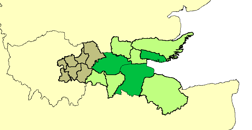
Thames Gateway is a term applied to an area around the Thames Estuary in the context of discourse around regeneration and further urbanisation. The term was first coined by the UK government and applies to an area of land stretching 70 kilometres (43 mi) east from inner east and south-east London on both sides of the River Thames and the Thames Estuary. It stretches from Westferry in Tower Hamlets to the Isle of Sheppey/Southend-on-Sea and extends across three ceremonial counties.
Rationale
[edit]The area was designated during the early years of the Blair ministry as a national priority for urban regeneration because it contained large amounts of brownfield land and to take advantage of rail capacity improvements created at Stratford and in parts of Kent, by the High Speed 1 railway (officially known as the Channel Tunnel Rail Link). The term was first coined by the UK government, with the government and others also use the term Thames Estuary to apply to the area.[1][2] Much of the brownfield land has now been redeveloped.
Scope
[edit]The Thames Gateway has a population of over 3 million[3] and comprises generally Thameside belts of 16 local government districts:
| County | Districts |
|---|---|
| London | From the North East and South East London sub-region, the London boroughs of Barking and Dagenham, Bexley, Greenwich, Havering, Lewisham, Newham and Tower Hamlets. These have non-planning powers similar to unitary authorities, however are influenced in planning by the Mayor of London and London Assembly. |
| Essex | Planning authorities (influenced only by Essex County Council) (that is, non-metropolitan districts): Basildon, Castle Point and Rochford; and the (planning and) unitary authorities of Thurrock and Southend-on-Sea |
| Kent | Planning authorities (influenced only by Kent County Council) (that is, non-metropolitan districts): Dartford, Gravesham and western parts of Swale; and the (planning and) unitary authority of Medway |
Profile
[edit]The immediate settlements next to the types of land indicated, not taking the authorities as a whole, contains about half of the population of those authorities: 1.6 million people and contained in the 2000 survey some of the most deprived wards in the country, characterised by lack of access to public transport, services, employment and affordable quality housing, in particular having many overspill estates from earlier slum clearance and London's urban planning – examples being from Thamesmead to Southend-on-Sea.[4]
Its boundary was drawn to capture the riverside strip that formerly hosted many land-occupying industries, serving London and the South East, whose decline has left a patchy legacy of dereliction and contaminated land. Striking precursor examples of development are those pioneered at Canary Wharf and on the Greenwich Peninsula, which the governments since 2000 have aimed to reflect across this area (having widespread comparable land use to those tracts of land).[4]
Its brownfield land, farmland and wild salt marshland has been seen by successive governments and planners as having potential to act as a catalyst for the regeneration and growth and for the social advancement of the area, helping to alleviate some of the growth pressures on London and the South East. Amid steep house price inflation and an economic boom in 2004 the government also expressed the firm belief that new private sector housing here and elsewhere would reduce that inflation.[5]
Parts of the area are of settled character and/or already densely populated with little scope for housing developments: Southend-on-Sea, for example, is the eighth most densely populated district in the country outside London and mass expansion is not desired owing to the river at the south, the need for leisure space and animal habitat (mostly in the buffer zones separating communities) and an economic desire and legal demand to preserve the existing character of housing estates.
Administration and delivery
[edit]The Department for Communities and Local Government is responsible for co-ordinating the project.
The Thames Gateway project aims to improve the economy of the region through the development of marshland, farmland and brownfield land, through major transport infrastructure provision and the renaissance of existing urban conurbations.[6]
Comparisons may be drawn with developments east of Paris along the Marne valley, which applied to a significantly smaller volume of land.
Formerly the development was in part delivered by the three regional development agencies: the London Development Agency (LDA – part of the Greater London Authority), the East of England Development Agency (EEDA) and the South East England Development Agency (SEEDA), as well as the national regeneration agency, English Partnerships.
Development that is supplemental to councils' own development plans is delivered through Local Authorities (Councils), special purpose development corporations and local enterprise partnerships, all of which are eligible for grants from government departments funded by HM Treasury. Additional government funds were supplied to the Regional Development Agencies who supported some projects in the Gateway.
Former redevelopment zones
[edit]Formerly, the development was split into zones each with a different agency responsible for delivery. The zones were:
| Region | Zones | Former delivery agencies |
|---|---|---|
| London |
|
London Thames Gateway Development Corporation |
|
Greenwich Partnership and Bexley Partnership | |
| South East |
|
Kent Thameside Delivery Board, Medway Renaissance Partnership, Swale Forward |
| East | Thurrock Thames Gateway Development Corporation, Basildon Renaissance Partnership and Renaissance Southend |
Developments
[edit]Before 2003 most conspicuous development was situated west of Beckton. There have been substantial housing schemes at Chafford Hundred, Chatham and Greenhithe and there is a large shopping centre at Bluewater.
| Region | Project | Description | Status |
|---|---|---|---|
| London, East, South East | High Speed 1 | High speed rail line linking Stratford and Ebbsfleet stations in the Gateway area to central London and continental Europe. | Fully operational. |
| London | Thames Gateway Bridge | Road bridge between Beckton and Thamesmead near to the existing Woolwich Ferry. Designed to provide segregated bus, tram or DLR carriage.[citation needed] | Cancelled[7] |
| London | Stratford City | 73 hectares (180 acres) mixed use site of 200 shops, three large department stores, cafés, schools, hotels, parks and health centres. 11,000 residents and 30,000 workers. Part of the site was used for the London 2012 Olympics.[citation needed] | Completed. |
| London | East London Transit | The East London Transit is an intermodal transport scheme to connect housing developments to rail and tube. | Phase I opened Feb 2010. |
| London | White Hart Triangle | Mainly derelict land close to Plumstead railway station that was developed with the aim of creating 2000 new jobs, with funding from the London Development Agency and European Union. | Completed |
| East | London Gateway | Port with logistics and a business park. The port was developed at Shell Haven, a 607 hectares (1,500 acres) site in Thurrock.[4] The two schemes were originally expected to create up to 16,500 new jobs.[8] | Completed |
| East | Southend-on-Sea | The council is using money provided through the scheme to redevelop the town centre and seafront and create a "transport corridor" along the A13.[citation needed] | |
| East | Basildon District | £2 billion major developments planned. These include the regeneration of Basildon, Wickford, Pitsea and Laindon town centres; a new sporting village, a health and education research centre, investment in the Basildon Enterprise Corridor business area, a wetland nature reserves in the Thames Marshes and investment in housing estates such as Craylands, Five Links and Felmores. | |
| South East | Ebbsfleet Valley | Ebbsfleet Valley was constructed in the area around Ebbsfleet International station. It consists of over 790,000 square metres (8,500,000 sq ft) of mixed-use development, including housing, retail, residential, hotel and leisure sites. | |
| South East | Swanscombe Peninsula | Previously the location of the Swanscombe Cement Works, this 130-hectare (1.3-square-kilometre; 0.50-square-mile) site, partly in both Dartford and Gravesham, is planned to have 2,700 homes and 500,000 sq ft (50,000 m2) of office space.[citation needed] | |
| South East | The Bridge | Lying close to the Queen Elizabeth II Bridge on and around the site of the former Joyce Green Hospital, this 107-hectare (1.07-square-kilometre; 0.41-square-mile) development will have 1.5 million square feet (140,000 m2) of business space and 1500 residences.[citation needed] | |
| South East | Dartford Northern Gateway | In early 2006 SEEDA (The South East England Development Agency) purchased a 2.6-hectare site on the edge of Dartford which had been used by Unwins, an off-license chain, which went into administration in 2005. They also purchased the neighbouring Matrix Business Centre to protect its future. They intend to develop the site with a mixture of retail and other businesses and housing.[citation needed] It is also the home to The Orchestra of the Thames Gateway, an organisation that has given more than 230 performances in the Gateway area up until the end of 2009. | |
| South East | Stone Castle | It is located to the north of Bluewater Shopping Centre and will be a mix of residences, a new publicly accessible linear park in St Clement's Valley and a high quality business park set back from St Clement's Way.[citation needed] Phase 1 is known as Waterstone Park, where about 200 of an eventual 650 residences have been built. | |
| South East | Northfleet Embankment | An industrial site of 74 hectares (0.74 km2) with 1.9 km of river frontage. Key sites have been acquired by SEEDA to prepare for the re-development of the area, which could potentially begin once the Northfleet Cement Works moves to the Medway Valley in 2008.[citation needed] | |
| South East | Chatham Town Centre & Waterfront | Projected to deliver 1500 new homes, plus a variety of other projects, including the Dickens World tourist attraction (opened May 2007, closed 2016); the Great Lines City Park; refurbishment and expansion of the Pentagon shopping centre with 1,4000 square metres of new stores and leisure facilities; a new 'cultural quarter' centred on Medway REACH, a new 2000 seat auditorium. Funding is being sought for a cable car system across the River Medway.[citation needed] | |
| South East | Gillingham Waterfront[9] | 1000 new residences and 200 new jobs were projected to be created on this 32-hectare site by 2010. This site includes the Peel Group "Chatham Waters" site and the Berkeley Homes "Victory Pier" housing development. | |
| South East | Rochester Riverside | Key sites have been acquired by Medway Council and other areas are being acquired SEEDA to prepare for the re-development of the area, with 30 hectares being cleared and decontaminated. Proposed plans include 1700 new residences. Planning permission was granted in late 2017.[10] 2.5 kilometres of new river wall have been constructed, with the site also being raised by 2 metres.[citation needed] | |
| South East | Strood Riverside | About 500 new homes, improved waterfront access and improved flood defences. This site has not yet started construction. | |
| South East | Temple Waterfront | A 21-hectare site with a possible 600 new homes and part of the waterfront designated for nature conservation. According to Medway Renaissance, the potential for a new railway station is being investigated.[citation needed] |
Environmental implications
[edit]Proposals for a large international airport on Cliffe Marshes were dropped from the government's white paper on air transport in 2003 after they were rejected by local residents, the local council, as well as conservation charities such as the RSPB. The plan, which would have required the raising the ground level by 15 m.[11] was also rejected by the Confederation of British Industry as too expensive.[12]
On the question of airport capacity, the Government had established the independent Airports Commission, headed until 2015 by Sir Howard Davies. The Commission examined the nature, scale and timing of any requirement for additional capacity to maintain the UK's global hub status. The Aviation Policy Framework of March 2013 was an important piece in the jigsaw, setting out the principles which the commission would take into account in presenting its recommendations reported in 2013 and in 2015.[13] The options included an outside possibility of a floating airport off the Isle of Sheppey.[14]
Historically the north of Kent has always been marshland but has been coming under great pressure by developers. A public inquiry found in favour of a rail freight depot proposed by ProLogis at Howbury in Slade Green.[15] The proposal was to develop part of the Metropolitan Green Belt in the Crayford Marshes beside the existing railway depot. Roxhill Developments Ltd.[16] had sought to modify the planned 149 acre "sustainable distribution park with modern multi modal connections" since at least 2015.[17]
The London Development Agency perceived some strategic merit in the proposals,[citation needed] but local councillors were not convinced that such a depot would truly encourage train movements as an alternative to road haulage.[citation needed] This scepticism arose partly because the railways in the area are heavily used by scheduled passenger trains, to the extent that the projected Crossrail programme seemed unlikely to progress to Dartford unless new tracks were laid to boost local rail capacity.[citation needed] The ProLogis appeal was upheld by a 2007 Public Inquiry on the basis that the proposal supported the Energy policy of the United Kingdom and generated new jobs. Counter-arguments included that eventual warehouse occupiers would not use the site in the manner suggested, that continuous noise levels would exceed WHO Community Noise Guidelines at homes in Moat Lane and that night-time noise levels risked generating complaints from residents at Moat Lane and Oak Road.[15]
The Environment Agency advised that future development in the "Thames Gateway" must go hand-in-hand with flood risk management, and take account of future plans for flood protection. The Agency insisted it was important that effective flood risk management of the whole Estuary be not prejudiced by premature decisions and developments.[18]
The Government addressed some of these environmental concerns by designating the Thames Gateway as the UK's "eco-region", first announced in the 2007 Thames Gateway Delivery Plan.[19] The objective of the "eco-region" was to protect and enhance the sustainability of the "Thames Gateway" in terms of environmental quality, carbon reduction, and support for "green" economic development. This vision was elaborated in the 2008 Thames Gateway "eco-region prospectus",[20] and implementation efforts were led by the Homes and Communities Agency with support across government and [unspecified] local stakeholders.
Cultural references
[edit]The liminal and sometimes bleak settings of the Thames Gateway have inspired several cultural works.
- Nicola Barker has written a loose trilogy of novels termed Thames Gateway.
- Iain Sinclair's novel Dining on Stones follows the A13 from London to Essex.
- Graham Swift's novel Last Orders involves a journey down the A2/M2 corridor from London to Margate.
References
[edit]- ^ Geoff Vigar (2002). The Politics of Mobility: Transport Planning, the Environment and Public Policy. Taylor & Francis. ISBN 0415259169.
- ^ "Thames Estuary 2050 Growth Commission report". GOV.UK. 25 March 2019. Retrieved 24 August 2023.
- ^ "[ARCHIVED CONTENT] UK Government Web Archive – The National Archives".
- ^ a b c "General Description". London Gateway. Retrieved 2 March 2013.
{{cite web}}: CS1 maint: deprecated archival service (link) - ^ "Kate Barker's Review of Housing supply: Final Report published". HM Treasury. 17 March 2004. Archived from the original on 10 September 2008. Retrieved 2 March 2013.
- ^ "Thames Gateway: explained". BBC. Retrieved 2 September 2022.
- ^ "Mayor outlines ten-year plan for massive transport expansion". Mayor of London. Archived from the original on 24 March 2009. Retrieved 10 November 2008.
- ^ "The Business Centre". London Gateway. Retrieved 2 March 2013.
{{cite web}}: CS1 maint: deprecated archival service (link) - ^ "Regeneration | Medway Council". Medway.gov.uk. Retrieved 7 December 2018.
- ^ "£400 million plan at Rochester Riverside given green light". Kentonline.co.uk. 27 October 2017. Retrieved 7 December 2018.
- ^ Aviation document 026038 of 2003. Department for Transport Archived 13 October 2009 at the Wayback Machine
- ^ Andrew Clark (16 December 2002). "Thumbs down to Kent airport". The Guardian. Retrieved 2 March 2013.
- ^ Aviation Policy Framework: Command Paper 8584 presented to Parliament (by the Department for Transport) March 2013. Retrieved 30 August 2013
- ^ "New airport threat for north Kent". BBC News. 16 June 2004. Retrieved 2 March 2013.
- ^ a b Phillipson, Andrew. "Report to the Secretary of State for Communities and Local Government" (PDF). The Planning Inspectorate. Archived from the original (PDF) on 17 September 2016. Retrieved 8 September 2016.
- ^ "Home". Roxhill.
- ^ "Howbury Park, Bexley – Planning Application in Progress". Roxhill. Retrieved 8 September 2016.
- ^ "More than Mudflats and Microflats – the Thames Gateway landscape". Audacity.org. Archived from the original on 21 January 2013. Retrieved 2 March 2013.
- ^ "The Thames Gateway Delivery Plan". Communities and Local Government. 29 November 2007. Archived from the original on 22 February 2010. Retrieved 2 March 2013.
- ^ "The Thames Gateway Eco-Region: A Prospectus" (PDF). Communities and Local Government. November 2008. Archived from the original (PDF) on 10 June 2015. Retrieved 2 March 2013.
External links
[edit]- Clark, Andrew (16 December 2002). Thumbs down to Kent airport. The Guardian (UK national title)
- Thames Gateway London Partnership
- Wildlife Gateway – Providing a resource for information on development with wildlife in mind
- Thames Gateway South Essex Partnership Archived 4 February 2007 at the Wayback Machine
- Thames Gateway Kent Partnership
- Greengrid – Connecting green spaces in South Essex
- Thames Gateway Forum
- Medway Renaissance
- Invest Thames Gateway website
- 'KenEx' Thames Gateway Tramlink Ltd – Providing sustainable public transport within the Thames Gateway Development Area
| Companies | |||||||||
|---|---|---|---|---|---|---|---|---|---|
| Currency, governance, regulation | |||||||||
| History | |||||||||
| Nations, regions, cities |
| ||||||||
| People and labour | |||||||||
| Sectors |
| ||||||||
| Trade and business organisations | |||||||||


Thames Gateway
View on GrokipediaDefinition and Scope
Geographical Boundaries
The Thames Gateway delineates a regeneration zone along the River Thames estuary, extending approximately 40 miles (64 km) eastward from Canary Wharf in East London to Sheerness on the Isle of Sheppey in Kent and Southend-on-Sea in Essex.[1] This corridor encompasses land on both north and south banks of the estuary, covering a total area of around 450 square kilometers.[5] The boundaries are defined by the Thames waterway as the central axis, with the zone broadening to include adjacent urban, industrial, and rural lands suitable for development.[6] In Greater London, the area begins at the eastern fringes, incorporating the Lower Lea Valley and riverside districts in the boroughs of Tower Hamlets, Newham, Greenwich, Bexley, and parts of Hackney, Waltham Forest, and Lewisham.[7] Progressing downstream, it traverses the county of Kent, encompassing the unitary authorities and districts of Dartford, Gravesham, Medway, and Swale, up to the outer estuary limits near Sheerness.[8] On the northern Essex shoreline, the zone includes Thurrock, Basildon, Castle Point, Rochford, and Southend-on-Sea, terminating at the coastal boundary where the Thames meets the North Sea.[9] These boundaries were formally outlined in UK government planning documents during the late 1990s and early 2000s as part of the national regeneration strategy, prioritizing brownfield sites and transport corridors while excluding more distant inland areas.[10] The precise delineations vary slightly across sub-zones managed by development corporations, such as the London Thames Gateway Development Corporation for inner areas and Thurrock Thames Gateway Corporation for Essex portions, but collectively form a cohesive estuarine band focused on sustainable urban expansion.[7]Core Objectives and Vision
The Thames Gateway initiative, designated as Europe's largest regeneration project in 2003 under the UK Labour government, envisioned transforming a 40-mile stretch of post-industrial land along the Thames Estuary into a model of sustainable urban growth. The core vision emphasized creating vibrant, economically dynamic communities that leverage the area's strategic location for investment, employment, and high-quality living, while preserving natural landscapes, enhancing built environments, and honoring historical heritage.[2][1] Key objectives centered on economic revitalization, targeting the creation of 225,000 new jobs by 2016 through developments in priority zones such as Canary Wharf extensions, London Gateway port, Ebbsfleet Valley, and Stratford City/Olympic Park. This was supported by over £9 billion in cross-government funding, including £500 million for direct regeneration and a £200 million Strategic Economic Investment Fund to attract private leverage. Housing goals aimed to deliver 160,000 new homes by 2016, with at least 110,000 in ten designated growth areas, prioritizing 80% brownfield sites and £800 million allocated for 15,000 affordable units to foster mixed-tenure sustainable communities.[2][1] Broader aims included improving accessibility via transport infrastructure upgrades, skills development with £1.6 billion for training and £850 million for educational facilities creating 9,000 places, and £1.4 billion for health and school enhancements to elevate quality of life. Environmental integration sought to protect biodiversity and flood defenses, aligning development with ecological realism rather than unchecked expansion, though policy documents noted challenges in translating high-level aspirations into enforceable local targets.[2][1]Historical Context
Pre-20th Century Foundations
The Thames Estuary, forming the core of the Thames Gateway region, has served as a natural corridor for human migration, trade, and resource exploitation since prehistoric times, owing to its sheltered waters, fertile gravel terraces, and adjacent marshes suitable for grazing, fishing, and salt production. Archaeological evidence reveals continuous occupation from the Palaeolithic era, with the Swanscombe skull—dated to approximately 400,000 years ago—representing one of the earliest hominid remains in Britain, found in gravel deposits near the river. Mesolithic hunter-gatherer activity (c. 8,000–4,500 BC) is attested by stone tools and debris at sites like Crayford and Erith, while Neolithic farming communities (c. 4,500–2,300 BC) established causewayed enclosures at Orsett in Essex and Kingsborough Farm on the Isle of Sheppey, indicating organized land use and ceremonial practices amid rising sea levels that expanded marshlands.[11] Bronze Age developments (c. 2,300–700 BC) included barrows, field systems at South Hornchurch and the Isle of Sheppey, and wooden trackways crossing wetlands, alongside metal hoards suggesting emerging trade networks along the estuary. Iron Age settlements (c. 700 BC–43 AD) featured proto-urban oppida potentially linked to Rochester's origins, farmsteads on the Hoo Peninsula and Isle of Grain, and transhumance patterns reflected in extensive field systems, with the river facilitating coracle-based navigation and continental influences evident in isotopic analysis of remains at sites like Blackwall. The estuary's tidal dynamics and gravel resources supported these activities, though environmental shifts, including sea-level rise, periodically submerged forests and settlements.[11][12] Roman occupation from 43 AD onward intensified the region's role as a gateway, with settlements along the London-Dover road (A2, possibly Iron Age in origin) at Rochester and Crayford, rural villas in the Darenth and Medway valleys, and industrial sites for salt and pottery production in Upchurch marshes. In South Essex, dispersed farms coexisted with Canvey Island's "red hills"—mounds of fired clay residue from saltworking—and fish-processing operations, underscoring the marshes' economic value. Saxon and medieval periods (c. 5th–15th centuries) saw trading centres at Lundenwic and Canvey, minster churches like Minster on Sheppey, and Viking incursions using bases at Shoebury and Sheppey, evidenced by the Graveney boat remains; marsh reclamation began around the 8th century, enabling open-field systems of Dengie form and sustained saltworking, as seen in 13th-century mounds at Graveney. By the 19th century, agricultural processing mills and early industrial sites, such as Erith's oil works precursors, built on these foundations, while designed landscapes like Greenwich (established 17th century but expanded) highlighted the area's integration into London's orbit.[11]20th Century Industrial Decline
The Thames Gateway's industrial economy, centered on the Port of London, shipbuilding, and ancillary manufacturing in east London, Essex, and Kent, peaked in the early post-World War II decades before entering a protracted decline from the mid-1960s. Traditional docks struggled with the shift to containerization, which demanded deeper waters, larger quay lengths, and mechanized handling incompatible with the Thames's tidal constraints and upriver bridges, diverting traffic to coastal ports like Felixstowe and Southampton.[13] Trade volumes through the Port of London fell sharply, with coal imports—once a staple—disappearing after the 1960s due to the closure of gas works and shift to alternative energy sources.[14] Progressive dock closures accelerated job losses and urban decay. Upstream facilities shuttered between 1967 and 1980, including the Surrey Commercial Docks and London Docks in 1969, followed by the West India and Millwall Docks in the late 1970s; the Royal Docks, the last major enclave, ceased commercial operations on December 7, 1981, after handling declining cargoes in Victoria, Albert, and King George V basins.[15] [16] [17] Tilbury Docks, located further downstream in Essex and better suited for some modern vessels, persisted but experienced volume reductions amid competition from European hubs like Rotterdam.[18] These closures left vast brownfield expanses derelict by 1981, with associated warehousing, engineering, and processing industries collapsing, contributing to London's overall manufacturing workforce dropping from over 1.5 million in 1960 to a fraction by century's end.[19] [20] Shipbuilding and repair yards along the estuary fared no better, reflecting broader UK sector contraction. Early 20th-century closures like Thames Ironworks in 1912 presaged later losses, but post-1940s deindustrialization hit repair facilities in the Thames Estuary hard, with low-skill processing and Fordist assembly lines succumbing to global outsourcing and automation.[21] In Kent, the Royal Navy's Chatham Dockyard—operational for over 400 years—closed on March 31, 1984, eliminating thousands of skilled jobs in shipbuilding, maintenance, and support services, which reverberated through the Medway Towns' economy, fostering persistent social and infrastructural challenges.[22] [23] [24] This era of decline transformed the Gateway into a landscape of underutilized industrial land, high unemployment, and economic stagnation, setting the stage for later regeneration efforts amid national deindustrialization trends driven by trade liberalization and sectoral shifts away from import-dependent heavy industry.[25] [18]Initiation Under New Labour (1990s–2000s)
Following the 1997 general election, the New Labour government under Prime Minister Tony Blair prioritized the Thames Gateway as a flagship urban regeneration project, building on earlier planning frameworks to address brownfield land redevelopment in eastern Greater London, Essex, and Kent.[26] The initiative aimed to transform derelict industrial sites into sustainable communities, emphasizing high-density housing, improved transport links, and economic revitalization to accommodate London's eastward expansion.[3] In 2000, the government established the Thames Gateway Strategic Partnership, a cross-sector body involving local authorities, regional development agencies, and national departments to coordinate planning and investment across the 40,000-hectare area.[3] This was followed in 2001 by the designation of the Thames Gateway as one of four national Growth Areas under the Sustainable Communities Plan, with the creation of the Thames Gateway Growth Area Fund to accelerate housing delivery and infrastructure.[26] The Department for Transport committed £1.8 billion to enhancements such as rail capacity and road improvements starting that year.[2] Housing targets were set at 160,000 new homes by 2016, primarily on brownfield sites, with an associated goal of 180,000 jobs to support population growth estimated at 22% in core areas by mid-decade.[3] To drive implementation, development corporations were formed in 2004, including the London Thames Gateway Development Corporation and Thurrock Thames Gateway Development Corporation, empowered to assemble land and enforce compulsory purchases where necessary.[26] These entities received initial public funding of around £10 million annually for local partnerships, though the bulk of the projected £35 billion in capital was anticipated from private investors.[3] By 2003, the Sustainable Communities Plan allocated £846 million in seed funding, enabling early site preparations in locations like Stratford and Ebbsfleet.[3] In April 2005, Blair and Deputy Prime Minister John Prescott formally launched a £6 billion action plan in Gravesend, underscoring commitments to flood defenses, green spaces, and mixed-use developments to mitigate environmental risks in the flood-prone estuary zone.[27] This phase marked the project's shift from conceptual planning to active delivery, with annual strategy reviews through 2007 refining coordination amid challenges like infrastructure sequencing.[26]Governance and Implementation
Establishment of Development Corporations
The Thames Gateway regeneration initiative, launched by the UK government in 2003 as part of the Sustainable Communities Plan, relied on urban development corporations (UDCs) to coordinate large-scale development in underutilized post-industrial lands along the Thames estuary. These entities were created under the Local Government, Planning and Land Act 1980 (sections 134–135 and Schedule 26), empowering the Secretary of State to designate urban development areas and establish corporations with statutory powers including compulsory purchase of land, granting planning permissions, and assembling sites for housing, commercial, and infrastructure projects. The UDCs aimed to overcome local authority constraints and accelerate private investment, targeting the creation of up to 160,000 homes and 180,000 jobs across the Gateway by 2016.[28] The first such corporation, Thurrock Thames Gateway Development Corporation, was established on 29 October 2003 via the Thurrock Development Corporation (Area and Constitution) Order 2003 (SI 2003/2896), covering the entire Borough of Thurrock in Essex, an area of approximately 64 square miles with significant docklands and brownfield sites.[28] Its mandate focused on economic regeneration through port expansions, logistics hubs, and residential development, with planning functions transferred to it in October 2005 to streamline approvals.[29] In 2004, two additional corporations were formed to address London and Kent segments. The London Thames Gateway Development Corporation came into existence on 26 June 2004 under the London Thames Gateway Development Corporation (Area and Constitution) Order 2004 (SI 2004/1642), designating two zones: the 1,400-hectare Lower Lea Valley (including sites later used for the 2012 Olympics) and the 870-hectare London Riverside area east of the City.[30] [31] This body was tasked with delivering 40,000 homes and related infrastructure, leveraging compulsory purchase orders for over 200 sites.[32] The Kent Thameside Development Corporation was similarly established in July 2004, targeting 22 square miles across Dartford and Gravesham boroughs north of the A2 corridor, including Ebbsfleet and Swanscombe.[2] It prioritized high-speed rail integration via Ebbsfleet International station and mixed-use developments to attract 35,000 residents and 30,000 jobs, with powers to override local plans where necessary for Gateway-wide objectives.[2] These corporations operated as mayoral development corporations precursors, with boards comprising government appointees, local leaders, and private sector experts to ensure cross-boundary coordination.[29]Policy Shifts Post-2010
Following the formation of the Conservative-Liberal Democrat coalition government in May 2010, Thames Gateway policy underwent significant restructuring amid broader efforts to reduce public spending and eliminate non-departmental public bodies (quangos). The coalition's Public Bodies Bill and associated reviews targeted entities like the London Thames Gateway Development Corporation (LTGDC) and Thurrock Thames Gateway Development Corporation (TTGDC), established under the previous Labour administration to drive centralized regeneration. These reforms emphasized localism, devolving powers to local authorities to replace top-down intervention, as articulated in the coalition's programme for government and the 2010 quango efficiency review.[33][34] The LTGDC, responsible for coordinating development in east London areas such as the Lower Lea Valley and Stratford, was wound down starting in 2011, with its dissolution formalized on 28 February 2013 via the London Thames Gateway Development Corporation (Dissolution) Order. Assets, property rights, and liabilities—valued at over £100 million in land holdings—were transferred to the Greater London Authority (GLA) under the London Thames Gateway Development Corporation (Transfer of Property, Rights and Liabilities) (Greater London Authority) Order 2012, enabling local oversight rather than national directive. Similarly, the TTGDC, focused on Essex sites including Tilbury and Purfleet, ceased operations on 31 October 2012, with responsibilities reverting to Thurrock Council and regional partners to align with fiscal austerity measures that cut £500 million from quango budgets.[35][36] This decentralization reflected a policy pivot from Labour's growth corridor model, which had committed £9 billion in public funds by 2010, to a leaner framework prioritizing private investment and local enterprise zones. The Thames Gateway Strategic Group, established on 25 November 2010 under the Minister for the Thames Gateway, was tasked with cross-regional coordination without statutory powers, signaling reduced central impetus. Critics, including regeneration experts, noted that these changes contributed to stalled momentum, with housing delivery falling short of pre-2010 targets (e.g., only 40,000 of 160,000 planned homes completed by 2015), attributed to funding cuts and fragmented governance.[26][37]Private Sector Involvement
The Thames Gateway regeneration initiative has relied extensively on private sector financing and expertise to deliver housing, infrastructure, and commercial developments, with public investments designed to leverage substantially larger private contributions. According to a 2007 National Audit Office report, the majority of funding for housing and other infrastructure was anticipated to come from private sources, supplemented by approximately £7 billion in government capital and revenue spending since 2003.[2][2] In practice, mechanisms such as the London Thames Gateway Development Corporation (LTGDC) facilitated private investment, projecting outcomes like £228 million in private funds yielding 1,100 new homes and 870 jobs in the 2010/11 fiscal year alone.[38] Public-private partnerships have been central to implementation, with development corporations and local authorities collaborating with developers to remediate land and unlock sites. For instance, the LTGDC shortlisted eight major projects in areas like the Lower Lea Valley and London Riverside in 2006, securing commitments for £4 billion in private-sector cash to advance regeneration.[39] Boards overseeing progress, such as those under the Thames Gateway London Partnership, incorporated private developers to align efforts on housing and economic targets.[40] In Kent and Essex, initiatives like the Thames Gateway Kent Partnership emphasized creating conditions for private-led economic growth, including attracting investors for sustainable projects.[41] Specific leverage examples illustrate the model's scale: a £30.5 million Regional Growth Fund bid in Kent aimed to catalyze over £400 million in private investment over a decade through the TIGER program.[42] Similarly, in South Essex, £5.5 million in local growth funding matched public contributions to unlock an equivalent private amount for infrastructure.[43] Broader pipelines, as tracked by the Thames Estuary Partnership, have identified over £49 billion in potential investment projects involving private entities across the region.[44] Recent efforts, such as the Thames Freeport, have drawn £4.5 billion in combined public-private investment, including private deployments like multisite 5G networks to support logistics and job creation.[45][46] Private developers have driven key sites, including expansions at Greenwich Peninsula and opportunities tied to Canary Wharf's eastward growth, where competitions solicited international firms for design and delivery.[47][48] Despite these engagements, outcomes have varied, with public funding often needed to de-risk sites amid economic shifts post-2010, though private sector delivery remains the projected primary engine for the initiative's 160,000+ housing and economic goals.[2]Key Developments and Infrastructure
Housing Projects
The Thames Gateway housing strategy targeted the construction of 160,000 new homes across the region by 2016, with the London portion encompassing zones of change capable of accommodating up to 90,000 dwellings based on capacity studies by the London Development Agency.[49] The London Thames Gateway Development Corporation (LTGDC), established in 2004, played a central role in unlocking sites through planning consents and infrastructure investments, granting 190 consents in 2010/11 alone for 4,196 homes alongside cumulative approvals for 17,896 residential units, of which 4,048 were affordable.[38] Delivery lagged behind ambitions, hampered by the 2008 financial crisis, reduced public funding post-2010, and market weaknesses that stalled developments and eroded property values.[38] Prominent projects included Barking Riverside in the London Borough of Barking and Dagenham, a flagship brownfield redevelopment on a former power station site initially planned for 10,800 homes, with LTGDC investing £8.5 million to initiate 300 starts in October 2010 and directly commencing 64 family homes (half affordable) in 2011 for completion by summer 2012.[38][7] The scheme has since expanded, with approvals in September 2025 for an additional 651 homes in a subsequent phase, set to begin construction in 2026 and deliver affordable units by 2028, contributing to a revised masterplan for up to 20,000 homes overall.[50] In Canning Town, LTGDC facilitated a £600 million mixed-use scheme including 1,100 homes, with 270 starts at Rathbone Market in December 2010 as part of over 650 planned units integrated with retail and transport improvements.[38] Other initiatives encompassed the Sugar House Lane site in Stratford, acquired by LTGDC in September 2010 with potential for 1,500 homes, and Bromley by Bow, where 454 homes were planned in June 2010 alongside district centre enhancements.[38] In South Essex sub-regions, strategies emphasized 35% affordable housing provision to align with sub-regional targets, though economic downturns curtailed starts and completions.[51] Post-LTGDC dissolution in 2012, responsibilities devolved to local authorities and the Greater London Authority, shifting focus to private-led delivery amid persistent shortfalls, with design quality reviews of 41 schemes in 2007/08 highlighting variable standards in density and urban integration.[7][52]Transport Enhancements
The Elizabeth Line, operational from November 2022, has boosted rail capacity in the Thames Gateway via its eastern branches terminating at Abbey Wood in southeast London and Shenfield in Essex, enabling faster journeys to central London and supporting urban regeneration by accommodating projected passenger growth of up to 1.5 million additional daily trips across the network.[53][54] Extensions beyond Abbey Wood to Ebbsfleet or Gravesend, including potential stations at Erith, have been proposed to further integrate Kent's Thames Gateway areas, aligning with regeneration goals to enhance access to employment hubs.[55] Road infrastructure enhancements include the Lower Thames Crossing, a 23 km route featuring a 4.2 km twin-bore tunnel under the Thames between Thurrock in Essex and Gravesend in Kent, designed to provide an alternative to the congested Dartford Crossing and handle up to 90,000 vehicles daily. Development consent was granted in March 2025, with enabling works, including soil treatment at the northern portal, set to begin in late 2025 and full construction following thereafter, at an estimated cost exceeding £10 billion.[56][57] Additional public transport proposals encompass a Docklands Light Railway extension from Gallions Reach across the Thames to new stations at Beckton Riverside and Thamesmead, aimed at improving east London connectivity within the Gateway.[58] Light rail ambitions, such as the Thames Gateway Tramlink involving a tunnel under the river to link south Essex and north Kent, remain under consideration to foster cross-estuary integration, though implementation timelines extend potentially a decade or more.[59] Local improvements in Thames Gateway South Essex emphasize enhanced bus priority, walking, and cycling networks to complement major schemes, funded through local transport plans and developer contributions.[60]Port and Commercial Expansions
The Thames Gateway regeneration initiative has emphasized port infrastructure as a cornerstone for economic revival, leveraging the estuary's strategic location to handle increased container traffic and support logistics growth. Major expansions target deep-water capabilities to accommodate ultra-large vessels, addressing capacity constraints at upstream ports like Felixstowe. These developments integrate with adjacent commercial facilities, including logistics parks and rail connections, to facilitate multimodal freight distribution.[61][62] London Gateway Port, situated on the former Shell Haven oil refinery site in Thurrock, represents the flagship project, with initial construction commencing in February 2010 under DP World (formerly P&O Ports). The £1.5 billion facility opened its first three berths progressively from 2013, achieving a current annual capacity of 2.4 million TEUs across 17-meter-deep berths. In March 2025, DP World announced a £1 billion expansion, including two additional 400-meter all-electric berths and a second rail terminal, set to increase capacity by 50% and position it as the UK's largest container port upon completion in approximately four years. This phase, part of the Thames Freeport consortium, is projected to generate over 1,000 construction jobs and 400 permanent roles, enhancing supply chain efficiency for UK imports.[63][64][65] Adjacent commercial expansions at London Gateway encompass a 728-hectare logistics park, Europe's largest, featuring automated terminals and business spaces to support port operations. The park integrates rail and road links, enabling direct goods transfer to inland markets while minimizing road congestion.[66] The Port of Tilbury, further upstream in Thurrock, has undergone phased expansions to complement London Gateway, including the completed Tilbury2 project, which added multipurpose berths for aggregates and containers. In May 2025, Forth Ports submitted plans for Tilbury3, a 100-acre extension creating new quay facilities and unlocking Freeport tax incentives through collaboration with DP World. If approved, construction could start in 2026, with operations by 2030, bolstering regional freight handling amid rising Thames estuary trade volumes.[67][68][69] These port initiatives, framed within Thames Freeport policies, aim to capture post-Brexit trade flows and energy transition opportunities, though realization depends on navigational dredging and environmental consents.[62][45]Economic Outcomes
Job Creation and Growth Metrics
The Thames Gateway regeneration programme set a target of 180,000 new jobs across the area by 2016, later revised upward to 225,000 in some projections. [2] [70] Early progress included approximately 34,000 additional jobs created in East London and the Thames Estuary by 2007, aligning with initial trajectories toward the target. [26] Actual employment outcomes fell short of ambitions, with growth rates in the broader Thames Estuary averaging 19% from 2009 to 2016, compared to 21% across London overall and 27% in East London specifically. [71] Assessments post-2010 highlighted painfully slow employment expansion relative to housing development and national benchmarks, attributed in part to uneven spatial distribution and challenges in attracting high-value investment. [72] Subregional variations showed modest gains, such as targets for 55,000 additional jobs in Thames Gateway South Essex by around 2021, but delivery remained constrained by infrastructure delays and market conditions. [73] Overall, while some commercial floorspace developments supported localized job uptake—e.g., projections for 24,000 jobs in specific Kent sites by the mid-2010s—systemic underperformance against core metrics underscored limited net economic multiplier effects from the initiative. [1]Fiscal Costs and Returns
The Thames Gateway regeneration initiative involved substantial public sector funding, with the UK government committing over £9 billion in investments between 2003 and 2011 to support infrastructure, housing, and economic development across the region.[74] This included annual grants-in-aid to development corporations, such as £33.95 million provided to the London Thames Gateway Development Corporation in 2010-11, enabling £35.2 million in total investments that year.[38] Additional commitments came from regional agencies, with the London Development Agency allocating £300 million over five years for economic and social regeneration.[75] Funding sources encompassed central government departments, primarily the Department for Communities and Local Government, alongside contributions from local authorities and European funds, though the bulk derived from national taxpayers.[76] Projections anticipated significant economic returns, with the East of England Development Agency estimating that full realization of growth ambitions could add £12 billion to regional gross value added through job creation and business expansion.[77] Private sector leverage was expected to match public inputs approximately 1:1, amplifying total development value to around £38 billion by 2016, primarily via commercial and residential projects.[78] However, these forecasts assumed coordinated delivery and market responsiveness, with early investments yielding tangible outputs like 24,000 homes built between 2001 and 2005 alongside job growth in targeted zones.[2] Assessments of value for money revealed coordination challenges and risks to fiscal efficiency, as noted by the National Audit Office in 2007, which criticized spending profiles driven by budgetary constraints rather than program objectives or rigorous economic appraisals.[2] The Public Accounts Committee echoed these concerns, questioning the Department for Communities and Local Government's added value amid fragmented departmental efforts and insufficient progress monitoring.[3] Actual returns lagged projections due to the 2008 financial crisis, policy austerity post-2010, and uneven private uptake, resulting in underperformance in economically deprived sub-areas despite isolated successes in ports and logistics.[25] No comprehensive post-completion fiscal ROI calculation has been publicly detailed by government auditors, though the initiative's long-term contributions to regional GDP remain debated, with critics attributing limited net fiscal benefits to over-reliance on optimistic baselines without robust contingency for market volatility.[76]Comparative Performance Against Targets
The Thames Gateway initiative established key quantitative targets of 160,000 new homes and 180,000 new jobs to be delivered by 2016, as outlined in the 2003 Sustainable Communities Plan and subsequent government strategies.[2] [3] These aims sought to drive economic regeneration across east London, Kent, Essex, and Thurrock through coordinated public and private investment exceeding £9 billion by the late 2000s. Early monitoring by the National Audit Office (NAO) in 2007 indicated sluggish progress, with just 23,448 homes completed between 2001 and 2005—less than one-fifth of the pace required to hit the housing goal—prompting calls for accelerated site preparation and funding allocation.[2] Performance against these benchmarks deteriorated amid coordination failures, funding uncertainties, and external shocks like the 2008 global financial crisis, which stalled private sector-led construction and job-generating developments.[3] The Public Accounts Committee (PAC) in 2007 warned of systemic risks, including inadequate baseline data and fragmented local partnerships, that jeopardized target attainment without urgent reforms.[3] By 2012, the PAC further condemned government oversight as "weak, disorganised and poorly managed," highlighting persistent delays in infrastructure prerequisites for housing and employment growth, such as flood defenses and transport links.[79] Although job forecasts were revised upward to 225,000 by 2007 to reflect potential expansions like Canary Wharf extensions, verifiable delivery metrics remained elusive, with parliamentary and audit reviews consistently noting shortfalls tied to unremediated land and subdued investor confidence.[70] [2] Empirical assessments post-2010 austerity measures underscored broader underperformance, as policy shifts prioritized fiscal restraint over expansive regeneration, leading to scaled-back ambitions and reliance on local delivery vehicles that lacked central enforcement.[80] Independent analyses, including those from the NAO and PAC, prioritized causal factors like site decontamination costs (estimated at £1.5-2 billion) and planning bottlenecks over optimistic projections, revealing a pattern where only partial outputs—such as selective brownfield reclamations—materialized against the holistic vision.[2] [3] While some sub-regions, like London Riverside, achieved localized gains (e.g., commitments for 15,000 homes by 2016), aggregate results fell markedly short, with no comprehensive government tally confirming full target realization by the deadline.[81] This gap reflects not mere execution lapses but structural misalignments in assuming private investment would bridge public shortfalls amid volatile economic conditions.Social and Demographic Effects
Population Changes
The Thames Gateway, designated as a major regeneration zone in 2003, was projected to support substantial population expansion through targeted housing development, with initial plans envisioning up to 160,000 new homes by 2016 to accommodate associated demographic growth.[3] However, housing delivery significantly underperformed these targets, achieving only 13% to 60% of planned completions across key local authority areas by 2015, limiting the project's direct contribution to new residency.[82] In the London portion of the Thames Gateway, covering primarily Barking and Dagenham, Havering, Newham, and Tower Hamlets, the population rose from 2.2 million in 2001 to 2.45 million by 2011, a 11.4% increase driven more by net migration than Gateway-specific builds.[83] Between the 2011 and 2021 censuses, growth continued across districts: Havering's population expanded by 10.4% to 262,052 residents; Newham by approximately 17% to 351,030; and Barking and Dagenham by 16% to 218,395, reflecting regional patterns of internal UK relocation and international inflows rather than isolated project-induced settlement.[84][85] Essex and Kent segments, including Thurrock, Southend-on-Sea, and Medway, exhibited comparable trends, with Thurrock's population increasing by about 20% to 188,251 by 2021, bolstered by proximity to London commuting opportunities but constrained by incomplete infrastructure and housing pipelines.[85] Overall, while the area's total population surpassed 3 million by the early 2020s, the pace lagged behind ambitions for transformative growth, as natural increase and broader economic pull factors overshadowed underdeveloped Gateway housing stock.[71] This discrepancy highlights causal limitations in policy-driven demographic shifts, where underdelivery on homes curtailed potential inflows despite favorable migration dynamics.Community Integration Challenges
The rapid influx of diverse populations into the Thames Gateway has strained social cohesion, particularly in areas with historically homogeneous white working-class communities. Between 1991 and 2001, the ethnic minority population in London Thames Gateway boroughs increased from 18% to 26%, driven by internal migration from inner London and international arrivals, exacerbating tensions over resource allocation and cultural norms.[86] Integrating these groups with established residents has proven challenging, with reports highlighting failures in creating mixed communities that foster interaction rather than segregation.[86] In Barking and Dagenham, a core Thames Gateway district, these dynamics manifested in concerted efforts to address cohesion deficits through participatory research and initiatives, underscoring underlying frictions from demographic shifts and perceived displacement of native residents.[87] Similarly, in Thurrock, community cohesion emerged as a persistent issue over the past decade, linked to migration pressures and uneven economic benefits, prompting targeted programs despite some progress via local interventions. Increased housing competition in these areas has intensified resentments, with warnings that it risks broader social fragmentation among low-income groups.[88] Electoral indicators reflect these strains, as rapid changes in several Gateway boroughs correlated with support for anti-immigration parties, signaling eroded trust and parallel communities rather than assimilation. Lagging social infrastructure, such as community centers and integrated public services, has compounded isolation, as new developments prioritized housing over facilities that could bridge divides between newcomers and incumbents.[89] While policy frameworks emphasize mixed-tenure designs to mitigate such risks, empirical outcomes reveal persistent gaps in achieving genuine integration, with native anxieties about cultural erosion persisting amid uneven job growth that fails to distribute benefits equitably.[90][86]Skills and Employment Gaps
In the Thames Gateway, resident qualification levels lag behind national benchmarks, with significant portions of the population holding no qualifications or only basic levels, exacerbating employment mismatches amid regeneration-driven job growth in sectors like construction, logistics, and creative industries. For instance, areas such as Sheerness report 31% of residents aged 16+ with no qualifications, while East Sheppey ranks second-highest in the estuary for this metric. Overall, approximately 40% of the general population holds NVQ Level 4 or higher, but disadvantaged students in Kent and Essex attain higher education at rates of just 34%, compared to 50% for non-disadvantaged peers.[90][91][90] Employment gaps persist as job creation—up 22% from 2011 to 2021—has not proportionally benefited locals, with economic inactivity rising 21% to 36.2% by 2021 (below the England average but trending upward) and overall rates reaching 46% in the broader estuary. Low-paid sectors dominate, employing 35% of residents, and 1 in 5 jobs fall below the living wage, while new opportunities demand advanced skills like NVQ Level 4, suitable for less than 10% of unskilled workers. In creative industries, 42% of employers nationally (40% in London, 33% in the South East) report skills shortages in areas such as ICT/digital (53% of gaps) and specialist roles like VFX artists, with low apprenticeship uptake (e.g., only 24 achievements in the estuary by 2019/20) hindering local entry.[90][90][91] These disparities stem from structural issues, including limited vocational training access, rural-urban connectivity barriers (e.g., over 30-minute commutes in rural zones), and demographic factors like higher inactivity among women (10% more than men) and ethnic minorities. While the creative workforce itself shows stronger qualifications (71% degree-level), broader resident pools face mismatches, leading to reliance on external labor and unspent skills levy funds (£35 million annually lost regionally). Initiatives like enhanced apprenticeships and T-Levels (rolling out from 2023) aim to address this, but persistent low employer engagement (14% average, 12% in creatives) underscores delivery challenges.[90][91][91]| Key Metric | Thames Estuary/Gateway | National/Regional Comparison | Source |
|---|---|---|---|
| Economic Inactivity Rate (2021) | 36.2%-46% | Below England average (but rising) | [90] |
| NVQ Level 4+ Qualifications | ~40% (general pop.) | Higher in creative workforce (71%) | [91] |
| Employers Reporting Skills Shortages (Creative Industries) | 33%-40% | 42% national | [91] |
| Apprenticeship Achievements (TEPC, 2019/20) | 24 | Down from 163 (2015/16) | [91] |