Hubbry Logo
West MallingWest MallingMain
Open search
West Malling
Community hub
West Malling
logo
8 pages, 0 posts
0 subscribers
Be the first to start a discussion here.
West Malling
West Malling
from Wikipedia

West Malling (/ˈmɔːlɪŋ/ MAW-ling, historically Town Malling) is a market town in the Tonbridge and Malling district of Kent, England. It has a population of 2,590.

Key Information

The name Malling derives from the Old English meallaingas meaning 'Mealla's people'.[2]

Landmarks

[edit]
J. M. W. Turner's watercolour of St Mary's Abbey with the Cascade, circa 1791

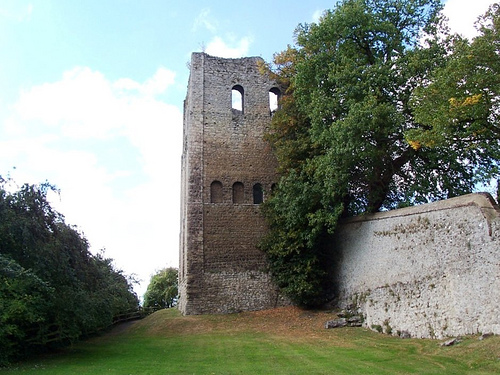
West Malling contains several historic buildings, including St Leonard's Tower, a Norman keep built by Bishop Gundulf (bishop between 1077 and 1108).[3] He also built the White Tower of the Tower of London, the castles of Rochester and Colchester, and the Priory and Cathedral of Rochester. In c.1090, Gundulf founded St. Mary's Abbey in West Malling for Benedictine nuns. This historic site contains significant buildings from the Norman, medieval, Tudor and Georgian eras. There is also a Grade II* listed 1966 abbey church which is used by the Anglican Benedictine nuns, who have made Malling Abbey their home since 1916.

Other buildings of interest in West Malling include the Prior's House, once a residence for those with leprosy; Ford House, over 600 years old; a mainly Georgian High Street; the Swan Hotel,[4] an 18th-century coaching inn (Grade II listed); and Went House, built c.1720 and noted for its elegant brickwork. Manor Park Country Park is just to the south of the town, close to St Leonard's Tower and Douce's Manor, whose grounds the park once comprised.

In about 1791, the artist J. M. W. Turner painted a watercolour of 'St Mary's Abbey and an ornamental waterfall' on Swan St, that remains in place today.[5]

Places of worship include the Anglican St Mary's Church[6] and West Malling Baptist Church, built in 1836.[7]

Kings Hill

[edit]

This new parish is a mixed residential housing estate and commercial development formed from parts of West Malling, Mereworth, East Malling and Wateringbury. The 2004 Wealth of the Nation report lists Kings Hill as having the highest average income and the highest proportion of households earning more than £100,000 per annum in Great Britain.

Transport

[edit]
West Malling station

West Malling is some 35 miles (56 km) from central London, next to the main road between London and the coastal ferry ports of Folkestone and Dover. There are good links by road and rail; the area has become a popular commuter location.

Railway

[edit]

West Malling station is a stop on the Kent Downs line, situated on the outskirts of the town. Southeastern Trains provides a regular service between London Victoria, Maidstone East and Ashford International; journeys into London take around one hour.[8]

With the recent development of Kings Hill, the station is sometimes known as West Malling for Kings Hill; road access was provided in 2007 from the West Malling bypass, taking commuter traffic away from the High Street.

Road

[edit]

The town was established originally on the main road between London and the Kent coast. West Malling is sited about 1 mile (1.6 km) from junction 4 of the M20 and from junction 2 of the M26, which leads on to the M25 London Orbital motorway.

Buses

[edit]

Bus services are provided predominantly Arriva Kent and Surrey and Nu-Venture. Routes connect the town with Chatham, Maidstone, Rochester and Tunbridge Wells.[9]

Air

[edit]

In the 1930s, Maidstone Airport was established two miles from the town, at King Hill. During the Second World War, RAF fighters were posted to the then-named RAF West Malling and several US Navy squadrons were located there during the 1960s. After closure as an operational airfield in 1967, several commercial air-based activities moved onto the site and a number of popular airshows took place; the last was in 1987. By then, work had started to convert the area to non-flying use, developing into the new parish of Kings Hill.

Healthcare

[edit]
Three service awards for nurses who worked in the Kent Nursing Institute: member, five and ten year service

Kent Nursing Institute was founded in 1875 in West Malling as a private nursing service; it also had a branch in Tunbridge Wells.[10] Funding was sourced via charitable donations, subscriptions and one-off payments. There was a nursing institute in West Malling from at least 1881 until the end of the First World War.

In 1881, Eva Luckes, Matron of The London Hospital was asked to train some probationers from the institute ward based training at The London.[11] Nurses were awarded five (bronze) and ten (silver) badges for long service.

The Tunbridge Wells branch was in Crescent Road and was an auxiliary hospital during the First World War, with beds for civilians and soldiers.[12]

Notable staff

[edit]
  • Agnes Theodosia Kelly (1863–1929) was Lady Superintendent / matron of the West Malling branch between 1902 and 1916.[13] Kelly trained at The London Hospital under Luckes between 1889 and 1891.[14][15] Kelly was also Lady Superintendent of Kent VAD Hospital 150, based in West Malling, Kent until at least January 1919.[16]

Local media

[edit]

Newspapers

[edit]

West Malling is covered by the Malling edition of the Kent Messenger, published by the KM Group. There is also a King's Hill edition of the Sevenoaks Chronicle.

Television

[edit]

Local news and television programmes are provided by BBC South East and ITV Meridian. Television signals are received from the Bluebell Hill TV transmitter,[17] BBC London and ITV London can also be received from the Crystal Palace TV transmitter.[18]

Radio

[edit]

The local radio station for West Malling is KMFM Maidstone. The county-wide stations BBC Radio Kent, Heart South and Gold can also be received in the town.

Sport

[edit]

West Malling is reputed to be the site of the first recorded cricket match in Kent. The Old County Ground, off Norman Road, was once the home of inter-county cricket in Kent; it is known that in 1705, West of Kent played Chatham at Malling.

The setting for the cricket match between All Muggleton and Dingley Dell, in Charles Dickens' The Pickwick Papers, is reputed to be based on an amalgamation of the grounds at West Malling and Maidstone. There is a resemblance to West Malling in the original illustration of the match, a version of which featured on the back of the £10 banknote featuring Dickens, first circulated on 29 April 1992. Dickens, however, was a regular visitor to Dingley Hall in the village of Dingley, Northamptonshire. Here he would have encountered an annual cricket match against a team formed of men with the name Muggleton, from the next village of Wilbaston. Dingley Dell is an area just south of the village, steep and wooded which may instead have been the model for Dickens' "Dingley Dell".[citation needed]

King's Hill golf course was founded in 1995 and is open to guests and visitors.[19]

Cultural references

[edit]

Notable residents

[edit]
  • Aretas Akers-Douglas, 1st Viscount Chilston, Conservative politician and Home Secretary 1902–1905. Born at St. Mary's Abbey, West Malling in 1851.
  • John Downman, artist. Lived in Went House, West Malling from 1804.
  • Wing Commander Guy Gibson, Victoria Cross recipient and leader of The Dambusters, was stationed at RAF West Malling in 1941. His signature is preserved on the ceiling of the cellar at Douce's Manor, used as an Officers' Mess by the Airmen.
  • Tony Hudgell, fundraiser, lives with his adoptive parents in Kings Hill.
  • William Perfect, surgeon, obstetrician and pioneer of the treatment of mental illness. Lived in West Malling from 1756 until his death in 1809.
  • Lt. Col. A.D. Wintle, famous eccentric and soldier. First layman to win a unanimous verdict in the House of Lords. Lived in Coldharbour House in West Malling.
  • Gladys Wright, an advocate for women's physical education was born here in 1891.[21]

References

[edit]
[edit]
Revisions and contributorsEdit on WikipediaRead on Wikipedia
from Grokipedia
West Malling is a historic and in the district of , , situated on the northern dip slope of the approximately 5 miles west of and 30 miles southeast of . With a of 2,553 as recorded in the 2021 , it spans 383 hectares and features a density of 667 people per square kilometer. The town, historically known as Town Malling, developed as a medieval settlement centered around its religious and administrative significance, retaining a charming high street lined with independent shops, cafés, and monthly farmers' markets. The area's defining historical feature is St Mary's Abbey, a Benedictine nunnery founded around 1090 by Gundulf, , and dedicated in 1106, which played a central role in the region's ecclesiastical until its dissolution in 1538 during the reign of . Surviving elements include a 14th-century and , a Norman tower, and a 13th-century arcade, with the site now encompassing a , Grade I listed medieval structures, and an 18th-century cascade. Nearby, St Leonard's Tower, constructed between 1077 and 1108 by the same Bishop Gundulf as a fortified residence, stands as one of England's earliest Norman keeps and is managed by . These landmarks underscore West Malling's medieval importance within the hundred of Larkfield and lathe of Aylesford, where it served as a hub for trade and pilgrimage. Geographically, West Malling lies south of the and northeast of the , contributing to the borough's diverse landscape of countryside parks like Manor Park and Leybourne Lakes, which offer recreational spaces amid rolling hills and reservoirs. The town's connectivity is enhanced by West Malling railway station, opened in 1874 on the Maidstone Line, providing links to London Victoria and Ashford International. In modern times, West Malling balances its heritage with contemporary amenities, including a range of restaurants, pubs, and educational facilities, while former airfield, operational during as a night fighter base, now redeveloped as the Kings Hill residential and business community. This blend of ancient roots and vibrant community life defines the town's character as a sought-after residential and visitor destination in .

History

Medieval origins

The name West Malling derives from the meallaingas, meaning "the people of Mealla," referring to an early settler or tribal leader, with the settlement first recorded as "Mallengetis" in the of 1086. This early Anglo-Saxon foundation evolved into a distinct westward of East Malling, reflecting typical Kentish patterns of tribal groupings in the landscape. Following the of 1066, West Malling saw significant development under Norman ecclesiastical influence, particularly through Bishop Gundulf of Rochester, who played a key role in consolidating control in . Around 1077–1108, Gundulf constructed St Leonard's Tower as a , likely part of a small castle or fortified precinct, featuring characteristic thick walls and a square design typical of early post-Conquest military architecture. The tower, standing to its full height of about 60 feet, served defensive purposes amid the region's strategic position near Rochester. Circa 1090, Gundulf founded St Mary's Abbey as a Benedictine nunnery, establishing it as a central religious institution that shaped the town's identity until its dissolution in 1538. The abbey complex included a church dedicated in 1106, with surviving medieval elements such as the 12th-century south wall and , rebuilt after a in 1190, and a square-ended east end featuring a central rectangular . Architectural highlights encompassed a 13th-century south arcade and parts of the chapter house and dorter in the east range, alongside a 14th-century , all arranged around a traditional layout that facilitated monastic life and community interaction. The received a market around 1103 from King Henry I, granting a weekly market, which the held as a prescriptive right by 1312; this was later confirmed in charters of 1347. This established West Malling as a , fostering trade in agricultural goods and from surrounding Kentish estates. The also controlled fairs on key saints' days, such as St Leonard's (6 November) and St Peter's ad Vincula (1 August), further boosting economic activity. As a major landowner, St Mary's Abbey exerted considerable influence on the local economy through its manors, tithes, and market oversight, which supported agricultural production and regional commerce in medieval . In governance, the administered manorial courts and held jurisdictional rights over the town, integrating religious authority with secular administration and ensuring the nunnery's role in maintaining order and welfare among tenants until the early .

Post-medieval developments

The under resulted in the closure of St Mary's Abbey in West Malling on 28 October 1538, after which the property was surrendered to by Margaret Vernon, following the earlier resignation of Elizabeth Rede in 1536. Substantial portions of the medieval abbey were partially demolished, and surviving masonry was repurposed in subsequent secular buildings, including farm structures and a new house erected on the south range in the . These adaptations transformed the ecclesiastical complex into domestic and agricultural uses while preserving elements of its Norman and medieval fabric. By the , West Malling experienced urban refinement, particularly along the , where proliferated amid the town's economic stability. Elegant timber-framed and brick-built properties, often with windows and symmetrical facades, emerged as coaching inns and residences, exemplifying the period's neoclassical influences. Structures like The Old Vicarage, a Grade II-listed 18th-century house, highlight this development, contributing to the street's cohesive historic character. The town's charm was artistically documented in 1791 by the 16-year-old , who produced watercolour sketches including "The Cascade with St Mary's Abbey," depicting the abbey's ruins alongside a local ornamental water feature and surrounding landscape. These works, now held by , underscore West Malling's picturesque appeal during Turner's early career focused on architectural and natural subjects. Market activities, rooted in medieval charters granted to the abbess, persisted and expanded from the 17th to 19th centuries, supporting the town's role as a commercial hub in 's fertile Valley. , particularly fruit cultivation such as cherries and apples, integrated into economies, with small-scale orchards boosting local trade and prosperity amid broader regional advancements in . In 1705, West Malling hosted 's first recorded organised match, an 11-a-side contest between a West Kent team and Chatham played on the Old County Ground, signaling the sport's growing popularity in the county.

20th century and modern era

In the early , West Malling saw the development of infrastructure when a ground, initially known as Kinghill, was established in 1930 for the School of Flying. This site, located amid Kent's orchards and hop gardens, expanded into a municipal by 1937 before being requisitioned by the Royal Air Force at the outset of , officially becoming in June 1940. The airfield quickly served as an advanced aerodrome supporting nearby stations like RAF and during the in 1940, though it was not fully operational at the campaign's start and suffered bombing damage that delayed full readiness. By 1941, had emerged as the RAF's premier night-fighter base, hosting squadrons equipped with aircraft such as the , , and Douglas Havoc, later transitioning to night fighters with advanced AI radar systems. These units played a critical role in defending against night raids and, in 1944, intercepting V-1 flying bombs during the later stages of the war. The station's contributions included notable successes in radar-guided interceptions, underscoring its importance in Britain's nocturnal air defense strategy. Following the war, remained active for training and auxiliary operations until its closure as an operational station in 1969, with the U.S. Navy using parts of the site until 1967. Initial development plans focused on civilian , including air displays and activities, while the airfield was sold to local authorities in the early for potential industrial and housing reuse. In 1967, the disused airfield gained cultural prominence when filmed key sequences for their project there, including the surreal "I Am The Walrus" performance amid anti-blast walls and the interior "Mystery Marathon" scenes in a converted hangar. The construction of the in the 1960s further transformed West Malling's connectivity, with sections bypassing —including junctions 5 to 8—opening between 1960 and 1961, providing faster links to and coastal ports. This infrastructure boom facilitated West Malling's evolution into a desirable , contributing to sustained in the borough from approximately 100,000 in 1981 to 132,200 by 2021, driven by housing expansions and proximity to employment hubs. Since the 1980s, the town's appeal as a residential base for workers has spurred housing developments, with the local population rising from around 2,000 in the early 1980s to 2,554 by 2021.

Geography

Location and landscape

West Malling is situated in the district of , , approximately 31 miles (50 km) southeast of and 7 miles (11 km) west of . The town lies within the broader west-central landscape, positioned to the south of the escarpment and to the northeast of the lowlands. The settlement occupies the Malling valley, a gentle lowland corridor flanked by the rising chalk hills of the to the north and the undulating Low Weald terrain to the south. This positioning places West Malling adjacent to the southern boundary of the Kent Downs Area of Outstanding Natural Beauty, a designated protected landscape characterized by its rolling chalk ridges, dry valleys, and expansive views across rural . The town's topography features a subtle slope descending from the north towards the historic core, where the site of the medieval abbey serves as a focal point amid surrounding arable farmland and hedgerow fields. Approximately 2 miles to the north, the River Medway marks a significant hydrological boundary, with its influencing the local drainage and contributing to the valley's fertile character. Key natural sites in the vicinity include pockets of and managed green spaces, enhancing the area's . Geologically, the region reflects Kent's classic , with underlying chalk formations of the giving way to clay-rich Weald deposits in the valleys; these contrasts have historically shaped settlement by favoring elevated, well-drained sites for early development while supporting in the lower, loamy soils.

Climate and environment

West Malling features a temperate characteristic of southeast , with mild s and moderate throughout the year. The average annual temperature is 10.6°C, with winter lows averaging around 2°C and summer highs reaching 21°C. Annual rainfall totals approximately 726 mm, contributing to lush vegetation but occasional wet conditions. The town's location approximately 4 km south of the influences its microclimate, with the chalk hills providing shelter that moderates winter temperatures and elevates local humidity levels compared to more exposed inland areas. Surrounding parts of West Malling lie within the Downs Area of Outstanding Natural Beauty (AONB), a designation aimed at conserving the distinctive landscape of chalk hills, woodlands, and valleys while supporting and recreation. The historic core of the town is protected by the West Malling Conservation Area, established in 1971 and extended in 1990 and 1993, which safeguards over 200 listed buildings and traditional street patterns from inappropriate development. Local biodiversity efforts focus on preserving habitats in the abbey grounds and adjacent woodlands, where ancient trees, wildflower meadows, and streams support species such as butterflies, birds, and small mammals. Nearby sites like Woods Meadow and Leybourne Woods, managed as public open spaces and , enhance ecological connectivity through volunteer-led conservation and habitat restoration projects. Manor Park Country Park, encompassing diverse grasslands, wetlands, and hedgerows, further bolsters these initiatives by providing accessible green space for monitoring and . Flooding poses a notable environmental challenge, particularly from the East Malling and Ditton Stream, which can overflow during intense rainfall and affect low-lying areas in West Malling, as evidenced by recurrent incidents along routes like New Road. In addressing broader vulnerabilities, Borough Council declared a and in 2019, launching a strategy for 2020–2030 that promotes energy efficiency, , and resilience measures across the borough, including West Malling. The West Malling Parish Council aligns with these efforts, committing to zero-net carbon operations by 2030 through local , waste reduction, and community engagement programs.

Demographics

The population of West Malling has shown relative stability over recent decades, with 2,383 residents recorded in the 2001 , rising to 2,590 in 2011 before a slight decline to 2,554 in 2021. This represents an annual change rate of -0.14% between 2011 and 2021, influenced by limited new housing developments within the boundaries. In contrast, the broader West Malling ward, encompassing adjacent areas including parts of Kings Hill, experienced notable growth, reaching 4,256 residents in 2021 and reflecting an annual population change of 3.7% over the decade. Historical data indicate slower growth in earlier periods, with the parish population at 2,021 in 1851 and 2,086 in 1861, suggesting modest expansion through the amid agricultural and activities. Acceleration occurred post-World War II, driven by inward migration from as commuting patterns emerged, supported by the town's proximity to motorways facilitating easier access to urban centers. Projections under the Tonbridge and Malling Local Plan anticipate continued growth in the West Malling area, aligned with borough-wide housing targets of 19,746 new homes by 2042 to accommodate a 37% increase in households.

Ethnic and social composition

According to the 2021 Census, the ethnic composition of West Malling reflects a predominantly population, with 95.3% identifying as (primarily ), 2% as Asian, 2.1% as mixed or multiple ethnic groups, 0.6% as Black, 0.2% as Arab, and 0.1% as other ethnic groups. This aligns closely with the broader district, where 93.3% identified as in the same census, indicating low ethnic diversity compared to national averages. The area ranks among England's 20% least deprived districts on the Index of Multiple Deprivation, with minimal pockets of socioeconomic disadvantage. The age structure in West Malling shows 18% of residents under 18 years old, 52.4% aged 18–64, and 29.7% aged 65 and over, contributing to a mean age of 45.7 years. This ageing profile is slightly older than median of 42 years, where similar proportions hold, with around 60% in working age reflecting stable family-oriented communities. balance is near parity, with 54% female residents. Household types emphasize homeownership and family units, with 70% of dwellings in Tonbridge and Malling owner-occupied (either outright or with a ), higher than the national average of 63%. Families constitute a significant share, around 45% of , supporting a focused on long-term residency. Median in the district stands at approximately £38,000 annually, exceeding Kent's county average and underscoring relative affluence. Social trends include a rising prevalence of multigenerational households, mirroring the national increase from 1.8% in 2011 to 2.1% in 2021, driven by costs and family support needs. Health metrics indicate strong outcomes, with at birth averaging 80.7 years for males and 84.3 years for females in (2021–2023 data), surpassing national figures of 79.1 years for males and 83.0 years for females. These rates reflect the area's low deprivation and access to quality healthcare, contributing to above-average .

Governance

Parish and borough administration

West Malling is governed at the parish level by the West Malling Council, an elected body responsible for delivering community services such as the management of allotments, organization of local events, and maintenance of public amenities like the village hall and meadows. The council operates through its full council meetings, which are held on the first Monday of every month at 7:30 PM in the West Malling Village Hall, allowing councillors to discuss and decide on parish matters. The parish boundaries of West Malling include the historic town core along with adjacent rural areas, forming a defined within the broader district. At the district level, the Borough Council manages key services including planning permissions, housing provision, and across the area, with its administrative headquarters situated at the Gibson Building in Kings Hill. Overarching these is , under which West Malling falls within the Malling North electoral division; the county council delivers wider services such as road maintenance, social care, , and infrastructure. In recent years, the parish has pursued enhanced local control through the West Malling Neighbourhood Plan, an initiative by the council to shape development policies on , green spaces, and community facilities, following the designation of the neighbourhood area in 2016.

Political representation

West Malling falls within the East Malling, West Malling and Offham ward of Borough Council, represented by three Liberal Democrat councillors: Trudy Dean, Roger Roud, and Michelle Tatton. These councillors were elected in the 2023 local elections, reflecting a shift from previous Conservative representation in the area. At the county level, the Malling North division of , which encompasses West Malling, is represented by Sian Dodger of , who won the seat in the May 2025 election with 37% of the vote, defeating the Conservative candidate. Prior to 2025, the division had been held by Conservatives since the early 2000s. West Malling is included in the and Malling parliamentary constituency, represented by Helen Grant of the Conservative Party, who has held the seat since the July 2024 . In that election, Grant secured 30.5% of the vote in the new constituency boundaries. Voting trends in West Malling have historically favored Conservatives, with 62.8% support for the Conservative candidate in the within the former constituency that covered the town—a figure higher than Kent's approximate average of 55% for the party that year. Local issues, particularly the protection of the surrounding the town, have played a significant role in shaping voter preferences, as evidenced by joint petitions from West Malling and neighboring parish councils urging extensions to safeguard rural landscapes from development. Politically, the area experienced Liberal influences during the , aligned with broader trends in West Kent where grassroots Liberal and Conservative competitions were prominent. This gave way to Conservative dominance in the 20th century, particularly after , a pattern that persisted in local and national elections until recent shifts. The West Malling Parish Council provides the foundational structure for community-level political engagement.

Economy

Historical economy

During the medieval period, West Malling's economy was closely tied to the estates that later became those of Malling Abbey, a Benedictine nunnery founded around 1090 by Bishop Gundulf of Rochester. The bishopric's lands in the area, as recorded in the of 1086, included significant arable farming with 3 carucates of land, supporting a primarily agricultural base that likely extended to amid Kent's prominent wool trade. The abbey received a in 1105 granting a weekly market, confirmed by Edward III in 1347, along with rights to a Tuesday market and several annual fairs, which bolstered local trade in agricultural products. From the 17th to 19th centuries, the town's economy diversified with the rise of hop growing, , and related activities, fueled by its position along the London-to-Dover road. The Malling area became known for hop cultivation, highlighted by the discovery of the Golding hop variety around the late 1770s in the vicinity of East and West Malling, which gained commercial importance for by the 1780s and contributed to Kent's leading role in England's hop production. Coaching inns, such as those serving travelers on the historic route, provided essential services and lodging, supporting trade and transit economies. The 19th-century sector expanded regionally, with Maidstone-based firm Style & Winch Ltd—formed in 1899 and acquiring numerous Kentish pubs, including in West Malling—operating until brewing ceased in 1960. The arrival of the railway at West Malling station in 1874, part of the Maidstone Line, significantly improved goods transport for local , enabling efficient shipment of produce like and to markets and reducing reliance on road haulage. The town's enduring rural economic character underscored its agrarian focus.

Current industries and employment

West Malling's economy is characterized by a strong commuter base, with many residents traveling to and for employment due to excellent rail connections from West Malling station, which offers journeys to London Victoria in approximately 50 minutes. In the surrounding borough, the employment rate for residents aged 16-64 stands at 81.7% as of the 12 months ending March 2024. The borough's key economic sectors include , scientific, and technical activities (accounting for 17.3% of businesses), (13.5%), and administrative and support services (12.1%), reflecting a shift toward service-oriented and knowledge-based industries. Retail and services dominate local employment at around 25%, followed by at 20% and at 15%, supporting a (GVA) per head of £36,690 in 2023—higher than the average of £27,907. Business developments such as Endeavour Park, a modern landscaped site offering office and industrial units near the A20 and M20 motorways, bolster local commercial activity in West Malling. The adjacent Kings Hill , built on a former RAF airfield, further influences employment through its office spaces housing major firms like Rolex's headquarters and attracting over 50 businesses to the area. Unemployment in Tonbridge and Malling remains low at 2.3% as of March 2024 (claimant count), contributing to minimal deprivation levels across the borough. Tourism, driven by West Malling's historic sites such as the medieval St Leonard's Tower and the former Benedictine priory, supports the local economy; the sector generated £186 million annually in the borough as of 2023, with visitor spending on heritage attractions providing a notable boost.

Education

Primary education

West Malling Primary School serves as the main primary institution in the town, catering to children aged 4 to 11 as part of the Tenax Schools Trust. It converted to status on 1 September 2012 and currently enrolls 194 pupils in a mixed-gender setting. The school includes the McGinty Speech and Language Resource Provision, a specialist unit supporting pupils with speech and language needs. In its latest inspection on 24 January 2023, rated the school "Good" across all categories, highlighting effective leadership and pupil outcomes. Note that ceased providing overall effectiveness judgements for in September 2024. Nearby primary schools, such as Offham Primary School and Ryarsh Primary School, support education on the edges of the West Malling parish, providing additional capacity for local children aged 4 to 11. Offham Primary, a community school, has 201 pupils and traces its origins to a building constructed in 1875 and opened on 3 April 1876. Ryarsh Primary, also a community school, enrolls 209 pupils near the village of Ryarsh. Together, these institutions accommodate approximately 600 pupils in the broader area, with eligibility for free school meals varying: 30.9% at West Malling, 8% at Offham, and 11% at Ryarsh (as of October 2025). The in these schools aligns with the national framework, emphasizing core subjects like English, mathematics, and , where pupils develop skills in analyzing evidence and understanding concepts such as continuity and change. At West Malling, the program fosters curiosity through sequenced topics spanning ancient civilizations to modern events, integrating cross-curricular links to build comprehensive knowledge. Historical primary education in West Malling evolved from modest 19th-century schoolhouses, often single-classroom structures like Offham's original building, to expanded modern facilities following post-1950s developments under local authority guidance. Kent County Council provides oversight for admissions, standards, and support across these primary schools.

Secondary and further education

The primary secondary school serving West Malling is The Malling School, a mixed comprehensive foundation school for pupils aged 11 to 18 located in nearby East Malling. It caters to approximately 1,046 pupils and was rated "Good" overall by Ofsted in its inspection of March 2023, with "Outstanding" grades for behaviour and attitudes and personal development. Note that Ofsted ceased providing overall effectiveness judgements for state-funded schools in September 2024. The school's Key Stage 4 curriculum focuses on GCSE qualifications across a broad range of subjects, while its sixth form offers Level 3 pathways including the International Baccalaureate Diploma Programme (IBDP) and International Baccalaureate Career-related Programme (IBCP), emphasizing academic rigor and career preparation. STEM education is a key strength, with IB subjects such as biology, chemistry, mathematics, and computer science available alongside career-related options like applied science. For residents in West Malling and the adjacent Kings Hill development, The Malling School acts as the main provider, though some pupils may attend nearby alternatives such as Aylesford School or Wrotham School to accommodate capacity needs. In 2024 GCSE results, 32.8% of pupils achieved grade 5 or above in both English and mathematics, with an overall Attainment 8 score of 40.5—figures that reflect solid progress despite being below national averages (national: 45%). Prior to the widespread adoption of comprehensive education in the 1960s, students from the West Malling area typically accessed selective grammar schools within Kent, such as those in Maidstone, which influenced local educational expectations for academic selectivity. Further education options for West Malling residents are accessible via MidKent College in , approximately 5 miles away, which provides a range of vocational courses including apprenticeships, applied sciences, and professional qualifications in fields like and . The college emphasizes practical skills training aligned with local employment needs, supporting post-16 progression for school leavers. The Malling School enriches its offerings through extensive extracurricular activities, including over 60 clubs focused on and . Sports programs feature , tying into West Malling's local heritage with the historic Town Malling Cricket Club, founded in and one of Kent's oldest, fostering community links through inter-school matches and coaching initiatives.

Healthcare

Current facilities

The primary healthcare provider in West Malling is the West Malling Group Practice, an NHS with sites in Kings Hill and Leybourne, serving approximately 21,000 registered patients across the local area. It offers comprehensive services, including routine consultations, vaccinations such as flu and , and minor procedures like wound care and joint injections. The practice operates within the Malling Network under West , facilitating integrated care with other local providers. Pharmacy services are available at Boots on the (85-87 High Street), which provides prescription dispensing, over-the-counter medications, and additional NHS services like and minor ailment advice. Dental care is offered by practices such as One Smile Oral Care at 62 , delivering routine check-ups, cosmetic treatments, and services in a private setting. The nearest major is Maidstone , approximately 4 miles away, providing secondary care through the Maidstone and Tunbridge Wells NHS Trust for and specialist treatments; the Trust also operates an A&E at Tunbridge Wells in , about 16 miles away. Community mental health support for West Malling residents is provided by the and NHS and Social Care Partnership Trust, offering therapies, , and outpatient services accessible via referral from the local GP. Ambulance services are managed by the South East Coast Service NHS , with average response times for the most urgent (Category 1) incidents in around 8 minutes and 30 seconds. During the from 2020 to 2022, the West Malling Group Practice served as a center, administering doses to eligible local residents. Access to is strong, with over 3,000 patients registered at living within a one-mile radius of its branches, ensuring most residents in the town center are within easy reach. This modern infrastructure builds on earlier local health initiatives.

Historical developments

The provision of healthcare in West Malling during the was closely linked to systems, with the Malling Union , erected in 1836 to the south of the town, serving as a central for accommodating the destitute and delivering basic care, including treatment for the sick poor through resident medical officers and dispensaries. This system built upon earlier charitable traditions, such as the almshouses associated with the historic , which provided rudimentary support and to the needy in the locality. A pivotal advancement occurred in with the establishment of the Institute in West Malling, a private institution dedicated to training hospital-educated nurses for roles across rural , emphasizing home-based care for both wealthy families and the impoverished to address gaps in professional healthcare outside urban hospitals. The institute operated until the First World War, fostering a network of trained nurses who extended medical services into remote areas. Agnes Theodosia Kelly served as superintendent of the West Malling branch from 1902 to 1916, during which she oversaw the expansion of training programs, increasing the institute's capacity to produce skilled nurses and thereby strengthening community health support in . In the Second World War, the RAF airfield at West Malling assumed critical medical responsibilities as part of the Royal Air Force Medical Services, supporting operations with on-site facilities for treating casualties among aircrew and ground personnel amid intense night-fighting activities. Following the war, the creation of the in 1948 prompted significant shifts in local healthcare, integrating independent institutions like the Nursing Institute into the national framework and leading to the closure of such specialized training and district nursing operations by the mid-20th century.

Landmarks

Religious and monastic sites

St Mary's Abbey, also known as Malling Abbey, was founded around 1090 by Gundulf, , as a Benedictine nunnery, with the church dedicated in 1106. The site originally encompassed about 4.8 hectares, including a church, s, chapter house, dorter undercroft, fishpond, and guest house, reflecting its role as a self-contained monastic community. Surviving structures include a mid-12th-century Norman west front, a 13th-century south arcade, a 14th-century with an adjoining , and remnants of the south wall and transept of the original church; a medieval barn has been adapted as a . The abbey was dissolved in 1538 during the reign of , after which it passed to the , became Crown property, and was sold to the Honeywood family in 1620. It was restored in 1892 and has been occupied since 1916 by a community of Anglican Benedictine nuns, who maintain the site's monastic traditions in a modern abbey church built in 1966. The Parish Church of St Mary the Virgin, distinct from the abbey, traces its origins to at least 1086 as recorded in the , serving as a key ecclesiastical center under the . It features Norman elements, including the tower and western part of the , with the chancel lengthened in the late and the tower rebuilt in the early . The was rebuilt in Georgian style in 1778 following damage from a 1712 , and it underwent further Victorian restoration in 1901, consecrated by Archbishop William Temple and funded in part by the sale of the historic Malling Jug. Today, the church holds weekly services, baptisms, weddings, and community events, continuing its role as the parish's primary . The played a significant role in medieval pilgrimage, with a dedicated at the north end of the catering to visitors seeking spiritual solace at the nunnery. In modern times, the site supports retreats through the St Benedict's Centre, offering residential accommodations for silent prayer, reflection, and rest, as well as non-residential spaces for study, spirituality events, and group gatherings, upholding the Benedictine tradition of hospitality. Nonconformist chapels emerged in the amid growing religious diversity. The West Malling , serving the Baptist community, originated around 1832 when members from Borough Green Baptist Church established a presence, with formal services to 1836. The Old Methodist Church, built in 1875 by architects Cattermole & Eade with a added in 1897, represents Wesleyan Methodist influence and remains a Grade II listed building. West Malling's ecclesiastical parish falls within the Diocese of Rochester, specifically the Kent Downs and Malling Team Ministry, which encompasses seven parishes and shares boundaries with nearby areas like Mereworth, adjusted in 2015 to include parts of Kings Hill along Gibson Drive. Clergy records date back over 700 years, though early priests' names are largely unknown; notable modern figures include Team Rector Rev Canon Dr Helen Burn (appointed 2023).

Secular historic buildings

St Leonard's Tower stands as a prominent example of 12th-century Norman architecture in West Malling, constructed between 1077 and 1108 by Gundulf, Bishop of Rochester, as a fortified residence or castle keep. The structure is built from coursed Kentish ragstone rubble with tufa ashlar dressings, featuring a square design approximately 9.75 meters per side at the base; it survives to a height of around 20 meters, with the north and east faces reaching 60 feet and the south and west faces up to 70 feet. Original features include corner pilaster buttresses, a ground-floor round-headed entrance on the west side, round-headed windows, blind arcades, and an external spiral staircase turret with arrow loops, exemplifying early Anglo-Norman military design. Designated as a Scheduled Ancient Monument and Grade I listed building since 1993, the tower's lower floor, raised about 5 feet above ground level, provides evidence of its later use as a prison, possibly from the post-medieval period. The Georgian of West Malling features a collection of homes and shops that reflect the town's evolution as a prosperous market settlement, with many structures incorporating classical elements such as symmetrical facades, sash windows, and . Representative examples include several Grade II listed buildings, such as 17 , a timber-framed structure with later Georgian alterations dating to the early , and 84, 84A, and 86 , which showcase red-brick construction typical of the period's commercial . Historic pubs along the street, like the Five Pointed Star (originally from the but with significant refurbishments) and the Bull Inn at 1 (a with Georgian frontage additions), highlight the area's role in local trade and hospitality. These buildings contribute to the 's cohesive aesthetic, blending residential and commercial functions while preserving elements of West Malling's post-medieval prosperity. West Malling's , unveiled on 22 May 1921, commemorates local casualties of the First World War and stands as a civic in the town center. The structure is a stone cross on a base, originally approximately 14 feet high (current cross approximately half that height), set within a semi-circular enclosure in the wall, as described in contemporary records. Later additions honor Second World War victims, underscoring its ongoing role in community remembrance. The West Malling Conservation Area, designated in 1971 with extensions in 1990 and 1993, safeguards over 50 listed buildings and broader historic fabric, including the High Street's Georgian core and surrounding medieval street patterns, to maintain the town's architectural and spatial integrity. This status, managed by Borough Council, emphasizes the area's special architectural and historic interest, preventing unsympathetic developments that could erode its character. The control tower from the former airfield, constructed in 1942, represents a key secular remnant of the town's 20th-century military heritage and is one of the finest surviving examples of its type in . Built during the Second World War to oversee aircraft operations, the tower features streamlined concrete forms, horizontal window bands, and modernist detailing inspired by inter-war aviation architecture. Grade II listed since 2004, it was restored in the early 2000s and as of 2025 serves as a shop within the adjacent Kings Hill development.

Kings Hill

Development history

Kings Hill originated on the site of the former RAF West Malling airfield, which served as a key fighter and night-fighter base during World War II. In 1970, Kent County Council acquired the 800-acre site from the Ministry of Defence for £475,000, initially envisioning its reuse for aviation-related purposes before shifting toward residential and commercial development. By 1989, the council partnered with Liberty Property Trust to initiate a mixed-use project, transforming the brownfield location into a planned community adjacent to West Malling. Construction proceeded in phases starting in 1989, with residential building accelerating from the early 1990s onward. By 2010, approximately 2,000 homes had been completed as part of the original masterplan for up to 2,750 dwellings, with subsequent phases adding more and bringing the total to over 3,200 homes as of 2024. The community has since grown to encompass around 10,000 residents as of 2024, reflecting sustained expansion on the site. Kings Hill was established as a separate within the borough in the early , allowing for independent local governance distinct from West Malling. Development continues, with outline granted in 2024 for 65 additional homes on former airfield land and the portfolio sold to Praxis in late 2024. The development was conceived as a "" emphasizing integrated living and working spaces, with extensive green areas comprising over 30% of the site to promote and community cohesion. This approach drew inspiration from Garden City principles, incorporating varied housing styles, ecological enhancements like wildflower meadows, and preserved aviation heritage elements such as the refurbished control tower. Economically, the project has generated significant employment through Section 106 planning agreements, supporting around 5,000 jobs in the initial phases via 800,000 square feet of office and space occupied by over 300 companies. Integration with neighboring West Malling has presented challenges, including coordinated needs; for instance, direct road access to West Malling railway station was established in to better serve Kings Hill residents commuting to .

Community and amenities

Kings Hill is characterized by a high-income demographic, attracting professionals drawn to its modern amenities and business opportunities. The average household income in the area stands at approximately £68,700, reflecting its appeal to affluent residents. House prices average around £525,513, underscoring the premium nature of the market. This socioeconomic profile contributes to a focused on family-oriented living and work-life balance. The village offers a range of facilities that support daily resident life, including the Kings Hill Village Centre, which features a mix of retail shops, restaurants, a , and services within approximately 200,000 square feet of commercial . Educational amenities include three primary schools: Kings Hill School Primary and Nursery, The Discovery School, and Valley Invicta Primary School at Kings Hill, all providing comprehensive early in a community setting. Leisure options are centered around the David Lloyd Kings Hill club, which includes a 25-meter indoor , a 20-meter outdoor pool, facilities, and various fitness classes, alongside the Kings Hill Sports Park managed by tmactive for broader sports and community activities. Green spaces play a vital role in community well-being, with around 100 acres dedicated to parks and open areas, including the Warren Woods Nature Park and various woodlands that provide trails and natural surroundings. These spaces, integrated into the village's planning, enhance recreational opportunities and . The annual Kings Hill Music Festival, held since 2009 at The Spitfire pub, fosters social connections through live music performances and family-friendly events, drawing local residents together. As a distinct with its own Kings Hill Parish Council, the community maintains autonomy in local governance while benefiting from shared regional services, such as those provided by the broader borough, including proximity to emergency facilities in nearby West Malling. This structure allows for tailored community initiatives, like events at the Kings Hill Community Centre, while ensuring access to essential support networks.

Transport

Rail services

West Malling railway station, located on the East Line, provides essential rail connectivity for the town and the adjacent Kings Hill development. The station originally opened on 1 June 1874 as Malling station, built by the London, Chatham and Dover Railway as part of the extension from to . It was initially a rural facility with a single-track layout and a distinctive station building design, reflecting the line's role in serving agricultural communities in . The line through West Malling was electrified in 1939, enabling electric train operations that continue today. All passenger services at the station are operated by Southeastern, offering frequent connections on the route between and . Trains run hourly in each direction, with journeys to Victoria taking around 55 minutes and services extending to Ashford International, often using eight-car formations to handle peak demand. In the financial year 2023/24, the station saw 784,240 passenger entries and exits, reflecting its importance for commuters traveling to and supporting local growth in the area. Historically, the station supported freight operations, including goods traffic vital for transporting local agricultural produce from Kent's orchards and farms, until these services were withdrawn on 19 May 1964 as part of the broader Beeching-era rationalization of Britain's rail network. Passenger-focused infrastructure has since expanded, with a providing access to Kings Hill since the early 2000s, complemented by a direct road link from the West Malling bypass opened in 2007 to improve integration with the expanding residential area. Current facilities at West Malling include a ticket office staffed during peak hours (Monday to Friday 06:00–19:00, Saturday 07:30–14:10, and Sunday 08:15–15:30), self-service ticket machines on both platforms, step-free access via ramps, and a car park accommodating 164 vehicles. Bicycle storage for 64 cycles is also available, promoting sustainable travel options. Looking ahead, station enhancements are anticipated to address increasing patronage from nearby housing developments, ensuring capacity for future demand without major electrification works, as the line has been wired since 1939.

Road infrastructure

West Malling's road infrastructure has evolved significantly to accommodate both historic routes and modern connectivity. The , once part of the broader network linking to Dover via routes like the A25, now functions primarily as a local thoroughfare, with surrounding B roads such as St Leonard's Street serving residential and commercial access within the town. The town benefits from excellent proximity to major motorways, enhancing accessibility for commuters and freight. Junction 4 of the M20 lies approximately 1 mile north of West Malling, providing direct links to the M26 and A20, with reachable in about 32 miles via these routes. This positioning supports efficient travel to the capital and coastal areas, integrating West Malling into the regional network. A key development was the construction of the A228 Leybourne and West Malling Bypass, approved in at a cost of £28 million and completed in 2006. This 2.6 km diverts through-traffic from the town center, significantly reducing congestion on local roads like the and improving flow for residents. Post-opening assessments indicated lower traffic volumes on several internal streets, though some villagers noted persistent issues in adjacent areas. Road safety measures are prominent along the A228, which sees substantial enforcement through fixed speed cameras, particularly on Ashton Way. As of 2024, this stretch recorded 1,437 speeding fines in the preceding year, ranking it among Kent's top 20 roads for violations and contributing to broader efforts to curb excessive speeds. includes paths connecting to the nearby West Malling railway station, promoting sustainable local travel alongside the dominant car-based network. also facilitates safer cycling by separating high-volume traffic from town routes. Public bus services in West Malling connect the town to surrounding areas in , facilitating regional travel for residents and visitors. The primary route is the Nu-Venture 77, which runs between , Kings Hill, West Malling, and Hospital, operating on weekdays with services departing approximately hourly from West Malling . Arriva's 72 service provides additional links from to Kings Hill via West Malling, also running hourly and serving key stops along the A20 corridor. These routes support commuting and local errands, with timetables coordinated to align with peak travel times. For vulnerable groups, community transport options enhance accessibility. Dial2Drive, operated by in West Kent, offers a door-to-door minibus service for older adults and those with mobility challenges who cannot use standard public buses, utilizing volunteer drivers for pre-booked journeys within the local area. Fares for regular bus travel in include multi-operator day tickets like the Discovery Ticket, allowing unlimited rides across much of the county for an adult price of around £10, purchasable on board or via apps; contactless payments are widely accepted, though traditional cards are limited to zones and not integrated with Kent bus networks. Air travel access relies on nearby airports, as West Malling lacks its own operational airfield. London Gatwick Airport, the closest major international hub, lies about 35 miles to the north, reachable by car in approximately 36 minutes via the M20 and M25 motorways. For private and business aviation, is situated roughly 20 miles east, offering a 30-40 minute drive and specializing in flights. The historic site, once a key WWII base, ceased operations in and now serves industrial and residential purposes without aviation facilities. Airport connectivity includes from nearby to Gatwick, with onward bus links from West Malling adding about 30 minutes to the journey. Kent County Council's Local Transport Plan 5 promotes sustainable bus options across the county, including the of the Fastrack network in North (Dartford and Gravesham area) with 28 new electric buses that replaced diesel models by June 2025, improving air quality and reducing emissions on those routes.

Culture and leisure

Local media

West Malling is served by several local newspapers that provide coverage of community affairs, council decisions, and events in the town and surrounding Malling area. The Kent Messenger, published weekly by the KM Media Group, includes a dedicated Malling edition focusing on news from West Malling, East Malling, Ditton, and Larkfield, such as local government updates and business developments. This publication traces its origins to 1859, when it began as the Maidstone Telegraph, evolving into a key source for regional journalism in Kent. Additional local outlets include the monthly the local Oracle, which is hand-delivered to approximately 20,000 homes and businesses in the Malling area and features articles on community interests. The Kings Hill & The Mallings CommunityAd Magazine, also monthly, delivers updates on local news and events tailored to the district. For television, West Malling receives regional broadcasts from and via the Bluebell Hill transmitter, offering news segments that occasionally highlight local stories from the area. More targeted coverage comes from KMTV, a local channel operated by the KM Media Group in partnership with the , which airs programs like Kent Tonight and provides 24/7 news, sport, and entertainment relevant to and nearby towns including West Malling. Local radio options emphasize music, traffic updates, and talk content pertinent to West Kent. KMFM West Kent broadcasts on 101.6 FM in and 96.2 FM in , serving the district with hits, , and community announcements. BBC Radio Kent offers broader regional talk shows and bulletins that incorporate stories from the Malling area. West Kent Radio, on 95.5, 106.7, and 107.2 FM, provides hyper-local programming for , Tunbridge Wells, and surrounding villages, including coverage of events in West Malling. Historically, the Kent County Standard, founded in 1873 in , served as an early newspaper covering county-wide issues that extended to the Malling region. Contemporary media in West Malling has shifted toward digital platforms, with outlets like offering apps and online articles that prioritize local stories, such as abbey-related events, comprising a significant portion of content.

Sports and recreation

West Malling offers a variety of sports and recreational opportunities, centered around community clubs and facilities that cater to all ages. is a longstanding tradition in the area, with Town Malling Cricket Club, founded in 1827, based at the historic Old County Ground on Norman Road. This venue is notable as the site of the first recorded match in , played in 1705 between and . The club fields three men's teams, including a Saturday XI for friendlies and a Sunday team in the Kent Village Cricket League, alongside a women's team competing in the Kent Women’s Club T20 and a development side. Junior sections span from under-9s to under-15s, emphasizing skill development and competitive play. Golf enthusiasts can enjoy Kings Hill Golf Club, established in 1995 on heathland and woodland in the nearby Kings Hill area. The 18-hole championship course, designed by David Williams, features links-style turf with narrow fairways, well-drained USGA-spec greens, and a reputation as one of Kent's drier inland layouts. It provides practice facilities, a pro shop, and coaching through its Golf Academy for players of varying abilities. Football is actively supported at Kings Hill Sports Park in nearby Kings Hill, home to Kings Hill F.C., which fields men's first, reserve, and veterans teams, as well as a women's first team and youth squads from under-13 to under-18. The park includes grass and floodlit pitches suitable for training and matches, recognized by as one of Kent's top grassroots venues. is available through the Kings Hill Tennis Club, also at the sports park, which operates two dedicated floodlit hard courts and offers subsidized access to two more. The not-for-profit club promotes social sessions, team competitions, and coaching for adults and juniors. Key recreational facilities include the Kings Hill Sports Park, managed by tmactive, which encompasses fitness activities such as gym sessions alongside its multi-sport offerings. The West Malling Parish Council supports community sports infrastructure, including the provision of equipment on public grounds to encourage active lifestyles. Youth programs are integrated through local schools, such as West Malling Primary School, which utilizes the PE and Sport Premium funding to enhance and extracurricular activities. In the broader borough, adult sports participation rates hover around 23-25% based on surveys measuring at least 30 minutes of moderate activity once a week, reflecting steady . Local matches, including and football, occasionally receive coverage in regional outlets like Online.

Cultural events and references

West Malling hosts the annual Music@Malling , which brings international musicians to historic venues in and around the town, including , emphasizing classical and contemporary performances since its founding in 2011. The West Malling Festival, held each on the , features a light switch-on, live music, festive markets, fairground rides, and appearances by Santa, drawing thousands of visitors to celebrate the holiday season. The town has notable cultural references in popular media, particularly through ' 1967 film , where key scenes including the "I Am The Walrus" sequence and ballroom sets were filmed at the disused West Malling Air Station (now the site of Kings Hill). Local arts initiatives include exhibits at the Twitch Heritage Centre, managed by The Malling Society, which displays RAF memorabilia, wartime graffiti, and photographic collections highlighting West Malling's 20th-century history, open to the public several times a year. The area's landscapes inspired early works by , such as his 1791–1792 watercolour West Malling: St Mary's Abbey with the Cascade; a Study of Posts and a Signpost, leading to local guided tours and plaques that trace these artistic connections. In literature, West Malling features as part of the settings in ' The Pickwick Papers (1836–1837), where the fictional Dingley Dell and cricket match scenes draw inspiration from local landmarks like Town Malling (an older name for West Malling) and nearby Cob Tree Hall. Contemporary fiction includes The Witches of East Malling (2018) by Steve Higgs, a mystery novel set in the Malling area involving and local lore. Community theater thrives through Chip Productions, an amateur dramatic society that stages three productions annually, including plays and a traditional , at the West Malling Village Hall on Norman Road.

Notable people

Historical figures

Bishop Gundulf (c. 1024–1108), a Norman monk from the diocese of , served as from 1077 until his death. Renowned as a skilled and builder, he oversaw the reconstruction of starting in 1080, utilizing stone imported from quarries, and completed significant portions including the nave by 1083. In West Malling, Gundulf founded St Mary's Abbey around 1090 as a Benedictine nunnery, one of the earliest post-Conquest monasteries for women in , and is credited with constructing St Leonard's Tower between 1077 and 1108 as part of a small on a ledge overlooking the abbey. Joseph Bennett (c. 1811–1873), an player, was born in West Malling and became a champion, winning the first recorded professional billiards tournament in 1851 and dominating the sport in the mid-19th century. Edward Vesey Bligh (1826–1905), an English cricketer, was born in West Malling and played for and in the mid-19th century, appearing in first-class matches and contributing to early development. William Perfect (1737–1809) was an English physician, , and poet who established a medical practice in West Malling by 1757, initially as a , , and man-midwife. He pioneered humane treatments for mental illness at his private in , West Malling—later known as Dr Perfect's —which operated from his home and emphasized gentle therapies like music and exercise over restraint, influencing early psychiatric care. Perfect also contributed to literature, publishing and medical texts such as Select Cases in (1781), reflecting his broad interests in local Kentish life. John Downman (1750–1824), an English portrait painter known for his and watercolor works, resided in West Malling from 1804 to 1806 at Went House, inherited from his uncle. During this period, he produced numerous portraits of local families, including the Larkings of Clare House, capturing eight children in one notable group study, and pursued his interest in by sketching Kentish landscapes. Elected an Associate of the Royal Academy in 1795, Downman's time in West Malling marked a phase of relative seclusion before he relocated to the and later regions. Aretas Akers-Douglas (1851–1926), later 1st , was a British Conservative politician with deep family roots in West Malling, where his father served as rector of and the family resided at Malling Abbey during his early childhood. Educated at Eton and , he entered in 1880, rising to and under from 1902 to 1905, where he managed key reforms in policing and licensing laws. Created in 1911, Akers-Douglas maintained connections to throughout his career. Gladys (1891–1974), born in West Malling, emerged as an advocate for women's and community service during the First World War. She volunteered with the Red Cross Division, driving ambulances and organizing swimming galas to raise funds and entertain wounded soldiers, contributing to local wartime relief efforts until 1919. Later founding the School of Physical Education, 's early experiences in West Malling shaped her lifelong commitment to health and recreation initiatives. Wing Commander Guy Gibson (1918–1944), recipient of the Victoria Cross for his leadership in the Dambusters Raid during World War II, was stationed at RAF West Malling in 1941 as part of No. 29 Squadron, where he flew Bristol Beaufighters on night-fighter operations.

Contemporary residents

Tony Hudgell (born 2014), a young fundraiser and campaigner for child protection laws, was adopted by a family in West Malling and has raised over £1.8 million for Evelina London Children's Hospital, the facility that treated him after severe abuse as an infant; he was awarded the British Empire Medal in 2022 for his efforts. The , through their Gallagher Group founded in the , has been a prominent force in local development, master-planning the community on the site of the former airfield since 1989 and maintaining their headquarters in the town. (born 1973), the Conservative Member of Parliament for (which includes West Malling) since 2015, has served as , focusing on national defense and counter-terrorism policies. Andrew Fenn (born 1986), a former professional cyclist who competed for teams including Sky Procycling, grew up in West Malling and represented at the in the road race event.

References

Add your contribution
Related Hubs
User Avatar
No comments yet.