
Community hub
Recent from talks
Contribute something
Nothing was collected or created yet.
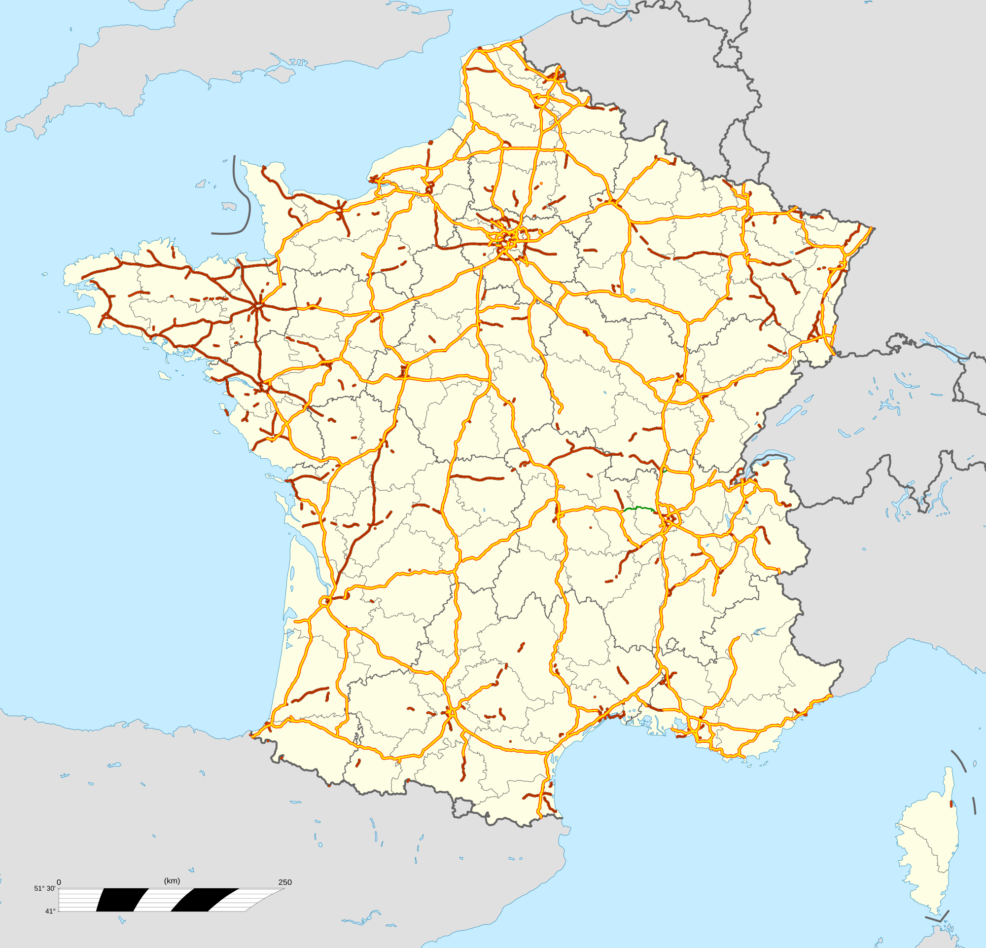
Autoroutes of France
View on Wikipedia
The autoroute (French: [otoʁut] ⓘ, highway or motorway) system in France consists largely of toll roads (76% of the total). It is a network of 11,882 km (7,383 mi) of motorways as of 2014. On road signs, autoroute destinations are shown in blue, while destinations reached through a combination of autoroutes are shown with an added autoroute logo. Toll autoroutes are signalled with the word péage (toll or toll plaza).


| ||
| Source: Observatoire national interministériel de la sécurité routière.[1] |
Length
[edit]| Network length (Privately managed & national statistics) | ||
|---|---|---|
| ||
| Source ASFA.,[2] ASFA 2018;[3] Eurostat (road_if_motorwa serie)[4] | ||
Numbering scheme
[edit]Unlike other motorway systems, there is no systematic numbering system, but there is a clustering of Autoroute numbers based on region.
A1, A3, A4, A5, A6, A10, A13, A14, A15, A16 radiate clockwise from Paris, with A2, A11, and A12 branching from A1, A10, and A13, respectively. A7 begins in Lyon, where A6 ends. A8 and A9 begin from the A7.
The 20s are found in northern and northwestern France. The 30s are found in eastern and northeastern France. The 40s are found near the Alps. The 50s are in the southeast, near the French Riviera. The 60s are found in southern France. The 70s are found in the center of the country. The 80s are found in western France, except for the A89 autoroute which goes from southwestern to eastern France.
Named routes
[edit]This section needs additional citations for verification. (February 2020) |

Autoroutes are often given a name, even if these are not very used:
- A1 is the autoroute du Nord (Northern motorway).
- A4 is the autoroute de l'Est (Eastern motorway).
- A6 and A7 are autoroutes du Soleil (Motorways of the Sun), as both lead from northern France to the sunny beach resorts of southern France.
- A8 is named La provençale as it cross the geographical region of Provence.
- A9 is named La Languedocienne as it crosses the geographic region of Languedoc and also La Catalane because it leads to the region Catalonia in Spain.
- A10 is named L'Aquitaine because it leads to Bordeaux and the region Nouvelle-Aquitaine.
- A11 is named L'Oceane because it leads to the Atlantic Ocean (Nantes).
- A13 is named the autoroute de Normandie as it traverses the region Normandy.
- A16 is named L'Européenne (the European) because it connects Paris with several European destinations such as the Belgium–France border, as well as Calais, which is connected with England.
- A20 is named L'occitane as it leads to the region Occitanie in south-west France.
- A21 is named the rocade minière (mining road) because it crosses the Nord-Pas de Calais Mining Basin, the largest mining stub in France.
- A26 is named the autoroute des Anglais (motorway of the English) as it connects Calais, the main point of arrival for cars and lorries from the UK, before continuing to Troyes, and through the Champagne region, whose wines are loved by the British. In addition, it passes near the sites of the most famous battles fought by the British Army in World War I, such as Arras, Cambrai, and the Somme and not far from Ypres and Mons in Belgium. It also passes sites of earlier UK interest such as Crecy and The Field of the Cloth of Gold.
- A35 is called l'Alsacienne or autoroute des Cigognes (Storks' motorways) as it passes only through the historical region of Alsace, for whom storks are a cultural symbol.
- A36 is called la Comtoise after the old region Franche Comté.
- A40 is named the autoroute blanche (white motorway) as it connects the French winter resort towns and the Alps.
- The A61 and A62 are named autoroute des deux mers (the two seas motorway) because these roads connect the Atlantic Ocean and the Mediterranean Sea from Bordeaux via Toulouse to Narbonne.
- A68 is called autoroute du Pastel because it leads to Albi and to the Lauragais where woad was cultivated to produce pastel.
- A71 is called L'Arverne.
- A75 is called La Méridienne.
- A77 is called Autoroute de l'Arbre.
- A84 is called Autoroute des Estuaires. It is part of the main route between Belgium and Spain, avoiding Paris.
- A104, one of Paris's beltways, is also known as La Francilienne because it circles the region of Ile-de-France.
Administration
[edit]The status of motorways in France has been the subject of debate through years, from their construction until recently. Originally, the autoroutes were built by private companies mandated by the French government and followed strict construction rules as described below. They are operated and maintained by mixed companies held in part by private interests and in part by the state. Those companies hold concessions, which means that autoroutes belong to the French state and their administration to semi-private companies. Vinci controls around 4,380 km (2,720 mi) of motorway. The different companies are as follows:
- ALIS (SEM, SAPN 8%, Bouygues 20.2%, Ixis 26%, DTP Terrassement 13.44%), operating the A28 Rouen-Alençon 125 km, Alis, official site
- SAPRR (Autoroutes Paris-Rhin-Rhône), 1801 km, SAPRR, official site
- AREA (Société des Autoroutes Rhône-Alpes, SAPRR Subsidiary at 99.82%), 381 km, AREA, official site
- ASF (Autoroutes du sud de la France), 2325 km, ASF, official site Archived 2006-12-06 at the Wayback Machine (bought by vinci-autoroutes.com Vinci)
- ATMB Autoroutes et tunnels du Mont-Blanc, 107 km, ATMB, official site
- CEVM (Viaduc de Millau, groupe Eiffage), 2.5 km, CEVM, official site
- Cofiroute (Compagnie Industrielle et Financière des Autoroutes, private company part of Vinci group), 896 km, Cofiroute, official site
- Escota (Société des Autoroutes Esterel-Côte d'Azur, ASF group), 460 km, Escota, official site (bought by vinci-autoroutes.com Vinci)
- Sanef (Société des autoroutes du Nord et de l'Est de la France), A.C.S. group (Spain), 1317 km, SANEF, official site
- SAPN (Société des autoroutes Paris-Normandie, SEM, groupe Sanef), 366 km, SAPN, official site
- SFTRF, Société française du tunnel routier du Fréjus, 67 km, SFRTF, official site
Only in the Brittany region do most of the autoroutes belong to the government. They are operated by the regional council and are free from tolls.
| Privately managed | |||||
|---|---|---|---|---|---|
|
| ||||
| Source ASFA[2] | |||||
Safety on French autoroutes
[edit]Motorway speed limits
[edit]France has the following speed limits for limited access roads classified as motorways:
- Under normal conditions - 130 km/h (80 mph)
- In rain or wet road conditions - 110 km/h (70 mph)
- In heavy fog or snowy/icy conditions - 50 km/h (30 mph)
Limited access roads classified as express roads have lower speed limit (90 or 110 km/h, 55 or 70 mph).
In normal conditions, there is a minimum speed of 80 km/h (50 mph) in the leftmost lane. There is no minimum speed on the others lanes, however the speed must be adapted to the conditions and not constitute a hazard by being too slow.
Safe design
[edit]
The autoroutes are designed to increase driver safety and allow for higher speed limits (130 km/h or 80 mph) than on regular roads (80 km/h or 50 mph) without increasing the risk of accidents.
The safety features include:
- one way driving: the lanes driving in the opposite direction are separated by at least a crash barrier designed to resist the oblique impact of a car at up to 180 km/h (110 mph); there are no intersecting roads but overpasses and underpasses;
- wider carriageways, with at least 2 (often 3) lanes driving in the same direction, with a larger turning radius - some recently built autoroutes have one-lane-only sections; for privately operated motorways, in 2017, the proportion is 6800 km (74%) in 2x2 lanes, 2252 km (25%) in 2x3 lanes, 84 km (1%) in 2x4 lanes.[2] Each lane is 3.5m wide.[5]
- long entrance and exit ramps or slip roads to get in or out of the autoroute without disturbing the traffic;
- an emergency lane, where it is forbidden to drive (except for emergency services), to park (except in case of emergency) and to walk;[6] Since 2000, new emergency lanes on newly built motorways should be 2.5m wide (or 3m if there are more than 2000 trucks a day). According to the 2000 standard, the emergency lane must be included in a 10m wide (8.5m for sections limited to 110 km/h) security zone without obstacles (in case the security zone includes an upwards slope, it is limited to the line where the slope reaches a height of 3m).[5]
- presence of emergency call boxes every 2 km (1.2 mi) on each side, that allow to call for help with the possibility to locate the call; some call boxes have flashing light that warn when there is a problem ahead;

- rest areas (aire de repos, i.e. car park with public toilets) every 10 km (6.2 mi) (4–6 minutes of driving) and service areas (aire de service with a least a gas station) every 40 km (25 mi) (20–30 minutes of driving) - on most recently built autoroutes these distances may be longer, up to 30/60km;
- regularly patrolling security services, to clear any obstacle and protect drivers in trouble (usually a breakdown or a flat tyre) with appropriate warning signs and beacons;
- dynamic information panels that warn about possible difficulties ahead (e.g. accident, roadworks, traffic jam);
- a radio station (107.7 MHz in FM) provides traffic information bulletins every 15 minutes (with a report in English in certain areas) and breaking news for emergencies;
- on heavy traffic days (e.g. beginning and end of school holidays), specific information and recreation events may be organised in rest areas;
- radars automatiques (speed cameras) are installed in many locations, and announced by a specific road sign.
Safety results
[edit]Fatalities on motorways have decreased between 2002 and 2016.
| Fatalities | ||
|---|---|---|
| ||
| Source ASFA[7][8] |
Fatalities accidents scenario
[edit]On French motorways, in 2016, 121 fatal accidents are direct/initial accidents representing 82% of fatal accidents, 16 (11%) fatal accidents occurs after a previous accident, and 10 (7%) fatal accidents occur after an incident.[8]
Three scenarios catch two-thirds of initial accidents:[8]
- A01 simple collision of two vehicle without direction change
- A06 crash on protection system such as safety traffic barrier
- A05 loss of vehicle control
Fatalities and accidents remaining factors
[edit]Most of fatalities occur by night.
| Fatal accident by Light condition | Fatal accident cause | ||||
|---|---|---|---|---|---|
|
| ||||
| Source Sécurité routière[9] | Source ASFA[2] |
Several factor of accidents are more highly probable by night in proportion to the traffic, although inattentiveness remains risky during the day.
| Influence of time on the risk of accident (% of accidents divided by % of traffic) | ||
|---|---|---|
| ||
| ||
| ||
| ||
| ||
| ||
| Source ASFA[8] |
Young drivers
[edit]Young drivers between 18 and 34 years old represent 19% of motorway drivers, but they are overrepresented in fatal motor vehicle collisions[7] and are involved in more than half of fatal accidents.[7]
| Involvement of young drivers in 2016, in fatal accidents | ||||||||
|---|---|---|---|---|---|---|---|---|
| young drivers in dangerous manoeuvre | young drivers in inattentiveness | young drivers in excessive speeding | ||||||
|
|
| ||||||
| Source ASFA[7] | ||||||||
Pedestrians
[edit]Although pedestrians are forbidden on motorways in conformity with the Vienna Convention, they are still sometimes killed on motorways.
In case a vehicle on a carriage cannot move, motorways safety rules remains applicable: it is forbidden for a pedestrian to travel on the motorway by article 421-2 from the "Code de la route" law.[10] For this reason, in case of accident or breakdown, it is advised to turn on hazard warning lights, wear high-visibility clothing, and go in a safer place such as the other side from the traffic barrier where there is no traffic. Since 2008, it is clarified that warning triangles are no longer mandatory when they would endanger the driver of the disabled vehicle.[11]
| Pedestrians killed in 2016 | |||||
|---|---|---|---|---|---|
| Place where pedestrians are killed | Reason for pedestrian presence | ||||
|
| ||||
| Source ASFA | |||||
Economics
[edit]
The toll roads were granted as concessions to mixed-economy corporations; the free roads are directly administered by the national government. Tolls are either based on a flat-rate for access to the road or on the distance driven. The latter case is the most common for long distances; users take a ticket from an automatic machine when they enter the autoroute, and pay according to the distance when exiting; toll booths accept multiple payment methods.

In 2005, the Villepin government proposed a controversial plan to sell all of the state's holdings in autoroute companies to private investors. Critics contend that the price announced is well below the profit forecasts for these companies, and thus that the government sacrifices the future to solve current budgetary problems.[12]
| Mode of payment | ||
|---|---|---|
| ||
| Source ASFA[2][3] |
List of autoroutes
[edit]| Number | Length (km) | Length (mi) | Southern or western terminus | Northern or eastern terminus | Route name | Formed | Removed | Notes |
|---|---|---|---|---|---|---|---|---|
| 211 | 131 | Paris (Porte de la Chapelle) | Lille (A25) | Autoroute du Nord | 1954 | current | Part of E 15 / E 17 / E 19 / E 42 | |
| 77.6 | 48.2 | Combles (A1) | Belgium | 1972 | current | Part of E 19 | ||
| 18.4 | 11.4 | Paris (Porte de Bagnolet) | Roissy-en-France (A1) | 1969 | current | Part of E 15 | ||
| 482 | 300 | Paris (Porte de Bercy) | Strasbourg | Autoroute de l'Est | 1970 | current | Part of E 17 / E 25 / E 46 / E 50 | |
| 225 | 140 | Vert-Saint-Denis (Seine-et-Marne) | Langres (A31) | 1983 | current | Part of E 17 / E 54 | ||
| 466.3 | 289.7 | Lyon (A7 / M7) | Paris (Wissous) (A6a / A6b) | Autoroute du Sud, Autoroute du Soleil | 1960 | current | Part of E 15 / E 21 / E 60 | |
| 312 | 194 | Marseille | Lyon (A6 / M6) | Autoroute du Soleil | 1951 | current | Part of E 15 / E 80 / E 714 | |
| 224 | 139 | La Fare-les-Oliviers (A7) | Italy | La Provençale | 1961 | current | Part of E 74 / E 80 | |
| 280 | 170 | Spain | Orange (A7) | La Languedocienne, La Catalane | 1960 | current | Part of E 15 / E 80 | |
| 557 | 346 | Bordeaux (A630) | Paris (Wissous) (A6a / A6b) | L'Aquitaine | 1960 | current | Part of E 5 | |
| 347 | 216 | Nantes | Ponthévrard (A10) | L'Océane | 1966 | current | Part of E 50 / E 60 / E 501 | |
| 8.5 | 5.3 | Trappes | Rocquencourt (A13) | Autoroute de Bretagne | 1950 | current | ||
| 226 | 140 | Caen (Porte de Paris) | Paris (Porte d'Auteuil) | Autoroute de Normandie | 1940 | current | Part of E 5 / E 46 | |
| 21.7 | 13.5 | La Défense | Orgeval (A13) | 1996 | current | |||
| 24 | 15 | Gennevilliers (A86) | Cergy | 1974 | current | |||
| 319 | 198 | L'Isle-Adam | Belgium | L'Européenne | 1991 | current | Part of E 40 / E 44 / E 401 / E 402 | |
| 131 | 81 | Orléans (Artenay) (A10) | Sens (A5) | L'Éco Autoroute | 1993 | current | Part of E 511 | |
| 428 | 266 | Montauban (A62) | Vierzon (A71) | L'Occitane | 1992 | current | Part of E 9 | |
| 58.9 | 36.6 | Aix-Noulette at an interchange with the A26 autoroute | Douchy-les-Mines (A2) | Rocade Minière | 1971 | current | ||
| 15.8 | 9.8 | Villeneuve-d'Ascq (A1) | Belgium | Autoroute du Nord | 1972 | current | Part of E 17 | |
| 42.7 | 26.5 | Lesquin (A27) | Trith-Saint-Léger (A2) | 1978 | current | |||
| — | — | Amiens | Belgium | 1980 | 2011 | Proposed, but never built | ||
| 62.7 | 39.0 | Lesquin (A1) | Dunkirk | 1963 | current | Part of E 42 | ||
| 395 | 245 | Troyes (A5) | Calais (A16) | Autoroute des Anglais | 1976 | current | Part of E 15 / E 17 / E 50 | |
| 13.7 | 8.5 | Lesquin (A22) | Belgium | 1973 | current | Part of E 42 | ||
| 366.5 | 227.7 | Abbeville (A16) | Tours (A10) | Autoroute des Estuaires | 2005 | current | Part of E 44 / E 402 / E 502 | |
| 183 | 114 | Le Havre (A13) | Saint-Quentin (A26) | 1995 | current | Part of E 44 / E 402 | ||
| 25 | 16 | Uckange (A31) | Crusnes | 1963 | current | |||
| 351 | 218 | Beaune (A6) | Luxembourg | 1966 | current | |||
| — | — | Freyming-Merlebach | Germany | 1972 | current | |||
| 26.8 | 16.7 | Nancy (A31) | Hudiviller | 1953 | current | Local autoroute around Nancy | ||
| 98 | 61 | Reims (A4) | Sedan | 1973 | current | |||
| 172 | 107 | Germany | Switzerland (Basel) | Autoroute des Cigognes | 1965 | current | ||
| 237 | 147 | Ladoix-Serrigny (A31) | Germany | La Comtoise | 1986 | current | ||
| 37 | 23 | Pouilly-en-Auxois (A6) | Dijon | La Côte-d'Orienne | 1973 | current | ||
| 144 | 89 | Dijon | Bourg-en-Bresse (A40) | Autoroute Verte | 1992 | current | ||
| 205.9 | 127.9 | Mâcon (A6) | Italy (Mont Blanc Tunnel) | Autoroute Blanche, Autoroute des Titans | 1973 | current | Part of E62 | |
| 112.9 | 70.2 | Switzerland (Geneva) | Grenoble | 1975 | current | |||
| 52.3 | 32.5 | Lyon | Bourg-en-Bresse (A40) | 1987 | current | Part of E611 | ||
| 208 | 129 | Lyon | Italy | 1973 | current | |||
| — | — | Bypassing Lyon to the west | — | — | ||||
| — | — | Lyon | Saint-Étienne | — | — | |||
| 47.6 | 29.6 | Anse (A6) | Givors (A7 / A47) (bypassing Lyon by east) | 1992 | current | |||
| 29.5 | 18.3 | Lyon (Givors) (A7 / A46) | Saint-Étienne | 1962 | current | Part of E70 | ||
| 52.5 | 32.6 | Lyon (A43) | Grenoble | 1968 | current | |||
| 70.4 | 43.7 | Grenoble | Valence | 1992 | current | |||
| 70 | 43 | Marseille | Toulon (A57) | 1962 | current | |||
| 172 | 107 | Marseille (A7) | Grenoble, Val de Durance | 1953 | current | |||
| 25.3 | 15.7 | Aix-en-Provence (A8) | Aubange (A50) | Great ring of Marseille | 1974 | current | ||
| 49 | 30 | Nîmes (A9) | Salon Sud (link with A7) | 1970 | current | |||
| 36.7 | 22.8 | Martigues | Marseille | 1972 | current | |||
| — | — | Link between A54 and A55 from Salon to Fos freight port | proposed | — | ||||
| 52 | 32 | Toulon (A50) | Le Cannet-des-Maures (A8) | 1964 | current | |||
| 147.5 | 91.7 | Toulouse (A62) | Narbonne (A9) | Autoroute des Deux Mers | 1978 | current | Part of E80 | |
| 242 | 150 | Bordeaux (A630) | Toulouse (A61) | Autoroute des Deux Mers | 1975 | current | Part of E72 | |
| 206 | 128 | Bordeaux (A630) | Spain | Autoroute de la Côte Basque | 1972 | current | Part of E05/E70 | |
| 287 | 178 | Toulouse (A620) | Bayonne (A63) | La Pyrénéenne | 1977 | current | Part of E80 | |
| 150 | 93 | Bordeaux (A62) | Pau (A64) | 2010 | current | Part of E7 | ||
| 38.2 | 23.7 | Toulouse (A61) | Pamiers | 2002 | current | Part of E9 | ||
| 61.9 | 38.5 | Toulouse (A62 / A61) | Albi | 1992 | current | |||
| 290.5 | 180.5 | Orléans (A10) | Clermont-Ferrand (A75) | L'Arverne | 1986 | current | ||
| 55 | 34 | Saint-Étienne | Balbigny (A89) | — | — | |||
| 335 | 208 | Clermont-Ferrand (A71) | Béziers (A9) | La Méridienne | — | — | ||
| 161 | 100 | Poligny (A6) | Nevers | Autoroute de l'Arbre | 1981 | current | ||
| 92 | 57 | Montmarault (A71) | Digoin | La Bourbonnaise | 2022 | current | Part of E 62 | |
| 94.8 | 58.9 | Le Mans (A11) | La Gravelle | 1982 | current | |||
| 152.5 | 94.8 | Nantes | Niort (A10) | 2001 | current | |||
| 170.5 | 105.9 | Caen (Porte de Bretagne) | Rennes | Autoroute des Estuaires | 2003 | current | Part of E 3 / E 46 / E 401 | |
| 270 | 170 | Angers (A11) | Vierzon (A71) | 1997 | current | |||
| 80.1 | 49.8 | Paris orbital | 2009 | current | ||||
| 129 | 80 | Angers (A11) | La Roche-sur-Yon | 2002 | current | |||
| 117.7 | 73.1 | Caen (Porte d'Espagne) | Sées (A28) | 2010 | current | |||
| 544 | 338 | Lyon (A6) | Bordeaux | 1991 | current | Part of E 70 | ||
| 2 | 1.2 | La Turbie (A8) | Monaco | 1992 | current | |||
| 9.7 | 6.0 | Ring of Marseille | 2016 | current | ||||
| 3 | 1.9 | Roquevaire (A52) | Auriol | — | — | |||
| 2 | 1.2 | One-direction ring of Marseille downtown | 1969 | current | ||||
Others
[edit]

- A1(972): Around Fort-de-France. Autoroute in Martinique, a French overseas territory.
- A104: The Francilienne around the Île-de-France (Paris) region
- A105: Combs-la-Ville
- A110: Ablis - Tours (proposed)
- A115: A15 (Sannois) - Méry-sur-Oise
- A131: Bourneville (A13 exit 26) - Le Havre
- A132: A13 / Pont-L'Évêque - Canapville
- A154: A13 - Louviers
- A199: Torcy - Champs-sur-Marne (downgraded to D199)
- A211: A21 - N17
- A216: A16/A26 - N216 Calais
- A320 : A4 - Germany
- A330: Nancy - Richardménil
- A391: A39 - RN83
- A404: Saint-Martin-du-Frêne - Oyonnax - Arbent
- A406: Mâcon
- A430: Chamousset - Gilly-sur-Isère
- A432: Saint-Laurent-de-Mure - Montluel
- A500: Tunnel (access to Monaco)
- A570: A57 - Hyères
- A620: A61 - A62 (West ring of Toulouse)
- A621: Toulouse - Blagnac
- A623: A620 - A61
- A624: Toulouse - Colomiers
- A630: Lormont - Bègles
- A631: Bègles
- A641: Oeyregave - Orthevielle
- A645: Ponlat-Taillebourg - Seilhan
- A660: Mios - Gujan-Mestras
- A680: Castelmaurou - Verfeil
- A710: Gerzat - Clermont-Ferrand
- A711: Lempdes - Pont-du-Château
- A712: Lempdes - Pont-du-Château
- A714: Bizeneuille - Saint-Victor
- A719: Gannat - Monteignet-sur-l'Andelot
- A750: A75 to Clermont-l'Hérault - Montpellier
- A811: Carquefou - Sainte-Luce-sur-Loire
- A813:Banneville-la-Campagne-Frénouville
- A831: Rochefort - La Rochelle - Fontenay-le-Comte
- A837 Autoroute des Oiseaux: Rochefort - Écurat (A10)
- A844: A11-A82
Radio coverage
[edit]
The FM 107.7 radio coverage is available in 2017 on 8902 kilometres of the (ASFA) network.[3] This is a list of highways that are updated in 107.7 FM every 15 minutes, live 24/7 (if the highway is said alone, it means that the station covers all around it):
Sanef 107.7 (1850km)
[edit]- Nord
- A1: Roissy-en-France - Carvin
- A2: A1 - Hordain
- A16: L'Isle-d'Adam - Boulogne-sur-Mer
- A26: Calais - Saint-Quentin
- A29: Neufchâtel-en-Bray - Saint-Quentin
- Est
- Ouest
- A13: Orgeval - Caen
- A14: Carrières-sur-Seine - Orgeval
- A29: (Beuzeville - Saint-Saëns; outside Normandy)
- A132
- A139
- A154
- A813
Autoroute INFO (2487km)
[edit]- Centre-Est (live from Dijon)
- A5: Lieusant - Langres
- A6: Fleury-en-Bière - Limonest
- A19: Courtenay - Sens
- A26: northern Troyes - southern Troyes
- A31: Beaune - Toul
- A36: Beaune - Mulhouse
- A39: Dijon - Bourg-en-Bresse
- A40: Mâcon - Bellegarde
- A46: Anse - Vaulx-en-Velin
- A71: Bourges - Clermont-Ferrand
- A77: A6 - Cosne-Cours-sur-Loire
- A105
- A311
- A391
- A406
- A411
- A430
- A714
- Rhône-Alpes (live from Chambéry)
Environment
[edit]99% of the privately managed network is protected by natural fencing.[3]
Privately managed motorways have 1764 wildlife crossing structures.[3]
See also
[edit]References
[edit]- ^ Bilan de l'accidentalité de l'année 2015
- ^ a b c d e 2017 CHIFFRES CLÉS (PDF) (Report) (in French). Association des sociétés françaises d'autoroutes - ASFA. 2017.
- ^ a b c d e 2018 CHIFFRES CLÉS (PDF) (Report) (in French). Association des sociétés françaises d'autoroutes - ASFA. 2018.
- ^ "Statistics - Eurostat". Eurostat. Retrieved 2024-03-01.
- ^ a b ICTAAL INSTRUCTION SUR LES CONDITIONS TECHNIQUES D'AMÉNAGEMENT DES AUTOROUTES DE LIAISON (PDF) (Report) (in French). Sétra - Service d'études sur les transports, les routes et leurs aménagements. 12 December 2000 – via DTRF - Documentation des Techniques Routières Françaises.
- ^ by definition motorways are forbidden to pedestrians
- ^ a b c d 2016 SÉCURITÉ SUR AUTOROUTE - ACCIDENTS MORTELS - CHIFFRES CLÉS (PDF) (Report) (in French). Association des sociétés françaises d'autoroutes - ASFA. 2016.
- ^ a b c d 2016 SÉCURITÉ SUR AUTOROUTE - ANALYSE DES ACCIDENTS MORTELS ET CORPORELS (PDF) (Report) (in French). Association des sociétés françaises d'autoroutes - ASFA. 2016.
- ^ "État de l'insécurité routière | Observatoire national interministériel de la sécurité routière". Observatoire national interministériel de la sécurité routière (in French).
- ^ Code de la route : Chapitre Ier : Autoroutes. (Articles R421-1 à R421-10), retrieved 6 August 2022,
I.-L'accès des autoroutes est interdit à la circulation :
- ^ "Gilet et triangle de sécurité". Ministère de l'Économie des Finances et de la Souveraineté industrielle et numérique (in French). 23 October 2020.
- ^ Press release of 12-14-2005 Archived November 20, 2006, at the Wayback Machine
External links
[edit]![]() Media related to Autoroutes in France at Wikimedia Commons
Media related to Autoroutes in France at Wikimedia Commons
- Official Website of the ASFA, with information on the Autoroute network and instructions on how to use them
- Motorway numbers in France (route log)
- The automatic tolling system in France: Liber-t
- Driving in France - autoroutes and other routes
- Go Camp France - List of French autoroute companies
Autoroutes of France
View on GrokipediaHistory
Origins and Early Development
In 1927, studies were initiated for the development of a "highway to the west" from Paris, laying the groundwork for what would become the A13, France's inaugural autoroute.[4] This project reflected early recognition of the need for dedicated high-speed roads separated from general traffic, amid growing automobile usage in interwar France. Construction commenced in 1935 on the initial segment between Paris-Saint-Cloud and Orgeval, approximately 15 kilometers in length, designed as a dual-carriageway with grade-separated access to facilitate safer, faster travel.[10] The engineering approach was informed by precedents such as Italy's autostrade, which pioneered motorway construction with the 1924 Milan-Laghi route, and American parkways emphasizing controlled-access roadways.[10] These influences prioritized divided lanes, limited entry points, and exclusion of non-motorized traffic to minimize accidents and enable higher speeds. World War II severely disrupted progress, with work halting amid resource shortages and military priorities, limiting completions to experimental stretches.[10] The Saint-Cloud-Orgeval section opened to civilian traffic in 1946, marking the operational debut of the autoroute system, though the network remained confined to under 100 kilometers of such nascent routes by the late 1940s due to postwar economic recovery challenges.[10]Post-War Expansion and Concession Model
The loi n° 55-435 du 18 avril 1955 established the statutory framework for French autoroutes, enabling the state to grant concessions for their construction, operation, and toll collection to mixed-economy companies (sociétés d'économie mixte, or SEM) while retaining ownership of the infrastructure.[11] This policy shift from direct state funding addressed post-war budgetary constraints, allowing private capital—combined with public interests from national and local authorities—to finance development without relying solely on taxpayer funds.[12] The first such SEM concessionaires emerged in 1956, marking the institutionalization of public-private partnerships for scaling the network.[12] Network expansion accelerated markedly in the 1960s and 1970s, with the total length growing from approximately 120 km in 1960 to over 900 km by 1968, driven by concession-financed projects.[13] Key routes like the A6, connecting Paris to Lyon, opened progressively starting with the initial Paris-Le Coudray-Montceaux section in 1960, followed by extensions into Seine-et-Marne by 1962 and further southward by 1967, facilitating inter-city links amid the industrial expansion of the Trente Glorieuses period.[14] By the 1980s, concessions had enabled the construction of thousands of additional kilometers, prioritizing high-traffic corridors to major urban and economic centers.[15] The concession model demonstrably expedited rollout compared to state-only alternatives, as evidenced by the completion of over 7,600 km of toll autoroutes by 2003—representing about 80% of the total network—through user-financed mechanisms that leveraged private investment efficiency. More than three-quarters of the 10,800-km motorway system originated from this 1955-initiated toll concession approach, yielding a network of superior quality and density relative to contemporaneous public-funded systems elsewhere, with concessions covering over 8,200 km by maturity.[3] This structure minimized fiscal pressure on the state while aligning incentives for timely construction and maintenance during the era's economic surge in logistics and mobility demands.[7]Modern Era and Recent Challenges
In the 1990s and 2000s, following the core network's establishment, French autoroute operators prioritized upgrading existing infrastructure to accommodate rising traffic volumes, including widening sections of heavily used routes and completing key links, with the total length expanding to over 12,000 km by the early 2010s.[16] Efforts targeted congestion hotspots, such as the A6 around Lyon, where the A6/A7 junction became one of the most bottlenecked urban axes, prompting junction expansions and link road additions like the A89-A6 connection completed in the 2010s to alleviate delays.[17][18] Technological integrations, including dynamic traffic management systems, further supported these mitigations by optimizing flow on saturated corridors.[19] More recently, innovations like free-flow tolling have been deployed to minimize stop-and-go traffic and associated emissions, with the system eliminating physical barriers on the A79 since November 2022 and expanding to the A13-A14 Paris-Normandy axis in 2024, allowing vehicles to maintain speed via overhead gantries and license plate recognition.[20][21] These upgrades reflect adaptation to denser usage, as annual vehicle-kilometers on autoroutes exceeded 200 billion by the 2010s, though they coincide with broader policy shifts amid expiring concessions.[22] Major concession agreements, covering over 90% of the network and held by operators like Sanef and Vinci subsidiaries, are set to conclude between 2031 and 2036, fueling debates over renationalization to recapture revenues—estimated at €10 billion annually—or extending private management for continued investment.[23][24] In this context, toll adjustments for 2025 averaged 0.92% across operators, capped at 70% of national inflation to balance revenue needs with affordability.[25][26] Contemporary hurdles include environmental litigation stalling expansions, exemplified by the A69 Toulouse-Castres project's three-month work suspension in February 2025 following a Toulouse administrative court ruling on inadequate biodiversity assessments, though the decision was stayed in May, permitting resumption amid government appeals.[27][28] This contrasts with progressing initiatives like the A89 Lyon-Bordeaux motorway's final 50 km section under construction since the 2010s, which prioritizes efficiency through tunneling and capacity boosts to link major economic hubs without similar judicial blocks.[29] Such cases highlight tensions between infrastructure imperatives and regulatory scrutiny on ecological impacts, influencing project timelines into the late 2020s.Network Overview
Total Length and Geographic Coverage
As of 2023, the French autoroute network totals approximately 12,379 kilometers, encompassing both toll and non-toll segments across metropolitan France. Approximately 76 percent of this length operates under toll concessions, primarily managed by private operators under state contracts, while the remainder consists of state-owned sections.[9] The network adopts a radial structure centered on Paris, facilitating connections to major urban centers and international borders. Primary axes extend northward to Belgium via the A1, eastward to Germany, Switzerland, and Italy through routes like the A4 and A6, southward to Spain along the A9 and A10, and westward to Atlantic ports. This configuration supports efficient interurban and cross-border freight transport, with high-density corridors such as the A6 (Paris-Lyon) and A10 (Paris-Bordeaux) handling substantial volumes of heavy goods vehicles.[30] Geographic coverage prioritizes economic hubs and transport arteries, resulting in denser infrastructure along coastal and riverine plains compared to inland rural peripheries. Notable gaps persist in mountainous regions like the Massif Central, Alps, and Pyrenees, where terrain limits expansion and alternative routes rely on national roads or tunnels. Relative to other EU countries, France's tolled motorway extent is among the most comprehensive, emphasizing long-haul efficiency over ubiquitous rural access, though exact annual vehicle-kilometers vary by economic conditions and lack uniform recent aggregation beyond historical estimates exceeding 80 billion.[31]Numbering and Naming Conventions
The numbering of French autoroutes follows a radial system centered on Paris, with primary routes designated by single- or low double-digit "A" numbers that generally correspond to the directions of historic national roads (routes nationales), facilitating intuitive navigation from the capital. For instance, the A1 extends northward toward Lille, paralleling the former RN1; the A6 proceeds southeast to Lyon, akin to the RN6; and the A7 continues southward to the Mediterranean, echoing the RN7.[32][33] This clock-like arrangement, where numbers increase roughly clockwise from the north, originated from pre-autoroute road planning in the early 20th century and was adapted for motorways to prioritize radial connectivity for long-distance travel.[34] While not strictly adhering to odd numbers for north-south and even for east-west alignments—as seen in some international systems—the French scheme emphasizes directional logic over parity, with exceptions like the A10 westward to Bordeaux (formerly RN10).[32] Orbital and circumferential autoroutes receive higher three-digit numbers to distinguish them from radials, such as the A86 forming a partial ring around Paris. Secondary or regional routes, often extensions or branches, incorporate additional digits (e.g., A13 to Normandy), clustered by geographic zones to minimize overlap and support efficient traffic distribution.[32] This clustering evolved from initial ad hoc assignments in the 1960s to a more standardized framework by the 1980s, with a 1982 ministerial circular preserving low numbers (1–20) for key Paris radials while allowing expansions for growing peripheral networks.[34] Early secondary motorways used "B" prefixes until their phase-out around 1985, integrating into the A-system to streamline signage and mapping.[35] Many autoroutes bear supplementary descriptive names for public recognition and marketing, such as "Autoroute du Soleil" for the A7 linking Lyon to the Côte d'Azur, or "Autoroute de Normandie" for the A13. These names, often tied to geographic or cultural landmarks, emerged alongside network growth in the 1970s to enhance user familiarity beyond numerical identifiers.[36] Autoroutes are visually distinguished by blue signage with white lettering displaying the "A" number and route name, contrasting with green signs for non-motorway national roads, which aids rapid identification and directs traffic flow.[37] This dual numbering-naming approach, refined since the 1970s, optimizes navigational efficiency by combining logical hierarchy with memorable branding, reducing cognitive load for drivers on high-volume corridors.[33]Administration and Operations
Governing Authorities and Private Concessions
The French autoroute network is owned by the state but primarily operated through long-term concessions granted to private companies, a model formalized by the law of April 18, 1955, which enabled toll-based financing for construction, maintenance, and operation without direct public debt.[3] These concessions cover over three-quarters of the network's length, exceeding 8,200 km as of recent assessments, allowing operators to recover investments via user tolls while adhering to state-defined standards for safety and service.[3] Major concession holders include VINCI Autoroutes, managing 4,443 km through subsidiaries such as ASF and Cofiroute, and Sanef, operating 1,807 km primarily in northern and eastern regions.[5][38] Together with groups like Eiffage (via APRR), these entities control nearly 95% of concessioned sections, driving expansions and upkeep through private incentives that prioritized rapid post-war network growth.[6] Regulatory oversight is provided by the Autorité de Régulation des Transports (ART), an independent authority established in 2015 to supervise concession compliance, including access conditions, infrastructure investments, and performance metrics for operators like VINCI and Sanef.[39] The ART monitors concession contracts for extensions, maintenance obligations, and expansions, ensuring alignment with public interest goals such as network density and innovation in traffic management, while evaluating internal rates of return to inform future agreements.[24] This framework replaced earlier fragmented regulation, centralizing authority to address imbalances in bargaining power between the state and concessionaires.[40] In contrast, the remaining approximately 24% of autoroutes consists of non-concessioned, toll-free sections managed directly by state agencies under the Ministry of Ecological Transition, such as interdepartmental road directorates, which handle urban bypasses and strategic links without private financing.[3] The private concession model has empirically facilitated self-financed development of a mature network, with historical data showing concessions enabled over 7,000 km of construction by established firms since the 1950s, outpacing state-only approaches in speed and coverage through aligned user-payer incentives.[8] This structure underscores causal reliance on private operational efficiencies for scalability, as evidenced by the network's expansion to serve mobility and planning without equivalent public funding burdens.[41]Toll Mechanisms and Revenue Management
French autoroutes employ a mix of toll collection methods, predominantly barrier systems at péage plazas where drivers pay via cash, bank cards, or dedicated electronic badges upon entry and exit. Télépéage, introduced as an automated payment option, uses vehicle-mounted transponders to enable drive-through access at marked lanes, reducing congestion and processing times for registered users across all concession operators.[42][43][44] Since early 2025, select stretches have transitioned to free-flow tolling, deploying overhead gantries for license plate recognition and electronic billing without physical barriers, initially on four motorway sections to streamline traffic flow. Toll rates undergo annual adjustments, often indexed to consumer price inflation at a minimum of 70% of the CPI under concession terms; the 2025 increase averaged 0.92% effective February 1, varying by operator such as +1.08% for APRR networks and +0.76% for ASF.[45][46][47] Revenues, derived almost entirely from these tolls, finance the concession model's core obligations including construction, maintenance, and debt servicing, allowing network expansion without relying on taxpayer funds or public borrowing, in contrast to fully state-funded systems elsewhere. Concession agreements mandate toll proceeds support public infrastructure goals, with operators remitting fixed or performance-based payments to the state while reinvesting portions into upkeep and improvements to sustain long-term viability.[48][41][24] In 2023, total traffic on major networks like VINCI Autoroutes rose 1.3% year-over-year, reflecting robust usage that bolsters revenue streams despite economic pressures, though independent analyses note ongoing debates over profit opacity and allocation equity between reinvestment, state shares, and operator returns.[49][24]Maintenance, Services, and Technological Integration
Societies concessionnaires, such as VINCI Autoroutes and Sanef, are responsible for the ongoing maintenance of the French autoroute network, including regular resurfacing, structural repairs, and safety audits to ensure compliance with operational standards. These private operators, managing over 8,000 km of motorways under long-term concessions, perform preventive maintenance to minimize disruptions, with incentives tied to performance metrics that prioritize network availability and user safety over public sector alternatives, which often face budgetary constraints leading to deferred upkeep. For instance, concession contracts mandate routine inspections and interventions, resulting in lower downtime rates compared to state-managed roads, as evidenced by the operators' investments exceeding €1 billion annually in maintenance and modernization.[50][51][52] User services on autoroutes include extensive rest areas (aires de service and aires de repos) equipped with fuel stations, restaurants, and picnic facilities spaced every 20-30 km, alongside emergency assistance via orange SOS call boxes and patrol vehicles. Real-time information systems, such as Autoroute Info provided through the autoroutes.fr platform and mobile apps, deliver traffic updates, journey times, and service alerts across the network, covering approximately 4,000 km with integrated data from sensors and cameras. Additionally, dedicated radio frequencies like Sanef's 107.7 FM broadcast continuous traffic reports, weather warnings, and advice on nearly 2,000 km of northern and eastern routes, enhancing driver awareness and response to incidents.[53][54][55] Technological integration focuses on optimizing traffic flow and capacity through intelligent systems, including variable message signs for dynamic speed adjustments and connected vehicle infrastructure under France's national strategy for automated and connected mobility, updated for 2025-2027 to support pilot deployments of cooperative systems. Covoiturage lanes, reserved for vehicles with multiple occupants, have been implemented on select sections like the A48 (first dynamic HOV lane in 2018) and A1 near Lille, using cameras and AI for enforcement to reduce congestion by encouraging shared rides, with empirical data showing time savings of up to 10 minutes per trip on equipped segments. Future enhancements include exploratory "smart autoroutes" for dynamic wireless charging, trialed by VINCI to integrate with electric vehicle adoption while maintaining reliability through private-sector innovation.[56][57]Design Standards and Safety
Engineering Features and Construction Practices
French autoroutes employ a standardized dual carriageway configuration, featuring at least two 3.75-meter-wide lanes per direction alongside a 3-meter hard shoulder, with central medians typically 2 to 5 meters wide separated by longitudinal safety barriers composed of concrete New Jersey profiles or steel guardrails to contain errant vehicles.[58][59] All interchanges and crossings utilize grade-separated designs, incorporating flyovers, underpasses, and bridges to eliminate at-grade intersections and accommodate high-volume traffic flows without interruption.[60] These elements, codified in technical instructions like ICTAAL since the network's expansion, prioritize uninterrupted mobility while ensuring structural integrity under diverse topographic conditions.[61] Pavements are predominantly constructed using bituminous mixes, such as hot-mix asphalt (enrobé à chaud), selected for their flexibility and resistance to thermal expansion, contraction, and freeze-thaw cycles prevalent in France's continental and Mediterranean climates; cement concrete is employed in high-stress sections for superior compressive strength and longevity under repeated heavy loading.[62][63] These materials are dimensioned per NF P 98-082 standards to withstand axle loads from 40-tonne articulated vehicles, incorporating layered foundations of granular bases and binders to distribute stresses and minimize fatigue cracking or rutting over decades of service.[63][64] Composite structures blending bituminous upper layers with concrete bases further enhance durability in areas prone to variable moisture and temperature fluctuations. Engineering incorporates environmental mitigations, including noise barriers along urban-adjacent segments—often prefabricated concrete panels or vegetated composites up to 6 meters high—to attenuate tire-road and engine noise propagation, and wildlife crossings such as écoponts (overpasses) and underpasses integrated into the right-of-way to preserve habitat connectivity without fragmenting ecosystems.[65] Private concession operators, managing construction under performance-based contracts, have accelerated the deployment of these resilient features by leveraging specialized engineering firms, yielding empirical pavement lifespans of 30 to 50 years through rigorous quality controls and adaptive material innovations like harder-grade asphalts.[66][67] This approach contrasts with state-led builds elsewhere, as concession incentives align durability with long-term revenue viability, evidenced by lower-than-average reconstruction frequencies in concession-held sections.[68]Speed Regulations and Traffic Control
The standard speed limit on French autoroutes for passenger cars and motorcycles is 130 km/h under dry conditions, a regulation established in 1973 as part of broader national limits for high-capacity roads. Prior to 1973, no general speed caps applied to these motorways, reflecting their initial design for efficient long-distance travel without arbitrary restrictions. This limit drops to 110 km/h during rain, snow, hail, or other precipitation to account for reduced road grip and doubled stopping distances on wet surfaces, with further reductions to 50 km/h mandated when visibility falls below 50 meters due to fog. These conditional adjustments prioritize causal factors like traction loss over uniform slowdowns, ensuring limits align with verifiable road physics rather than blanket policies.[69][70][71] Enforcement relies heavily on automated systems, including fixed, mobile, and average-speed cameras deployed across the network, with positions often signposted in advance. These devices operate with a tolerance margin of 5 km/h for limits under 100 km/h or 5% for higher speeds, capturing violations via photography and issuing fines automatically through the ANTAI system. Cameras do not dynamically adjust for weather-induced limits like rain, placing responsibility on drivers to self-regulate based on signage and conditions, which underscores enforcement's focus on consistent monitoring over adaptive technology. Variable speed limit signs are employed in specific zones such as tunnels, roadworks, or high-risk areas, but broader dynamic adjustments remain limited compared to congestion-based messaging.[72][73][74] Traffic control integrates intelligent transportation systems for flow management, featuring variable message signs that provide real-time updates on congestion, hazards, and recommended speeds via central monitoring by concession operators and ASFA. On routes like the A6, prone to bottlenecks near Lyon, controls include ramp metering at entrances and route guidance through electronic signposts to optimize throughput, emphasizing infrastructure enhancements like widenings over persistent speed reductions. These mechanisms prioritize maintaining high-volume efficiency, countering proposals—such as the 2020 Citizens' Climate Convention's call for a uniform 110 km/h limit driven by emissions goals—with evidence that current 130 km/h standards, backed by rigorous design and enforcement, yield low per-kilometer incident rates without necessitating further curbs lacking proportional safety gains. A 2005 government report suggested a 115 km/h cap for fuel savings and risk reduction, but it was rejected, highlighting resistance to changes not justified by empirical road safety data.[75][76][77]Accident Statistics and Mitigation Efforts
French autoroutes exhibit one of the lowest road fatality rates in the country, with approximately 1.5 fatal accidents per billion vehicle-kilometers traveled, a figure stable since 2008 despite fluctuations in absolute numbers.[78] In 2023, 163 fatal accidents resulted in 181 deaths on the 9,000 km network, down from 167 accidents and 188 deaths in 2022, accounting for roughly 5% of national road fatalities while carrying over 20% of total vehicle-kilometers.[79] This rate contrasts sharply with non-motorway roads, where fatalities exceed 5 per billion vehicle-kilometers due to factors like intersections and undivided lanes absent on autoroutes.[80] Primary causes include impaired driving (alcohol or drugs in over 30% of cases), fatigue, and speeding, with motorcyclists overrepresented in recent upticks.[79] Run-off-road departures, often linked to fatigue or distraction, have been mitigated by hardened verges and shoulder reinforcements since the early 2000s, reducing severity through physical containment rather than relying solely on driver behavior.[78] Pedestrian intrusions, though rare (less than 5% of incidents), occur predominantly at night near rest areas, prompting enhanced fencing and lighting.[81] Mitigation efforts emphasize infrastructure and enforcement: full central median barriers, installed progressively from the 1990s, prevent most head-on collisions, while variable lighting and emergency call boxes enable rapid response.[78] Post-2003 radar deployments, including section-based average-speed cameras since 2012, have curbed excessive speeds, contributing to a 20-30% drop in severe accidents per traffic volume despite a 50% traffic increase since 2000.[82][83] Targeted campaigns by ASFA and authorities focus on young drivers (under 25, involved in 25% of fatalities) and fatigue, promoting rest area usage and prohibiting mobile distractions, yielding measurable compliance gains.[78]| Year | Fatal Accidents | Fatalities | Rate (per billion vehicle-km) |
|---|---|---|---|
| 2021 | 119 | 154 | ~1.5 |
| 2022 | 167 | 188 | ~1.5 |
| 2023 | 163 | 181 | ~1.5 |