
Community hub
0 subscribers8 pages, 0 posts
Recent from talks
All channels
Be the first to start a discussion here.
Be the first to start a discussion here.
Be the first to start a discussion here.
Be the first to start a discussion here.
Contribute something
Welcome to the community hub built to collect knowledge and have discussions related to COROP.
Nothing was collected or created yet.
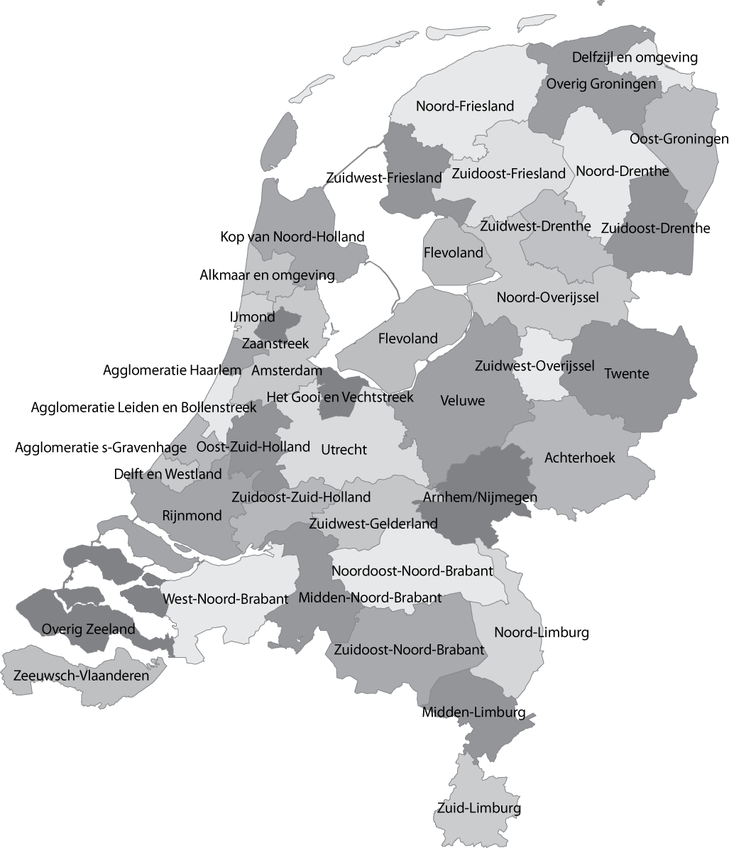
COROP
View on Wikipediafrom Wikipedia

A COROP region is a division of the Netherlands for statistical purposes, used by Statistics Netherlands, among others. The Dutch abbreviation stands for Coördinatiecommissie Regionaal Onderzoeksprogramma (Coordination Commission Regional Research Programme). These divisions are also used in the EU designation as NUTS 3.
List of municipalities by COROP region
[edit]Northern Netherlands
[edit]Groningen province
[edit]| COROP region | Municipalities |
|---|---|
| East Groningen (Oost-Groningen) |
Oldambt, Pekela, Stadskanaal, Veendam, Westerwolde |
| Greater Delfzijl (Delfzijl en omgeving) |
Eemsdelta |
| Rest of Groningen (Overig Groningen) |
Groningen, Het Hogeland, Midden-Groningen, Westerkwartier |
Friesland province
[edit]| COROP region | Municipalities |
|---|---|
| North Friesland (Noord-Friesland) |
Achtkarspelen, Ameland, Dantumadiel, Harlingen, Leeuwarden, Noardeast-Fryslân, Schiermonnikoog, Terschelling, Tietjerksteradeel, Vlieland, Waadhoeke |
| South West Friesland (Zuidwest-Friesland) |
De Fryske Marren, Súdwest-Fryslân |
| South East Friesland (Zuidoost-Friesland) |
Heerenveen, Ooststellingwerf, Opsterland, Smallingerland, Weststellingwerf |
Drenthe province
[edit]| COROP region | Municipalities |
|---|---|
| North Drenthe (Noord-Drenthe) |
Aa en Hunze, Assen, Midden-Drenthe, Noordenveld, Tynaarlo |
| South West Drenthe (Zuidwest-Drenthe) |
Hoogeveen, Meppel, Westerveld, De Wolden |
| South East Drenthe (Zuidoost-Drenthe) |
Borger-Odoorn, Coevorden, Emmen |
Eastern Netherlands
[edit]Overijssel province
[edit]| COROP region | Municipalities |
|---|---|
| North Overijssel (Noord-Overijssel) |
Dalfsen, Hardenberg, Kampen, Ommen, Staphorst, Steenwijkerland, Zwartewaterland, Zwolle |
| South West Overijssel (Zuidwest-Overijssel) |
Deventer, Olst-Wijhe, Raalte |
| Twente | Almelo, Borne, Dinkelland, Enschede, Haaksbergen, Hellendoorn, Hengelo, Hof van Twente, Losser, Oldenzaal, Rijssen-Holten, Tubbergen, Twenterand, Wierden |
Gelderland province
[edit]| COROP region | Municipalities |
|---|---|
| Veluwe | Apeldoorn, Barneveld, Ede, Elburg, Epe, Ermelo, Harderwijk, Hattem, Heerde, Nijkerk, Nunspeet, Oldebroek, Putten, Scherpenzeel, Voorst, Wageningen |
| South West Gelderland (Zuidwest-Gelderland) |
Buren, Culemborg, Maasdriel, Neder-Betuwe, Tiel, West Betuwe, West Maas en Waal, Zaltbommel |
| Achterhoek | Aalten, Berkelland, Bronckhorst, Brummen, Doetinchem, Lochem, Montferland, Oost Gelre, Oude IJsselstreek, Winterswijk, Zutphen |
| Arnhem & Nijmegen | Arnhem, Berg en Dal, Beuningen, Doesburg, Druten, Duiven, Heumen, Lingewaard, Nijmegen, Overbetuwe, Renkum, Rheden, Rozendaal, Westervoort, Wijchen, Zevenaar |
Flevoland province
[edit]| COROP region | Municipalities |
|---|---|
| Flevoland | Almere, Dronten, Lelystad, Noordoostpolder, Urk, Zeewolde |
Western Netherlands
[edit]Utrecht province
[edit]| COROP region | Municipalities |
|---|---|
| Utrecht | Amersfoort, Baarn, De Bilt, Bunnik, Bunschoten, Eemnes, Houten, IJsselstein, Leusden, Lopik, Montfoort, Nieuwegein, Oudewater, Renswoude, Rhenen, De Ronde Venen, Soest, Stichtse Vecht, Utrecht, Utrechtse Heuvelrug, Veenendaal, Vijfheerenlanden, Wijk bij Duurstede, Woerden, Woudenberg, Zeist |
North Holland province
[edit]| COROP region | Municipalities |
|---|---|
| Kop van North Holland (Kop van Noord-Holland) |
Den Helder, Drechterland, Enkhuizen, Hollands Kroon, Hoorn, Koggenland, Medemblik, Opmeer, Schagen, Stede Broec, Texel |
| Alkmaar agglomeration (Alkmaar en omgeving) |
Alkmaar, Bergen, Dijk en Waard, Heiloo, Schermer |
| IJmond | Beverwijk, Castricum, Heemskerk, Uitgeest, Velsen |
| Haarlem agglomeration (Agglomeratie Haarlem) |
Bloemendaal, Haarlem, Heemstede, Zandvoort |
| Zaanstreek | Wormerland, Zaanstad |
| Greater Amsterdam (Groot-Amsterdam) |
Aalsmeer, Amstelveen, Amsterdam, Diemen, Edam-Volendam, Haarlemmermeer, Landsmeer, Oostzaan, Ouder-Amstel, Purmerend, Uithoorn, Waterland |
| Het Gooi & Vechtstreek | Blaricum, Gooise Meren, Hilversum, Huizen, Laren, Weesp, Wijdemeren |
South Holland province
[edit]| COROP region | Municipalities |
|---|---|
| Leiden & Bollenstreek | Hillegom, Kaag en Braassem, Katwijk, Leiden, Leiderdorp, Lisse, Noordwijk, Oegstgeest, Teylingen, Voorschoten, Zoeterwoude |
| Greater The Hague (Agglomeratie 's-Gravenhage) |
The Hague, Leidschendam-Voorburg, Pijnacker-Nootdorp, Rijswijk, Wassenaar, Zoetermeer |
| Delft & Westland | Delft, Midden-Delfland, Westland |
| East South Holland (Oost-Zuid-Holland) |
Alphen aan den Rijn, Bodegraven-Reeuwijk, Gouda, Krimpenerwaard, Nieuwkoop, Waddinxveen |
| Greater Rijnmond | Albrandswaard, Barendrecht, Brielle, Capelle aan den IJssel, Goeree-Overflakkee, Hellevoetsluis, Hoeksche Waard, Krimpen aan den IJssel, Lansingerland, Maassluis, Nissewaard, Ridderkerk, Rotterdam, Schiedam, Vlaardingen, Westvoorne, Zuidplas |
| South East South Holland (Zuidoost-Zuid-Holland) |
Alblasserdam, Dordrecht, Gorinchem, Hardinxveld-Giessendam, Hendrik-Ido-Ambacht, Molenlanden, Papendrecht, Sliedrecht, Zwijndrecht |
Zeeland province
[edit]| COROP region | Municipalities |
|---|---|
| Zeelandic Flanders (Zeeuws-Vlaanderen) | Hulst, Sluis, Terneuzen |
| Rest of Zeeland (Overig Zeeland) | Borsele, Goes, Kapelle, Middelburg, Noord-Beveland, Reimerswaal, Schouwen-Duiveland, Tholen, Veere, Vlissingen |
Southern Netherlands
[edit]North Brabant province
[edit]| COROP region | Municipalities |
|---|---|
| West North Brabant (West-Noord-Brabant) |
Bergen op Zoom, Breda, Drimmelen, Etten-Leur, Geertruidenberg, Halderberge, Moerdijk, Oosterhout, Roosendaal, Rucphen, Steenbergen, Woensdrecht, Zundert |
| Mid North Brabant (Midden-Noord-Brabant) |
Alphen-Chaam, Altena, Baarle-Nassau, Dongen, Gilze en Rijen, Goirle, Hilvarenbeek, Loon op Zand, Oisterwijk, Tilburg, Waalwijk |
| North East North Brabant (Noordoost-Noord-Brabant) |
Bernheze, Boekel, Boxtel, 's-Hertogenbosch, Heusden, Land van Cuijk, Maashorst, Meierijstad, Oss, Sint-Michielsgestel, Vught |
| South East North Brabant (Zuidoost-Noord-Brabant) |
Asten, Bergeijk, Best, Bladel, Cranendonck, Deurne, Eersel, Eindhoven, Geldrop-Mierlo, Gemert-Bakel, Heeze-Leende, Helmond, Laarbeek, Nuenen, Gerwen en Nederwetten, Oirschot, Reusel-De Mierden, Someren, Son en Breugel, Valkenswaard, Veldhoven, Waalre |
Limburg province
[edit]| COROP region | Municipalities |
|---|---|
| North Limburg (Noord-Limburg) |
Beesel, Bergen, Gennep, Horst aan de Maas, Mook en Middelaar, Peel en Maas, Venlo, Venray |
| Mid Limburg (Midden-Limburg) |
Echt-Susteren, Leudal, Maasgouw, Nederweert, Roerdalen, Roermond, Weert |
| South Limburg (Zuid-Limburg) |
Beek, Beekdaelen, Brunssum, Eijsden-Margraten, Gulpen-Wittem, Heerlen, Kerkrade, Landgraaf, Maastricht, Meerssen, Simpelveld, Sittard-Geleen, Stein, Vaals, Valkenburg aan de Geul, Voerendaal |
See also
[edit]COROP
View on Grokipediafrom Grokipedia
A COROP region (from the Dutch Coördinatiecommissie Regionaal Onderzoeksprogramma, or Coordination Commission for Regional Research Programme) is a statistical subdivision of the Netherlands consisting of one or more contiguous municipalities within a single province, designed primarily for regional analysis and planning purposes.[1][2] Established around 1970 by an interdepartmental commission to facilitate coordinated regional research and policy development, the system divides the country into exactly 40 such regions, providing a granular level of geographic detail between the broader provincial level and individual municipalities.[2][3]
These regions serve as the Dutch equivalent of the European Union's NUTS 3 (Nomenclature of Territorial Units for Statistics) level, enabling standardized comparisons of socioeconomic indicators such as population, employment, and economic output across Europe.[1][4] Primarily utilized by Statistics Netherlands (Centraal Bureau voor de Statistiek, or CBS) for data collection, dissemination, and analysis, COROP regions support government planning, economic forecasting, and academic research by aggregating municipal data into cohesive territorial units that reflect functional economic and social linkages.[1][5] While the boundaries have remained largely stable since their inception—with occasional adjustments for administrative changes such as municipal mergers—the framework continues to underpin key national datasets, including regional GDP, labor market statistics, and environmental metrics as of 2024.[6][4]
Overview
Definition and Etymology
COROP refers to a system of regional divisions in the Netherlands designed for statistical purposes, grouping the country into 40 contiguous areas composed of one or more municipalities.[1] These regions cover the entire territory of the Netherlands without overlap, providing a framework for aggregating and analyzing data at a sub-provincial level.[7] The acronym COROP derives from the Dutch "Coördinatiecommissie Regionaal Onderzoeksprogramma," which translates to Coordination Committee for Regional Research Program.[7] This committee, established in the 1970s, developed the division primarily on statistical grounds to facilitate regional economic analysis and research.[7] The system's name thus originates directly from this body, reflecting its origins in coordinated efforts to study and report on regional disparities and developments across the country.[7] Statistics Netherlands (CBS) utilizes the COROP framework for compiling and disseminating regional statistics, ensuring consistent data aggregation across these municipal groupings.[1]Purpose and Applications
The primary purpose of COROP regions is to enable the collection and analysis of economic and social statistics at a sub-provincial scale, providing more granular insights than province-level data to support balanced regional policy-making across the Netherlands.[1] This framework allows policymakers to identify and address disparities in development, resource allocation, and socio-economic trends within smaller, contiguous groups of municipalities.[1] Statistics Netherlands (CBS) applies COROP regions extensively to compile and disseminate data on critical indicators, including employment, income distribution, housing availability, and demographic shifts, all at this intermediate regional level.[8] For example, CBS uses these regions to track annual changes in residential construction, facilitating targeted interventions in areas with varying growth patterns.[8] In government planning, COROP data informs the distribution of regional development funds, infrastructure investments, and environmental monitoring initiatives, such as assessing land-use pressures and urban expansion needs. COROP regions also play a key role in academic research, where they serve as units for examining regional disparities, including urban versus rural trends in productivity and economic specialization.[9] For instance, studies leverage CBS-derived COROP datasets to analyze intra-regional wage inequalities and industrial diversification.[10] Additionally, as the Dutch equivalent to the European Union's NUTS 3 classification, COROP data supports EU cohesion policy programs for regional aid and contributes to national budget allocations by highlighting eligible areas for funding.[11]History
Establishment in 1970
The Coördinatiecommissie Regionaal Onderzoeksprogramma (COROP), under the auspices of the Dutch Ministry of Economic Affairs, was established in 1970 to coordinate and facilitate regional research initiatives aimed at informing economic policy.[12] This committee developed a standardized framework for analyzing regional disparities, building on the Netherlands' long-standing statistical traditions that dated back to the 19th century with the founding of what would become Statistics Netherlands (CBS) in 1899.[7] The primary rationale for creating the COROP system stemmed from the need for more granular regional data to tackle persistent post-war economic imbalances, which had concentrated growth in urban centers while peripheral areas lagged in industrial development and employment opportunities.[13] In the context of emerging decentralization policies, the system enabled better-targeted interventions to promote balanced regional growth, labor mobility, and resource allocation across the country.[14] Statistics Netherlands played a pivotal role in this process, collaborating with the committee to delineate boundaries that respected existing administrative units while prioritizing functional economic ties.[7] The initial division partitioned the Netherlands into 40 contiguous regions, designed for economic homogeneity through a nodal principle that grouped municipalities around central cities based on commuting patterns, population density, and shared labor markets.[12] This structure ensured regions were practical for data collection and analysis, avoiding overly fragmented units while capturing intra-provincial variations essential for policy planning. For instance, urban agglomerations like Amsterdam and Rotterdam were defined to reflect their dominant economic roles, whereas rural areas in the north and south were clustered to highlight their distinct challenges.[2] The COROP framework saw its first official applications in the 1970s through regional economic reports produced by Statistics Netherlands, which supported industrial growth strategies and labor market assessments by providing localized metrics on employment, value added, and infrastructure needs.[7] These reports informed key policy decisions, such as investments in underdeveloped regions to mitigate unemployment and foster equitable development across the nation.[14]Evolution and Updates
Since its establishment in 1970, the COROP system has maintained a stable structure of 40 regions, with updates primarily consisting of adjustments to regional compositions following municipal mergers that cross existing boundaries. These changes ensure the preservation of the nodal principle, which groups municipalities around central economic and urban nodes, while adapting to evolving administrative landscapes. The Central Bureau of Statistics (CBS) conducts these bijstellingen (adjustments) to uphold statistical consistency across regions.[7] In the 1980s and 1990s, waves of municipal mergers—driven by efforts to enhance administrative efficiency—necessitated several such adjustments, particularly in densely populated urban areas like the Randstad. For instance, mergers in regions around Amsterdam and Rotterdam led to reassignments of municipalities to maintain coherent statistical units, reflecting demographic shifts and urban expansion without altering the overall number of COROP regions. These revisions helped accommodate the reduction in the total number of municipalities from over 800 in the early 1980s to around 500 by the late 1990s.[2][15] The 2000s saw continued incorporation of new or merged municipalities into the existing framework amid further administrative reforms, ensuring the 40 regions remained intact while updating internal compositions. A notable adaptation occurred in 1986 with the creation of Flevoland province from reclaimed land, integrating it as a dedicated COROP region to align with the new provincial boundaries and support regional economic analysis. By the 2010s, updates addressed challenges from decentralization policies that devolved more responsibilities to municipalities, balancing the need for consistent statistical reporting with local governance evolution.[16][7] As of 2025, the CBS continues to refine the COROP indeling through annual publications, incorporating recent municipal changes to reflect population growth and ensure compatibility with EU NUTS 3 classifications. These ongoing tweaks, particularly in dynamic areas like North Holland and Flevoland, enhance data precision for analyzing migration and housing dynamics, thereby supporting evidence-based regional policy.[4][17]Administrative and Statistical Context
Relation to Provinces
The Netherlands is divided into 12 provinces, each of which contains between 1 and 7 COROP regions, for a national total of 40 such regions. For example, Flevoland and Utrecht each comprise a single COROP region, North Holland includes 7, while Drenthe comprises 3. These regions function as sub-provincial units, grouping one or more contiguous municipalities strictly within provincial boundaries to facilitate granular statistical analysis.[18] Provinces operate as political and administrative entities, each governed by a directly elected provincial council (Provinciale Staten) that sets policy priorities, supervises the executive, and manages regional affairs such as spatial planning and environmental regulation. In distinction, COROP regions hold no administrative or governing powers; they exist solely as a statistical framework established by Statistics Netherlands (CBS) for economic and demographic data compilation, without elected bodies or decision-making authority. COROP boundaries adhere to provincial limits but enable flexible groupings of municipalities across local lines to better capture economic interdependencies and functional urban areas, enhancing the representation of regional dynamics like labor markets and trade flows. This design supports targeted statistical reporting on issues such as productivity and migration within provinces. In South Holland, for instance, the province's 5 COROP regions—such as Rijnmond (encompassing Rotterdam) and Agglomeratie 's-Gravenhage (centered on The Hague)—highlight dense urban clusters that transcend simple municipal divisions, allowing data to reflect metropolitan economic hubs more accurately. The system's advantages include seamless aggregation of COROP-level statistics to provincial scales for national overviews and EU submissions, preserving regional detail while ensuring consistency in reporting frameworks like the NUTS classification.Alignment with NUTS Classification
The COROP classification serves as the Dutch implementation of the European Union's Nomenclature of Territorial Units for Statistics (NUTS) at level 3, comprising 40 regions designed to meet EU requirements for sub-regional statistical data collection and analysis.[1] In this framework, the Netherlands is divided into four NUTS 1 regions (the major landsdelen: Noord-Nederland, Oost-Nederland, West-Nederland, and Zuid-Nederland) and 12 NUTS 2 regions corresponding to the provinces, providing a hierarchical structure that aligns national divisions with EU-wide comparability. The alignment of COROP regions with NUTS 3 is maintained by Statistics Netherlands (CBS) in close coordination with Eurostat, involving periodic reviews to ensure territorial contiguity, socioeconomic coherence, and adherence to population thresholds typically ranging from 150,000 to 800,000 inhabitants per region.[19] These reviews follow the stability principle established in EU regulations, allowing adjustments only under specific conditions such as significant demographic shifts or administrative boundary changes to preserve data consistency across reporting periods.[20] COROP data at the NUTS 3 level directly supports EU reporting obligations, particularly for structural and cohesion funds allocation, where regional indicators on economic performance, employment, and development inform eligibility and funding distribution to reduce disparities among member states.[21] This integration facilitates comparative studies across the EU, enabling policymakers to benchmark Dutch regions against equivalents in other countries for initiatives like the European Regional Development Fund. In contrast to administrative divisions such as Germany's Kreise (districts, which serve both statistical and local governance functions with a strong emphasis on public administration) or France's arrondissements (sub-prefectural units focused on electoral and judicial oversight), COROP regions emphasize economic and functional logic over strict administrative boundaries to better capture labor market and industry patterns.[1] This statistical orientation allows for more flexible groupings of municipalities tailored to economic analysis rather than rigid governance structures. Following the 2003 NUTS regulation, which formalized population thresholds and review mechanisms, the Netherlands undertook revisions in the 2010s—including the 2010 and 2013 updates—to enhance compliance with Eurostat criteria, ensuring COROP boundaries remained suitable for evolving EU data needs without major structural alterations.[22]Regional Divisions
Northern Netherlands
The Northern Netherlands comprises the provinces of Groningen, Friesland, and Drenthe, which together form nine COROP regions used for regional statistical reporting and analysis. These regions facilitate data aggregation on demographics, economy, and labor markets within the broader Northern Netherlands landsdelen (major statistical area). The area is characterized by its predominantly rural landscape, with economic activities centered on agriculture—particularly dairy farming and crop production—energy extraction from the Groningen gas field, and tourism drawn to coastal wetlands, historical sites, and natural reserves. The total population across these provinces stands at approximately 1.77 million as of 2024.[1]Groningen Province
Groningen province is subdivided into three COROP regions, reflecting its mix of urban centers and rural expanses influenced by the historic Groningen gas field, one of Europe's largest natural gas reserves discovered in 1959.- East Groningen (Oost-Groningen): This region encompasses the municipalities of Oldambt, Pekela, Stadskanaal, Veendam, and Westerwolde, focusing on agricultural activities in peat and clay soils.
- Greater Delfzijl (Delfzijl en omgeving): Comprising Eemsdelta (formed by the 2021 merger of Appingedam, Delfzijl, and Loppersum), it features port-related industries and energy infrastructure near the Ems estuary.
- Rest of Groningen (Overig Groningen): This includes the city of Groningen and surrounding municipalities such as Het Hogeland, Midden-Groningen, and Westerkwartier, serving as the provincial hub with higher population density and service sectors.
Friesland Province
Friesland province, known for its Frisian cultural heritage and island-dotted Wadden Sea coast (a UNESCO World Heritage site boosting tourism), is divided into three COROP regions emphasizing rural and water-based economies.- North Friesland (Noord-Friesland): Covering northern and central areas, it includes municipalities like Achtkarspelen, Ameland, Dantumadiel, Harlingen, Leeuwarden, Noardeast-Fryslân, Schiermonnikoog, Terschelling, Tytsjerksteradiel (merged into Noardeast-Fryslân), Vlieland, and Waadhoeke (incorporating former central rural zones such as Franekeradiel), with a focus on dairy farming and eco-tourism.
- Southwest Friesland (Zuidwest-Friesland): This region includes De Fryske Marren and Súdwest-Fryslân (home to Sneek), characterized by lake districts supporting water sports and agriculture.
- Southeast Friesland (Zuidoost-Friesland): Encompassing Heerenveen, Ooststellingwerf, Opsterland, Smallingerland, and Weststellingwerf, it features forested areas and intensive farming.
Drenthe Province
Drenthe province, with its prehistoric hunebeds and heathlands promoting outdoor tourism, consists of three COROP regions largely rural and geared toward sustainable agriculture and nature conservation.- North Drenthe (Noord-Drenthe): Including Aa en Hunze, Assen, Midden-Drenthe, Noordenveld, and Tynaarlo, it centers on the provincial capital Assen and mixed farming landscapes.
- East Drenthe (Zuidoost-Drenthe): This covers Borger-Odoorn, Coevorden, and Emmen, known for industrial edges alongside agricultural peat reclamation.
- Southwest Drenthe (Zuidwest-Drenthe): Comprising De Wolden, Hoogeveen, Meppel, and Westerveld, it highlights riverine areas with dairy production and recreational boating.