Recent from talks
Nothing was collected or created yet.
Oosterhout
View on Wikipedia
Key Information
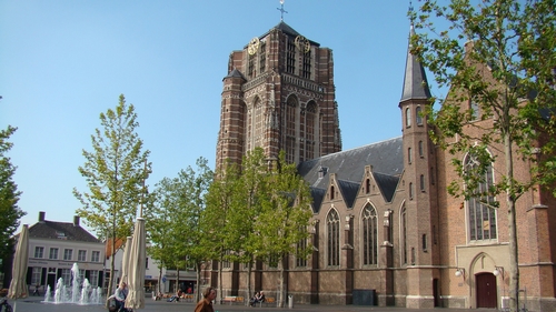
Oosterhout (Dutch pronunciation: [ˈoːstərɦʌut] ⓘ; from ooster, "eastern", and hout, "woods") is a municipality and a city in southern Netherlands. The municipality had a population of 56,206 in 2021.
Population centers
[edit]The municipality of Oosterhout includes the following places:
History
[edit]Oosterhout is mentioned for the first time in 1277, although archaeological excavations showed the existence of human settlements in the area in prehistoric times. The Knights Templar had a temple here dedicated to St. John the Baptist. It was home to a castle which later acquired control over the surrounding area, up to Breda and Bergen op Zoom. The castle was destroyed by Spanish troops during the Eighty Years War, in 1573; only a tower of it survives today.
The city became the seat of a flourishing ceramics industry, which lasted until the 19th century. In 1625 the city was besieged by Frederick Henry, Prince of Orange, and suffered heavy damage.
Despite the rise of Protestantism, it was home to several Catholic monasteries, including that of the Premonstratensians, which is still active. Oosterhout received city rights in 1809, by will of Louis Bonaparte.
Main sights
[edit]- Slotjes (Castle)
- Unfinished basilica of St. John. A Romanesque church existed in 1277, but from around 1473 it was rebuilt in the current Gothic style, being finished in 1493. The tower was constructed from 1519 to 1552. It has been restored several times in the following centuries.
- Monastery of St. Catherine, once a castle held by the Knights Hospitaller.
- Slotbossetoren, destroyed castle
Culture
[edit]De anoniemen, a group of statues created by Paul Elshout, is situated in Slotpark.
Sport
[edit]Oosterhout is home to several sports clubs, for example volleyball club VOKO, football clubs SCO-Tofs, VV Oosterhout, baseball club Twins and hockey club De Warande.
Sport clubs
[edit]- VOKO, Volleyball
- ATV Scorpio, Athletics
- SCO-Tofs, Football
- TSC, Football
- VV Oosterhout, Football
- De Warande, Hockey
- OZ&PC De Warande, Swimming and Water polo
- De Voltreffers, Korfball
- De Glaskoning Twins, Baseball
Notable people
[edit]
- Willem Hendrik de Vriese (1806–1862) a Dutch botanist and physician
- Christiaan Snouck Hurgronje (1857–1936) a Dutch scholar of Oriental cultures and Advisor to the colonial government of the Netherlands East Indies
- Marinus De Jong (1891-1984) a Belgian composer and pianist of Dutch origin
- Gerrit Brokx (1933–2002) a Dutch politician
- Johannes Wilhelmus Maria Liesen (born 1960) a Dutch clergyman and bishop of the Roman Catholic Diocese of Breda
- Mirjam Mous (born 1963) a Dutch author of children's literature
- Marlies Dekkers (born 1965) a Dutch fashion designer
- Peter Kops (born 1967) known as Extince, a Dutch rapper
- Sander P. Zwegers (born 1975) a Dutch mathematician and academic
Sport
[edit]
- Kees Pijl (1897–1976) a Dutch footballer with 203 caps for Feyenoord, competed in the 1924 Summer Olympics
- Wanny van Gils (1959–2018) a Dutch football player with over 300 club caps and coach
- Kelly van Zon (born 1987) a Dutch table tennis player
- Wesley Vissers (born 1993) a Dutch professional bodybuilder
- Jennifer Vreugdenhil (born 1995) a Dutch footballer
Gallery
[edit]References
[edit]- ^ "Burgemeester mr. drs. S.W.Th. Huisman" (in Dutch). Gemeente Oosterhout. Archived from the original on 2 April 2016. Retrieved 2 June 2014.
- ^ "Kerncijfers wijken en buurten 2020" [Key figures for neighbourhoods 2020]. StatLine (in Dutch). CBS. 24 July 2020. Retrieved 19 September 2020.
- ^ "Postcodetool for 4902ZP". Actueel Hoogtebestand Nederland (in Dutch). Het Waterschapshuis. Archived from the original on 26 December 2018. Retrieved 2 June 2014.
- ^ "Bevolkingsontwikkeling; regio per maand" [Population growth; regions per month]. CBS Statline (in Dutch). CBS. 1 January 2021. Retrieved 2 January 2022.
External links
[edit]
Media related to Oosterhout, North Brabant at Wikimedia Commons- Official website
Oosterhout
View on GrokipediaOosterhout is a municipality and city in the province of North Brabant in the southern Netherlands.[1]
The area covers approximately 17 square kilometers in the core urban zone and supports a population of 58,380 as of 2025 estimates.[1][2]
Historical records first mention Oosterhout in 1277, though archaeological evidence indicates prehistoric human settlements in the region, and it received official city rights in 1809.[3][4]
Key defining features include its preserved historic center with Gothic architecture, such as the Sint Jansbasiliek basilica and the ruins of Strijen Castle, alongside modern industrial development hosting manufacturing firms in sectors like steel, packaging, and chemicals.[5][6][7]
The municipality balances cultural heritage preservation, evident in sites like the Brabants Museum Oud Oosterhout, with economic activities in logistics and advanced manufacturing that contribute to regional employment and sustainability initiatives.[8][7]
Geography
Location and topography
Oosterhout is situated in the province of North Brabant in the southern Netherlands, with geographical coordinates approximately 51°39′N 4°52′E.[9] The municipality lies about 10 kilometers southeast of Breda and roughly 41 kilometers south of Rotterdam, positioning it within the densely populated western part of the province.[10] The topography of Oosterhout consists of flat, low-lying terrain characteristic of the Dutch coastal plain, with an average elevation of 4 meters above sea level.[11] The area encompasses reclaimed polders and is influenced by nearby waterways, including the Mark River, which borders the region to the north and forms part of the local hydrological system before joining the Dintel.[12] Regional connectivity is enhanced by the A27 motorway, which runs adjacent to the municipality linking it northward toward Utrecht, and the A58, providing eastern access to Eindhoven and western ties to Zeeland ports.[13] The municipality covers 73.09 square kilometers, featuring a mix of built-up urban zones amid agricultural lands and green polders that reflect ongoing expansion into peripheral rural areas.[14]Climate and environment
Oosterhout experiences a temperate maritime climate typical of inland southern Netherlands, with mild winters and cool summers moderated by proximity to the North Sea. Average temperatures vary from a low of 0.6°C (33°F) in January to a high of 22.8°C (73°F) in July, rarely falling below -6.7°C (20°F) or exceeding 29°C (84°F).[15] Annual precipitation averages 846 mm, occurring on approximately 149 days with rainfall exceeding 1 mm, distributed relatively evenly across seasons and contributing to lush vegetation but occasional waterlogging in low-lying areas.[16] Environmental challenges stem primarily from the region's delta geography in the Rhine-Meuse basin, where fluvial flooding from river overflow poses risks during heavy rainfall or upstream surges, though probabilities remain low due to engineered defenses like dikes and polders managed under national policy.[17] Oosterhout's topography, situated on slightly elevated sandy soils rather than reclaimed polders, limits direct exposure to sea level rise compared to coastal zones, with flood maps indicating potential inundation only under extreme scenarios exceeding current protections.[18] Local authorities participate in broader Dutch flood risk management, emphasizing resilient infrastructure over reactive measures.[19] Biodiversity is preserved in areas like the Vrachelse Heide, a 150-hectare heathland reserve featuring acidic soils that support specialized flora such as heather and grasses, alongside fauna including birds and insects adapted to open landscapes.[20] These habitats contribute to regional ecological connectivity within North Brabant's network of nature areas, though urban expansion pressures necessitate ongoing conservation to counter habitat fragmentation.[21]History
Early settlements and medieval origins
Archaeological excavations in Oosterhout have uncovered evidence of continuous human settlement from the Bronze Age through the early medieval period, including domestic structures and ritual deposits. Sites reveal Bronze Age activity alongside Iron Age cremation burials, often in miniature urns suggesting selective "pars pro toto" practices where only parts of remains were interred, indicative of localized community rituals rather than full cemetery use.[22][23] Nearby Roman infrastructure, such as a military road and canal, points to connectivity with broader provincial networks by the 1st-3rd centuries AD, facilitating early trade and settlement continuity in the region.[24] The first documented reference to Oosterhout as a parish appears in a June 1277 charter concerning a grant of wasteland, confirming an established ecclesiastical community by the late 13th century.[25] A Romanesque church, dedicated initially to the Holy Spirit among other altars, existed at this time, serving as a focal point for local agrarian populations and marking the transition from scattered prehistoric hamlets to a organized medieval village.[26] This development correlated with modest population growth, driven by fertile Brabantine soils and proximity to trade routes linking the Rhine delta to inland areas. As a dependency within the Barony of Breda, Oosterhout fell under feudal oversight of the Lords of Breda from the 12th century onward, who held regional authority granted by the Dukes of Brabant around 1350. The establishment of the Norbertine convent of Sint-Catharinadal around 1275, initially as a small community of canonesses under Premonstratensian rule, enhanced spiritual and economic ties, with the abbey managing lands and contributing to regional stability through monastic agriculture and charity.[27] These institutions supported gradual expansion without major fortifications, relying instead on baronial protection amid feudal obligations.[28]Early modern period and industrialization
In the early modern period, Oosterhout, situated in the contested borderlands of the Eighty Years' War, faced military pressures as Dutch forces targeted Spanish-held territories in Brabant. During the 1624–1625 siege of nearby Breda by Spanish commander Ambrogio Spinola, Dutch troops under Prince Frederick Henry burned Oosterhout's church to deny resources to the enemy and disrupt supply lines, highlighting the town's strategic vulnerability along trade routes.[29] The 1648 Peace of Westphalia incorporated North Brabant, including Oosterhout, into the Dutch Republic as Generality Lands, where Catholic institutions persisted despite Protestant dominance in the north; Oosterhout retained its role as a Catholic enclave, with religious orders like the Norbertines at St. Peter's Abbey maintaining influence amid limited Reformation enforcement.[30] Economic activity shifted gradually from agrarian dominance toward craft-based production, bolstered by local resources and infrastructure. The abundance of suitable clay deposits spurred a pottery industry in the early 17th century, evolving into one of the Netherlands' largest centers with up to 40 potteries exporting coarse earthenware across Europe via riverine trade networks; this sector thrived on domestic leem (loam) extraction and manual firing techniques until competition from mechanized production in the 19th century eroded its viability.[31] Small harbors along the Mark and Donge rivers facilitated commerce, connecting Oosterhout to Brabant trade routes and mitigating flood risks from recurrent 16th- and 17th-century dike breaches that formed local features like the Verburgtskolk.[32] Proto-industrialization emerged in the 18th and 19th centuries through manufactories and cottage industries, marking a transition from rural self-sufficiency. Home-based production and small workshops in pottery and related crafts drew rural migrants, though growth remained modest due to the region's peripheral status; agricultural price fluctuations after 1740 supported surplus for non-farm ventures, but overall expansion was constrained until infrastructural improvements.[33] By the mid-19th century, Oosterhout saw initial modern facilities, including a gasworks established in 1860 for street lighting and a billiard ball factory in 1870, signaling early adoption of steam power and urban expansion amid broader Brabantian shifts, though full industrialization lagged behind northern provinces.[34] Population records indicate steady influx from surrounding countryside, with the town elevated to city status in 1809 by Louis Napoleon, enhancing administrative capacity for economic coordination.[33]World War II and post-war reconstruction
Oosterhout came under German occupation on May 10, 1940, following the rapid invasion of the Netherlands, with local impacts including the requisitioning of buildings for military use, such as the establishment of a German military hospital at the Catholic St. Joseph Foundation.[35] The occupation enforced rationing, forced labor drafts, and anti-Jewish measures aligned with national policies, though specific deportations from Oosterhout's small Jewish community mirrored broader Dutch patterns of high compliance rates due to administrative efficiency. Local resistance emerged modestly, focusing on intelligence gathering, sabotage, and aiding downed Allied airmen through escape networks; notable figures included Father Jacques Kerssemakers, a priest commemorated for his underground activities.[36] The area saw intensified conflict in September 1944 amid the Allied push following Operation Market Garden, with U.S. 82nd Airborne Division elements engaging German positions near Oosterhout, resulting in actions like Private John R. Towle's Medal of Honor for suppressing enemy fire on September 21. Heavy fighting escalated in late October during Operation Pheasant, as British and Canadian forces advanced against entrenched German units, including the 85th Volksgrenadier Division; Oosterhout was liberated on October 30, 1944, after Germans demolished the Mark River bridge but failed to halt the advance over debris.[37] [38] [39] The battles caused localized damage from artillery shelling, including to the Heuvel district on October 31, though Oosterhout avoided the total devastation seen in northern cities like Arnhem. Casualty figures remain imprecise locally, but national estimates indicate around 20,000 Dutch civilian deaths from occupation hardships, with military losses in Brabant operations numbering in the hundreds for both sides. Post-liberation reconstruction addressed war damage and acute housing shortages exacerbated by national population pressures and returning displaced persons; Oosterhout, like much of North Brabant, prioritized emergency prefab dwellings and infrastructure repairs amid a country-wide deficit of over 300,000 units by 1945. Economic recovery drew on the Marshall Plan, through which the Netherlands received approximately $1.1 billion in U.S. aid from 1948 to 1952, funding industrial revival and housing projects that spurred local growth, including expanded manufacturing and demographic influx from rural migration.[40] By the early 1950s, these efforts stabilized the municipality, with population rising from about 25,000 in 1947 to over 30,000 by 1960, reflecting broader Dutch post-war urbanization without significant ethnic shifts beyond returning expatriates.[41]Contemporary developments
Following World War II reconstruction, Oosterhout underwent significant suburban expansion driven by national population growth and migration from urban centers, transforming it from a primarily agricultural and small-town economy into a commuter-oriented municipality with increased residential developments.[web:8] By the late 20th century, the town's population rose steadily, reaching approximately 57,000 residents by 2020, fueled by its location in North Brabant's economic corridor, which facilitated commuting to nearby cities like Breda and Tilburg via highways A27 and A59, though the absence of a dedicated rail station limited direct integration into broader networks like the Randstad belt.[web:62] This growth pattern reflected broader Dutch post-war urban planning priorities emphasizing housing construction amid housing demand surges, yet Oosterhout's peripheral position constrained faster infrastructure upgrades, such as proposed rail connections that remain unrealized.[web:30] In the 21st century, Oosterhout faced urban planning challenges amid the Netherlands' nationwide housing shortage, estimated at over 400,000 units in 2025, which exacerbated local pressures on affordable housing and land use in expanding suburbs.[web:47] Municipal efforts to address density included zoning for new residential zones, but national constraints like nitrogen emissions regulations and grid capacity limits have delayed projects, mirroring delays in building up to 500,000 planned homes across the country.[web:41] Incidents of social tension, such as antisemitic graffiti at the local Jewish cemetery reported in 2015, highlighted occasional vulnerabilities in community cohesion, though such events were isolated within North Brabant's context of rising national antisemitic reports.[web:53] Notable political and criminal events underscored governance strains: in January 2018, Mayor Jan Gnirrep resigned after five women alleged sexual harassment, prompting an investigation that exposed lapses in municipal oversight.[web:10] More recently, on March 28, 2025, a shooting in a residential area killed two 32-year-old local men immediately and a third victim later from injuries, with the family of one deceased suspecting mistaken identity in what police investigations linked to organized crime, leading to the June 2025 arrests of three Swedish nationals in Sweden and Germany suspected as hitmen; the motive remains undetermined as of October 2025.[web:20][web:21][web:24][web:28] These incidents reflect causal factors like proximity to regional criminal networks in Brabant, contributing to heightened security measures without evidence of broader suburban decline.Demographics
Population statistics and trends
As of 1 January 2025, the municipality of Oosterhout had a preliminary population of 58,381 inhabitants, according to municipal records aligned with Centraal Bureau voor de Statistiek (CBS) data.[42] This figure reflects ongoing annual updates from CBS registrations of births, deaths, and migrations. The land area of 71.43 km² yields a population density of approximately 817 inhabitants per km².[1] Historical trends indicate steady growth, with the population rising from 50,642 in 1995 to 58,380 in 2025—an increase of 7,738 residents, or about 15% over three decades.[43] Key milestones include 54,018 inhabitants in 2016 and 56,206 in 2021, driven by net positive internal and international migration exceeding natural population change.[44] [45]| Year | Population |
|---|---|
| 1995 | 50,642 [43] |
| 2016 | 54,018 [44] |
| 2021 | 56,206 [1] |
| 2025 | 58,380 [43] |
