
Community hub
Recent from talks
Contribute something
Nothing was collected or created yet.
Kanara
View on Wikipedia
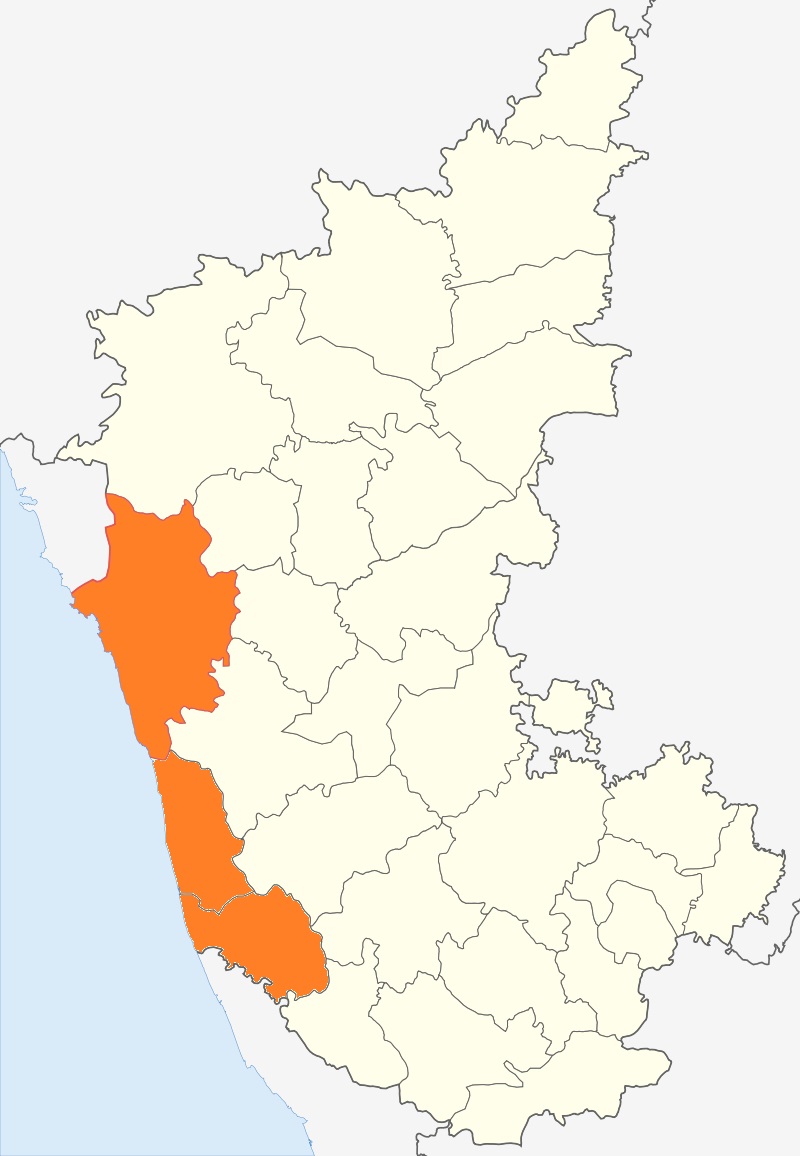
Canara, also known as Karāvali, is the historically significant stretch of land situated by the southwestern Konkan coast of India, alongside the Arabian Sea in the present-day Indian state of Karnataka.[1] The subregion comprises three civil districts, namely: Uttara Kannada, Udupi, and Dakshina Kannada.[2] Kasaragod was included prior to the States Reorganisation Act.
Key Information


Etymology
[edit]According to historian Severino da Silva, the ancient name for this region is Parashurama Srushti (creation of Parashurama).[3] According to him and Stephen Fuchs, the name Canara is the invention of Portuguese, Dutch, and English people who visited the area for trade from the early sixteenth century onwards. The Bednore Dynasty, under whose rule this tract was at that time, was known to them as the Kannada Dynasty, i.e., the dynasty speaking the Kannada language. "Karāvalli", the Kannada word for 'coast', is the term used by Kannada-speakers to refer to this region.[4] The letter 'd' being always pronounced like 'r' by the Europeans, the district was named by them as 'Canara' (a corruption of the word "Kannada"). This name was retained by the British after their occupation of the district in 1799, and has remained ever since. However, they also say that this issue is controversial.[4]
History
[edit]Since antiquity, much of the Canara coast occupied a culturally distinct area known as Tulu Nadu.[5] Historically, Tulu Nadu lay between the Gangavalli River in the north and the Chandragiri River in the south.[6] Currently, Tulu Nadu consists of the Udupi and Dakshina Kannada districts of Karnataka, and the Manjeshwaram taluk of Kerala.[7] The Uttara Kannada district in general is considered to be the southernmost part of the Konkan coast.[8] Specifically, the littoral region north of the Gangavalli River is traditionally included in the Konkan.[9]
The Portuguese occupied Kanara from 1498–1763. During this period, the geographical extent of Canara stretched from the southern banks of the Kali River in Karwar in the north to the northern banks of the Chandragiri River in Kasaragod in the south.[10]
In 1799, after the conclusion of the Fourth Mysore War, the British took over the region and established the Canara district of the Madras Presidency. The district was bifurcated into the North and South Canara districts in 1859.[11] The North Canara district was transferred to the Bombay Presidency whereas the South Canara district remained under the jurisdiction of the Madras Presidency. South Canara encompassed the undivided territory of the contemporary Udupi, Dakshina Kannada, and Kasaragod districts.[11]
After India's independence in 1947, the Bombay Presidency was reconstituted as the Bombay State. Following the States Reorganisation Act, 1956, the southern portion of Bombay State was added to Mysore State, which was renamed Karnataka in 1972. Kasaragod was included in Kerala.[12] Subsequently, North and South Canara were renamed Uttara Kannada and Dakshina Kannada respectively. In 1997, Udupi district was carved out of the bigger Dakshina Kannada district.[12]
Geography
[edit]The Kanara region forms the coast of Karnataka situated on the south-western portion of Peninsular India.[13] Coastal Karnataka forms the northern segment of the Malabar coast.[14] Kanara constitutes an area of about 10,000 square kilometres (4,000 square miles).[15] It is bounded by Konkan to the north, the Western Ghats to the east, the Kerala Plains to the south, and the Arabian Sea to the west.[16] It stretches from north to south for about 225 kilometres (140 miles) and has a maximum width of about 64 kilometres (40 miles) in the south.[17]
Civil administration
[edit]Contemporary Kanara extends from the village of Majali in the north to the village of Talapady in the south.[10] The three districts in the region: Uttara Kannada, Udupi, and Dakshina Kannada have their capitals in Karwar, Udupi, and Mangalore respectively.[18]
Demographics
[edit]- Hinduism (76.5%)
- Islam (16.4%)
- Christianity (5.90%)
- Others (1.19%)
The Kanara region have 3 Districts: Uttara Kannada, Udupi, and Dakshina Kannada. The combined population of these districts, according to the 2011 Census is about 47,04,179 .
Languages
[edit]- Kannada (31.7%)
- Tulu (29.4%)
- Konkani (13.0%)
- Beary (7.64%)
- Malayalam (4.96%)
- Marathi (3.62%)
- Others (9.64%)
The main languages that are closely associated with the Kanara region are Kannada, Konkani and Tulu.
See also
[edit]Notes
[edit]^A Konkan is now held to include all the land which lies between the Western Ghats and the Indian Ocean, from the latitude of Daman on the north to that of Terekhol, on the Goa frontier, on the south.[19] Although most sources generally assign Kanara (Karavali) to the Malabar Coast,[15] some other sources consider it to be a subterritory of the Konkan Coast.[20] Consequently, this segment is thought to overlap the Konkan and Malabar Coast continuum;[16] and usually corresponds to the southernmost and northernmost stretches of these locales respectively.[21][17]
Citations
[edit]- ^
Arnold, Alison, ed. (2017). "Coastal Karnataka". The Garland Encyclopedia of World Music: South Asia: The Indian Subcontinent. Routledge. ISBN 9781351544382.
Coastal Karnataka, formerly called the Canara Coast, is the part of Indias southwestern coastline north of Kerala and south of Goa. [sic]
- ^
K., Prakashnarayana (2018). "Geography of Karnataka". Know Our Karnataka: A book for Competitive Exams. pp. 27–36.
Popularly known as Canara region or Karavali...
- ^ Silva 1958, p. 74
- ^ a b Silva & Fuchs 1965, pp. 1§2
- ^ "This city has six names in six languages, and the official one Mangaluru, is the least popular". The News Minute. 6 November 2014. Archived from the original on 8 April 2019. Retrieved 15 September 2019.
- ^ Bhatt, P. Gururaja (1969). Antiquities of South Kanara. Prabhakara Press. p. 2.
- ^ "Tulu Nadu Region". keralatourism.org. Government of Kerala. Retrieved 15 September 2018.
- ^ Charlesworth, Neil (2001). Peasants and Imperial Rule: Agriculture and Agrarian Society in the Bombay Presidency 1850–1935. Cambridge South Asian Studies. Vol. 32 (revised ed.). CUP. p. 60. ISBN 9780521526401.
- ^ Memorandum on Maharashtra-Mysore border dispute to the Commission on Maharashtra-Mysore-Kerala boundary disputes. 1967. Government of Maharashtra. p. 59.
- ^ a b Shastry, Bhagamandala Seetharama (2000). Borges, Charles J. (ed.). Goa-Kanara Portuguese Relations, 1498–1763. XCHR studies series. Vol. 8. Concept Publishing Company. ISBN 9788170228486.
- ^ a b "Chapter 3 – Profile of the Study Area: Coastal Karnataka" (PDF). Shodhganga. Retrieved 15 September 2019.
- ^ a b Bhat, N. Shyam (1998). South Kanara, 1799–1860: A Study in Colonial Administration and Regional Response. Mittal Publications. ISBN 9788170995869.
- ^ "India: Coastal areas". Encyclopædia Britannica Online. Encyclopædia Britannica, Inc. 16 October 2019. Retrieved 19 October 2019.
From Goa south to Cape Comorin (the southernmost tip of India) is the Malabar coastal plain...
- ^
Goldberg, Maren (ed.). "Malabar Coast". Encyclopædia Britannica Online. Encyclopædia Britannica, Inc. Retrieved 19 September 2019.
Malabar Coast...the southern part of India's western coast, approximately from the state of Goa southward...
- ^ a b
Pletcher, Kenneth (ed.). "Kanara". Encyclopædia Britannica Online. Encyclopædia Britannica, Inc. Retrieved 19 September 2019.
Kanara, region along the Malabar Coast of the Arabian Sea, western Karnataka state, India.
- ^ a b
Pletcher, Kenneth (ed.). "Karnataka Coast". Encyclopædia Britannica Online. Encyclopædia Britannica, Inc. Retrieved 19 September 2019.
Karnataka Coast, coastal lowlands in western Karnataka state, southwestern India... it is bounded by Konkan to the north... The region forms a transitional zone between Maharashtra (north) and Kerala (south) states.
- ^ a b
Ghori, G.K. (18 September 2019). "Karnataka". Encyclopædia Britannica Online. Encyclopædia Britannica, Inc. Retrieved 19 October 2019.
The coastal plain represents a northward continuation of the Malabar Coast...
- ^
"Profile of Coastal Karnataka". Coastal Karnataka Calling!!! Tourism and the Coastal Investors Meet – December 2003. 2003. pp. 2–4.
Coastal Karnataka consists of three districts - Uttara Kannada, Udupi and Dakshina Kannada. [sic]
- ^ Nairne, Alexander Kyd (1988). History of the Konkan. Asian Educational Services. p. ix. ISBN 9788120602755.
- ^
Turley, Jeffrey Scott; Souza, George Bryan (2017). The Commentaries of D. García de Silva y Figueroa on his Embassy to Shāh ʿAbbās I of Persia on Behalf of Philip III, King of Spain. European Expansion and Indigenous Response. BRILL. pp. 163, 222. ISBN 9789004346321.
The coastline of the Karnataka region was called Konkan (present-day Karavali) and runs from Thane... to Mangalore. Kanara (Canara or Canera...) is a subregion of Karnataka that forms the southern part of the Konkan coast...
- ^
Banerjee, Lalit Kumar (2002). Diversity of coastal plant communities in India. ENVIS & EMCBTAP-Botanical Survey of India, Ministry of Environment & Forests. p. 6.
The South of the river Narmada to Mangalore is known as Konkan coast...
References
[edit]- Silva, Severine; Fuchs, Stephen (1965). The Marriage Customs of the Christians in South Canara. 2. Vol. 24. Asian Folklore Studies, Nanzan University, Japan.
- Silva, Severine (1961). History of Christianity in Canara. Vol. I. Coompta, North Canara: Star of Kanara Press.
Further reading
[edit]- Michell, George, ed. (2012). Kanara, a Land Apart: The Artistic Heritage of Coastal Karnataka (Illustrated ed.). Marg Foundation. ISBN 9788192110639.
External links
[edit]Kanara
View on GrokipediaEtymology and Nomenclature
Derivation and Historical Usage
The designation "Kanara" originated as an anglicized form of "Kannada," the Dravidian language predominant in the region, with European traders and colonial officials substituting an 'r' sound for the Kannada 'ḍ' during the 16th to 19th centuries, yielding spellings like "Canara" in Portuguese and British records.[6] This adaptation reflected phonetic approximations rather than indigenous nomenclature, as evidenced by early European maps and administrative documents designating the coastal tract as "Canara" by the late 18th century, following British control after 1799.[1] In contrast, native terminology favors "Karavali," a Kannada compound from "kara" (shore or coast) and "vali" (region or stretch), explicitly denoting the littoral zone along the Arabian Sea, a usage predating colonial influence and persisting in local oral and literary traditions among Kannada speakers.[7] Regional languages like Tulu, spoken in the southern portion, and Konkani, in the north, employ variants emphasizing coastal geography—such as Tulu terms for shorelands or Konkani "Godvari" for riverine coasts—but lack a unified equivalent to "Kanara," instead integrating the area into broader cultural descriptors tied to language and terrain. Philological evidence links broader roots to Dravidian "karu" (black), evoking dark coastal soils, paralleling "Karnata" derivations for adjacent highlands, though ancient inscriptions from the Kadamba era (circa 345–525 CE) reference Kannada-speaking territories without the specific "Kanara" form, using proto-Kannada script for land grants and titles.[8] Following the States Reorganisation Act of 1956, which redrew boundaries along linguistic lines, official Indian cartography and gazetteers transitioned from "Kanara" to Kannada-inflected terms like "Uttara Kannada," phasing out the colonial variant in favor of phonetic authenticity aligned with the region's linguistic heritage, though "Kanara" lingered in informal and historical contexts.[1] This shift prioritized verifiable Dravidian etymologies over anglicized holdovers, as documented in post-reorganisation administrative records.[9]Historical Overview
Pre-Colonial Eras
Archaeological evidence indicates early human settlements along the Kanara coast, facilitated by the region's fertile alluvial plains, perennial rivers such as the Sharavati and Netravati, and proximity to the Arabian Sea, which supported agriculture and maritime access. Habitation sites with brick structures dating to the early historic period have been identified, reflecting adaptation to the coastal environment's high rainfall and topography.[10] Neolithic influences from inland Karnataka likely extended to Kanara through riverine corridors, with tools and pottery suggesting agro-pastoral economies by around 2500 BCE, though coastal sites show continuity into Iron Age patterns.[11] The Kadamba dynasty established rule over North Kanara from the mid-4th century CE, with Banavasi serving as a key capital from circa 345 to 540 CE, evidenced by Kannada inscriptions at sites like Halmidi and Talagunda that record land grants and administrative feats.[12] Founder Mayurasharma, originating from Ahichhatra, promoted Brahmin migrations, including Tuluva groups settling in 32 villages across Tulunadu (South Kanara), as per traditional accounts tied to sage advice for Vedic propagation, bolstered by copper plate grants.[13] Dynastic conflicts arose with neighboring powers like the Pallavas, culminating in subjugation by the Chalukyas of Badami by the 6th century, yet Kanara's ghats provided defensible terrain, preserving local autonomy. In South Kanara, the Alupa dynasty dominated from the 8th to 14th centuries, as documented in Old Kannada copper plates like the Belmannu grant of Aluvarasa II (early 8th century), detailing feudal obligations and temple endowments. Ports such as Barkur and Mangalore enabled trade, with inscriptional evidence of Roman-era coin finds at Bhatkal linking to broader Erythraean Sea networks described in the Periplus, where spices and textiles were exchanged for Mediterranean goods.[14] Inter-dynastic strife involved Rashtrakuta and Hoysala interventions, with Alupas as feudatories by the 11th century, their rule ending under Hoysala pressure amid migrations and land reallocations recorded in temple archives. Under the Vijayanagara Empire (1336–1646 CE), Kanara was organized into nadus (provinces) like Barkuru-nadu and Mangaluru-nadu, with central administration delegating revenue collection to nayakas who managed temple economies through irai (grants) supporting over 1,000 shrines, as per epigraphs quantifying rice levies and cash dues.[15] The empire's coastal forts and ghats buffered against Deccan incursions, fostering pepper and rice exports that underpinned fiscal stability. Post-1565 Battle of Talikota fragmentation led to Keladi Nayaka rule in North Kanara (circa 1499–1763 CE), with Ikkeri as capital; inscriptions detail conflicts with Bijapur sultans, resolved via alliances, until Maratha incursions in the 18th century.[16]Colonial Period
The Portuguese, establishing dominance in adjacent Goa from 1510, exerted influence over Kanara's coastal trade routes during the 16th century, engaging with local kingdoms for pepper exports but maintaining no permanent territorial control beyond sporadic footholds.[17] Their presence declined after the rise of the Vijayanagara successors and Mysore's expansion under Hyder Ali in the 1760s, limiting long-term European incursion until British consolidation.[18] Following Tipu Sultan's defeat in the Fourth Anglo-Mysore War on May 4, 1799, the East India Company annexed Kanara, organizing it as a single district under the Madras Presidency to administer the coastal tract from the Kali River southward.[5] South Kanara, encompassing Mangalore and surrounding taluks, remained under Madras, while North Kanara was transferred to the Bombay Presidency in 1862 for better alignment with northern administrative boundaries and Marathi-speaking areas.[2] British reforms emphasized direct revenue collection, introducing the ryotwari system in the 1820s under Governor Thomas Munro, which assessed land revenue individually on cultivators rather than intermediaries, aiming to maximize yields from Kanara's fertile alluvial soils.[19] Economic exploitation focused on cash crops, with pepper plantations expanding under Company encouragement—exports from Kanara ports like Mangalore reaching 1,200 to 1,500 candies annually by the 1820s—and coconut cultivation intensifying for copra and oil, contributing to revenue streams documented in Company ledgers as comprising over 60% land assessments by 1830.[20] This shift displaced subsistence rice farming in some areas, as ryotwari assessments fixed at 45-55% of gross produce incentivized marketable goods, though fluctuating yields from monsoons led to periodic arrears.[21] Local resistance emerged against revenue demands, with heavy land taxes and additional levies like moturpha on traders fueling discontent; records note sporadic agrarian unrest in the 1830s, including petitions and minor revolts in South Kanara taluks protesting assessment hikes post-ryotwari surveys.[20] British suppression relied on military detachments, restoring order but highlighting tensions over fixed cash payments amid price volatility. Missionary activities, primarily by the Basel Mission from 1834 onward in Mangalore, introduced tile factories, weaving, and schools, yet had negligible demographic impact; the 1871 census recorded Christians at under 3% of Kanara's population, concentrated among fishing communities, with conversions limited by entrenched Hindu and Muslim landholding structures.[22]Integration into Modern India
The States Reorganisation Act, 1956, enacted by the Parliament of India on August 31 and effective from November 1, incorporated the North Kanara district from Bombay State and the South Kanara district (excluding Kasaragod taluk, which joined Kerala) from Madras State into the enlarged Mysore State.[23] This merger aligned with the linguistic reorganization principle, as the districts' populations were predominantly Kannada-speaking, per the assessments of the States Reorganisation Commission established in 1953, which evaluated census data and regional affinities to form viable administrative units.[24] Uttara Kannada district, formerly North Kanara, has remained undivided since 1956, encompassing approximately 10,291 square kilometers and serving as a key northern coastal segment of Karnataka. In contrast, the former South Kanara district—renamed Dakshina Kannada post-reorganization—was bifurcated on August 25, 1997, creating Udupi district from its northern taluks (Udupi, Karkala, and Kundapur) to enhance governance efficiency amid growing populations exceeding 1.8 million in the undivided district per the 1991 census.[5][25] This split addressed administrative strains, with Udupi district's formation justified by its distinct local needs and projected viability, as the separated entity supported over 1.1 million residents by the 2001 census. Integration bolstered Karnataka's coastal economy, notably through infrastructure like the New Mangalore Port, declared India's ninth major port on May 4, 1974, and handling initial cargo volumes that spurred industrial inflows such as fertilizers and petroleum by the late 1970s.[26] Port throughput expanded from under 1 million tonnes annually in the mid-1970s to over 5 million by the 1980s, integrating Kanara's resources into national trade networks without altering state boundaries further.[26]Geography and Natural Features
Topography and Coastline
The Kanara region's topography consists of a narrow coastal plain, typically 20-60 kilometers wide, bounded by the Arabian Sea to the west and the Western Ghats escarpment to the east. This plain slopes gently westward, featuring sandy beaches, dunes, and intermittent rocky headlands with sea cliffs. The Arabian Sea coastline measures approximately 320 kilometers, marked by river estuaries that create backwater systems; notable examples include the Netravati River estuary near Mangalore and the Sharavati River mouth, where tidal influences shape depositional landforms.[27][28][29] The Western Ghats form a dramatic escarpment rising sharply from the plain to elevations exceeding 1,000 meters, resulting from Miocene-era rifting along the Indian plate's western margin and prolonged fluvial erosion of the Deccan basalts. Lateritic soils cap much of the upland plateaus and hill slopes, formed through intense chemical weathering under high rainfall regimes, while alluvial deposits characterize the coastal lowlands, derived from river sedimentation. These soil profiles reflect the region's tectonic stability within the Indian Shield, with minimal seismic activity due to its intraplate position away from active boundaries.[30][31] Jog Falls, located on the Sharavati River where it descends the Ghats escarpment, exemplifies the abrupt topographic relief with a single plunge height of 253 meters, the highest such drop in India. The falls' formation stems from the river incising through fractured basalt, highlighting erosional processes that have sculpted deep gorges and valleys across the region since the late Cenozoic. Coastal erosion patterns, driven by wave action and sediment transport, have led to localized cliff retreat rates of 0.5-2 meters per year in exposed sectors, as documented in remote sensing analyses.[32][33]Climate, Flora, and Fauna
The Kanara region, encompassing coastal districts of Karnataka such as Dakshina Kannada, Udupi, and Uttara Kannada, features a tropical monsoon climate dominated by the southwest monsoon from June to September, delivering annual rainfall of 2,500 to 4,000 mm.[34] Indian Meteorological Department data from Mangalore records an average of 3,912 mm annually in Dakshina Kannada, with similar patterns in adjacent areas driven by orographic effects from the Western Ghats.[35] Temperatures fluctuate between 20°C and 35°C year-round, with minimal seasonal variation—monthly averages ranging from 26°C in January to 29°C in April—and relative humidity often exceeding 80%, fostering humidity-dependent ecological processes.[36] [37] Evergreen and semi-evergreen forests blanket the Ghats' slopes, transitioning to mangroves in coastal estuaries like those of the Kali, Sharavathi, and Netravati rivers, where species such as Rhizophora and Avicennia thrive in saline conditions.[38] [39] Sacred groves, locally termed kawus in the Tulu-speaking areas, serve as protected refugia for endemic flora, maintaining multi-tiered canopies amid broader deforestation trends; satellite-based assessments show Uttara Kannada's intact forest cover declining to 25.62% by the 2010s, with fragmentation accelerating from the 1980s due to land conversion.[40] [41] Kanara's fauna reflects the region's biodiversity hotspot status, with the Western Ghats harboring endangered primates like the lion-tailed macaque (Macaca silenus), restricted to rainforest canopies, and reptiles including the king cobra (Ophiophagus hannah) in forested uplands.[42] Coastal mangroves and inland groves support endemics such as the Malabar grey hornbill and various fish species, though habitat loss—evidenced by 19,670 hectares of tree cover reduction in key Ghats districts from 2001 to 2017—threatens populations.[43] Climate-driven events, including the 2009 floods that inundated parts of coastal Kanara amid excessive monsoon rains, displaced thousands and amplified erosion in vulnerable ecosystems, contributing to statewide losses exceeding Rs 10,000 crore.[44]Administrative Framework
Current Districts and Divisions
The Kanara region encompasses three districts in the state of Karnataka: Uttara Kannada to the north, and Dakshina Kannada and Udupi to the south.[2] [45] [46] Uttara Kannada falls under the Belagavi revenue division, while Dakshina Kannada and Udupi are part of the Mysuru revenue division.[47] These districts are subdivided into taluks for revenue and administrative purposes, with further granularity into hoblis, revenue circles, and villages. Uttara Kannada, the largest district in Karnataka by area, is administered through 12 taluks: Ankola, Bhatkal, Dandeli, Haliyal, Honnavar, Karwar, Kumta, Mundgod, Siddapur, Sirsi, Supa, and Yellapur.[48] Dakshina Kannada comprises 8 taluks: Bantwal, Belthangady, Kadaba, Mangaluru, Moodbidri, Puttur, Sullia, and Ullal.[49] Udupi consists of 3 taluks: Karkala, Kundapur, and Udupi.[46] Local governance operates via zilla panchayats at the district level, taluk panchayats, and gram panchayats under the 73rd Constitutional Amendment, alongside urban bodies such as municipal councils and corporations governed by the 74th Amendment; state devolution of funds to these entities follows recommendations from the Karnataka State Finance Commission, with allocations tied to population and revenue generation metrics. The Mangaluru urban agglomeration, centered in Dakshina Kannada's Mangaluru taluk, functions as the region's principal economic hub, integrating the Mangaluru City Corporation with adjacent areas like Ullal and encompassing a 2011 census population of 623,841 across urban and outgrowth components.[50]Local Governance and Historical Changes
Following independence, the Kanara region's local governance transitioned from the British-era collectorate system, where appointed district collectors in North and South Kanara districts oversaw revenue, judiciary, and development under the Madras and Bombay Presidencies respectively, to a democratized framework under the unified Mysore (later Karnataka) state after the 1956 States Reorganisation Act.[51] This shift emphasized elected local bodies, beginning with the Karnataka Panchayat Raj Act of 1959, which established two-tier structures of gram panchayats and taluk development boards, replacing centralized collector control with limited village-level councils responsible for basic sanitation and minor roads.[52] The Karnataka Panchayat Raj Act of 1993, enacted in response to India's 73rd Constitutional Amendment, marked a pivotal decentralization reform, introducing a mandatory three-tier system of gram panchayats, taluk panchayats, and zilla panchayats across Kanara's coastal districts (Uttara Kannada, Dakshina Kannada, and Udupi).[53] This devolved 29 subjects—including rural housing, water supply, and agriculture—to these bodies, with state grants increasing rural local budgets by over 20% in the initial years, enabling localized planning over top-down directives.[54] Efficiency metrics post-1993 show improved service delivery, such as expanded rural road networks and water access in taluks like those in Udupi, though implementation varied due to uneven fiscal autonomy.[55] Local body elections in Kanara's coastal taluks have demonstrated robust participation, with voter turnout reaching 74% in Dakshina Kannada and 72% in Udupi during gram panchayat polls, reflecting strong community engagement in electing representatives for infrastructure and welfare decisions.[56] The Billava community, prominent in Udupi and Dakshina Kannada, has secured notable representation, with 667 victories in recent gram panchayat elections across these districts out of 1,234 statewide wins by Billava candidates, aiding advocacy for caste-specific development schemes.[57] Despite gains, challenges persist, including corruption allegations in local bodies, as evidenced by Karnataka Lokayukta investigations into fund misuse in coastal districts, where state audits have flagged irregularities in 15-20% of panchayat projects.[58] These issues are counterbalanced by measurable infrastructure improvements, such as enhanced rural electrification and sanitation coverage rising from 40% to over 70% in Kanara taluks post-decentralization, attributable to devolved funds prioritizing local needs over centralized inefficiencies.[55][59]Demographic Profile
Population Dynamics
The Kanara region, encompassing Dakshina Kannada, Udupi, and Uttara Kannada districts, recorded a total population of 4,704,179 in the 2011 census, with Dakshina Kannada at 2,089,649, Udupi at 1,177,361, and Uttara Kannada at 1,437,169.[60][61][62] Population density varies significantly, reaching 430 persons per square kilometer in Dakshina Kannada due to coastal concentration, compared to 140 in the more forested Uttara Kannada.[63][64] Decadal growth from 2001 to 2011 averaged 9-12% across these districts, below Karnataka's 15.6% and the national 17.64%, reflecting emigration and lower fertility amid higher education levels.[60][65] Urbanization stands at approximately 40-50% regionally, driven by Mangalore's urban agglomeration of 623,841 residents, where over 78% of the taluka population resides in urban areas.[50][66] Migration features net outflows to Mumbai and Bengaluru for higher-wage opportunities, alongside inflows from Kerala for seasonal labor in agriculture and construction, contributing to stabilized rural demographics. Sex ratios improved modestly, averaging 978-1,094 females per 1,000 males by 2011, exceeding the state figure of 973, with Udupi at 1,094 reflecting reduced gender imbalances over the decade.[61][62] Literacy rates range 84-89%, with Dakshina Kannada at 88.57%, Udupi at 86.24%, and Uttara Kannada at 84.06%, surpassing national averages and correlating with lower growth through delayed family formation.[67][68]Linguistic Diversity
Kannada serves as the official language of Karnataka and is the primary medium for administration, education, and media in the Kanara region, with proficiency levels estimated at 60-70% among residents due to its mandated role despite lower mother-tongue shares.[69] According to 2011 census data aggregated for coastal Karnataka districts (Uttara Kannada, Dakshina Kannada, and Udupi), Kannada accounts for 32.7% of mother tongues, Tulu for 29.4%, Konkani for 12.5%, and Beary Bashe for approximately 7-8%.[69] Tulu predominates in southern Kanara, comprising 48.6% of mother tongues in Dakshina Kannada and 31.4% in Udupi, while Konkani and Beary are more prominent in northern areas and specific communities.[70][69] Multilingualism is widespread, with census bilingualism records showing substantial secondary proficiency in Kannada across households, reflecting its function as a regional lingua franca amid diverse mother tongues.[71] In Uttara Kannada, Kannada mother-tongue speakers reach 55.3%, underscoring its dominance in the north, whereas southern districts exhibit higher Tulu usage in daily communication before shifting to Kannada for official purposes.[69] Script usage varies: mainstream Tulu publications and media employ the Kannada script, while the indigenous Tigalari script appears mainly in private religious texts and limited literary works, having declined since the 19th century due to standardization efforts.[72] State policies reinforce Kannada's administrative primacy; following customer complaints in the early 2020s about non-Kannada interactions, the Karnataka government in September 2023 mandated proficiency and usage of Kannada by bank employees for public-facing services under the Kannada Language Comprehensive Development Act.[73][74] Urbanization and economic migration have accelerated the erosion of minority dialects, including coastal variants akin to historical Halegannada (Old Kannada), as speakers adopt standardized modern Kannada or English for broader integration, consistent with linguistic surveys linking urban pressures to reduced dialect vitality.[75][76]Religious Composition and Social Structure
Hinduism predominates in Kanara, accounting for roughly 80% of the population across its core districts per the 2011 census, with Hindus numbering 1,403,854 (67.18%) in Dakshina Kannada, 1,009,179 (85.73%) in Udupi, and 1,187,306 (82.61%) in Uttara Kannada.[77][61][62] Concentrations of Brahmin sub-groups, such as Gaud Saraswat Brahmins, and Jains occur in coastal trading hubs like Mangalore and Udupi, reflecting historical mercantile roles, though Jains form under 2% regionally.[77] Muslims comprise 12-15% overall, rising to 24.02% (501,896 persons) in Dakshina Kannada, where the Beary community—tracing origins to Arab traders intermarrying local women since the 7th-8th centuries—dominates as merchants and cultivators.[78][77] Christians total 5-10%, with 171,398 (8.2%) in Dakshina Kannada, 81,489 (6.92%) in Udupi, and 44,530 (3.1%) in Uttara Kannada; these stem from 16th-19th century colonial-era conversions by Portuguese Catholics among fishing communities and Protestant Basel Mission efforts among lower castes.[77][61][62][18] Social structure revolves around caste hierarchies, with Bunts as traditional landlords and warriors controlling agrarian estates until the 20th century, while Billavas—historically toddy-tappers and comprising about 18% of coastal populations—demonstrated upward mobility via post-1947 education access and affirmative action, shifting from manual labor to white-collar roles.[79][80] Billava-led social reform campaigns in the 1930s-1940s, including pushes for temple entry against upper-caste exclusions, accelerated this mobility, evidenced by rising literacy and professional representation by the 2011 period.[81] Joint family systems endure in rural areas, where multi-generational households—often 3-4 generations under patriarchal heads—facilitate resource pooling amid agrarian economies, as patterns in South Indian rural surveys indicate persistence rates exceeding 50% around 2011.[82]Economic Landscape
Primary Industries and Resources
The primary industries of Kanara revolve around agriculture, marine fisheries, and limited mineral extraction, leveraging the region's fertile coastal soils, high rainfall, and proximity to the Arabian Sea. Plantation crops dominate agricultural output, with coconut, areca nut, and cashew forming key staples, particularly in Dakshina Kannada and Udupi districts of South Kanara. Coconut production in Karnataka, concentrated along the Kanara coast, yields an estimated 39 nuts per palm annually, contributing to statewide hectare yields of around 4,134 nuts based on district surveys.[83] Areca nut cultivation thrives in the humid conditions of these areas, with Karnataka accounting for a significant share of India's total production of approximately 1.66 million metric tonnes in recent years, though yields vary due to rainfall patterns during nut development from June to July.[84][85] Cashew is another vital crop, processed from nuts grown on smallholder farms, though precise district-level shares remain tied to broader state trends amid processing challenges.[86] Marine fisheries provide a substantial resource base, with landings along the Kanara coast supporting local economies through mechanized and traditional operations. Karnataka's marine fish production, primarily from ports like Karwar in Uttara Kannada and Mangaluru in Dakshina Kannada, reached 2.18 lakh metric tonnes in recent assessments, ranking the state sixth nationally and contributing about 4.8% to India's total marine catch.[87] Central Marine Fisheries Research Institute (CMFRI) data indicate species like Indian mackerel dominate, with historical peaks around 4.37 lakh tonnes in 2011, though outputs fluctuate with seasonal bans and stock variability.[88] Estuarine resources in South Kanara supplement marine yields during southwest monsoon suspensions (May-September), enhancing overall production resilience.[89] Mineral resources include granite quarrying and vestigial iron ore operations, constrained by environmental regulations in the Western Ghats. Granite extraction occurs across Uttara Kannada and South Kanara for construction aggregates, part of Karnataka's broader dimensional stone industry, though site-specific leases emphasize sustainable block splitting from sheet rock or boulders. Iron ore mining in Uttara Kannada, historically active in greenstone belts, faced bans in the 2010s due to ecological impacts, reducing output from prior levels integrated into state totals exceeding those of many peers.[90] Agricultural practices rely on irrigation from rivers such as the Sharavati, Kali in North Kanara, and Netravati in the south, supplemented by wells, yet remain heavily dependent on monsoon variability, leading to yield inconsistencies in rainfed plantations.[91] This dependency exposes outputs to erratic southwest monsoon patterns, with higher June-July rainfall boosting areca nut but excess risking reductions.[85]Trade, Banking, and Modern Developments
The New Mangalore Port, the primary maritime gateway for the Kanara region, handled a record 46.01 million tonnes of cargo in the fiscal year 2024-25, reflecting sustained growth in throughput driven by petroleum products, containers, and bulk commodities.[92] Key exports include refined petroleum and petrochemical derivatives from the nearby Mangalore Refinery and Petrochemicals Limited, alongside processed cashew nuts, which benefit from the region's coastal processing hubs and contribute to national cashew kernel shipments exceeding 130,000 tonnes annually in recent years.[93] Banking in Kanara traces its modern roots to the establishment of Canara Bank on July 1, 1906, in Mangalore by Ammembal Subba Rao Pai as the Canara Hindu Permanent Fund, initially aimed at providing financial access to local communities amid colonial-era credit constraints.[94] The institution evolved into a major national player, with its foundational emphasis on regional commerce underscoring Kanara's early role in fostering financial inclusion and trade facilitation. Post-2000 developments have shifted toward diversified economic drivers, including IT and education clusters in Dakshina Kannada and Udupi districts, where per capita income estimates reached approximately ₹669,000 and ₹584,000 respectively in FY 2023-24—substantially exceeding the state average of around ₹300,000—propelled by software exports and institutions like the Manipal Academy of Higher Education.[95] The Special Economic Zones Act of 2005 spurred approvals for over 60 SEZs across Karnataka, including multi-product and IT-focused zones in coastal areas that enhanced export-oriented manufacturing and services, contributing to infrastructure upgrades like expanded port capacities.[96] Remittances from Kanara's Gulf migrant workforce, particularly in construction and services, have supplemented local liquidity, aligning with broader Reserve Bank of India trends where such inflows financed over half of India's merchandise trade deficit in 2023-24 and supported household investments in real estate and small enterprises.[97]Cultural and Social Heritage
Traditional Practices and Arts
Yakshagana, a vibrant form of folk theater indigenous to the Kanara region's coastal districts, features elaborate all-night performances blending rhythmic dance, percussive music, improvised dialogue, and mythological narratives drawn from Hindu epics such as the Mahabharata and Ramayana. Emerging during the Vijayanagara Empire's patronage in the 16th century, it evolved from earlier Bhakti-era temple rituals and storytelling traditions, with historical accounts documenting organized professional troops (mela) that traveled across South Kanara and performed for rural audiences under open skies.[98][99] These troupes, numbering in the dozens by the late medieval period, utilized handmade costumes, wooden masks, and brass instruments like the damaru and maddale, preserving oral transmission of stories emphasizing dharma and heroism.[100] Bhuta Kola, a ritualistic spirit worship practice central to Tulu-speaking communities in Dakshina Kannada and Udupi districts of Kanara, involves trance-induced possession by local daivas (spirits or demigods) to mediate disputes, ensure bountiful harvests, and affirm land tenure rights rooted in ancestral claims. Dating back potentially to early tribal migrations around 700 BCE, though most evident in documented forms from the medieval era, the ritual features costumed performers wielding symbolic weapons and reciting paddanas (epic ballads in Tulu) that recount the spirits' heroic exploits and jurisdiction over agrarian justice.[101][102] Held in sacred groves or temporary altars, Bhuta Kola underscores a syncretic cosmology where human mediums channel supernatural authority, fostering communal resolution of inheritance and resource conflicts without reliance on formal legal systems.[103] Temple arts in Kanara reflect enduring Hoysala stylistic influences, particularly in iconography and sculptural motifs, as seen in the Udupi Sri Krishna Matha, where the 13th-century brass idol of Balakrishna—crafted in a posture of butter-stealing (kanakana kindi)—exemplifies intricate Vijayanagara-era metallurgy fused with earlier Hoysala proportions of elongated limbs and expressive facial details.[104] The temple's enclosing walls and subsidiary shrines incorporate Dravidian bases with Hoysala-inspired friezes of floral arabesques and deity processions, techniques transmitted through artisan guilds active since the 12th century, emphasizing durable brass casting for ritual icons that withstand monsoon climates and daily worship.[105] These elements highlight Kanara's architectural continuity, where temple craftsmanship served both devotional and communal functions, distinct from inland Hoysala complexes yet adapted to coastal materials like laterite stone.Cuisine, Festivals, and Community Life
The cuisine of Kanara emphasizes seafood due to its coastal geography, with staples including fish curry (known as meen gassi or kane ambat) served alongside red rice or gatti (steamed rice dumplings).[106][107] This dish typically features locally caught fish like sardines or mackerel cooked in a tangy gravy of coconut, tamarind, and red chilies, reflecting adaptations to abundant marine resources.[108] Snacks such as goli baje—deep-fried batter balls made from fermented maida, rice flour, curd, green chilies, and grated coconut—provide a spongy, crispy contrast, often paired with coconut chutney.[109] Coconut features prominently across preparations, grated into curries or used in ritual offerings, while areca nuts accompany betel leaves in post-meal customs symbolizing hospitality.[110] Vegetarian variants, influenced by Udupi temple traditions, substitute seafood with lentils or vegetables in similar coconut-based gravies, accommodating Jain preferences that avoid root vegetables and emphasize sattvic purity.[111] Festivals in Kanara blend Hindu observances with local spirit worship, fostering communal participation. Dasara involves elaborate processions with decorated tableaux and folk performances in towns like Mangalore, culminating in idol immersions that draw thousands for nine days in October.[112] Makara Sankranti, celebrated on January 14, features kite-flying competitions over beaches and harvest feasts with sesame sweets (ellu unde), marking the sun's transit into Capricorn.[113] Bhuta Kola, a ritualistic spirit invocation prevalent in Tulu Nadu from November to May, centers on trance-induced dances by daivas (deities), followed by community feasts where participants resolve disputes and share non-vegetarian meals like chicken curry, reinforcing social bonds through over a thousand annual ceremonies at shrines.[102][114] Community life revolves around kinship, caste-specific norms, and cooperative resource use. Among the Bunt community in Tulu Nadu, the aliyasantana matrilineal system governs inheritance through the mother's line, with property passing to siblings' children rather than direct heirs, a practice documented in ethnographic records of agrarian and warrior lineages.[115] Coastal fishing groups form cooperatives for boat maintenance and catch distribution, as seen in Uttara Kannada where shared vessels and seasonal hauls support extended families, though gender roles confine women primarily to shore-based processing and net-mending per local field observations. These structures promote harmony amid diverse Konkani, Tulu, and Kannada speakers, with rituals like Bhuta Kola serving as forums for collective decision-making.[116]Contemporary Issues and Debates
Regional Development and Achievements
Dakshina Kannada and Udupi districts, formerly comprising South Kanara, record among the highest literacy rates in India at 92.12% and 92.13%, respectively, according to the 2011 Census of India.[60][117] These figures exceed the national average of 74.04% and position the region as a leader in educational attainment within Karnataka, with ongoing initiatives targeting complete literacy above 95% by surpassing current benchmarks through targeted adult education programs.[118] The area's banking sector demonstrates exceptional density, with coastal Karnataka districts maintaining roughly one bank branch per 500 residents—one of the highest ratios nationwide—stemming from historical institutions like those originating in the region between 1880 and 1935.[119] This infrastructure supports robust financial inclusion and local entrepreneurship. Industrial outputs include significant cashew processing and exports, with Dakshina Kannada alone shipping approximately 5,800 tonnes of kernels annually, while the New Mangalore Port handles 75% of India's cashew and coffee exports combined.[120][121] The Mangalore Refinery and Petrochemicals Limited further bolsters the economy as a primary exporter of refined petroleum products and petrochemicals via the port, processing up to 15 million metric tonnes per annum.[122] Infrastructure enhancements post-2010 include four-laning of National Highway 66 stretches, such as the 37.5 km section from Surathkal to Nanthoor and related bypasses, alongside 13 km of service roads and foot overbridges between Kundapura and Talapady to improve connectivity and safety.[123] Mangalore International Airport expansions feature runway extensions of 150 meters and master plan developments to accommodate 6 million passengers yearly by 2035, enhancing air cargo and international links.[124] Dakshina Kannada's Human Development Index stands at 0.687 for 2022-23, ranking second in Karnataka and reflecting strong performance across health, education, and income metrics that underpin low multidimensional poverty incidence relative to state and national averages.[125] Tourism, driven by coastal sites and temples, integrates into these gains by generating ancillary revenue through visitor influxes supporting hospitality and transport sectors.Environmental Concerns and Disputes
Forest cover in the Kanara region, encompassing districts such as Uttara Kannada, Dakshina Kannada, and Udupi, has declined substantially over recent decades, primarily due to agricultural expansion including areca nut and rubber plantations, urbanization, and infrastructure development. In Uttara Kannada, forest cover decreased from 74.19% of the district's area in 1973 to 48.04% by 2018, reflecting a loss of over 26 percentage points amid pressures from cash crop cultivation and settlement growth.[126] Similarly, between 2001 and 2024, Uttara Kannada experienced a tree cover loss of 3.92 thousand hectares, equivalent to 0.62% of its 2000 baseline, contributing to 2.44 million tons of CO₂ equivalent emissions.[127] These trends align with broader Western Ghats patterns, where districts including Uttara Kannada and Dakshina Kannada lost approximately 10,000 hectares of tree cover between 2012 and 2017, often linked to conversion for plantations rather than large-scale logging.[128] Disputes over land use in the Western Ghats portions of Kanara frequently pit indigenous communities against state forest authorities, highlighting tensions between traditional rights and regulatory frameworks. Adivasi groups assert historical claims to forest lands granted by local rulers, as depicted in the 2022 film Kantara, which portrays conflicts between tribal practitioners of Bhuta Kola rituals and forest officials enforcing conservation laws amid alleged encroachments.[129][130] The Forest Rights Act of 2006 aims to recognize such community claims, yet implementation lags, with contested titles fueling disputes over resource access in biodiversity hotspots. While state laws prioritize ecological protection, proponents of indigenous stewardship argue that traditional practices sustain forests more effectively than top-down exclusion, though empirical data on long-term outcomes remains mixed.[131] Coastal erosion poses another challenge along Kanara's 320-kilometer shoreline, exacerbated by port developments such as expansions at New Mangalore Port. Studies indicate that 22% of Karnataka's coast experiences erosion, with rates exceeding 8 meters per year in vulnerable stretches near Ullal and Padukere, where beach loss surpasses 1 meter annually in some areas.[132][133] Port activities, including dredging and breakwater construction, disrupt sediment flow, intensifying erosion and threatening fisher livelihoods and ecosystems, as evidenced by proposals for groynes at Uchhila-Batpady to mitigate impacts.[134][135] Sacred groves, known locally as devarakadu, serve as traditional conservation units in Kanara, preserving fragments of evergreen forest biodiversity including rare species absent from surrounding managed lands. In Uttara Kannada, these groves harbor unique habitats like Myristica swamps, supporting endemic flora and fauna through cultural taboos against exploitation.[136][137] Debates persist on their efficacy relative to scientific reforestation: while groves demonstrate persistent biodiversity advantages—such as higher species richness—they occupy land with potential economic yields from timber or agriculture, raising opportunity costs estimated in forgone revenue from alternative uses. Proponents highlight their role in community-led preservation, yet critics note vulnerabilities to modernization, advocating integrated approaches combining traditional sites with state-driven afforestation to balance conservation and development.[138][139]References
- https://en.wiktionary.org/wiki/Canara
- https://en.wikisource.org/wiki/Castes_and_Tribes_of_Southern_India/Billava