Hubbry Logo
CeilometerCeilometerMain
Open search
Ceilometer
Community hub
Ceilometer
logo
8 pages, 0 posts
0 subscribers
Be the first to start a discussion here.
Ceilometer
Ceilometer
from Wikipedia
Laser ceilometer

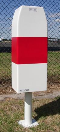
A ceilometer is a device that uses a laser or other light source to determine the height of a cloud ceiling or cloud base.[1] Ceilometers can also be used to measure the aerosol concentration within the atmosphere.[2] A ceilometer that uses laser light is a type of atmospheric lidar (light detection and ranging) instrument.[3][4]

Optical drum ceilometer

[edit]

An optical drum ceilometer uses triangulation to determine the height of a spot of light projected onto the base of the cloud.[5] It consists essentially of a rotating projector, a detector, and a recorder.[6] The projector emits an intense beam of light above into the sky at an angle that varies with the rotation. The detector, which is located at a fixed distance from the projector, uses a photodetector pointing vertically. When it detects the projected light return from the cloud base, the instrument notes the angle and the calculation gives the height of clouds.[7]

Laser ceilometer

[edit]

A laser ceilometer consists of a vertically pointing laser and a receiver in the same location. A laser pulse with a duration on the order of nanoseconds is sent through the atmosphere. As the beam travels through the atmosphere, tiny fractions of the light are scattered by aerosols. Generally, the size of the particles in question are similar in size to the wavelength of the laser.[8] This situation leads to Mie scattering.[9] A small component of this scattered light is directed back to the lidar receiver.[10] The timing of the received signal can be transformed into a spatial range, z, by using the speed of light. That is,

where c is the light speed in the air.

In this way, each pulse of laser light results in a vertical profile of aerosol concentration within the atmosphere.[11][12] Generally, many individual profiles will be averaged together in order to increase the signal-to-noise ratio and average profiles are reported on a time scale of seconds.[13] The presence of clouds or water droplets leads to a very strong return signal compared to background levels, which allows for cloud heights to be easily identified.[14]

Since the instrument will note any returns, it is possible to locate any faint layer where it occurs, additionally to the cloud's base, by looking at the whole pattern of returned energy. Furthermore, the rate at which diffusion happens can be noted by the diminishing part returned to the ceilometer in clear air, giving the coefficient of extinction of the light signal. Using these data could give the vertical visibility and the possible concentration of air pollutants. This has been developed in research and could be applied for operational purpose.[15]

In New Zealand, MetService operates a network of laser ceilometers for cloud base measurements at commercial airports. These sensors are also used to map volcanic ash clouds to allow commercial air traffic to avoid damage caused by ash. The movement of volcanic ash has also been tracked from areas such as Iceland.[16][17][18]

Examination of the behavior of ceilometers under various cloud-cover conditions has led to the improvement of algorithms to avoid false readings.[19] Accuracy of measurement can be impacted by the limited vertical range and areal extent of a ceilometer's area of observation.[20][21]

A common use of ceilometers is to monitor the cloud ceiling for airports.[22][23] A study group from Montreal, Canada in 2013 recommended that ceilometers should be installed "close to the landing threshold" for aerodromes with precision approach runways, but also considered their location "at the middle marker or at an equivalent distance" to be acceptable.[24]

Hazards

[edit]

Ceilometers that use visible light can sometimes be fatal to birds, as the animals become disoriented by the light beams and suffer exhaustion and collisions with other birds and structures.[25] In the worst recorded ceilometer non-laser light beam incident, approximately 50,000 birds from 53 different species died at Warner Robins Air Force Base in the United States during one night in 1954.[26]

Laser ceilometers use invisible lasers to observe the cloud base. Using optical instruments such as binoculars near ceilometers is not recommended, because lenses in instruments could concentrate the beam and damage one's eyes.[27][28]

See also

[edit]

References

[edit]
[edit]
Revisions and contributorsEdit on WikipediaRead on Wikipedia
from Grokipedia
A ceilometer is an active instrument used in to measure the height of bases, also known as the cloud ceiling, by emitting vertical pulses and detecting the backscattered from clouds. It operates on (Light Detection and Ranging) principles, calculating cloud height based on the time delay between pulse transmission and reception of the reflected signal from opaque or sufficiently dense cloud layers. Modern ceilometers, such as those integrated into automated stations, typically report cloud heights up to 12,000 feet (about 3.7 km) and can identify multiple cloud layers simultaneously, though they may not detect thin or low-density clouds. Ceilometers have evolved significantly since their early development for , transitioning from energy-intensive flashlamp-based projectors that emitted broad white light beams in the mid-20th century to more efficient laser-diode systems introduced in the . These early optical ceilometers used separate projectors and detectors to scan the , but they required frequent maintenance and consumed substantial power. By the late and , advancements led to eye-safe (GaAs) laser-diode ceilometers operating in the near-infrared spectrum, followed by solid-state erbium-glass lasers at 1.54 μm for improved performance in adverse weather like . Contemporary models, such as the CL31 or CT25K, offer vertical resolutions of 10 meters, ranges up to 7.5 km, and temporal resolutions of 15–30 seconds, enabling real-time monitoring of bases, vertical visibility in or , and even heights. The primary applications of ceilometers include determining cloud ceilings for safe aircraft takeoff and landing, contributing to aviation weather reports through systems like the Automated Surface Observing System (ASOS). They also support broader meteorological research, such as studying cloud dynamics, aerosol profiles, and atmospheric boundary layer evolution, with networks of ceilometers providing long-term data for climate analysis and weather forecasting models. In addition to cloud detection, advanced ceilometers with depolarization capabilities can distinguish between ice and liquid cloud phases or identify precipitation types, enhancing their utility in operational and scientific contexts.

Introduction

Definition and Purpose

A ceilometer is a specialized meteorological instrument designed to measure the height of cloud bases or ceilings above ground level by emitting a vertical beam of light into the atmosphere and detecting the backscattered signal from the lowest cloud layer. This device operates on the principle of active remote sensing, where the time delay between light emission and reflection reception allows for precise height determination, typically accurate to within tens of meters. The primary purpose of a ceilometer is to deliver real-time cloud height data essential for , enabling pilots and air traffic controllers to assess and potential hazards during takeoff, , and low-level flight operations. In meteorological applications, it supports and analysis by identifying elevations, which inform predictions of , formation, and atmospheric stability. Key components of a ceilometer include a source—often in the visible or —a sensitive detector to capture reflected photons, and an integrated ranging system that processes timing or angular data to compute distances. Measurements are conventionally reported in feet or meters above ground level, with ranges commonly extending up to several kilometers to cover operational needs. As part of broader atmospheric monitoring, ceilometers aid in profiling vertical structures like layers and heights.

Importance in Meteorology

Ceilometers play a critical role in by providing real-time measurements of heights and vertical , which are essential for determining conditions at airports and ensuring safe takeoffs and landings. These instruments deliver automated data on layers up to several kilometers, helping pilots and air traffic controllers assess risks from low ceilings or obscured , particularly in or low-cloud scenarios. For instance, networks of ceilometers installed at major airports, such as those required by the (FAA) in the United States for continuous monitoring, reduce delays and enhance operational efficiency. As of 2025, advancements include IoT-enabled models for real-time data analytics and deployments in polar regions for climate research. In meteorological research and forecasting, ceilometers contribute significantly to cloud layer analysis by detecting multiple cloud bases and revealing the vertical structure of the atmosphere, including distributions and dynamics. Modern ceilometers can identify up to three or more cloud layers simultaneously with high vertical resolution (typically 10–15 meters) and temporal frequency (every 10–30 seconds), enabling detailed profiling of atmospheric stability and mixing heights that inform models. This capability supports broader understanding of cloud formation processes and patterns, as demonstrated in studies of persistent cold-air pools where ceilometer mapped layered structures over extended periods. Ceilometers are often integrated with complementary instruments like to provide comprehensive atmospheric profiling, combining ground-based backscatter data with upper-air temperature, humidity, and wind measurements from balloon-borne sensors. This synergy allows for validation and refinement of heights, with comparisons showing strong correlations between ceilometer-derived and radiosonde-estimated profiles under various stability conditions. Such integration enhances models by filling spatial and temporal gaps in radiosonde launches, which occur only twice daily. Compared to traditional visual observations by meteorologists, ceilometers offer key advantages through , enabling continuous 24/7 operation in all conditions without fatigue or subjectivity, thus minimizing in cloud estimates. While visual methods are limited to clear views and prone to discrepancies (e.g., agreement within one height category about 67% of the time), ceilometers provide objective, range-resolved data that extends to nighttime and adverse visibility, improving reliability for operational . This shift to automated systems has standardized measurements across global networks, supporting more accurate and applications.

History

Early Developments

The principle of using light reflection to measure cloud heights was first demonstrated in 1871 by Danish meteorologist Poul la Cour, who employed projectors to send light beams toward clouds and calculated base heights trigonometrically based on the angle of reflection. This pioneering approach, published in Tidsskrift for Physik og Chemi, established the foundational concept for remote cloud ceiling detection without physical ascent. La Cour's method relied on visible scattering from cloud droplets, marking an early shift from manual balloon or kite-based observations to optical instrumentation. By the mid-1920s, the rapid growth of prompted the U.S. Weather Bureau to adopt practical implementations of la Cour's principle for routine cloud height measurements. Bureau observers used ceiling light projectors—essentially powerful searchlights elevated to tangent the —combined with trigonometric computations to determine heights, supplementing earlier techniques like small ceiling balloons. These manual optical systems improved night-time observations at airports, addressing the limitations of daylight-only visual estimates and supporting the expanding needs of air traffic. The onset of dramatically heightened the demand for reliable cloud ceiling data to ensure safe operations, accelerating the evolution toward automated and standardized optical ceilometers. In the , the U.S. Weather Bureau developed the rotating beam ceilometer, which projected a scanned and used a fixed optical receiver to detect reflections, enabling continuous, real-time measurements every few seconds. This instrument was quickly adopted by the U.S. military for airfield operations, with installations at major bases to mitigate risks from low ceilings during training and combat missions. By the late , such systems had become standard at over a dozen key U.S. airports, bridging manual optical methods to automation. These early developments paved the way for the transition to laser-based technologies in subsequent decades.

Modern Advancements

In the 1960s, ceilometers were introduced, marking a significant shift from mechanical drum-based systems to more precise and reliable optical technologies that utilized coherent light for cloud height detection. This innovation, demonstrated as early as 1965 by John D. Myers at the Lear-Siegler Laser Systems Centre, leveraged the recent invention of the to enable automated, high-resolution measurements without the mechanical limitations of earlier designs. From the 1980s through the 2000s, ceilometer technology evolved toward full (Light Detection and Ranging) implementations, emphasizing profiling to analyze and particulates in addition to cloud bases. Advancements in and detector technologies during this period improved signal quality and enabled the integration of ceilometers into dedicated aerosol networks, such as MPLNET and EARLINET established around 2000, which provided comprehensive vertical profiles for atmospheric research. Recent developments up to 2025 have focused on miniaturized, low-power automated ceilometers (ALCs) that support networked deployments for widespread monitoring. These systems, exemplified by networks like ALICENET in since 2015, facilitate four-dimensional profiling across multiple sites. Integration with has enhanced data processing, enabling real-time detection and classification of and layers through algorithms applied to profiles. Such advancements support climate monitoring by improving predictions of dynamics and transport. Key innovations include the adoption of eye-safe infrared lasers, typically at 1064 nm or 905 nm wavelengths, which ensure safe operation without compromising detection range. Automated calibration techniques further extend operational capabilities, allowing reliable profiling up to 15 km in altitude with vertical resolutions as fine as 10 .

Operating Principles

Basic Mechanism

Ceilometers measure cloud heights through the emission of a vertical , typically in the form of short pulses, directed upward into the atmosphere. This beam interacts with droplets or aerosols, causing backscattering of the light toward the instrument. A sensitive receiver detects the returned signal, and the time elapsed between emission and detection—known as the —enables the calculation of the height. The height hh is determined using the fundamental time-of-flight principle: h=ct2,h = \frac{c \cdot t}{2}, where cc is the (3×1083 \times 10^8 m/s) and tt is the round-trip time in seconds. This equation accounts for the light traveling to the and back, dividing the total distance by 2 to obtain the one-way . The precision of this method relies on accurate timing of the pulse return, often achieved with high-speed . To process the weak backscattered signals amid , the return light is amplified using specialized receivers and filters. Algorithms then apply thresholding techniques, identifying significant signal peaks that exceed predefined intensity levels to detect the first layer while distinguishing it from ground clutter or . These instruments typically offer a maximum range of 7.5–15 km and vertical resolutions of 5–15 meters, sufficient for operational needs.

Detection Methods

Detection methods in ceilometers focus on processing the backscattered light signals to interpret atmospheric structures, relying on the time-of-flight principle to associate signal returns with specific altitudes. Backscatter profiling analyzes variations in the intensity of returned signals to identify cloud bases, virga, and haze layers by detecting gradients in aerosol concentration or fitting idealized profiles to range-corrected data. Algorithms first evaluate signal quality, apply smoothing and corrections for range-dependent attenuation, then screen for significant backscattered layers to delineate boundaries such as the planetary boundary layer height. This approach enables automated monitoring of vertical aerosol distributions, with examples showing effective detection of mixing layer heights up to several kilometers. In LIDAR-capable ceilometers, depolarization ratios measure the polarization change in backscattered to differentiate cloud particle types, such as liquid droplets from crystals, based on their distinct scattering properties. This technique enhances phase discrimination at cloud bases, where low depolarization indicates spherical particles and higher values signal non-spherical . algorithms address atmospheric interference by filtering artifacts from rain, dust, or background , ensuring reliable signal interpretation. These include overlap corrections to account for near-range signal incompleteness, to reduce random noise, and screening to exclude contaminated profiles before boundary detection. Hardware elements, such as interference filters, further eliminate extraneous outside the , improving signal-to-noise ratios in varying weather conditions. Processed data yield output formats tailored to operational needs, including real-time ceiling height reports for and vertical backscatter profiles for research into aerosol layering. Integration with Doppler wind profilers in multi-instrument networks provides combined vertical profiles of height and , supporting comprehensive analysis in field campaigns.

Types of Ceilometers

Optical Drum Ceilometers

Optical drum ceilometers represent the traditional mechanical variant of cloud height measurement devices, employing non-coherent light sources and principles. The core design incorporates a rotating fitted with mirrored fan blades that direct a modulated in a conical scan pattern, projecting a spot of light onto the at varying elevation angles typically ranging from 8° to 85°. A separate receiver, located at a fixed known from the transmitter, captures the vertically scattered light from the intersection. This setup, exemplified by the AN/GMQ-2 model developed for and use, includes a unit, detector, and recorder, with the drum's rotation driven by an to complete a full scanning cycle in approximately one minute. In operation, the transmitter sweeps the upward and downward across the ; upon encountering a , the scattered interrupts the modulated signal, which is detected by a photocell and synchronized with the drum's angular position to compute the via . The AN/GMQ-2 supported both automatic mode, where the continuously scanned and recorded heights in feet on rotating ceilogram charts after a 12-minute period, and manual mode, involving cranking the drum to maximize signal deflection for direct reading from an angle scale, particularly useful for high or thin . Nighttime operation required adjustments like increased gain sensitivity and optional filters to enhance detection without sunlight interference. These instruments provided objective data to supplement human visual observations, reporting ceiling heights critical for . Key advantages of optical drum ceilometers included their mechanical simplicity and relatively low cost, facilitating broad deployment without the need for complex electronics, as well as the safety of using non-coherent light, which posed no eye hazards from beam exposure. They offered consistent, automated reporting that improved accuracy during nighttime conditions compared to manual estimates and minimized errors from observer fatigue or humidity effects on equipment. Despite these benefits, the design suffered from inherent limitations, including mechanical wear on the rotating and mirrors over time, heightened to from , , or strong winds due to exposed moving parts, and reduced effectiveness in low-visibility conditions below ½ mile or during heavy , where signal delays of up to 4 seconds could lead to misreporting of slow-moving or fluctuating bases. Their range was confined to lower altitudes, typically up to 2-3 km, beyond which light attenuation diminished detection reliability, and false signals from or extraneous sources further compromised accuracy. These shortcomings contributed to their gradual phase-out starting in the late . Historically, optical drum ceilometers served as the standard for cloud ceiling measurements at U.S. airports from the through the , integrated into Weather Bureau, , and operations under joint standards to support weather reporting and pilot briefings. Deployed at key locations like runway touchdown zones, they generated essential data for special observations and record purposes until replaced by more robust laser-based systems in the 1990s as part of the Automated Surface Observing System () modernization.

Laser Ceilometers

Laser ceilometers employ advanced technology to measure heights and atmospheric profiles with high precision, evolving from earlier optical systems to provide automated, essential for modern meteorological applications. The core design features a operating at wavelengths such as 905 nm or 1550 nm, integrated with a receiver in a optical arrangement that aligns the transmission and reception paths for efficient backscattering detection. This setup uses a as the light source, with the emitted pulses directed vertically into the atmosphere, where interactions with clouds or aerosols produce return signals captured by the receiver. In operation, these devices fire pulses at high repetition rates of up to 10 kHz, allowing for continuous vertical profiling of the atmosphere up to depths of 15 km, while photodiodes serve as the primary detectors for the weak backscattered light, enabling time-of-flight calculations for distance determination. The system's further refines these measurements to achieve vertical resolutions on the order of meters. Notable advantages include the capability to detect multiple cloud layers simultaneously, extended operational ranges suitable for aviation needs, and enhanced eye safety provided by the longer 1550 nm wavelength, which minimizes risks to human vision compared to shorter wavelengths. Modern implementations often integrate GPS for tagging measurements with precise site locations, particularly in mobile or networked deployments, alongside software algorithms that retrieve aerosol optical properties from backscatter data. Laser ceilometers adhere to international standards, including those set by the (ICAO) in Annex 3 for meteorological services to and the (WMO) guidelines for cloud height measurements, ensuring reliability and interoperability in global networks.

Applications

Aviation and Airport Operations

Ceilometers play a critical role in by measuring base heights, which determine minimum safe altitudes for aircraft takeoffs and landings, ensuring compliance with (VFR) and (IFR) requirements. These measurements are essential for calculating decision heights and minimum descent altitudes, particularly when integrated with (RVR) systems to assess overall visibility conditions along the runway. In automated surface observing systems (ASOS) and automated weather observing systems (AWOS), the ceilometer's data on cloud ceilings directly informs pilots and about potential hazards, such as low layers that could necessitate instrument approaches or ground holds. Regulatory standards mandate ceilometers at international airports to support safe operations, as outlined by the (FAA) and the (ICAO). Under FAA guidelines, ceilometers are a core component of and AWOS installations at certificated airports, providing continuous cloud height data to generate reports that comply with aviation weather standards. ICAO Annex 3 requires cloud height measurements via ceilometers or equivalent sensors at international aerodromes to ensure accurate reporting of sky conditions, with systems designed to update data approximately every minute for real-time dissemination. These requirements help maintain operational integrity during varying weather, with ceilometer outputs integrated into broader meteorological services for global consistency. During fog events, ceilometers enable proactive management to prevent flight delays by delivering precise cloud base information, allowing airports to activate procedures swiftly. For instance, at London Heathrow Airport, ceilometer networks have supported fog prediction and monitoring, reducing disruption during dense fog episodes that historically caused widespread cancellations, such as those in November 2015 across European hubs. Similarly, at New York John F. Kennedy International Airport, studies have characterized fog typologies over the area, facilitating low-visibility operations and minimizing delays during recurrent winter fog events. Enhancements in ceilometer technology involve coupling with automated weather stations to support low-visibility procedures (LVP), where cloud ceiling data triggers alerts for reduced capacity and specialized ground movements. In LVP scenarios, typically activated when ceilings drop below 200 feet or RVR falls under 550 meters, integrated systems use ceilometer outputs alongside visibility sensors to automate notifications and ensure compliance with ICAO standards for all-weather operations. This integration, as seen in networks like those employing or Campbell Scientific ceilometers, improves forecast accuracy for LVP states, reducing operational downtime at fog-prone airports.

Weather Forecasting and Research

Ceilometers provide essential real-time data on cloud base heights and vertical aerosol profiles, which are assimilated into numerical weather prediction (NWP) models to improve forecasts of cloud cover and precipitation. In operational systems like the High-Resolution Rapid Refresh (HRRR) and Rapid Refresh (RAP) models, ceilometer-derived cloud observations from surface networks, such as the Automated Surface Observing System (ASOS), enhance the initialization of cloud layers, leading to more accurate short-term precipitation predictions by better representing low-level moisture and stability. Studies using ceilometer data alongside sky imagers have evaluated cloud properties in the Weather Research and Forecasting (WRF) model, identifying errors in forecasts of cloud base height and coverage. In atmospheric research, ceilometers are widely used to profile (PBL) heights, distributions, and PBL dynamics by analyzing signals from atmospheric particles. These instruments detect the in to estimate PBL height (PBLH), offering continuous, automated monitoring that complements and other methods; for instance, comparisons at ARM sites have shown good agreement for ceilometer PBLH retrievals against profiles under unstable conditions, though weaker in stable conditions. Ceilometer data reveal diurnal PBL evolution and mixing layer homogeneity, aiding studies of and vertical transport in urban and rural environments, where layers indicate entrainment processes. Advanced algorithms, such as those using covariance or on profiles, refine PBLH estimates for research into and dispersion. Ceilometers support environmental monitoring by detecting backscatter from pollution plumes, volcanic ash, and wildfire smoke, enabling tracking of aerosol transport and vertical structure. In pollution events, ceilometer profiles identify plume heights and mixing, as seen in analyses of urban aerosol layers contributing to surface air quality degradation. For volcanic ash, such as during the 2021 La Palma eruption, ceilometers measured attenuated backscatter and depolarization ratios up to 0.3, estimating mass concentrations and plume dispersion over distances exceeding 2,000 km. Wildfire smoke plumes are similarly profiled, with multi-wavelength observations quantifying optical properties and radiative impacts, as in studies of Canadian wildfire transport to the U.S., where backscatter signals traced lofted particles aloft. Integration of ceilometers into global networks like the Atmospheric Radiation Measurement () program facilitates long-term studies by providing standardized PBL and data across diverse sites. At observatories, ceilometers operate alongside radars and lidars to monitor boundary layer-cloud interactions, contributing to datasets used in evaluating parameterizations for effects on budgets. These networks support research on variability, such as how PBL dynamics influence regional patterns, with ceilometer enabling statistical analyses of - feedbacks over decadal scales.

Hazards and Safety

Biological Hazards

Ceilometers employing visible light beams, particularly those used in early optical designs, pose significant risks to wildlife by disorienting nocturnal migrants. Migrating birds are attracted to the intense, vertical pillar of light, especially under overcast conditions during fall and spring seasons, leading to circling behavior that causes exhaustion, mid-air collisions, and fatal impacts with the ground, buildings, or other birds. This phenomenon was first documented in September 1948 at Nashville Airport, Tennessee, where birds collided with the ceilometer light source. Studies from the 1940s and 1950s reported 12 such incidents across 10 U.S. locations, including Nashville, Tennessee; Albany, New York; and Louisville, Kentucky, with fatalities ranging from 3 to over 1,000 birds per event, primarily affecting passerines like warblers and vireos. In severe cases, such as those reported in southern U.S. airfields, up to 25,000 birds perished in a single night due to attraction and subsequent disorientation. Historical estimates suggest hundreds of bird deaths annually at individual airport sites equipped with visible-beam ceilometers during peak migration periods. Insects, particularly moths and other nocturnal , are similarly drawn to the visible emissions from ceilometers, resulting in disrupted flight patterns, energy depletion, and heightened vulnerability to predators like bats. This attraction alters local insect distributions and behaviors, potentially cascading through ecosystems by reducing services and serving as prey for higher trophic levels. Vertical beams exacerbate these effects by creating concentrated zones of illumination that mimic natural celestial cues, leading to aggregation and increased mortality rates in affected areas. To mitigate these biological hazards, modern laser ceilometers operate at near- wavelengths, such as 910 nm, which are invisible to birds and most , thereby minimizing attraction and disorientation. Early efforts also included scheduling beam operations to avoid peak migration times and temporarily deactivating lights when safe for , a practice that prevented further casualties in documented cases. Additionally, filters were tested in the to reduce visibility to birds while maintaining functionality, though technology has become the standard for contemporary systems.

Human Safety Risks

Laser ceilometers present human safety risks primarily through potential eye injuries from exposure to the laser beam, which can cause retinal damage due to the focused energy on the . Modern systems, such as the CL31, are classified as Class 1M lasers under IEC 60825-1:2014 (harmonized with ANSI Z136.1 standards), meaning they are safe for direct viewing with the unaided eye but pose hazards when viewed through magnifying optical instruments like telescopes or , potentially leading to photochemical or retinal burns. Older gallium arsenide (GaAs) diode-based ceilometers were often classified as Class 3A or 3B, where direct beam exposure could cause immediate even without optical aids, emphasizing the need for caution during operation and maintenance. To mitigate these risks, manufacturers incorporate safety features such as automatic power shutoff when accessing internal components and recommend fully de-energizing the and before any maintenance involving the transmitter unit. Beam enclosures prevent unintended exposure, while nominal ocular distance (NOHD) calculations define zones where exposure exceeds safe limits, guiding site-specific restrictions—though for Class 1M systems, the naked-eye NOHD is typically zero meters. Regulatory bodies like the FAA require operational protocols, such as interlock devices and maintenance procedures, to minimize risks to nearby personnel, including pilots avoiding low-altitude overflights directly over active ceilometers (AC 150/5220-16D). Warning signage may be implemented under general standards like ANSI Z136.1. Documented incidents of laser-related eye injuries are rare for ceilometers specifically but include cases of retinal damage from accidental direct exposure during system alignment or maintenance on similar high-power laser setups, often resulting in permanent vision impairment if protective measures are ignored. Such events underscore the importance of procedural safeguards, as even brief exposure to misaligned beams in Class 3B or higher systems can exceed maximum permissible exposure (MPE) thresholds defined by ANSI Z136.1. Technicians operating or maintaining ceilometer systems must complete mandatory training and , covering recognition, control measures, and response, as required by ANSI Z136.1 for personnel handling Class 3B or Class 4 lasers—ensuring compliance through supervised initial use and periodic refreshers. This training is critical for high-power configurations, where improper handling during servicing poses the greatest risk to operators.

References

Add your contribution
Related Hubs
User Avatar
No comments yet.