Hubbry Logo
CorycusCorycusMain
Open search
Corycus
Community hub
Corycus
logo
8 pages, 0 posts
0 subscribers
Be the first to start a discussion here.
Corycus
Corycus
from Wikipedia
Fortress of Korikos built c. the thirteenth century.

Key Information

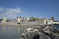
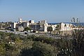
Corycus (Greek: Κώρυκος; also transliterated Corycos or Korykos; Armenian: Կոռիկոս, romanizedKoṙikos; Turkish: Kız Kalesi, lit. "maiden castle") was an ancient city in Cilicia Trachaea, Anatolia, located at the mouth of the valley called Şeytan deresi; the site is now occupied by the town of Kızkalesi (formerly Ghorgos), Mersin Province, Turkey.

The city

[edit]

Strabo does not mention a town of Corycus, but reports a promontory so called at the location, but a town Corycus is mentioned by Livy (xxxiii. 20), and by Pliny (v. 27), and Pomponius Mela (i. 13), and Stephanus of Byzantium (s. v. Κώρυκος). In antiquity, Corycus was an important harbor and commercial town. It was the port of Seleucia, where, in 191 BCE, the fleet of Antiochus the Great was defeated by the Romans. In the Roman times it preserved its ancient laws; the emperors usually kept a fleet there to watch over the pirates. Corycus was also a mint in antiquity and some of its coins survive.

Corycus was controlled by the Byzantine Empire.[1] Justinian I restored the public baths and a hospital. The admiral Eustathios Kymineianos re-fortified the island on the orders of Alexios I Komnenos at the beginning of the 12th century, adding a supplementary castle on a small island. This castle was later called "maidens castle", because it was told that a king held his daughter here in captivity until she was killed by a venomous snake. It was prophesied she would die by a snake bite. So she was taken to the sea castle to protect her, but a serpent was taken by basket to the castle, she was bitten and died. Corycus was conquered by the Armenians soon after it was rebuilt by the Byzantines.

Until the mid-14th century the Armenians held both the mainland and island castles, which guarded this strategic port for the Armenian Kingdom of Cilicia. Simon, the Baron of Koŕikos, attended the coronation of King Levon I in 1198/99. Subsequent Armenian nobles maintained authority in the area (with a few brief interruptions) until 1360, when Peter I, the King of Cyprus, removed the Mamelukes and assumed suzerainty. In the late 14th century it was seized again by the Turks. From 1448 or 1454 it belonged alternately to the Karamanids, the Egyptians, the Karamanids a second time, and finally to the Ottoman Empire.

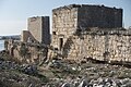
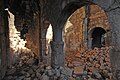
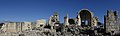
Archaeological surveys published in 1982 and 1987 found that the Armenians maintained (with occasional repairs) the mainland castle’s simple Byzantine plan with its rectangular double walls, square towers, and two chapels, all of which were built with masonry taken from the nearby late antique city. The only original Armenian construction is one small chapel.[2][3] Kizkalesi on the island has the extensive remains of Armenian rebuilding. The island was once connected to the mainland fort by a breakwater.

Views of the Fortress and ruins of the town (c. 1860)

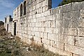
The ruins of the city are extensive. Among them are a triumphal arch, a necropolis with a beautiful Christian tomb, sarcophagi, etc. The two medieval castles, one on the shore, the other in an islet, connected by a ruined pier, are partially preserved; the former was reputed impregnable. The walls of the castle on the mainland contain many pieces of columns; and a mole of great unhewn rocks projects from one angle of the fortress about a hundred yards across the bay. Three churches are also found, one decorated with frescoes. The walls of the ancient city may still be traced, and there appear to be sufficient remains to invite a careful examination of the spot.

Bishopric

[edit]

The city figures in the Synecdemus of Hierocles, and in a Notitia Episcopatuum of about 840.[4] The bishopric of Corycus was a suffragan of Tarsus, the capital of the Roman province of Cilicia Prima, to which Corycus belonged. Of the bishops of the see, Germanus was at the First Council of Constantinople in 381; Sallustius took part in the Council of Ephesus in 431[5] and a synod held in Tarsus in 434, and was represented at the Council of Chalcedon by his metropolitan bishop Theodorus, who signed the acts of the council on his behalf; Archelaus went to a synod called by Patriarch Menas of Constantinople in 536; Cyprianus was at the Second Council of Constantinople in 553; and Ioannes participated in the Third Council of Constantinople in 680 and the Trullan Council in 692. During the crusades, Corycus was the seat of Latin Church bishops, one of whom, named Gerardus, took part in a council at Antioch in 1136.[6][7][8][9] No longer a residential bishopric, Corycus is today listed by the Catholic Church as a titular see.[10]

Two Armenian inscriptions that were discovered at the castles of Korykos were credited to its construction to Levon I and then to Hetum I.[11]

Corycian Cave

[edit]

In the Corycian Cave (now Cennet ve Cehennem), 20 stadia inland, says Strabo, the best crocus (saffron) grows. He describes this cave as a great hollow, of a circular form, surrounded by a margin of rock, on all sides of a considerable height; on descending into this cavity, the ground is found to be uneven and generally rocky, and it is filled with shrubs, both evergreen and cultivated; in some parts the saffron is cultivated: there is also a cave here which contains a large source, which pours forth a river of pure, pellucid water, but it immediately sinks into the earth, and flowing underground enters the sea: they call it the Bitter Water. Pomponius Mela (i.13) has a long description of the same place apparently from the same authority that Strabo followed, but more embellished. This place is probably on the top of the mountain above Corycus.

This place is famed in Greek mythology. It is the Cilician cave of Pindar (Pythian Ode i. 31), and of Aeschylus (Prom. Vinct. 350), and it is the lair of Zeus' fiercest opponent, the monster Typhon or Typhoeus.

See also

[edit]
[edit]

References

[edit]
[edit]
Revisions and contributorsEdit on WikipediaRead on Wikipedia
from Grokipedia
Corycus, also known as Korykos or Korikos, is an ancient port city located in Trachea along the Mediterranean coast in present-day , , renowned for its strategic harbor and fortifications spanning multiple historical periods. Founded by a prince named Korykos according to ancient accounts, the city emerged as a key trade hub, particularly during the Roman era for olive oil and wine production, and later under Byzantine and Armenian rule with impressive defensive structures like the land castle and the offshore Maiden's Castle (Kızkalesi). The site's history traces back to the , with initial control by the Seleucids in the 2nd century BCE, followed by Roman annexation and prosperity as a minting center and commercial port during the late Republic. By the CE, Corycus flourished in the Late Antique period as a vibrant maritime node connected to routes, including those to the cult of St. Thecla, supported by a rural and extensive building activity such as city walls, aqueducts, and 14 early Christian churches dating from the 4th to 7th centuries. After the division of the in 395 CE, it fell briefly to the before returning to Byzantine control, where it served as an important harbor until Armenian forces under the Kingdom of Cilician seized and fortified it in the 12th–13th centuries, constructing double-walled castles with chapels and a chain barrier for defense. The city endured sieges by the in the 15th century before Ottoman conquest in 1471, after which it declined, though its 113.4-hectare archaeological zone—including a Roman , villae rusticae, and unique Adamkayalar rock reliefs depicting 11 men, four women, two children, and a —remains a testament to its layered .

Overview and Location

Geographical Setting

Corycus, an ancient city in Trachaea, is located at approximately 36°27′55″N 34°09′15″E, overlaying the modern town of Kızkalesi in the Erdemli District of , . This positioning places it along the Mediterranean coastline, about 65 km southeast of and 25 km northwest of , integrated into the contemporary highway network. The site's coordinates reflect its strategic coastal placement, facilitating historical maritime activities within the rugged terrain of southern . Topographically, Corycus occupies the mouth of the Şeytan Deresi valley, where the landscape transitions from inland rocky slopes to the sea, forming a natural harbor characterized by two small bays. This valley, also known as Devils' Valley, provided a sheltered inlet along the Mediterranean coast, protected by promontories and enhanced by nearby islands such as Elaeussa and Crambusa. The harbor's configuration, spanning an east-west area of about 113.4 hectares including adjacent necropolis zones, offered defensible access points and supported the city's extension across coastal and valley terrains. The surrounding landscape features the mountainous backbone of Trachaea and the broader Taurus range, contributing to its role as a sheltered in this rough, limestone-rich region west of the Calycadnus River. It maintained connections to nearby ancient sites, notably serving as a key harbor linked to ad Calycadnum via coastal routes, integrating it into regional networks amid the area's steep passes and river valleys. This topography isolated interior settlements while emphasizing coastal hubs like Corycus for trade and transit. Environmentally, the Mediterranean coastal climate—marked by hot summers, mild winters, and seasonal precipitation—influenced settlement patterns by concentrating development around the natural harbor and , where reliable water access and fertile soils supported continuous occupation across periods. The rocky, karstic environment limited inland expansion but favored maritime-oriented communities, with the bays providing protection from open-sea storms and enabling sustained human presence despite the challenging terrain.

Name and Etymology

The ancient city of Corycus was known in Greek as Κώρυκος (Kōrykos) and in Latin as Corycus, denoting a prominent coastal settlement in Trachaea. This nomenclature appears in classical geographical works, where describes Corycus as a jutting into the , notable for its strategic position and proximity to the renowned Corycian . Pomponius references the town of Corycos. includes Corycus among the coastal locales of in his , cataloging it as a key point along the rugged southern Anatolian shore. The etymology of Kōrykos remains uncertain but is associated with saffron production, as the finest reportedly grew in the Corycian Cave according to , with local traditions linking the name to the Greek word for (krokos), though direct linguistic connections are unclear. Over time, the name evolved while retaining its core form: in Byzantine Greek, it persisted as Korykos, reflecting continued Greek cultural influence in the region. During the medieval period under Armenian rule, it was rendered as Koṙikos in Armenian sources, underscoring the site's role in the . Today, the location is encompassed by the modern Turkish town of Kızkalesi, literally "Maiden's Castle," named after the offshore island fortress central to local and the site's defensive architecture. To avoid confusion, this Corycus in Trachaea must be distinguished from homonymous ancient sites, such as another Corycus in (a on the southwestern Anatolian ) and a settlement on Crete's northwestern peninsula, both bearing the same Greek name but in different regions.

Historical Development

Prehistoric and

The region surrounding Corycus, located in Trachea, exhibits evidence of significant mining activities during the third and second millennia BCE, aligning with the broader metallurgical developments in southern . Archaeological analyses of metal artifacts and production sites in indicate a shift from arsenical to tin-bronze alloys, reflecting intensive exploitation of local ore deposits that supported regional and Mediterranean trade networks. Corycus, situated near natural harbors and mineral-rich valleys, likely served as a potential early settlement hub facilitating access to these resources, though direct excavations at the site remain limited and pre-Hellenistic layers are not extensively documented. During the Classical Greek period (5th–4th centuries BCE), Corycus emerged as a modest port city within , contributing to maritime trade routes that connected to the Aegean and Levantine coasts. While sources provide few direct references to Corycus itself, its strategic coastal position infers involvement in the exchange of goods such as metals, timber, and agricultural products, as part of Cilicia's integration into broader Hellenic commercial spheres. This role was enhanced by the region's natural harbors, which supported seasonal shipping without dominating the narrative in texts like those of or . Corycus fell under Persian influence as part of the Achaemenid satrapy of during the 5th century BCE, following the Great's conquests in the mid-6th century BCE. , including its Trachean districts, was administered as a distinct province responsible for tribute in silver, horses, and military levies, with Tarsus serving as the satrapal center; coastal sites like Corycus likely contributed to naval obligations and overland trade routes under this system. The satrapy maintained semi-autonomous local dynasties, such as the Syennesis line, blending Persian oversight with indigenous governance until Alexander the Great's campaigns disrupted Achaemenid control around 333 BCE. The transition to the Hellenistic era saw Corycus retain local autonomy briefly before integration into the in the late 4th/early 3rd century BCE following the , marking a period of gradual . By the 2nd century BCE, the city, designated as Polis Korikos, gained authorization to mint its own bronze coinage, featuring deities like and Hermes to symbolize prosperity and commerce, under Seleucid suzerainty. These issues, documented in numismatic catalogs, reflect emerging civic identity and economic independence within the broader Seleucid framework, paving the way for further development in subsequent periods.

Hellenistic and Roman Periods

During the , Corycus came under Seleucid control in the late 4th/early 3rd century BCE following the , when it was designated as Korikos; by the 2nd century BCE, it was granted the right to mint its own coins, reflecting its emerging status as an autonomous urban center. These coins often featured depictions of the city's fortifications crowned with a , symbolizing its defensive importance along the rugged Cilician coast. A pivotal event in this era occurred in 191 BCE, when the Roman fleet, allied with Pergamene forces under Gaius Livius Salinator, decisively defeated the Seleucid navy of Antiochus III near Corycus harbor during the Roman-Seleucid War, marking a significant blow to Seleucid naval power in the . Following the decline of Seleucid influence, Corycus was formally incorporated into the Roman sphere after 67 BCE, when Gnaeus Pompey the Great cleared the region of and reorganized Rough Cilicia as part of the of . Under Roman administration, the city expanded eastward, with new defensive walls constructed to enclose additional territory, enhancing its strategic role in provincial defense. This period saw the development of key structures, including an early —likely commemorating Roman military successes—and the expansion of the , which featured sarcophagi and rock-cut tombs indicative of growing urban prosperity. Economically, Corycus flourished as the primary harbor for the inland city of ad Calycadnum, facilitating trade in regional commodities such as , cultivated in nearby caves. Its commercial significance peaked in the CE, when the walls were further rebuilt and extended, supporting its integration into Roman provincial governance; notably, Marcus Tullius served as governor of , overseeing the region's administration from nearby bases. This era underscored Corycus's role as a vital maritime link in the empire's eastern trade networks, though its autonomy waned by the late 3rd century CE amid competition from emerging centers like Elaiussa Sebaste.

Byzantine and Medieval Eras

Following the division of the in 395 CE, Corycus briefly fell to Sassanid control before returning to rule. During the period, Corycus maintained its role as a vital commercial port in , facilitating the export of vine and products across the Mediterranean. The city's strategic location on the southern coast made it a key defensive outpost during the Byzantine-Arab wars of the 7th to 11th centuries, where its harbor supported naval operations and its fortifications were reinforced with walls to repel Arab raids and invasions. In the , contributed to the city's infrastructure by restoring the public baths and constructing a , enhancing its resilience amid ongoing regional conflicts. By the late 11th century, following Seljuk Turkic incursions that disrupted control over , ordered the re-fortification of Corycus around 1099, including enhancements to the , to secure the Cilician frontier. The city's fortunes shifted in the early when it was conquered by Armenian forces fleeing Seljuk invasions further east, integrating Corycus into the emerging . Under Armenian rule from the mid-12th to the mid-14th century, Corycus served as a crucial coastal stronghold, with its castles extensively rebuilt and expanded to bolster defenses against ongoing threats from Seljuk and later forces; for instance, in 1275, raiders advanced as far as Corycus during a devastating campaign against the kingdom. The port played a supportive role in the kingdom's alliances with , providing logistical aid through trade and naval access that facilitated joint military efforts against common Muslim adversaries in the 12th and 13th centuries. By the mid-15th century, following the kingdom's collapse amid conquests, Corycus experienced a turbulent transition, falling to the Karamanid Beylik around 1448 and changing hands between local powers before Ottoman incorporation by 1474, after which its prominence as a harbor and fortress waned significantly within the broader Ottoman province of .

Religious Significance

Early Christian Bishopric

The bishopric of Corycus emerged as a suffragan see of Tarsus within the of Cilicia Trachaea during the late Roman period, operating under the overarching authority of the Patriarchate of Antioch. This structure reflected the hierarchical organization of the early in Asia Minor, where local dioceses reported to metropolitan sees like Tarsus, which in turn aligned with the patriarchal jurisdiction of Antioch. The diocese's boundaries generally corresponded to the hinterland of of Corycus, including its port and surrounding rural territories along the Cilician coast, serving a growing Christian population amid the region's Roman administrative divisions. Historical records attest to the see's vitality through the participation of its bishops in key ecumenical councils, underscoring Corycus's role in doctrinal deliberations. Bishop Germanus represented the see at the in 381 AD, while Bishop Sallustius attended the in 431 AD. Further involvement is evidenced by bishops at the local council of 536 AD, the Second Council of Constantinople in 553 AD, and the Third Council of Constantinople in 680–681 AD. These engagements, documented across five known Greek bishops from 381 to 680 AD, highlight the diocese's adherence to orthodox and its integration into imperial church governance. In the Crusader era, following the Armenian conquest and Latin influence in , Corycus transitioned to a see, with Bishop Gerardus participating in a at Antioch circa 1136 AD. This shift accommodated Western ecclesiastical presence amid the principalities of the . By the , four additional Latin bishops are recorded, marking the see's adaptation to changing political landscapes under Armenian and later Turkish control. Post-14th century, as the residential bishopric lapsed due to territorial losses, Corycus was reconstituted as a of the , maintaining its historical nomenclature without active pastoral oversight. The has been vacant since the death of its last in 1967.

Notable Ecclesiastical Figures

The bishopric of Corycus produced several notable ecclesiastical figures during the early Christian era, particularly those who engaged in and doctrinal discussions central to controversies. Germanus served as of Corycus in the 4th century and attended an , where he contributed to debates on orthodox amid emerging heresies. Sallustius, in the , represented the see at the in 431, supporting the condemnation of and affirming the unity of Christ's divine and human natures in response to regional theological tensions. Archelaus, a 6th-century , continued this tradition by participating in synodal activities that reinforced Chalcedonian in against Monophysite challenges. In the , and Ioannes held the during a period of Arab incursions and internal church divisions, maintaining the bishopric's adherence to imperial ecclesiastical policies while navigating Christological disputes in the patriarchate of Antioch. Their efforts helped sustain Christian communities in amid political upheaval. During the Crusader period, Gerardus, a Latin of Corycus around 1136, attended the Council of Antioch, bridging Eastern and Western traditions and addressing jurisdictional issues in the Latin East. These figures' involvement in councils and local governance left a lasting legacy, influencing the spread and consolidation of orthodox across by promoting doctrinal unity and pastoral stability in a strategically vital region.

Architectural and Cultural Features

Fortifications and Castles

The fortifications of , an ancient coastal city in (modern-day southern ), represent a layered defensive system evolved over centuries to protect its strategic harbor and trade routes. Initial city walls date to the , constructed with polygonal masonry on rock outcrops, but significant expansions occurred in the AD during the Roman era, when the city grew eastward and new enclosing walls were built to fortify its expanded perimeter. These Roman structures incorporated elements like a , which later influenced subsequent defensive integrations. In response to incursions, the Byzantines rebuilt the walls in the as a double-row system, reusing Roman such as architectural fragments and water channels for enhanced resilience. This phase marked the origins of the mainland , a key component of Corycus's defenses, initially erected around 1099 under Emperor to safeguard the port and coastal road. The adopted a nearly square layout on flat rocky terrain, featuring a unique double-trace concentric design with square towers, a deep rock-cut ditch to the northeast serving as a , and a southern sea gate for maritime access. The seized control in the late , profoundly modifying the mainland castle between the 12th and 14th centuries by expanding it into a double-circuit surrounded by a water-filled and a raiseable bridge for entry. Additions included eight robust towers and internal cisterns for , blending defensive functionality with practical sustainment during sieges; three chapels—one Armenian and two Byzantine—were also incorporated, highlighting the site's ecclesiastical role within its walls. This Armenian phase emphasized layered barriers, with the outer circuit providing initial deterrence and the inner offering a fallback position. Complementing the mainland structure, the island castle—known today as Kızkalesi—lies approximately 200–400 meters offshore and was constructed in the medieval period on earlier foundations to control the bay. Of , it featured a single-circuit wall of about 192 meters, supported by eight square towers and a towered north gate, built using smooth from nearby late antique ruins. reconstructed parts, particularly the northwest section, adding rounded salients for improved resistance in the 13th century; the castle was formerly connected to the mainland castle by a breakwater. Overall, Corycus's fortifications exemplify a fusion of Roman, Byzantine, and Armenian architectural traditions: Roman provided foundational materials and scale, Byzantine designs introduced concentric defenses and reuse for efficiency, and Armenian innovations added moats, multi-towered circuits, and adaptive reconstructions to counter evolving tactics. , such as the mainland's bridge-accessed entrance and the island's north portal, integrated with these walls to manage controlled access, underscoring the site's role in regional .

The Corycian Cave

The Corycian Cave, located approximately 20 stadia (about 3.7 kilometers) inland from the ancient city of Corycus in a coastal valley, served as a notable natural landmark accessible via a path from the nearby harbor. Ancient accounts emphasize its role in local agriculture and hydrology, with the cave's interior providing fertile ground for saffron cultivation, renowned as the finest in the region. Today, it is identified with the site known as Cennet Mağarası (Heaven Cave), part of the Cennet and Cehennem sinkhole complex, though the ancient descriptions align primarily with the larger, accessible southern sinkhole. Strabo, in his Geography (Book 14, Chapter 5), portrays the cave as a vast circular hollow encircled by towering, sheer rocky brows, creating a natural enclosure with an earthen floor expansive enough to function as threshing-floors for the entire local population. A perennial stream traverses the bottom, its outlet a narrow, man-passable cleft in the rock that channels the water through a deep fissure, resulting in a bitter cascade emptying into the sea; this water was locally termed "Corycian water" due to its astringent quality. Complementing this, in his Chorographia (Book 1, Chapter 12) describes the cave's mouth as extraordinarily wide and gaping, its depth so profound that the bottom remains unseen, yet the flat interior is similarly vast and traversed by the same bitter river emerging via a constricted rocky passage. Mela further notes an adjacent cavern, also termed Corycium, characterized by extreme depth and , where echoes of a single cry reverberate up to seven times. Geologically, the Corycian Cave exemplifies a landscape formed in the limestone-rich , manifesting as a large or doline with vertical walls exceeding 70 meters in depth and an elliptical opening roughly 250 by 110 meters across. This karstic structure facilitates underground water circulation, including the stream observed by ancient writers, and supports the development of stalactites, stalagmites, and other speleothems within the deeper recesses, though the primary chamber's open nature limits extensive cavern formations. Such features underscore the cave's hydrological significance, with subterranean channels connecting inland precipitation to coastal outflow. This Cilician site holds distinct local importance for its practical and descriptive attributes in antiquity, separate from the Corycian Cave on in central Greece, which ancient sources like and Mela clearly differentiate by geographic context and lack mythological elaboration in the Cilician references.

Modern Site and Preservation

Archaeological Importance

The archaeological significance of Corycus lies in its well-preserved ruins, which provide insights into the Roman and Byzantine periods of Rough . Key discoveries include an extensive located north of the ancient highway, featuring numerous sarcophagi and rock-cut tombs dating to the Roman era, with varied grave types such as temple tombs and chamber graves that reflect local funerary practices. These artifacts, including inscribed sarcophagi, have yielded over 500 epigraphic texts documenting diverse social and ethnic groups, including a notable Jewish community integrated within the broader . Additionally, three Byzantine churches from the early Christian period have been identified and partially studied, contributing to understanding the site's transition to a Christian center, though the broader complex includes up to 14 preserved churches from the 4th to 7th centuries. Excavation history at Corycus has been limited, with most knowledge derived from 19th- and 20th-century surveys rather than large-scale modern digs. Early systematic documentation began in the 1880s, culminating in the comprehensive publication of necropolis inscriptions in 1931 by Josef Keil and Adolf Wilhelm as part of the Monumenta Asiae Minoris Antiqua series, which cataloged the site's epigraphic material without extensive physical excavation. More recent efforts include a 2001 archaeological excavation that uncovered skeletal remains from the necropolis, revealing evidence of ancient dental practices such as V-shaped mutilations, analyzed in Turkish scholarly reports. Potential Bronze Age mining artifacts have been noted in regional surveys, suggesting earlier pre-Roman activity, but these remain unconfirmed without targeted digs. Scholarly contributions have emphasized Corycus's role in regional studies of Rough . William M. Ramsay's travels through in the 1890s provided early descriptive accounts of the site's fortifications and , influencing subsequent topographic surveys, though he did not conduct excavations there. Recent Turkish archaeological reports, such as those from the and , highlight the site's integration into broader Cilician research, including analyses of funerary monuments like the sarcophagi, as detailed in Michael Blömer's 2011 study on Rough Cilicia's tomb architecture. These works underscore Corycus's value for examining cultural continuity from Hellenistic to medieval times. As of 2025, no major new excavations have been reported. Despite these advances, significant gaps persist in the , particularly in unexcavated areas like the ancient harbor, where updated geophysical surveys are needed to map submerged or buried structures and assess trade-related artifacts. The constructions at Corycus primarily date to the Roman and Byzantine periods, with later medieval reinforcements using from earlier phases.

Tourism and UNESCO Status

Korykos, known today as part of the Kızkalesi area in , serves as a key attraction within Turkey's Mediterranean circuit, drawing visitors to its ancient ruins alongside nearby beaches and resorts. The site is easily accessible via the D-400 coastal highway, approximately 65 km east of and 25 km from , with basic visitor facilities including parking areas, informational signage, and pathways leading to the land and sea castles as well as the and rock-cut tombs. Kızkalesi itself functions as a popular beach resort, featuring azure waters, sunbathing spots, and water sports, complemented by a range of accommodations from budget pensions to mid-range hotels that cater to both domestic and international tourists during the peak summer season. The site's coastal position exposes it to natural degradation, including erosion from sea waves and , which poses ongoing preservation challenges amid increasing visitor footfall. Turkish authorities, through the and Tourism, have implemented protective measures under the 1983 Conservation Act No. 2863, designating Korykos as a first-degree ; efforts intensified in the with monitoring programs to mitigate threats from urban expansion and tourism-related construction in the surrounding Kızkalesi area. Although no major restoration has occurred, the site's overall conservation state remains good, supported by regular inspections and restrictions on development to prevent further encroachment. As of 2025, no significant new preservation initiatives have been reported. In recognition of its layered spanning Hellenistic to Armenian periods, the Ancient City of Korykos was added to 's World Heritage Tentative List on April 15, 2014, under criteria (ii) for its eclectic architectural influences, (iii) for bearing exceptional testimony to continuous civilizations, and (iv) as an outstanding example of defensive architecture with its integrated sea and land castles. This status, unchanged as of 2025, highlights the site's value as a trade hub for ancient and wine production, emphasizing its role in illustrating Cilicia's historical connectivity. Tourism at Korykos significantly bolsters the local economy in Mersin Province, where seasonal influxes swell Kızkalesi's population from 1,781 residents (2022) with approximately 40,000 visitors during peak season, generating revenue through hospitality, guided tours, and related services. The site also promotes educational tourism, offering insights into Cilician history through its visible remains like churches and fortifications, fostering cultural awareness among travelers interested in the region's Greco-Roman and Byzantine legacies.

References

Add your contribution
Related Hubs
User Avatar
No comments yet.