Recent from talks
Nothing was collected or created yet.
De Pere, Wisconsin
View on Wikipedia

Key Information
De Pere (/di ˈpɪər/ dee-PEER)[7] is a city in Brown County, Wisconsin, United States. The population was 25,410 at the 2020 census.[8] It is part of the Green Bay metropolitan area.
History
[edit]
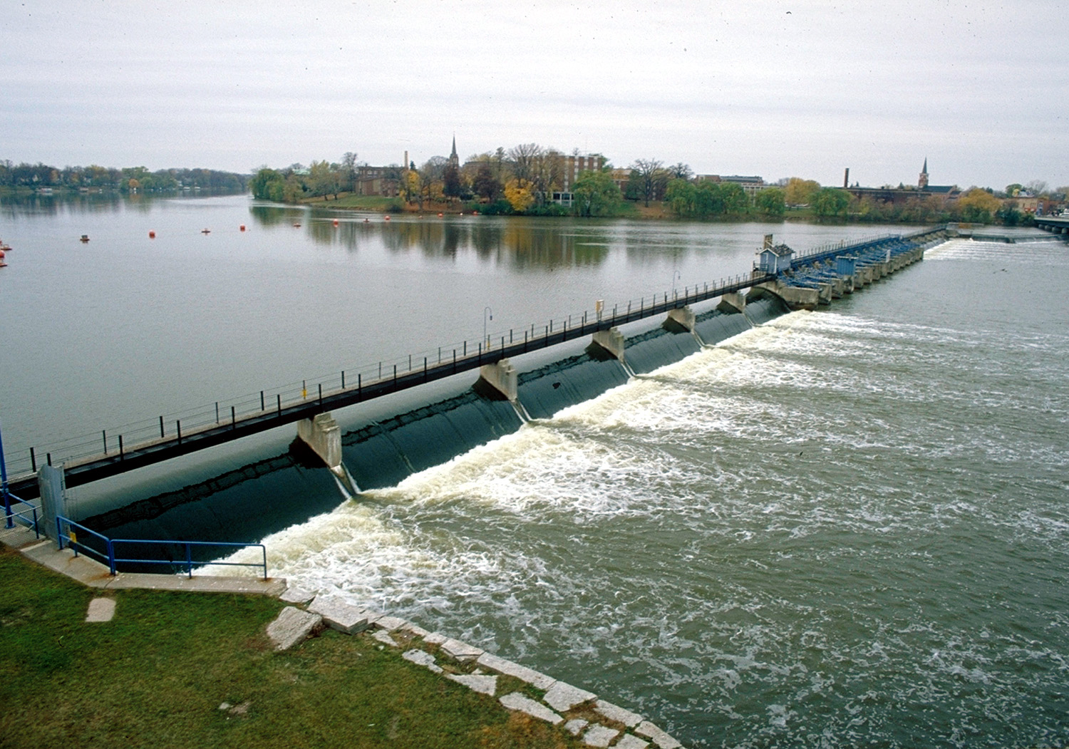
When the first European, Jean Nicolet, visited the place in 1634–35, De Pere was the site of a polyglot settlement of several thousand attracted by the fishing at the first rapids of the Fox River.[9] In 1671, French Jesuit explorer Père Claude-Jean Allouez founded the St. Francis Xavier Mission at the last set of rapids on the Fox River before it enters The Bay of Green Bay. The site was known as Rapides Des Pères (rapids of the fathers) which became modern day De Pere.[10]
The present city of De Pere had its beginnings in 1836, when John Penn Arndt and Charles Tullar incorporated the De Pere Hydraulic Company and drew up the first plat of the town.[11] In 1837, a popular vote established De Pere as the county seat of Brown County; it maintained this status until 1854, when another election moved the county seat to Green Bay.[12]
Politically, under the first township plan for Brown County, the area that is now the city of De Pere fell on the boundary between the town of Howard (which comprised much of the area west of the Fox River) and the town of "Mason", which comprised roughly the southern half of the county. In 1838, the area was first formally established by the territorial government as a separate township entity. At that time it was named the town of "Wilcox", for Randall Wilcox, who was then president of the De Pere Hydraulic Company, and it comprised most of the area of the current city of De Pere as well as the area that is now the town of Ledgeview, Wisconsin.
In 1839, the town of Wilcox was divided along the Fox River, with the eastern half becoming the town of De Pere (Ledgeview); the area west of the river was re-integrated into the town of Howard.[11] The village of De Pere was incorporated within the town of De Pere by an act of the state legislature on March 6, 1857.[13] West De Pere, on the west side of the river, was eventually set off from Howard as a separate town, and in 1870, the village of West De Pere was incorporated.
The west–east division at the river persisted until 1890. In 1883 the village of De Pere was re-incorporated as the city of De Pere, that same year the village of West De Pere was re-incorporated as the city of Nicolet (after voyageur Jean Nicolet). In 1887 the city of Nicolet was renamed the city of West De Pere, and in 1890 the city of West De Pere was finally consolidated into the city of De Pere to form a single city government.[14]
St. Norbert College, which abuts the banks of the Fox River on the city's west side near the Claude Allouez Bridge, was founded by Norbertine Abbot Pennings in 1898.
Registered historic places
[edit]De Pere has several areas on the National Register of Historic Places. North Broadway Street Historic District is listed as #83003368. Large homes line Broadway, Ridgeway Blvd., Morris, Fulton, Franklin, Cass, Front, and Wisconsin Streets near the Fox River.[15]
The De Pere Lock and Dam Historic District (#93001331) was added in 1993.[16]
The Union Hotel was added to the list in 2003.
The Randall Avenue Historic District and North Michigan Street-North Superior Street Historic District were added in 2007.
The Edwin and Jennie Gutknecht House was listed in 2015.
The St. Norbert College Historic District was added to the list in 2018.
The Mansion Street World War II Defense Housing Historic District and the Daviswood Ranch Homes Historic District were added to the list in 2021.[17][18]
Geography
[edit]De Pere is located at 44°26′46″N 88°4′27″W / 44.44611°N 88.07417°W (44.4460910, −88.0740510).[19]
According to the United States Census Bureau, the city has an area of 12.30 square miles (31.86 km2), of which 11.58 square miles (29.99 km2) is land and 0.72 square miles (1.86 km2) is water.[20]
Climate
[edit]
| ||||||||||||||||||||||||||||||||||||||||||||||||||||||||||||||||||||||||||||||||||||||||||||||||||||||||||||||||||||||||||||
Demographics
[edit]| Census | Pop. | Note | %± |
|---|---|---|---|
| 1860 | 508 | — | |
| 1870 | 1,372 | 170.1% | |
| 1880 | 1,954 | 42.4% | |
| 1890 | 3,625 | 85.5% | |
| 1900 | 4,038 | 11.4% | |
| 1910 | 4,477 | 10.9% | |
| 1920 | 5,165 | 15.4% | |
| 1930 | 5,521 | 6.9% | |
| 1940 | 6,373 | 15.4% | |
| 1950 | 8,146 | 27.8% | |
| 1960 | 10,045 | 23.3% | |
| 1970 | 13,309 | 32.5% | |
| 1980 | 14,892 | 11.9% | |
| 1990 | 16,569 | 11.3% | |
| 2000 | 20,559 | 24.1% | |
| 2010 | 23,800 | 15.8% | |
| 2020 | 25,410 | 6.8% | |
| U.S. Decennial Census[22] | |||
2020 census
[edit]As of the census of 2020,[23] the population was 25,410. The population density was 2,125.3 inhabitants per square mile (820.6/km2). There were 10,305 housing units at an average density of 861.9 per square mile (332.8/km2). The racial makeup of the city was 87.9% White, 2.1% Asian, 1.9% Black or African American, 1.3% Native American, 0.1% Pacific Islander, 1.4% from other races, and 5.2% from two or more races. Ethnically, the population was 4.2% Hispanic or Latino of any race.
2010 census
[edit]As of the census[2] of 2010, there were 23,800 people, 9,254 households, and 5,869 families living in the city. The population density was 2,055.3 inhabitants per square mile (793.6/km2). There were 9,742 housing units at an average density of 841.3 per square mile (324.8/km2). The racial makeup of the city was 94.0% White, 0.9% African American, 1.2% Native American, 1.5% Asian, 0.7% from other races, and 1.8% from two or more races. Hispanic or Latino of any race were 2.1% of the population.
There were 9,254 households, of which 33.2% had children under the age of 18 living with them, 49.4% were married couples living together, 9.9% had a female householder with no husband present, 4.1% had a male householder with no wife present, and 36.6% were non-families. 29.2% of all households were made up of individuals, and 10.8% had someone living alone who was 65 years of age or older. The average household size was 2.39 and the average family size was 2.97.
The median age in the city was 33.7 years. 23.8% of residents were under the age of 18; 14.1% were between the ages of 18 and 24; 26.4% were from 25 to 44; 23.9% were from 45 to 64; and 11.7% were 65 years of age or older. The gender makeup of the city was 47.9% male and 52.1% female.
2000 census
[edit]As of the census of 2000,[4] there were 20,559 people, 7,724 households, and 5,020 families living in the city. The population density was 1,938.4 people per square mile (748.2/km2). There were 7,993 housing units at an average density of 753.6 per square mile (290.9/km2). The racial makeup of the city was 96.71% White, 0.54% African American, 0.92% Native American, 0.75% Asian, 0.03% Pacific Islander, 0.19% from other races, and 0.86% from two or more races. Hispanic or Latino of any race were 0.98% of the population.
There were 7,724 households, out of which 33.9% had children under the age of 18 living with them, 54.2% were married couples living together, 7.7% had a female householder with no husband present, and 35.0% were non-families. 27.6% of all households were made up of individuals, and 10.5% had someone living alone who was 65 years of age or older. The average household size was 2.46 and the average family size was 3.04.
In the city, the population was spread out, with 24.5% under the age of 18, 14.8% from 18 to 24, 30.8% from 25 to 44, 18.5% from 45 to 64, and 11.4% who were 65 years of age or older. The median age was 32 years. For every 100 females, there were 93.6 males. For every 100 females age 18 and over, there were 89.6 males.
The median income for a household in the city was $50,282, and the median income for a family was $61,688. Males had a median income of $39,710 versus $27,166 for females. The per capita income for the city was $24,013. About 2.3% of families and 4.0% of the population were below the poverty line, including 3.2% of those under the age of 18 and 5.4% of those 65 and older.
Religion
[edit]St. Mark Lutheran Church is a member of the Wisconsin Evangelical Lutheran Synod in De Pere.[24][25]
The National Shrine of Saint Joseph is located at St. Norbert College.
St. Norbert Abbey is the mother canonry of the Premonstratensian Order in the United States.
Government
[edit]
De Pere is represented by Tony Wied in the United States House of Representatives, and by Ron Johnson and Tammy Baldwin in the United States Senate. Jamie Wall represents De Pere in the Wisconsin State Senate, while Benjamin Franklin represents De Pere in the Wisconsin State Assembly.
De Pere has a mayor-council form of government with a full-time city administrator. The mayor is elected. The city council consists of eight alderpersons, two elected from each of four districts. All elected officials serve two-year terms.[26]

Education
[edit]
De Pere is served by two school districts.
The Unified School District of De Pere has the following schools:
- De Pere High School
- De Pere Middle School
- Foxview Intermediate School
- Dickinson Elementary School
- Heritage Elementary School
- Altmayer Elementary School
The School District of West De Pere has the following schools:
- West De Pere High School
- West De Pere Middle School
- West De Pere Intermediate School
- Westwood Elementary School
- Hemlock Creek Elementary School
- Phantom Knight Charter School
De Pere Private Schools:
- Notre Dame of De Pere
- Our Lady of Lourdes
De Pere is also home to St. Norbert College, a private Roman Catholic liberal arts college.
Syble Hopp is a school for children ages 3–21 years old who have cognitive and other developmental disabilities. It is operated by the Brown County Children with Disabilities Education Board.[27]
Transportation
[edit]
Interstate 41 travels north–south on the west side of De Pere. Wisconsin Highway 32/Wisconsin Highway 57 enter De Pere from the south and split in the middle of De Pere. WIS 32 heads east–west through De Pere before turning north. WIS 57 continues straight north. There is limited transit service operated by Green Bay Metro and the CN provides freight railroad service. The Fox River is navigable for boat and canoe traffic with the exception of a dam.
Notable people
[edit]This section needs additional citations for verification. (November 2024) |
- Arthur J. Altmeyer, Commissioner of Social Security
- Jason Berken, MLB player
- Wilson Charles, athlete
- Chris Henry Coffey, actor
- Robert John Cornell, Roman Catholic priest, former member of the United States House of Representatives
- Oliver Daniel, arts administrator, musicologist, and composer
- Charles W. Day, Wisconsin State Senator
- Gary T. Dilweg, Wisconsin State Representative
- M. H. Fisk, first mayor of De Pere
- Burley Follett, former mayor of Green Bay, Wisconsin
- Ben Franklin, Wisconsin State Representative
- Paul Gigot, political commentator
- Earl Gilson, Wisconsin State Representative
- Charles Hall, Wisconsin State Representative
- Robert J. Havighurst, physicist
- Charlie Hill, comedian
- James F. Hughes, U.S. Representative
- Henry J. Janssen, Wisconsin State Representative
- Stephen King, Author
- Joseph Konopka, incarcerated terrorist known as "Dr. Chaos"
- Scott McCurley, NFL assistant coach
- Robert J. McGeehan, Wisconsin State Senator
- Terry Anne Meeuwsen, Miss America 1973, Miss Wisconsin 1972, co-host of the 700 Club
- George F. Merrill, Wisconsin State Senator
- Enos Warren Persons, Wisconsin State Senator
- John Schneider, NFL executive
- John L. Schnitzler, Wisconsin State Representative
- Edward A. Seymour, Wisconsin State Representative
- Alexander H. Smith, mycologist
- Gale Staley, MLB player
- William J. Sweeney, Wisconsin State Representative
- Tony Wied, member of the U.S. House of Representatives[28]
- Randall Wilcox, first village president of De Pere
References
[edit]- ^ "2019 U.S. Gazetteer Files". United States Census Bureau. Retrieved August 7, 2020.
- ^ a b "U.S. Census website". United States Census Bureau. Retrieved November 18, 2012.
- ^ "De Pere ZIP Code". zipdatamaps.com. 2023. Retrieved January 12, 2023.
- ^ a b "U.S. Census website". United States Census Bureau. Retrieved January 31, 2008.
- ^ "US Board on Geographic Names". United States Geological Survey. October 25, 2007. Retrieved January 31, 2008.
- ^ "Population and Housing Unit Estimates". United States Census Bureau. May 24, 2020. Retrieved May 27, 2020.
- ^ MissPronouncer.com: A HALFWAY DECENT AUDIO PRONUNCIATION GUIDE FOR WISCONSIN
- ^ "U.S. Census Bureau QuickFacts: De Pere city, Wisconsin". www.census.gov. Retrieved August 21, 2021.
- ^ One or more of the preceding sentences incorporates text from a publication now in the public domain: Chisholm, Hugh, ed. (1911). "De Pere". Encyclopædia Britannica. Vol. 8 (11th ed.). Cambridge University Press. p. 56.
- ^ Gannett, Henry (1905). The Origin of Certain Place Names in the United States. Govt. Print. Off. pp. 104.
- ^ a b Martin, Deborah Beaumont (1913). History of Brown County, Wisconsin, Past and Present. Vol. 1. S. J. Clarke Publishing Company. p. 164. Retrieved December 6, 2023.
- ^ Martin 1913, pp. 165–167.
- ^ Martin 1913, p. 305.
- ^ Milquet, Mary Kay. "De Pere History" De Pere Historical Society website [n.d.]; accessed November 24, 2021
- ^ "WISCONSIN – Brown County – Historic Districts", Retrieved June 5, 2007
- ^ "WISCONSIN – Brown County – Vacant / Not In Use", Retrieved June 5, 2007
- ^ "902-942 Mansion St | National or State Registers Record". Wisconsin Historical Society. January 1, 2012. Retrieved May 24, 2022.
- ^ "800-868 E St Francis Rd, 802-879 W St Francis Rd | National or State Registers Record". Wisconsin Historical Society. January 1, 2012. Retrieved May 24, 2022.
- ^ "US Gazetteer files: 2010, 2000, and 1990". United States Census Bureau. February 12, 2011. Retrieved April 23, 2011.
- ^ "US Gazetteer files 2010". United States Census Bureau. Archived from the original on July 2, 2012. Retrieved November 18, 2012.
- ^ "NASA Earth Observations Data Set Index". NASA. Archived from the original on April 26, 2020. Retrieved January 30, 2016.
- ^ "Census of Population and Housing". Census.gov. Retrieved June 4, 2015.
- ^ "2020 Decennial Census: De Pere city, Wisconsin". data.census.gov. U.S. Census Bureau. Retrieved July 8, 2022.
- ^ "St. Mark Lutheran Church".
- ^ "WELS Locator Search – Results".
- ^ "Mayor & Common Council". City of De Pere, Wisconsin. Retrieved May 24, 2022.
- ^ "Brown County Syble Hopp School". Archived from the original on August 11, 2006. Retrieved September 29, 2008.
- ^ Schilz, Indiana; Steeno, Paul (August 13, 2024). "Tony Wied wins Republican nominee for Wisconsin's 8th Congressional District after Roth concedes". We Are Green Bay. Retrieved November 6, 2024.
External links
[edit]De Pere, Wisconsin
View on GrokipediaHistory
Early settlement
The region now known as De Pere was originally inhabited by several Native American tribes, including the Menominee, who had long-established villages along the Fox River, as well as the Winnebago and Potawatomi.[9] By the early 19th century, additional tribes from the east, such as the Oneida, Brothertown, Stockbridge, and Munsee, arrived around 1820, with the Oneida specifically relocating from New York to lands purchased from the Ho-Chunk and Menominee near Green Bay, establishing a presence in the broader area that included De Pere.[9][6] European exploration of the area began in 1634 when French explorer Jean Nicolet landed on the east shore of Green Bay at Red Banks, approximately four miles north of present-day De Pere, after a 1,000-mile canoe journey from Montreal; he encountered local Native Americans and noted the abundance of furs, which later drew traders and missionaries to the region.[9][10] In 1671, Jesuit missionary Claude-Jean Allouez founded the Mission of St. Francis Xavier at Rapides des Pères on the east side of the Fox River in De Pere, marking the first permanent European settlement in Wisconsin; the mission served as a center for proselytizing among local tribes and included a bark-and-cedar chapel that supported early fur trading activities.[9][11] By the early 19th century, De Pere had evolved into a key fur trading post along the Fox River, facilitating exchanges between European traders and Native Americans following the decline of French control after 1763 and British handover in 1783.[6] Prominent figures in this era included William Dickinson, who built the first permanent home in De Pere in 1829 after relocating from nearby Shantytown, and Morgan L. Martin, who arrived in the Green Bay area in 1827 and played a central role in land development and river improvements to support trade and settlement in Brown County.[9][12] Charles Tullar, alongside John P. Arndt and Dickinson, established the De Pere Hydraulic Company in 1836, constructing the area's first dam across the Fox River to harness waterpower for milling, which shifted economic focus from fur trade to agriculture and industry.[9] Non-indigenous population growth accelerated in the 1830s and 1840s, driven by the river's rapids providing hydropower for gristmills and sawmills, with the first flour mill operational by 1843 producing 50 barrels per day; Brown County was formed in 1836 with De Pere as its initial seat, attracting settlers including early Irish immigrants by 1850.[9][13] Danish immigrants began arriving around 1848, initially settling in what was then part of De Pere township before the creation of New Denmark in 1855, contributing to farming and later the local cheese industry.[13] By the mid-1850s, these developments had fostered a small but growing community centered on river access and milling, setting the stage for further expansion.[13]Incorporation and modern growth
De Pere was formally established as a village in March 1857, building on its early settlement as a trading and mission site along the Fox River.[14] The adjacent Village of West De Pere was incorporated in 1870.[14] In 1883, the Wisconsin State Legislature reincorporated the Village of De Pere as the City of De Pere, while West De Pere was separately incorporated as the City of Nicolet that same year; the latter's name was changed back to West De Pere in 1887.[14] The two cities consolidated in 1890, forming the unified City of De Pere under a single municipal government.[14] The late 19th and early 20th centuries marked significant industrial expansion in De Pere, fueled by the arrival of railroads and the harnessing of the Fox River for milling operations. Rail service reached the area in the 1870s via the Milwaukee & Northern Railway, which connected De Pere to Green Bay and broader markets starting in 1873, facilitating the transport of goods and people.[15] Complementing this, dams on the Fox River powered multiple mills by mid-century, including three sawmills, two lathe mills, and a flour mill by 1850, which supported lumber and grain processing central to the local economy.[16] This period also saw the founding of St. Norbert College in 1898 by Norbertine Abbot Bernard Pennings, establishing a key educational institution that drew on the community's Catholic heritage and contributed to its cultural development.[17] In the 20th century, De Pere underwent suburbanization, particularly following World War II, as population growth aligned with the expanding Green Bay metropolitan area and attracted families seeking residential opportunities near urban amenities.[18] This boom transformed neighborhoods west of the river into typical post-war suburban layouts, emphasizing single-family homes and community infrastructure. The city's motto, "Runs Deeper," was adopted to evoke its enduring connection to the Fox River and its role in shaping local identity and heritage.[19] By the 21st century, De Pere had fully integrated into the Green Bay metropolitan statistical area, benefiting from regional economic ties while maintaining its distinct riverside character. The population reached 25,410 by 2020, reflecting sustained residential appeal within the broader metro framework.Registered historic places
De Pere, Wisconsin, features several districts and properties listed on the National Register of Historic Places (NRHP), preserving key aspects of its architectural, engineering, and educational heritage. These sites reflect the city's development from the 19th century onward, including residential neighborhoods, river infrastructure, and institutional growth. The listings highlight efforts to maintain structures that contributed to De Pere's role as a riverfront community and educational center. The North Broadway Street Historic District, encompassing approximately 28 acres along North Broadway and adjacent streets, includes 59 contributing buildings primarily constructed between 1836 and 1923. This residential area showcases a variety of architectural styles, such as Queen Anne, Victorian, and Colonial Revival, representing De Pere's evolution as a cohesive neighborhood during periods of economic expansion tied to the Fox River. The district was added to the NRHP on September 8, 1983.[20][21] The De Pere Lock and Dam Historic District preserves 19th-century hydraulic engineering along the Fox River, including remnants of dams, locks, and related structures built between 1855 and 1936 to facilitate navigation and industrial transport. Originally developed to overcome river rapids for steamboat and logging traffic, the site underscores De Pere's importance in regional commerce and waterway improvements. It was listed on the NRHP on December 7, 1993, as part of the broader Waterway Resources of the Lower Fox River.[22][23] The St. Norbert College Historic District, situated on the Fox River's west bank, comprises ten contributing buildings erected from 1898 to 1963, illustrating the institution's growth from a seminary to a liberal arts college. Architectural styles range from Richardsonian Romanesque in early structures like Old St. Joseph Church to mid-20th-century modern designs, reflecting Catholic educational influences in the community. The district was added to the NRHP on April 19, 2018.[24][25] Preservation in De Pere is supported by organizations like the De Pere Historical Society, which maintains the White Pillars Museum—a Greek Revival structure built in 1836 as a payroll office for the De Pere Hydraulic Company and listed on the NRHP as part of the North Broadway Street Historic District. Housed at 403 North Broadway within the North Broadway Street Historic District, the museum serves as an archive for local artifacts and promotes awareness of the city's heritage through exhibits and restoration projects. In June 2025, the society broke ground on a $5.3 million expansion project to preserve and encase the original building while adding space for archives and public exhibits.[26][5][27]Geography
Location and topography
De Pere is located in Brown County, Wisconsin, at coordinates 44°26′46″N 88°4′27″W.[28] The city has a total area of 12.30 square miles (31.86 km²), of which 11.58 square miles (29.99 km²) is land and 0.72 square miles (1.87 km²) is water, and forms part of the Green Bay metropolitan statistical area.[29][30] The city's topography features an average elevation of approximately 600 feet above sea level and is characterized by relatively flat terrain with a maximum elevation change of about 82 feet within a 2-mile radius.[31] Situated along the banks of the Fox River, a major tributary flowing into Green Bay, De Pere is divided into East De Pere and West De Pere by the river, a distinction originating from its historical development on both sides before unification in 1890.[3] Environmental features include riverwalk areas along the Fox River that provide opportunities for wildlife viewing, such as access to Government Island and surrounding habitats.[32] The region also encompasses wetlands, exemplified by the pond and surrounding wetland areas at St. Norbert Abbey, which support local biodiversity.[33] De Pere lies approximately 5 miles south of Green Bay and indirectly benefits from proximity to Lake Michigan via the Green Bay estuary, where the Fox River's presence contributes to a moderating local microclimate.[3][3]Climate
De Pere experiences a humid continental climate classified as Dfb under the Köppen system, characterized by cold, snowy winters and warm, humid summers.[34] The annual average temperature is 45.7°F, with total precipitation averaging 31.6 inches and snowfall reaching 55.6 inches per year, based on 1991–2020 normals from the nearby Green Bay station.[35] Winters are severe, with January averaging 18.3°F and frequent snowfall contributing to the region's high annual total, often enhanced by lake-effect snow from Lake Michigan.[35] Summers are mild to warm, peaking in July at an average of 70.5°F, though humidity can make conditions feel warmer.[35] The proximity to Lake Michigan provides some moderation, reducing temperature extremes compared to inland areas, while the Fox River valley setting can trap fog and cool air in low-lying areas during transitional seasons. Temperature extremes include a record high of 104°F set on July 13, 1936, and a record low of -36°F on January 21, 1888, both recorded at the Green Bay station representative of the De Pere area.[36] De Pere's location exposes it to the Great Lakes snowbelt, where northerly winds off Lake Michigan can deposit heavy snow accumulations during winter storms, sometimes exceeding 20 inches in a single event.Demographics
2020 census
As of the 2020 United States Census, De Pere had a population of 25,410 residents. The population density was 2,125.4 inhabitants per square mile (821.1/km²), calculated over a land area of 11.96 square miles (30.98 km²). The racial and ethnic composition of De Pere's population was predominantly White, reflecting the city's location in northeastern Wisconsin. According to census data, 87.9% of residents identified as White alone, 2.1% as Asian alone, 1.9% as Black or African American alone, 1.3% as American Indian and Alaska Native alone, and 5.2% as two or more races. Additionally, 4.2% of the population identified as Hispanic or Latino of any race. Household characteristics from the associated American Community Survey (ACS) data integrated with the 2020 Census indicated a median age of 36.2 years (as of 2023 ACS), suggesting a relatively young community compared to national averages. The median household income was $80,550 (as of 2023 ACS), with an average household size of 2.38 persons (as of 2023 ACS), and a poverty rate of 6.45% (as of 2023 ACS). These figures underscore De Pere's stable socioeconomic profile, supported by its proximity to the Green Bay metropolitan area.| Demographic Category | Percentage |
|---|---|
| White alone | 87.9% |
| Asian alone | 2.1% |
| Black or African American alone | 1.9% |
| American Indian and Alaska Native alone | 1.3% |
| Two or more races | 5.2% |
| Hispanic or Latino (any race) | 4.2% |
Historical population trends
The population of De Pere has shown consistent growth since 2000, reflecting broader suburban expansion in the Green Bay metropolitan area. According to U.S. Census Bureau data, the city recorded 20,559 residents in the 2000 census, increasing to 23,800 by 2010—a rise of approximately 15.8%. This growth continued steadily, reaching 25,410 in the 2020 census.[37]| Year | Population | Percent Change from Previous Decade |
|---|---|---|
| 2000 | 20,559 | — |
| 2010 | 23,800 | +15.8% |
| 2020 | 25,410 | +6.8% |

