

Kurnool district
View on Wikipedia
Kurnool district is one of the eight districts in the Rayalaseema region of the Indian state of Andhra Pradesh after the districts are reorganised in April 2022.[2] It is located in the north western part of the state and is bounded by Nandyal district in the east, Anantapur district in the south, Raichur district of Karnataka in the northwest, Bellary district of Karnataka in the west, and Jogulamba Gadwal district of Telangana in the north. It has a population of 2,271,686 based on the 2011 census.[2] The city of Kurnool is the headquarters of the district. Konda Reddy Fort, Mantralayam and Orvakal Rock Garden, Kurnool are tourist places of interest in the district.
Key Information


.svg)


Etymology
[edit]The name Kurnool was originally called "Kandenavolu". In the 11th century CE, the Oddera community engaged in construction activity used this place as a halting place for greasing their cartwheels with oil, before crossing the Tungabhadra river. The carts carried loads of stones for temple construction at Alampur. The word oil is known as kandena in Telugu and thus the place was called "Kandenavolu".[6]: 3
History
[edit]

The Ketavaram rock paintings are dated back to the Paleolithic era (located at a distance of 18 km (11 mi) from Kurnool).[7] Jurreru Valley, Katavani Kunta[8] and Yaganti in the Nandyal district have some important rock arts and paintings in their vicinity, which are dated back to 35,000 to 40,000 years ago.
The earliest rulers of this region were Nandas, as suggested by place names such as Nandavaram, Nandyal, Mahanandi. They were defeated by Mauryas around 323 A.D. After that the region passed into the hands of Satavahanas, Pallavas, Cholas, Rashtrakutas during the course of time till 973 A.D. It was ruled by Velanadu Cholas and Kakatiyas till 1323 A.D. When Muhammad-Bin-Tughlaq defeated Kakatiyas, the region became part of the Mughal empire. The Mughal rule became weak, leading to the formation of Reddy, Vijayanagar and Bahamani kingdoms. Reddy and Vijayanagar kingdoms fought several wars for the control of this region, with Vijayanagara kings succeeding finally.
During the reign of Vijayanagar king Achyuta Deva Raya in 1530 A.D. the fort of Kurnool was built. Parts of this region were ruled by the chiefs of Velugodu, Nandyal, Araveedu and Owk. The Vijayanagar kingdom was defeated in the battle of Tallikota in 1565 A.D. As a result, part of this region was given over to Bijapur sultanate. The region witnessed battles by Qutub Sahis for control. Qutub Sahi empire was annexed by Mughals during the last decade of the 17th century. In 1724 A.D., Nizam-ul-Mulk defeated Mubariz Khan, the governor of Hyderabad and Ibrahim Khan, the Jagirdar of Kurnool and founded the Asaf Jahi dynasty. During the hegemony of the Mughals and the Asaf Jahis, the Nawabs of Kurnool ruled this region as their Jagir. Daud Khan, Ibrahim Khan, Aluf Khan and Himmat Bahadur Khan were the successive rulers. This region came under the sovereignty of Hyder Ali in 1767 following a treaty with Nizam.,[6]: 3–6 but it was transferred back to Nizam by the treaty of Srirangapatnam.
Modern history
[edit]Nizam of Hyderabad ceded this region to the British in 1800.[9] Munro was appointed as principal collector over the ceded districts. Munro subjugated over 80 Palegars, instituted revenue collection system through which he secured the finances. This district along with the other Telugu speaking districts of Madras province were separated to form Andhra State in 1953, with Kurnool as its capital.
District boundary changes
[edit]Talukas of Adoni, Alur, Yemmiganur were merged with Kurnool District from Bellary District in 1953. In 1970, Prakasam district was formed carving out Markapuram, Giddalur, Yerragondapalem talukas from the district. In 2022, the district was split to form Nandyal district.
Historical demographics
[edit]| Year | Pop. | ±% p.a. |
|---|---|---|
| 1901 | 950,655 | — |
| 1911 | 1,035,333 | +0.86% |
| 1921 | 987,117 | −0.48% |
| 1931 | 1,120,650 | +1.28% |
| 1941 | 1,222,993 | +0.88% |
| 1951 | 1,315,499 | +0.73% |
| 1961 | 1,570,955 | +1.79% |
| 1971 | 1,982,090 | +2.35% |
| 1981 | 2,407,299 | +1.96% |
| 1991 | 2,973,024 | +2.13% |
| 2001 | 3,529,494 | +1.73% |
| 2011 | 4,053,463 | +1.39% |
| source:[10] | ||
According to the 2011 census Kurnool district has a population of 4,053,463,[6] roughly equal to the nation of Liberia[11] or the US state of Oregon.[12] This gives it a ranking of 54th in India (out of a total of 640). The district has a population density of 229 inhabitants per square kilometre (590/sq mi). Its population growth rate over the decade 2001–2011 was 14.65%. The district had a sex ratio of 984 females for every 1000 males, and a literacy rate of 59.97%.[6]
Historical economy
[edit]The gross district domestic product (GDDP) of the district for the FY 2013-14 is ₹34,359 crore (US$4.1 billion) and it contributes 6.5% to the Gross State Domestic Product (GSDP). For the FY 2013–14, the per capita income at current prices was ₹68,197 (US$810). The primary, secondary and tertiary sectors of the district contribute ₹12,035 crore (US$1.4 billion), ₹6,055 crore (US$720 million) and ₹16,269 crore (US$1.9 billion) respectively.[13]
Historical education
[edit]The primary and secondary school education is imparted by government, aided and private schools, under the School Education Department of the state.[14][15] As per the school information report for the academic year 2015–16, in the undivided district, there are a total of 4,179 schools. They include, 78 government, 2,398 mandal and zilla parishads, 1 residential, 1,355 private, 33 model, 53 Kasturba Gandhi Balika Vidyalaya (KGBV), 140 municipal and 121 other types of schools.[16] The total number of students enrolled in primary, upper primary and high schools of the district are 631,740.[17]
Geography
[edit]Kurnool district occupies an area of approximately 7,977 square kilometres (3,080 sq mi).[2] Kurnool is surrounded by districts of Anantapur district, to south, Nandyal district to east and Bellary of Karnataka to the west, Raichur of Karnataka and Jogulamba Gadwal district to the north. The district includes the Srisailam Dam and a part of the Nallamala Hills, the rest of it lying in Prakasam district, Nandyal district, Kadapa district, and Nellore district.
Soil
[edit]The black cotton soils are predominant in Pattikonda and Adoni mandals. Regur soil of superior quality is available in Kurnool and Pattikonda mandals. Paddy, bengal gram, korra (Italian millets), jowar and cotton are grown.[6]: 15–30
Flora and fauna
[edit]Most of the district does not have much vegetation, due to lack of adequate rainfall.[6]: 15–30
Rivers
[edit]Krishna, Tungabhadra, Handri, Bhavanasi are the main rivers in the district. These feed into reservoirs like Srisailam, Gajuladinne, Velugodu and canals like K.C. (Kurnool Cuddapah) canal, T.B (Tungabhadra) low level canal, Gajuladinne canal, Telugu Ganga canal and S.R.B.C. canal.[6]: 15–30
Demographics
[edit]After bifurcation the district had a population of 22,71,686, of which 764,101 (33.64%) lived in urban areas. Kurnool district has a sex ratio of 990 females per 1000 males. Scheduled Castes and Scheduled Tribes made up 4,15,120 (18.27%) and 30,047 (1.32%) of the population respectively.[6]: 77–81 Hinduism is the majority religion with 83.8% of population, followed by Islam with 14.74% of population.
Based on the 2011 census, 79.39% of the population spoke Telugu, 13.62% Urdu and 4.77% Kannada as their first language.[19]
Administrative divisions
[edit]
The district is divided into 3 revenue divisions: Adoni, Kurnool and Pattikonda, which are further subdivided into a total of 26 mandals, each headed by a sub-collector.[20]
Mandals
[edit]The list of 26 mandals in Kurnool district, divided into 3 revenue divisions, is given below.[2]
Cities and towns
[edit]The district has 1 Municipal Corporation 2 Municipalities and 1 Nagar Panchayats as per the district reorganisation in 2022.[21]
| Ciy/Town | Civil status | Revenue Division | Population (2011) |
|---|---|---|---|
| Kurnool | Municipal Corporation | Kurnool | 484,327 |
| Adoni | Municipality Special grade | Adoni | 184,625 |
| Yemmiganur | Municipality Grade - 1 | Adoni | 95,149 |
| Gudur | Nagar Panchayat | Kurnool | 22,270 |
Villages
[edit]Politics
[edit]There are two parliamentary and eight assembly constituencies in the district. The parliamentary constituencies are Kurnool and Nandyal(partial).[22]
The assembly constituencies are given below.[23]
| Constituency number | Name | Reserved for (SC/ST/None) |
Parliamentary constituency |
|---|---|---|---|
| 137 | Kurnool | None | Kurnool |
| 143 | Kodumur | SC | |
| 144 | Yemmiganur | None | |
| 145 | Mantralayam | None | |
| 146 | Adoni | None | |
| 147 | Alur | None | |
| 142 | Pattikonda | None |
Economy
[edit]Groundnut oil, granites, and handloom goods are produced in the district.[6]: 147
Transport
[edit]Roads
[edit]NH - 44, NH - 40, NH - 167 and NH - 340C national highways pass through the district.[24] Dhone to Somayajulapalli highway has been categorized as NH - 340B in 2021.[25]
Railways
[edit]Vijayawada–Hubli, Secunderabad–Bengaluru, and Chennai–Mumbai railway lines pass through the district. Kurnool and Adoni are major railway stations. These are part of Hyderabad, Guntakal divisions respectively of South Central Railway[26]
Airways
[edit]Uyyalawada Narasimha Reddy Airport is the domestic airport near Kurnool serving the district, which started operations in 2021.[27] Nearest International Airports from Kurnool is Rajiv Gandhi International Airport, Hyderabad at a distance of 195 km.
Education
[edit]Rayalaseema University with Kurnool as its headquarters was established in 2008. An engineering college as part of the university was started in 2019.[28] Kurnool medical college was started in 1956.[29] Indian Institute of Information Technology, Design & Manufacturing, Kurnool (IIITDMK) fully funded by Ministry of Education commenced academic activities from 2015, as per the provisions of Andhra Pradesh Reorganisation act of 2014. This was accorded the status of Institute of National Importance in 2017.[30]
Tourism
[edit]-
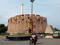
-
 Raghavendra Math Brundavanam at Mantralayam
 -

.jpg)

Achyutaraya who succeeded Krishnadevaraya built the initial Konda Reddy Fort between 1530 and 1542. The fort has different gateways and bastions. The fort is named after Konda Reddy, the last ruler of Alampur who was imprisoned in the fort by the Kurnool Nawab in the 17th century.[31] Mantralayam on the banks of the Tungabhadra River is famous for the devotees of Raghavendra Swamy, a saint who lived in the 17th century.[32]
Orvakal rock garden, at about 25 km from Kurnool is a natural landscape of regal rock formations.[33] Sanjeevaiah Sagar also known as The Gajuladinne Project is a dam on the Handri river situated about 20 km from Yemmiganur.[34]
Many attractions in adjacent Nandyal district such as Belum caves, Srisailam, Yaganti can be explored with Kurnool as base.
Notable people
[edit]Uyyalawada Narasimha Reddy fought against British East India company rule in India in 1847.[35] Damodaram Sanjivayya served as the first Dalit Chief Minister of united Andhra Pradesh. He also served as central minister later.[36] Kotla Vijaya Bhaskara Reddy represented several assembly constituencies of the undivided district during his political career. He rose to the position of Chief Minister of Andhra Pradesh and also became central minister.[37] P. S. Ramakrishna Rao directed and produced several Telugu films.[38]
References
[edit]- ^ https://kurnool.ap.gov.in/ [bare URL]
- ^ a b c d e f "Here's how new ap map looks after districts reorganisation". 3 April 2022. Retrieved 17 April 2023.
- ^ "Population". Census of India. Registrar General and Census Commissioner of India. Retrieved 12 June 2019.
- ^ Pavan (17 June 2022). "AP govt. issues orders recognising Urdu as the official language". The Hans India.
- ^ "New 'AP 39' code to register vehicles in Andhra Pradesh launched". The New Indian Express. Vijayawada. 31 January 2019. Archived from the original on 28 July 2019. Retrieved 9 June 2019.
- ^ a b c d e f g h i "District Census Hand Book – Kurnool" (PDF). Census of India. Registrar General and Census Commissioner of India.
- ^ "archelogical excavations" (PDF). aparchaeologymuseum. Archived from the original (PDF) on 17 December 2013. Retrieved 15 June 2014.
- ^ Michael Petraglia. "New rock art discoveries in the Kurnool District, Andhra Pradesh, India". academia.edu.
- ^ The Imperial Gazetteer of India, Volume 7. Oxford: Clarendon Press. 1908. pp. 158–76.
- ^ "Census of India Website : Office of the Registrar General & Census Commissioner, India" (PDF). www.censusindia.gov.in. Archived from the original (PDF) on 30 June 2014.
- ^ US Directorate of Intelligence. "Country Comparison:Population". Archived from the original on 13 June 2007. Retrieved 1 October 2011.
Liberia 3,786,764 July 2011 est.
- ^ "2010 Resident Population Data". U. S. Census Bureau. Archived from the original on 19 October 2013. Retrieved 30 September 2011.
Oregon 3,831,074
- ^ "Economy of Kurnool District". Andhra Pradesh Economic Development Board. Retrieved 25 April 2017.
- ^ "School Education Department" (PDF). School Education Department, Government of Andhra Pradesh. Archived from the original (PDF) on 27 December 2015. Retrieved 7 November 2016.
- ^ "The Department of School Education – Official AP State Government Portal". www.ap.gov.in. Archived from the original on 7 November 2016. Retrieved 7 November 2016.
- ^ "School Information Report". Commissionerate of School Education. Government of Andhra Pradesh. Archived from the original on 8 November 2016. Retrieved 8 November 2016.
- ^ "Student Information Report". Commissionerate of School Education. Child info 2015–16, District School Education – Andhra Pradesh. Archived from the original on 22 May 2015. Retrieved 8 November 2016.
- ^ "Population by Religion - Andhra Pradesh". censusindia.gov.in. Registrar General and Census Commissioner of India. 2011.
- ^ a b "Table C-16 Population by Mother Tongue: Andhra Pradesh". Census of India. Registrar General and Census Commissioner of India.
- ^ "New AP Map: Check Out Biggest and Smallest Districts in Andhra Pradesh". Sakshi Post. 3 April 2022. Archived from the original on 1 June 2022. Retrieved 3 May 2022.
- ^ "Part-I State Administrative Divisions 2001–2011" (PDF). Census of India. pp. 359–366. Retrieved 18 January 2015.
- ^ DOP (2023). Socio Economic Survey 2022-23 (PDF). Government of AP. p. 350. Archived from the original (PDF) on 28 March 2024. Retrieved 15 May 2023.
- ^ "District-wise Assembly-Constituencies". ceoandhra.nic.in.
- ^ "Map of district". Kurnool district. Retrieved 17 April 2023.
- ^ "Approval and Expenditure on Projects" (PDF). 11 August 2021. Retrieved 17 April 2023.
- ^ New Railways – New Andhra Pradesh (2014-21) (PDF). 2022.
- ^ "Y.S. Jagan Mohan Reddy inaugurates Kurnool airport, the sixth civilian airport in Andhra Pradesh". Frontline. 29 March 2021. Retrieved 15 May 2023.
- ^ "About RUK". Rayalaseemauniversity.ac.in. Retrieved 15 May 2023.
- ^ "Home page". kurnoolmedicalcollege.ac.in. Retrieved 15 May 2023.
- ^ "About IIITDM Kurnool". IIIT Kanchipuram. Retrieved 15 May 2023.
- ^ "KONDA REDDY BURUJU / KONDA REDDY FORT - TRAVEL INFO". Trawell.in. Retrieved 17 October 2018.
- ^ Eswaran, Arcot. "Mantralayam for that healing touch". The Hindu. No. 18 October 2002. The Hindu Newspaper. Archived from the original on 25 February 2003. Retrieved 11 March 2017.
- ^ "Orvakallu Haritha Hotel". aptourismhotels.in. Retrieved 15 May 2023.
- ^ "SANJEEVIAH SAGAR Gajuladinne Project". krmb.gov.in. Retrieved 15 May 2023.
- ^ Reddy, K. Venugopal (2010). "Dominance and Resistance: A Study of Narasimha Reddy's Revolt in Andhra against the injustice and towards India's freedom movement (1846–47)". Social Scientist. 38: 23–36. JSTOR 25621954.
- ^ "What's Under A Surname? Well, A Whole State". Outlook. 16 December 2013. Retrieved 25 October 2019.
- ^ August 2, India today digital (15 October 1982). "We can take NTR in our stride: Vijayabhaskara Reddy". India Today. India Today. Retrieved 13 February 2021.
{{cite news}}: CS1 maint: numeric names: authors list (link) - ^ "PS Ramakrishna Rao". nettv4u.com. Retrieved 15 May 2023.
External links
[edit]

- Official website

- Mandals of Kurnool district - Interactive Overpass-turbo OSM map
- Kurnool district railway network - Interactive Overpass-turbo OSM map
- Kurnool district national highway network - Interactive Overpass-turbo OSM map

Places adjacent to Kurnool district | |
|---|---|


Capital: Amaravati | |
| Topics | |
| Symbols |
|
| Regions | |
| Districts | |
| Metropolis | |
| Cities |
|
| Transport | |
| Tourism | |
| History | |
| Related lists | |
| District headquarters |  | |
|---|---|---|
| Divisions | ||
| Mandals | ||
| Cities | ||
| Towns | ||
| Census towns | ||
| International | |
|---|---|
| National | |
| Other | |
Kurnool district
View on GrokipediaEtymology
Origin and historical naming
The name of Kurnool district derives from the Telugu term Kandanavōlu or Kandanavolu, attested in ancient inscriptions and historical literature as the original designation for the region.[2][5] This etymology breaks down into kandana, denoting grease or lubricant in Telugu, and vōlu or volu, signifying a settlement or locale.[6][7] The term reflects the area's function as a key crossing point over the Tungabhadra River, where caravans and bullock carts halted to apply grease to axles before fording the waters, a practice common in pre-modern trade routes.[2][8] Historical records indicate this usage persisted through medieval periods, with the name gradually phoneticizing to Kurnool by the early modern era, as documented in regional Telugu sources.[5][9] Alternative derivations, such as from gadapa (gate) linking to northern access routes toward sacred sites, appear in some accounts but lack the inscriptional corroboration of Kandanavōlu.[10] No direct mythological ties to Puranic figures or early rulers are evidenced in primary epigraphic sources for the naming convention itself.[11]History
Ancient and medieval periods
Kurnool district preserves extensive evidence of prehistoric human activity, particularly in rock shelters, caves, and open sites associated with the Paleolithic and Neolithic periods. Sites such as the Kurnool Caves, including Billa Surgam, have yielded Paleolithic stone tools, bone implements, and faunal remains indicating early hominid occupation potentially dating back tens of thousands of years.[12] [13] The Ketavaram site, located 16 km southeast of Kurnool, represents a Neolithic settlement flourishing between approximately 10,000 and 5,000 BC, with artifacts underscoring early agricultural and pastoral practices in the region.[14] In 2018, archaeologists identified 145 rock shelters featuring prehistoric paintings in the Kunukuntala and Racherla areas, marking one of the largest such clusters in South India and depicting motifs like animals and human figures.[15] The Iron Age is evidenced by numerous megalithic burials across the district, including dolmens, cist chambers, and urn burials concentrated in valleys like Jurreru. Excavations at Chanugondla village uncovered Neolithic tools alongside megalithic structures such as dolmenoid cists, highlighting a continuum from prehistoric to protohistoric funerary practices involving black-and-red ware pottery and iron objects.[16] [17] These sites, distributed widely in Kurnool, reflect a megalithic culture prevalent from around 1200 BC to 300 BC, with port-hole cists and dolmens indicating hierarchical social structures and ritualistic burials.[18] By the 3rd century BC, during the Mauryan Empire, the region fell under imperial control, as attested by Emperor Ashoka's rock edicts at Yerragudi (also spelled Erragudi), near Gooty in Kurnool district. These inscriptions, in Prakrit using Brahmi script, include Major Rock Edicts 1, 2, 13, and 14, along with Minor Rock Edicts, propagating principles of Dhamma such as obedience to parents, respect for elders, and non-violence toward living beings.[19] [20] Additional Ashokan edicts appear at Jonnagiri, on granite hills, reinforcing Mauryan administrative reach into the Deccan.[3] Post-Mauryan rule transitioned to the Satavahanas around the 2nd century BC, who consolidated power in the Deccan and maintained stability against external threats. Archaeological layers at sites like Sathanikota in Kurnool district reveal Satavahana-era artifacts, including pottery and structural remains, linking the region to their broader Andhra kingdom that endured until the 3rd century AD.[21] In the medieval era, from the 12th to 16th centuries, Kurnool experienced successive dominion by the Chalukyas, Kakatiyas, and Vijayanagara Empire, serving as a strategic transit point on southern trade routes. The Kakatiyas, ruling in the 13th century, integrated the area into their Telugu-speaking domains following Chola influence.[22] Under Vijayanagara, particularly during Achyuta Deva Raya's reign (1529–1542 CE), fortifications like the Konda Reddy Buruju tower were erected as part of defensive bastions, exemplifying imperial military architecture amid regional conflicts.[23]Colonial and modern history up to independence
The territory of Kurnool came under direct British control in 1839 following the deposition of the last Nawab, who had ruled as a subordinate to the Nizam of Hyderabad, marking the end of local Muslim princely authority and integration into the Madras Presidency.[24] The British formalized the district's administration in 1858 as part of reorganizing the presidency's revenue divisions, imposing the Ryotwari system whereby land revenue was assessed and collected directly from individual cultivators to streamline taxation and fund colonial infrastructure.[24] This shift from jagirdari tenures to direct peasant assessment generated widespread agrarian discontent, as fixed assessments often exceeded fluctuating harvests, exacerbating famines and indebtedness in the semi-arid region.[25] Local resistance manifested in the 1846–1847 rebellion led by Uyyalawada Narasimha Reddy, a zamindar in the Koilkuntla area, who rallied thousands of ryots against the kattubadi intermediaries—revenue farmers appointed by the British—who enforced harsh collections and land alienations under the new system. British forces suppressed the uprising after several months of guerrilla warfare, executing Reddy in 1847, but it highlighted causal links between revenue policies and peasant mobilization, influencing later administrative caution in revenue hikes. To mitigate such volatility and boost agricultural output for revenue stability, the British initiated irrigation works, including the Kurnool-Cuddapah Canal constructed from 1863 to 1870, which diverted Tungabhadra waters to irrigate over 100,000 acres across Kurnool and adjacent districts, initially blending navigation with perennial cropping to support cotton and grain production.[26] By the early 20th century, Kurnool's elites engaged in the Indian National Congress, fostering anti-colonial sentiment amid World War II pressures. The 1942 Quit India Movement elicited strong local response, with the Kurnool District Congress Committee adopting resolutions on August 8 for mass non-cooperation and strikes against British rule, prompting arrests of leaders and disruptions to railways and government offices in towns like Adoni and Nandyal.[27] These actions, though quelled by repression, underscored the district's alignment with broader demands for self-rule, paving the way for independence in 1947 without further large-scale violence in the area.[28]Post-independence era and district evolution
Upon the linguistic reorganization of states, Andhra State was established on 1 October 1953 from the Telugu-speaking districts of Madras Presidency, with Kurnool designated as its capital city.[29] The selection of Kurnool stemmed from its central location and existing infrastructure from the princely era, prompting rapid construction of temporary administrative buildings completed within 40 days to house state functions.[30] During this period, the district served as the political and administrative hub, facilitating governance for the newly formed state's approximately 31 million residents across 11 districts.[31] The States Reorganisation Act of 1956 integrated Andhra State with the Telugu-speaking regions of Hyderabad State to create Andhra Pradesh on 1 November 1956, shifting the capital to Hyderabad and ending Kurnool's brief tenure as a state capital after exactly three years.[32] Kurnool district retained its territorial integrity within the new state, encompassing Rayalaseema's arid landscapes and focusing on agricultural and administrative consolidation, though no major boundary alterations occurred until later decades.[2] Administrative reforms in the 1980s, including the introduction of the mandal system under the Andhra Pradesh Mandal Praja Parishad Act, subdivided the district into smaller revenue units for decentralized governance, replacing earlier taluk structures with 50 mandals by the early 2000s to enhance local administration efficiency.[33] The Tungabhadra Dam's completion in October 1953, with masonry work finalized that year and full operations by 1957, provided critical irrigation to downstream command areas in Kurnool, irrigating over 500,000 acres in Andhra Pradesh portions and enabling double-cropping in previously rain-dependent zones.[34] This development boosted agricultural output, particularly for cotton, groundnut, and paddy, by stabilizing water supply from the river's 11,000 square kilometer catchment, mitigating drought risks in the district's semi-arid terrain. The Green Revolution's rollout in the mid-1960s amplified these gains through high-yielding seed varieties, synthetic fertilizers, and expanded canal networks, raising crop yields in Kurnool's irrigated belts by 20-30% for staples like rice and millets, though dryland farming in upland mandals experienced uneven adoption due to persistent water scarcity.[35] This period marked a shift toward mechanized farming and chemical inputs, contributing to a district-wide agricultural growth rate averaging 3-4% annually through the 1970s, driven by state extension services and cooperative credit, yet exacerbating soil degradation in over-fertilized areas.Recent administrative reorganizations
In April 2022, the Andhra Pradesh government restructured its districts from 13 to 26, splitting the erstwhile Kurnool district into residual Kurnool and newly formed Nandyal districts effective April 4.[36] This division carved out the Nandyal revenue division along with Dhone and Atmakur revenue divisions—encompassing 29 mandals—from the original district, leaving Kurnool with 26 mandals and its headquarters at Kurnool city.[37][38] The reorganization reduced the administrative burden on the residual district by decentralizing governance over a smaller area, facilitating quicker decision-making and service delivery in response to population distribution and logistical challenges in the larger pre-split entity.[39] The rationale emphasized enhancing efficiency in public administration, with smaller districts enabling better resource allocation and closer proximity between officials and remote populations, though critics noted potential overlaps in prior revenue divisions.[40] Post-reorganization, Kurnool district's structure stabilized with focused mandal-level oversight, contributing to streamlined local governance amid Andhra Pradesh's post-2014 bifurcation adjustments. As of October 2025, minor boundary tweaks remain under review via a state Group of Ministers addressing legacies of the 2022 changes, but no further district creations have been approved.[41] Public petitions, including demands to elevate Adoni—150 km from Kurnool headquarters—into a separate district for improved accessibility, continue to surface through rallies and ministerial consultations, yet official statements indicate prioritization of existing frameworks over expansion.[42][43]Geography
Physical features and location
 observatory in Kurnool. The predominant soil types include red ferruginous soils in upland regions, derived from weathered granite and gneiss, and black cotton soils (Vertisols) in lowland areas, characterized by high clay content and moderate to strong alkalinity. [51] Red soils, covering much of the district's plateau, exhibit low to medium organic carbon and nitrogen but support rainfed crops like groundnut and millets due to their drainage properties, while black soils, with better water retention, are highly suitable for cotton and pulses, though prone to cracking in dry periods.[52] Empirical soil surveys confirm these classifications, linking fertility status—low phosphorus in some red soil variants—to targeted agricultural practices for viability. Natural mineral resources feature significant barytes (barite) deposits, particularly bedded occurrences interlayered with chert in the Vempalle Formation of the Cuddapah Supergroup near Brahmanakotukuru, supporting industrial extraction.[53] These reserves contribute to the district's economic base, though extraction is limited compared to neighboring areas. The semi-arid conditions exacerbate drought frequency, with multiple moderately dry years recorded in mandals like Alur since the 2000s, alongside groundwater trends showing declines of 0.1 to 0.62 m/year in pre-monsoon periods per Central Ground Water Board assessments.[54] [49] Such depletion, observed in 22-36% of wells, underscores causal links between erratic rainfall and over-reliance on aquifers for irrigation, impacting soil moisture retention.[55]Rivers, water bodies, and hydrology
The Krishna River basin encompasses Kurnool district, where the Krishna forms portions of the district's northern and eastern boundaries, supporting major hydraulic infrastructure. The Tungabhadra River, the Krishna's largest tributary, originates in Karnataka and enters Andhra Pradesh at Kosigi in Kurnool district, flowing approximately 70 kilometers eastward before its confluence with the Krishna at Sangameswaram near Alampur; this merger creates a significant hydrological junction influencing downstream flows and sediment deposition.[56] The Srisailam Dam, constructed across the Krishna River in the Nallamala Hills within Kurnool district, impounds a reservoir with a gross storage capacity of 8,723 million cubic meters at full reservoir level, enabling multipurpose utilization for irrigation, hydropower, and flood control; the structure, completed in 1981, regulates seasonal inflows from an upstream catchment area exceeding 200,000 square kilometers.[57] The Handri-Neeva Sujala Sravanthi (HNSS) project extracts floodwater from the Srisailam reservoir's foreshore via a 4.8-kilometer approach channel and main canal system, facilitating lift irrigation across drought-prone upland areas; it targets stabilization of 602,500 acres (244,000 hectares) under kharif cropping in Kurnool and adjacent Rayalaseema districts through gravity-fed distribution networks.[58] Interstate water allocation for the Krishna, adjudicated by the Krishna Water Disputes Tribunal (KWDT-I, 1976), mandates Karnataka to release regulated flows benefiting Andhra Pradesh projects, including 10 thousand million cubic feet (TMC) annually for the Kurnool-Cuddapah Canal originating from Srisailam; Andhra Pradesh's total dependable share of 811 TMC at 75% reliability underpins reservoir operations in Kurnool, though ongoing disputes and KWDT-II proceedings (extended through 2025) have periodically constrained releases, exacerbating variability in downstream hydrology.[59][60] These allocations have enabled expansion of irrigated net sown area in the district from rainfed dominance to approximately one-third coverage via canal systems like Tungabhadra and Srisailam, measured against baseline pre-project extents.[61]Flora, fauna, and environmental concerns
Kurnool district's vegetation is characterized by tropical dry deciduous and tropical thorn forests, adapted to the region's semi-arid conditions with low rainfall.[62] Dominant tree species include Anogeissus latifolia, which exhibits high importance value index in surveyed areas, alongside families such as Fabaceae and Malvaceae contributing significantly to floristic diversity.[63] [64] Red sandalwood (Pterocarpus santalinus), a slow-growing endemic species valued for its timber, occurs in the district's eastern hills, though overexploitation has led to regulated harvesting under forest laws.[65] Wildlife habitats support herbivores like blackbucks (Antilope cervicapra), with populations exceeding 900 individuals in key areas, and predators including Indian wolves (Canis lupus pallipes), foxes, and jackals.[66] [67] Rollapadu Wildlife Sanctuary, established in 1988 over 6.14 km², primarily protects grassland ecosystems and hosts over 150 bird species, including large harrier roosts (Circus spp.).[68] [69] The district borders the Nallamala region of the Nagarjunsagar-Srisailam Tiger Reserve, facilitating occasional sightings of tigers (Panthera tigris) and sloth bears (Melursus ursinus), though core populations remain outside Kurnool's boundaries.[67] Environmental concerns stem from anthropogenic pressures, including fuelwood collection, agricultural expansion, and mining, which have historically fragmented habitats in the Yerramalai ranges.[70] Global Forest Watch data indicate a net gain of 2.55 kha (1.4%) in tree cover from 2000 to 2020, with stable forest at 186 kha, attributed to afforestation offsetting losses.[71] Despite this, conservation efficacy is limited; the critically endangered Great Indian Bustard (Ardeotis nigriceps) has vanished from Rollapadu due to habitat degradation and predation, highlighting gaps in protection despite sanctuary status.[72] Ongoing efforts focus on anti-poaching and habitat restoration, but illegal logging of red sandalwood persists as a causal driver of localized biodiversity loss.[73]Demographics
Population statistics and trends
According to adjusted 2011 census data following the 2022 district reorganization in Andhra Pradesh, Kurnool district has a total population of 2,271,686, comprising 1,142,000 males and 1,130,000 females.[33] The district spans 7,977 square kilometers, yielding a population density of approximately 285 persons per square kilometer.[74] Urban population constitutes about 34% of the total, concentrated in municipal areas like Kurnool city, with rural areas dominating due to the district's agrarian base.[33] The sex ratio stands at 988 females per 1,000 males, reflecting a slight female deficit compared to the state average, while the child sex ratio (ages 0-6) is 938, indicating persistent imbalances potentially linked to cultural preferences for male children.[75] Population growth in the pre-reorganization district averaged 14.65% decennially from 2001 to 2011, driven by natural increase and net in-migration, though post-2022 boundaries have apportioned these trends across new districts like Nandyal and Adoni, stabilizing reported figures for residual Kurnool without updated census data.[76] Migration patterns show rural-to-urban flows toward Kurnool city and nearby industrial hubs, motivated by limited agricultural yields and seasonal labor opportunities, contributing to urban density pressures despite overall low district urbanization.[77] Projections for 2023 estimate modest growth to around 2.27 million, assuming continued low fertility rates and out-migration to larger metros like Hyderabad, though official updates remain pending the next national census.[33]Linguistic and cultural composition
Telugu serves as the dominant language in Kurnool district, spoken as the mother tongue by approximately 80.13% of the population according to the 2011 Census of India.[78] This figure reflects the region's historical integration into Telugu-speaking territories under various dynasties and post-independence state formations, with the local variant belonging to the Rayalaseema dialect characterized by distinct phonetic shifts and vocabulary influenced by proximity to Kannada and Tamil linguistic zones. Urdu ranks as the second most spoken language, accounting for 15.21% of mother tongues, primarily among Muslim communities whose ancestors migrated during the medieval Deccan Sultanates and Nizam's rule in adjacent Hyderabad territories before 1948.[78] Kannada speakers constitute about 2.70%, linked to cross-border movements from neighboring Karnataka, while smaller minorities include Tamil (under 1%) from historical trade routes and settlements near the Tamil Nadu frontier.[78] These distributions underscore migration-driven linguistic diversity rather than indigenous origins for non-Telugu groups. Among Scheduled Tribes, the Yerukala community—estimated at significant numbers within Kurnool's tribal population—traditionally speaks Yerukala (also known as Kurru bhasha), a Dravidian language related to southern tongues like Irula and Tamil, though most speakers have transitioned to Telugu as a primary language due to intergenerational shifts. [79] Post-independence policies promoting education and economic integration have accelerated this assimilation, eroding distinct Yerukala linguistic features and cultural practices such as traditional kinship terminology, with limited formal preservation efforts amid broader Telugu dominance. Tribal groups like Yerukala exhibit partial cultural retention in rural enclaves through oral traditions, but urbanization and state-driven development have fostered hybrid identities blending tribal customs with mainstream Telugu agrarian and artisanal norms.[80]Religious and social demographics
According to the 2011 Census of India, Hindus constitute 82.11% of Kurnool district's population (3,328,380 individuals), forming an overwhelming majority, while Muslims account for 16.55% (670,737), Christians 0.82% (33,165), Sikhs 0.03% (1,106), Buddhists 0.02% (654), Jains 0.01% (541), and those not stating a religion 0.43% (17,520), with other religions negligible.[81] This distribution reflects historical patterns of settlement and conversion, with Muslim concentrations in urban areas like Kurnool city and Christian adherents often linked to missionary activities among lower castes.[75]| Religion | Percentage | Population (2011) |
|---|---|---|
| Hinduism | 82.11% | 3,328,380 |
| Islam | 16.55% | 670,737 |
| Christianity | 0.82% | 33,165 |
| Sikhism | 0.03% | 1,106 |
| Buddhism | 0.02% | 654 |
| Jainism | 0.01% | 541 |
| Not stated | 0.43% | 17,520 |
Literacy, health, and socio-economic metrics
As of the 2011 census, Kurnool district recorded a literacy rate of 59.97%, with males at 70.10% and females at 49.78%, reflecting a significant gender gap of over 20 percentage points and trailing the national average of 72.98%.[82] [83] This disparity persists in rural areas, where female literacy lags due to factors like early marriage and limited access to education, though no comprehensive post-2011 census data exists to quantify recent improvements.[1] Health outcomes in Kurnool remain challenged, with the infant mortality rate (IMR) at 43 per 1,000 live births, higher than the Andhra Pradesh state average of 39 and indicative of gaps in maternal and child healthcare access.[84] Groundwater contamination contributes to endemic fluorosis, as studies detect fluoride levels exceeding the Bureau of Indian Standards limit of 1.5 mg/L in over 57% of samples across the district, leading to dental and skeletal manifestations in affected populations reliant on borewells.[85] [86] Socio-economic metrics highlight persistent deprivation, with Kurnool registering the highest multidimensional poverty index (MPI) in Andhra Pradesh at 0.094 based on NFHS-5 data, encompassing deprivations in health, education, and living standards affecting a substantial rural majority.[87] Recent estimates place the poverty headcount ratio at 12.84%, underscoring inequality exacerbated by agrarian dependence and limited diversification, though state-level human development efforts have not yet closed regional gaps evident in lower literacy and health indicators.[88]| Indicator | Value | Source |
|---|---|---|
| Literacy Rate (2011) | 59.97% overall | Census 2011[82] |
| IMR (recent) | 43/1,000 live births | AP Health Dept.[84] |
| MPI (NFHS-5) | 0.094 | NITI Aayog survey[87] |
| Fluoride exceedance in groundwater | >57% samples | 2023 study[85] |