Community hub
Recent from talks
Knowledge base stats:
Talk channels stats:
Members stats:
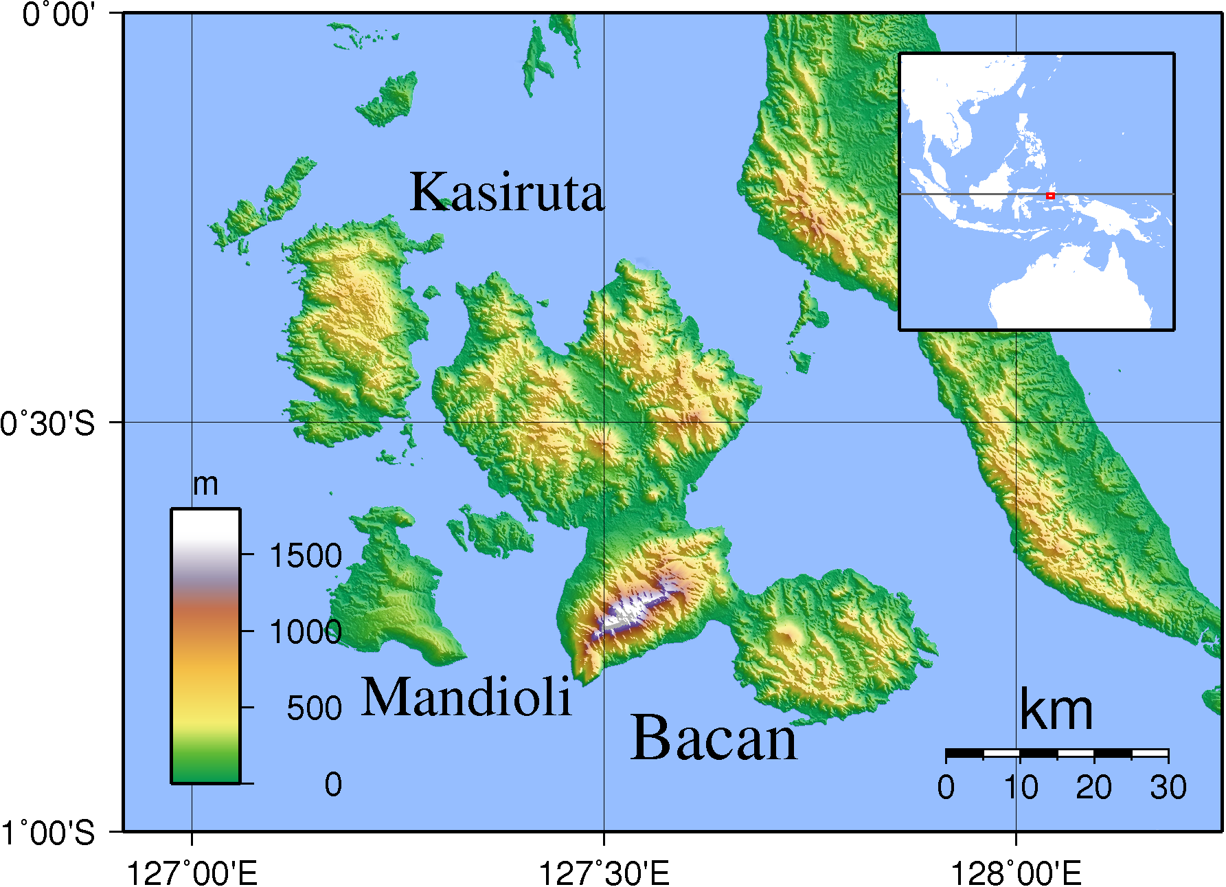
Bacan Islands
The Bacan Islands (Indonesian: Kepulauan Bacan; Indonesian pronunciation: [kəpuˌlawan ˈbat͡ʃan]), formerly also known as the Bachans, Bachians, and Batchians, are a group of islands in the Moluccas in Indonesia. They are mountainous and forested, lying south of Ternate and southwest of Halmahera. The islands are administered by the South Halmahera Regency of North Maluku Province. They formerly constituted the Sultanate of Bacan.
Bacan (Dutch: Batjan), formerly also known as Bachian or Batchian, is the group's largest island. Bacan Island in 2020 included about 82,387 people, of whom 7,073 lived in the capital Labuha; it is subdivided into seven districts. The second and third-largest islands are Kasiruta and Mandioli. Kasiruta and Mandioli each have over 11,000 inhabitants, and each is subdivided into two districts. A fourth island, Batang Lomang, forms a twelfth district within the group. There are dozens of smaller islands in the group, which had a total population of 84,075 at the 2010 Census, but by the 2020 Census had risen to 111,517. The official estimate as at mid-2023 was 117,986.
The group is divided into twelve administrative districts (kecamatan) out of the thirty districts within South Halmahera Regency. They are tabulated below with their areas and their populations at the 2010 Census and 2020 Census, together with the official estimate for mid 2023. The table also includes the number of administrative villages (all classed as rural desa) in each district and its post code.
Notes: (a) formally called Kepulauan Batanglomang; situated between Bacan and Mandioli Islands.
(b) except for Bobo desa, which has a postcode of 97792.
(c) includes Lata Lata Island (27.9 km2, with 1,201 inhabitants in 2020), located to the northwest of Kasiruta Island, and comprising two desa - Lata Lata and Sidanga.
Bacan Island's seven districts comprise 63 villages (desa) as follows: Bacan Timur Selatan - Liaro, Pigaraja, Silang, Tabajaya, Tabangame, Wayakuba and Wayaua. Batan Timur Tengah - Bibinoi, Songa, Tabapoma, Tawa, Tomara, Tutupa and Wayatim. Bacan Timur - Babang, Bori, Goro-Goro, Kaireu, Nyonyifi, Sabatang, Sali Kecil, Sayoang, Timlonga and Wayamiga. Bacan Selatan - Gandasuli, Kampung Makian, Kubung, Kupal, Mandaong, Panamboang, Papaloang, Sawadai, Tembal and Tuokona. Bacan (district) - Amasing Kali, Amasing Kota, Amasing Kota Barat, Amasing Kota Utara, Awanggoa, Belang Belang, Hidayat, Indomut, Kaputusan, Labuha, Marabose, Suma Tinggi, Sumae and Tomori. Bacan Barat Utara - Geti Baru, Geti Lama, Gilalang, Jojame, Lolarogurua, Nusa Babullah, Sidopo and Yaba. Bacan Barat - Indari, Kokotu, Kusubibi, Nang, Nondang, Tawabi and Wiring.
Batang Lomang's single district comprises 8 villages as follows: Bajo, Batutaga, Kampung Baru, Paisumbaos, Prapakanda, Sawangakar, Tanjung Obit and Toin.
Mandioli's two districts comprise 12 villages as follows: Mandioli Selatan - Bahu, Galala, Jiko, Lele, Tabalema and Yoyok. Mandioli Utara - Akedabo, Bobo, Indong, Leleongusu, Pelita and Waya.
Kasiruta's two districts comprise 18 villages, listed as follows with their populations in mid 2022: Kasirutu Barat - Kakupang (493), Marikapal (255), Bisori (671), Doko (809), Palamea (763), Arumamang (742), Lata Lata (640), Sidanga (631), Sengga Baru (455) and Imbu Imbu (437). Kasirutu Timur - Tawa Bacan Barat (639), Maritosa (893), Loleo Jaya (1,439), Kou Balabala (593), Loleo Mekar (437), Kasiruta Dalam (552), Jeret (374) and Tutuhu (262).
From early times, Bacan was one of the four kingdoms of Maluku together with Ternate, Tidore and Jailolo. The ruling elite converted to Islam in about the late 15th century. The sultan at first resided on Kasiruta Island and had political and commercial influence in northern Ceram and the Papuan Islands. In 1513, the first Portuguese trading fleet to reach the Moluccas set up a trading post on Bacan which at the time was tied to the Sultan of Ternate by dynastic marriages. The fleet's commander, Captain Antonio de Miranda Azevedo, left seven men on Bacan to buy cloves for the following year's expedition. Their arrogant behaviour and reported bad treatment of Bacan women led to their murder. As Ternate did not have enough stock, the ship for which the men had stayed to prepare was used by the Sultan of Ternate to fill Ferdinand Magellan's last ship, which was the first ship to circumnavigate the world. A slave and two birds of paradise were given to the ship by Bacan. Bacan became a place of refuge for rebellious Ternatans. The Portuguese sent a punitive expedition against Bacan but it failed, and instead the Portuguese Governor Galvão challenged Bacan's sultan to a duel to determine who was to be subservient to whom. The challenge was accepted but the duel never took place.
In 1557, Father Antonio Vaz converted Bacan's sultan and court members to Catholicism. The king was married to a daughter of Sultan Hairun of Ternate. Fleets from Ternate invaded the islands in 1570 and later and the king apostatized in 1575, though he was nevertheless poisoned in 1578. A community of Christians remained and were later joined by coreligionists from Tobelo and Ambon. A small Roman Catholic hospital was built by an elderly Dutch nun. Today, Protestants significantly outnumber Catholics. During the mid-19th century Moluccan travels of British naturalist Alfred Russel Wallace, Christians in the Moluccas were called Orang Sirani (lit. "Nazarene People"), a term regularly applied to locals of European ancestry in the Malay Archipelago, thought to have been descended from the Portuguese. They had dressed in white and black and Wallace reports they dance "quadrilles, waltzes, polkas, and mazurkas with great vigour and much skill".
Following the 1575 Ternatan invasion, Bacan become subservient to Ternate for periods, which was sealed through marriages. A sister and a daughter of Sultan Saidi Berkat of Ternate married Bacan rulers in the late 16th and early 17th centuries. A Spanish fort was built in 1606. By this time the seat of the sultan had been moved from Kasiruta to Bacan Island. Once the Dutch East India Company established hegemony in 1609, the Netherlands' power on Bacan was based in Fort Barnaveld.
Hub AI
Bacan Islands AI simulator
(@Bacan Islands_simulator)
Bacan Islands
The Bacan Islands (Indonesian: Kepulauan Bacan; Indonesian pronunciation: [kəpuˌlawan ˈbat͡ʃan]), formerly also known as the Bachans, Bachians, and Batchians, are a group of islands in the Moluccas in Indonesia. They are mountainous and forested, lying south of Ternate and southwest of Halmahera. The islands are administered by the South Halmahera Regency of North Maluku Province. They formerly constituted the Sultanate of Bacan.
Bacan (Dutch: Batjan), formerly also known as Bachian or Batchian, is the group's largest island. Bacan Island in 2020 included about 82,387 people, of whom 7,073 lived in the capital Labuha; it is subdivided into seven districts. The second and third-largest islands are Kasiruta and Mandioli. Kasiruta and Mandioli each have over 11,000 inhabitants, and each is subdivided into two districts. A fourth island, Batang Lomang, forms a twelfth district within the group. There are dozens of smaller islands in the group, which had a total population of 84,075 at the 2010 Census, but by the 2020 Census had risen to 111,517. The official estimate as at mid-2023 was 117,986.
The group is divided into twelve administrative districts (kecamatan) out of the thirty districts within South Halmahera Regency. They are tabulated below with their areas and their populations at the 2010 Census and 2020 Census, together with the official estimate for mid 2023. The table also includes the number of administrative villages (all classed as rural desa) in each district and its post code.
Notes: (a) formally called Kepulauan Batanglomang; situated between Bacan and Mandioli Islands.
(b) except for Bobo desa, which has a postcode of 97792.
(c) includes Lata Lata Island (27.9 km2, with 1,201 inhabitants in 2020), located to the northwest of Kasiruta Island, and comprising two desa - Lata Lata and Sidanga.
Bacan Island's seven districts comprise 63 villages (desa) as follows: Bacan Timur Selatan - Liaro, Pigaraja, Silang, Tabajaya, Tabangame, Wayakuba and Wayaua. Batan Timur Tengah - Bibinoi, Songa, Tabapoma, Tawa, Tomara, Tutupa and Wayatim. Bacan Timur - Babang, Bori, Goro-Goro, Kaireu, Nyonyifi, Sabatang, Sali Kecil, Sayoang, Timlonga and Wayamiga. Bacan Selatan - Gandasuli, Kampung Makian, Kubung, Kupal, Mandaong, Panamboang, Papaloang, Sawadai, Tembal and Tuokona. Bacan (district) - Amasing Kali, Amasing Kota, Amasing Kota Barat, Amasing Kota Utara, Awanggoa, Belang Belang, Hidayat, Indomut, Kaputusan, Labuha, Marabose, Suma Tinggi, Sumae and Tomori. Bacan Barat Utara - Geti Baru, Geti Lama, Gilalang, Jojame, Lolarogurua, Nusa Babullah, Sidopo and Yaba. Bacan Barat - Indari, Kokotu, Kusubibi, Nang, Nondang, Tawabi and Wiring.
Batang Lomang's single district comprises 8 villages as follows: Bajo, Batutaga, Kampung Baru, Paisumbaos, Prapakanda, Sawangakar, Tanjung Obit and Toin.
Mandioli's two districts comprise 12 villages as follows: Mandioli Selatan - Bahu, Galala, Jiko, Lele, Tabalema and Yoyok. Mandioli Utara - Akedabo, Bobo, Indong, Leleongusu, Pelita and Waya.
Kasiruta's two districts comprise 18 villages, listed as follows with their populations in mid 2022: Kasirutu Barat - Kakupang (493), Marikapal (255), Bisori (671), Doko (809), Palamea (763), Arumamang (742), Lata Lata (640), Sidanga (631), Sengga Baru (455) and Imbu Imbu (437). Kasirutu Timur - Tawa Bacan Barat (639), Maritosa (893), Loleo Jaya (1,439), Kou Balabala (593), Loleo Mekar (437), Kasiruta Dalam (552), Jeret (374) and Tutuhu (262).
From early times, Bacan was one of the four kingdoms of Maluku together with Ternate, Tidore and Jailolo. The ruling elite converted to Islam in about the late 15th century. The sultan at first resided on Kasiruta Island and had political and commercial influence in northern Ceram and the Papuan Islands. In 1513, the first Portuguese trading fleet to reach the Moluccas set up a trading post on Bacan which at the time was tied to the Sultan of Ternate by dynastic marriages. The fleet's commander, Captain Antonio de Miranda Azevedo, left seven men on Bacan to buy cloves for the following year's expedition. Their arrogant behaviour and reported bad treatment of Bacan women led to their murder. As Ternate did not have enough stock, the ship for which the men had stayed to prepare was used by the Sultan of Ternate to fill Ferdinand Magellan's last ship, which was the first ship to circumnavigate the world. A slave and two birds of paradise were given to the ship by Bacan. Bacan became a place of refuge for rebellious Ternatans. The Portuguese sent a punitive expedition against Bacan but it failed, and instead the Portuguese Governor Galvão challenged Bacan's sultan to a duel to determine who was to be subservient to whom. The challenge was accepted but the duel never took place.
In 1557, Father Antonio Vaz converted Bacan's sultan and court members to Catholicism. The king was married to a daughter of Sultan Hairun of Ternate. Fleets from Ternate invaded the islands in 1570 and later and the king apostatized in 1575, though he was nevertheless poisoned in 1578. A community of Christians remained and were later joined by coreligionists from Tobelo and Ambon. A small Roman Catholic hospital was built by an elderly Dutch nun. Today, Protestants significantly outnumber Catholics. During the mid-19th century Moluccan travels of British naturalist Alfred Russel Wallace, Christians in the Moluccas were called Orang Sirani (lit. "Nazarene People"), a term regularly applied to locals of European ancestry in the Malay Archipelago, thought to have been descended from the Portuguese. They had dressed in white and black and Wallace reports they dance "quadrilles, waltzes, polkas, and mazurkas with great vigour and much skill".
Following the 1575 Ternatan invasion, Bacan become subservient to Ternate for periods, which was sealed through marriages. A sister and a daughter of Sultan Saidi Berkat of Ternate married Bacan rulers in the late 16th and early 17th centuries. A Spanish fort was built in 1606. By this time the seat of the sultan had been moved from Kasiruta to Bacan Island. Once the Dutch East India Company established hegemony in 1609, the Netherlands' power on Bacan was based in Fort Barnaveld.