
Community hub
Recent from talks
Contribute something
Nothing was collected or created yet.
Air traffic control
View on Wikipedia

Air traffic control (ATC) is a service provided by ground-based air traffic controllers who direct aircraft on the ground and through controlled airspace. The primary purpose of ATC is to prevent collisions, organise and expedite the flow of air traffic, and provide information and other support for pilots.[1] In some countries, ATC can also provide advisory services to aircraft in non-controlled airspace. Controllers monitor the location of aircraft in their assigned airspace using radar and communicate with pilots by radio.[2] To prevent collisions, ATC enforces traffic separation rules, which ensure each aircraft maintains a minimum amount of empty space around it. ATC services are provided to all types of aircraft, including private, military, and commercial flights.[3] Depending on the type of flight and the class of airspace, ATC may issue mandatory instructions or non-binding advisories (known as flight information in some countries). While pilots are required to obey all ATC instructions, the pilot in command of an aircraft always retains final authority for its safe operation. In an emergency, the pilot may deviate from ATC instructions to the extent required to maintain the safety of the aircraft.[4] Weather conditions, such as thunderstorms, strong winds, and low visibility, can significantly affect air traffic control operations, leading to delays, diversions, and the need for alternate routing.[5]
Language
[edit]Pursuant to requirements of the International Civil Aviation Organization (ICAO), ATC operations are conducted either in the English language, or the local language used by the station on the ground.[6] In practice, the native language for a region is used; however, English must be used upon request.[6]
History
[edit]In 1920, Croydon Airport near London, England, was the first airport in the world to introduce air traffic control.[7] The 'aerodrome control tower' was a wooden hut 15 feet (5 metres) high with windows on all four sides. It was commissioned on 25 February 1920, and provided basic traffic, weather, and location information to pilots.[8][9]
In the United States, air traffic control developed three divisions. The first of several air mail radio stations (AMRS) was created in 1922, after World War I, when the U.S. Post Office began using techniques developed by the U.S. Army to direct and track the movements of reconnaissance aircraft. Over time, the AMRS morphed into flight service stations. Today's flight service stations do not issue control instructions, but provide pilots with many other flight related informational services. They do relay control instructions from ATC in areas where flight service is the only facility with radio or phone coverage. The first airport traffic control tower, regulating arrivals, departures, and surface movement of aircraft in the US at a specific airport, opened in Cleveland in 1930. Approach- and departure-control facilities were created after adoption of radar in the 1950s to monitor and control the busy airspace around larger airports. The first air route traffic control center (ARTCC), which directs the movement of aircraft between departure and destination, was opened in Newark in 1935, followed in 1936 by Chicago and Cleveland.[10]
After the 1956 Grand Canyon mid-air collision, killing all 128 on board, the FAA was given the air-traffic responsibility in the United States in 1958, and this was followed by other countries. In 1960, Britain, France, Germany, and the Benelux countries set up Eurocontrol, intending to merge their airspaces. The first and only attempt to pool controllers between countries is the Maastricht Upper Area Control Centre (MUAC), founded in 1972 by Eurocontrol, and covering Belgium, Luxembourg, the Netherlands, and north-western Germany. In 2001, the European Union (EU) aimed to create a 'Single European Sky', hoping to boost efficiency and gain economies of scale.[11]
In the USSR, the first air traffic control service was organized in 1929 on the Moscow - Irkutsk air route; in 1930, control areas were defined along all existing air routes.[12]
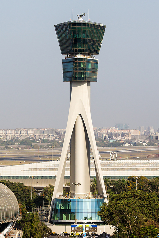
Airport traffic control tower
[edit]


The primary method of controlling the immediate airport environment is visual observation from the airport control tower. The tower is typically a tall, windowed structure, located within the airport grounds. The air traffic controllers, usually abbreviated 'controller', are responsible for separation and efficient movement of aircraft and vehicles operating on the taxiways and runways of the airport itself, and aircraft in the air near the airport, generally 5 to 10 nautical miles (9 to 19 kilometres; 6 to 12 miles), depending on the airport procedures. A controller must carry out the job using the precise and effective application of rules and procedures; however, they need flexible adjustments according to differing circumstances, often under time pressure.[13] In a study which compared stress in the general population and among staff working in this kind of system, there was markedly showed more stress level for controllers. This variation can be explained, at least in part, by the characteristics of the job.[14]
Remote and virtual tower (RVT) is a system based on air traffic controllers being located somewhere other than at the local airport tower, and still able to provide air traffic control services.[15][16][17]
Ground control
[edit].jpg)
Ground control (sometimes known as ground movement control, GMC) is responsible for the airport movement areas.[18]
Some busier airports have surface movement radar (SMR).[18]
Air control or local control
[edit]Air control (known to pilots as tower or tower control) is responsible for the active runway surfaces.[18]
Flight data and clearance delivery
[edit]Clearance delivery is the position that issues route clearances to aircraft, typically before they commence taxiing. These clearances contain details of the route that the aircraft is expected to fly after departure.[18]
Analogous use
[edit]In the field of supply chain management, the concept of a "supply chain control tower" reflects the "end-to-end visibility" provided by an air traffic control tower.[19] Ashutoch Gupta, writing for Gartner, observes that a supply chain control tower can be established "by combining people, process, data, organization and technology to improve visibility, control and decision making".[20]
Approach and terminal control
[edit]
In the U.S., TRACONs are additionally designated by a three-digit alphanumeric code. For example, the Chicago TRACON is designated C90.[21]
Area control centre / en-route centre
[edit]
An area control center, as opposed to a terminal control center, is a specific type of air traffic control center that primarily controls IFR traffic, or aircraft at high altitude flying by instruments, instead of aircraft that are landing or taking off.[22] Each area control center is assigned a flight information region, and certain area control centers near the coast are also tasked with monitoring aircraft flying over the ocean.[22] Area control centers perform similar duties to other types of air traffic control, such as rerouting aircraft to deal with adverse conditions and directing the course of aircraft to ensure separation.
Radar coverage
[edit]
In the past, data on the position of aircraft were mainly determined by the following types of radar:
- En-route radar with a coverage up to 240 NM (460 km)
- Airport surveillance radar, with a coverage up to of 52 NM (96 km) of the airport below an elevation of 25,000 feet
- Surface movement radar with a coverage of the airport surface, within 2 NM (3.7 km)
- Secondary surveillance radar with a coverage within line-of-sight range


In addition to such types of radar, some air navigation service providers (e.g., Airservices Australia, the U.S. Federal Aviation Administration, Nav Canada, etc.) have implemented automatic dependent surveillance – broadcast (ADS-B) as part of their surveillance capability. This newer technology reverses the radar concept. Instead of radar 'finding' a target by interrogating the transponder, the ADS-B equipped aircraft 'broadcasts' a position report as determined by the navigation equipment on board the aircraft. ADS-C is another mode of automatic dependent surveillance, however ADS-C operates in the 'contract' mode, where the aircraft reports a position, automatically or initiated by the pilot, based on a predetermined time interval. It is also possible for controllers to request more frequent reports to more quickly establish aircraft position for specific reasons.[23] However, since the cost for each report is charged by the ADS service providers to the company operating the aircraft,[disputed – discuss] more frequent reports are not commonly requested, except in emergency situations. ADS-C is significant, because it can be used where it is not possible to locate the infrastructure for a radar system (e.g., over water). Computerised radar displays are now being designed to accept ADS-C inputs as part of their display.[24][verification needed]
A radar archive system (RAS) keeps an electronic record of all radar information, preserving it for a few weeks. This information can be useful for search and rescue. When an aircraft has 'disappeared' from radar screens, a controller can review the last radar returns from the aircraft to determine its likely position. For an example, see the crash report in the following citation.[25]
Problems
[edit]Traffic
[edit]
Air traffic control errors occur when the separation (either vertical or horizontal) between airborne aircraft falls below the minimum prescribed separation set (for the domestic United States) by the US Federal Aviation Administration. Separation minimums for terminal control areas (TCAs) around airports are lower than en-route standards. Errors generally occur during periods following times of intense activity, when controllers tend to relax and overlook the presence of traffic and conditions that lead to loss of minimum separation.[26][text–source integrity?]
Weather
[edit]
According to the Civil Air Navigation Services Organisation (CANSO), weather significantly impacts global aviation, with more than 70% of air traffic delays being attributed to adverse weather conditions. These disruptions cause widespread delays, rerouting by ATC, and cancellations across continents. In 2024, Europe experienced a 40% increase in weather-related en-route delays compared to 2023. As increasingly adverse weather intensifies the frequency and severity of these events, CANSO urged collaboration and real-time solutions among global aviation stakeholders to mitigate the effects of weather on flight operations.[27]
Infrastructure
[edit]Global ATC infrastructure is a complex network that varies significantly by region, with many countries facing challenges related to outdated technology, staffing shortages, and increasing traffic demand. While some regions, like parts of Europe and the U.S., have implemented modernization programs such as SESAR and NextGen,[28] many others, especially in developing nations, still rely on legacy radar systems and voice-based communication, which limit efficiency and safety. These disparities contribute to delays and reduce the overall resilience of global air traffic management. According to the ICAO, coordinating ATC systems and accelerating digitalization is essential for meeting future aviation demands.[29] Similarly, a 2024 report from the International Air Transport Association (IATA) emphasizes the urgency of investing in scalable, data-driven infrastructure to handle post-pandemic growth and ensure sustainability across the network.[30]
Congestion
[edit]Constrained control capacity and growing traffic lead to flight cancellation and delays.[31][32]
- In America, delays caused by ATC grew by 69% between 2012 and 2017.[11] ATC staffing issues were a major factor in congestion.[33]
By then the market for air-traffic services was worth $14bn. More efficient ATC could save 5-10% of aviation fuel by avoiding holding patterns and indirect airways.[11]
The military takes 80% of Chinese airspace, congesting the thin corridors open to airliners. The United Kingdom closes its military airspace only during military exercises.[11]
Call signs
[edit]A prerequisite to safe air traffic separation is the assignment and use of distinctive call signs. These are permanently allocated by ICAO on request, usually to scheduled flights, and some air forces and other military services for military flights. There are written call signs with a two or three letter combination followed by the flight number such as AAL872 or VLG1011. As such, they appear on flight plans and ATC radar labels. There are also the audio or radio-telephony call signs used on the radio contact between pilots and air traffic control. These are not always identical to their written counterparts. An example of an audio call sign would be 'Speedbird 832', instead of the written 'BAW832'. This is used to reduce the chance of confusion between ATC and the aircraft. By default, the call sign for any other flight is the registration number (or tail number in US parlance) of the aircraft, such as 'N12345', 'C-GABC', or 'EC-IZD'. The short radio-telephony call signs for these tail numbers is the last three letters using the NATO phonetic alphabet (e.g. ABC, spoken alpha-bravo-charlie for C-GABC), or the last three numbers (e.g. three-four-five for N12345). In the United States, the prefix may be an aircraft type, model, or manufacturer in place of the first registration character, for example, 'N11842' could become 'Cessna 842'.[34]
Technology
[edit]The Federal Aviation Administration (FAA) has spent over US$3 billion on software, but a fully automated system is still yet to be achieved. In 2002, the United Kingdom commissioned a new area control centre into service at the London Area Control Centre (LACC) at Swanwick in Hampshire, relieving a busy suburban centre at West Drayton in Middlesex, north of London Heathrow Airport. Software from Lockheed-Martin predominates at the London Area Control Centre. However, the centre was initially troubled by software and communications problems causing delays and occasional shutdowns.[35]
Some tools are available in different domains to help the controller further:
- Flight data processing systems: this is the system (usually one per centre) that processes all the information related to the flight (the flight plan), typically in the time horizon from gate to gate (airport departure / arrival gates). It uses such processed information to invoke other flight plan related tools (such as e.g. Medium Term Conflict Detection (MTCD)).[36]
- Short-term conflict alert (STCA) that checks possible conflicting trajectories in a time horizon of about two or three minutes (or even less in approach context; 35 seconds in the French Roissy & Orly approach centres).[37]
- Center TRACON automation system (CTAS): a suite of human centred decision support tools developed by NASA Ames Research Center. Several of the CTAS tools have been field tested and transitioned to the FAA for operational evaluation and use. Some of the CTAS tools are: traffic management advisor (TMA), passive final approach spacing tool (pFAST), collaborative arrival planning (CAP), direct-to (D2), en route descent advisor (EDA), and multi-center TMA. The software is running on Linux.[38]
- MTCD and URET:
- In Europe, several MTCD tools are available: iFACTS (National Air Traffic Services), VAFORIT (Deutsche Flugsicherung), new FDPS (Maastricht Upper Area Control). The Single European Sky ATM Research (SESAR).[39]

- The Nav Canada system known as EXCDS.[40]
- Screen content recording: hardware or software based recording function which is part of most modern automation system, and that captures the screen content shown to the ATCO. Such recordings are used for a later replay together with audio recording for investigations and post event analysis.[41]
- Communication navigation surveillance / air traffic management (CNS / ATM) systems are communications, navigation, and surveillance systems, employing digital technologies, including satellite systems, together with various levels of automation, applied in support of a seamless global air traffic management system.[42]
Air navigation service providers (ANSPs) and air traffic service providers (ATSPs)
[edit]- Albania – Agjencia Nacionale e Trafikut Ajror
- Angola - Empresa Nacional de Navegação Aérea (ENNA)
- Armenia – Armenian Air Traffic Services (ARMATS)
- Australia – Airservices Australia (state agency) and Royal Australian Air Force.
- Austria – Austro Control
- Belgium – Skeyes (Successor of Belgocontrol)
- Brazil – Departamento de Controle de Tráfego Aéreo (military) und ANAC – Agência Nacional de Aviação Civil
- Bulgaria – Air Traffic Services Authority
- Canada – NAV CANADA
- Central America – Corporación Centroamericana de Servicios de Navegación Aerea
- Columbia – Aeronáutica Civil Colombiana
- Costa Rica – Dirección General de Aviacion Civil
- Croatia – Hrvatska kontrola zračne plovidbe (Croatia Control Ltd.)
- Cuba – IACC (Instituto de Aeronáutica Civil de Cuba)
- Czech Republic – Řízení letového provozu ČR
- Denmark – Naviair
- Dominican Republck – DGAC (Dirección General de Aeronáutica Civil)
- Estland – Lennuliiklusteeninduse
- European Union – Eurocontrol – (European Organisation for the Safety of Air Navigation)
- Finland – Finavia
- France – Direction des Services de la Navigation Aérienne (DSNA), part of Direction générale de l’aviation civile: (state-owned)
- Georgia – SAKAERONAVIGATSIA, Ltd. (Georgian Air Navigation)
- Germany – DFS Deutsche Flugsicherung GmbH (state-owned); DFS Aviation Services GmbH (DAS – affiliate of DFS); Rhein-Neckar Flugplatz GmbH (Mannheim Airport); AustroControl (at some regional airports)
- Greece – Hellenic Civil Aviation Authority (HCAA)
- Guatemala – DGAC (Dirección General de Aeronáutica Civil)
- Hongkong – CAD (state-owned)
- Hungary – HungaroControl Magyar Légiforgalmi Szolgálat Zrt. (HungaroControl Hungarian Air Navigation Services Pte. Ltd. Co.)
- India – Airports Authority of India (AAI) (department of ministry of civil aviation)
- Indonesia – Angkasa Pura II
- Ireland – AirNav Ireland
- Island – ISAVIA
- Italia – ENAV (state-owned)
- Jamaica – JCAA (Jamaica Civil Aviation Authority)
- Kenia - Kenya Civil Aviation Authority (KCAA)
- Latvia – (Latvian ATC)
- Lithuania – ANS (Lithuanian ATC)
- Luxemburg – Administration de la navigation aérienne (state-owned)
- Macedonia – DGCA (Macedonian ATC)
- Malaysia – DCA-Department of Civil Aviation
- Malta – Malta Air Traffic Services Ltd
- Mexico – Servicios a la Navegación en el Espacio Aéreo Mexicano
- Nepal – Civil Aviation Authority of Nepal
- Netherlands – Luchtverkeersleiding Nederland (LVNL)
- New Zealand – Airways New Zealand (staatliches Unternehmen)
- Norway – Avinor (Privatunternehmen im Staatsbesitz)
- Pakistan – Civil Aviation Authority of Pakistan (state-owned)
- Peru – Centro de Instrucción de Aviación Civil CIAC, Civil Aviation Training Center
- Philippines – Civil Aviation Authority of the Philippines (CAAP) (state-owned)
- Poland – PANSA – Polish Air Navigation Services Agency
- Portugal – NAV – (Portuguese ATC)
- Rumania – Romanian Air Traffic Services Administration – (ROMATSA)
- Russia – Federal State Unitary Enterprise – (State ATM Corporation)
- Saudi-Arabia – General Authority of Civil Aviation (GACA)
- Serbia – Serbia and Montenegro Air Traffic Services Agency Ltd. (SMATSA)
- Singapore – CAAS (Civil Aviation Authority of Singapore)
- Slovakia – Letové prevádzkové služby Slovenskej republiky
- Slovenia – Slovenia Control
- South Africa – Air Traffic and Navigation Services
- Spain – ENAIRE
- Sweden – The LFV Group (Swedish ATC)
- Switzerland – Skyguide
- Taiwan – ANWS Civil Aeronautical Administration
- Tanzania - Tanzania Civil Aviation Authority (TCAA)
- Thailand – AEROTHAI (Aeronautical Radio of Thailand)
- Trinidad and Tobago – TTCAA (Trinidad and Tobago Civil Aviation Authority)
- Turkey – DGCA (Turkish Directorate General of Civil Aviation)
- Ukraine – Ukrainian State Air Traffic Service Enterprise (UkSATSE)
- United Arab Emirates – General Civil Aviation Authority (GCAA)
- United Kingdom – National Air Traffic Services (Public Private Partnership)
- United States – Federal Aviation Administration (state-owned)
- Venezuela – INAC (Instituto Nacional de Aviación Civil)
- Vietnam – Vietnam Air Traffic Management Corporation (VATM)
- Zambia – Zambia Civil Aviation Authority (ZCAA)
- Zimbabwe – Zimbabwe Civil Aviation Authority
Proposed changes
[edit]In the United States, some alterations to traffic control procedures are being examined:
- Free flight is a developing air traffic control method that uses no centralised control (e.g. air traffic controllers). Instead, parts of airspace are reserved dynamically and automatically in a distributed way using computer communication to ensure the required separation between aircraft.[43]
In Europe, the Single European Sky ATM Research (SESAR)[39] programme plans to develop new methods, technologies, procedures, and systems to accommodate future (2020 and beyond) air traffic needs. In October 2018, European controller unions dismissed setting targets to improve ATC as "a waste of time and effort", as new technology could cut costs for users but threaten their jobs. In April 2019, the EU called for a 'Digital European Sky', focusing on cutting costs by including a common digitisation standard, and allowing controllers to move to where they are needed instead of merging national ATCs, as it would not solve all problems. Single air-traffic control services in continent-sized America and China does not alleviate congestion. Eurocontrol tries to reduce delays by diverting flights to less busy routes: flight paths across Europe were redesigned to accommodate the new airport in Istanbul, which opened in April, but the extra capacity will be absorbed by rising demand for air travel.[11]
Well-paid jobs in western Europe could move east with cheaper labour. The average Spanish controller earn over €200,000 a year, over seven times the country average salary, more than pilots, and at least ten controllers were paid over €810,000 ($1.1m) a year in 2010. French controllers spent a cumulative nine months on strike between 2004 and 2016.[11]
Privatisation
[edit]Many countries have also privatised or corporatised their air navigation service providers.[44] There are several models that can be used for ATC service providers. The first is to have the ATC services be part of a government agency as is currently the case in the United States. The problem with this model is that funding can be inconsistent, and can disrupt the development and operation of services. Sometimes funding can disappear when lawmakers cannot approve budgets in time. Both proponents and opponents of privatisation recognise that stable funding is one of the major factors for successful upgrades of ATC infrastructure. Some of the funding issues include sequestration and politicisation of projects.[45] Proponents argue that moving ATC services to a private corporation could stabilise funding over the long term which will result in more predictable planning and rollout of new technology as well as training of personnel.[citation needed] As of November 2024, The United States had 265 contractor towers that are staffed by private companies but administered by FAA through its FAA Contract Tower Program, which was established in 1982. These contract control towers cover 51% of all the Federal air traffic control towers in the U.S.[46]
Another model is to have ATC services provided by a government corporation. This model is used in Germany, where funding is obtained through user fees. Yet another model is to have a for-profit corporation operate ATC services. This is the model used in the United Kingdom, but there have been several issues with the system there, including a large-scale failure in December 2014 which caused delays and cancellations and has been attributed to cost-cutting measures put in place by this corporation. In fact, earlier that year, the corporation owned by the German government won the bid to provide ATC services for Gatwick Airport in the United Kingdom.[citation needed] The last model, which is often the suggested model for the United States to transition to is to have a non-profit organisation that would handle ATC services as is used in Canada.[47]
The Canadian system is the one most often used as a model by proponents of privatisation. Air traffic control privatisation has been successful in Canada with the creation of Nav Canada, a private non-profit organisation which has reduced costs, and has allowed new technologies to be deployed faster due to the elimination of much of the bureaucratic red tape. This has resulted in shorter flights and less fuel usage. It has also resulted in flights being safer due to new technology. Nav Canada is funded from fees that are collected from the airlines based on the weight of the aircraft and the distance flown.[48]
Air traffic control is operated by national governments with few exceptions: in the European Union, only Italy has private shareholders.[11] Privatisation does not guarantee lower prices: the profit margin of MUAC was 70% in 2017, as there is no competition, but governments could offer fixed terms concessions.[11]
ATC regulations in the United States
[edit]The United States airspace is divided into 21 zones (centres), and each zone is divided into sectors. Also within each zone are portions of airspace, about 50 miles (80 kilometres) in diameter, called TRACON (Terminal Radar Approach Control) airspaces. Within each TRACON airspace are a number of airports, each of which has its own airspace with a 5 miles (8.0 kilometres) radius. FAA control tower operators (CTO) / air traffic controllers use FAA Order 7110.65 as the authority for all procedures regarding air traffic.[49]
See also
[edit]- Air traffic service – Service regulating aircraft
- Flight information service officer
- Flight planning – Process of producing a flight plan
- ICAO recommendations on use of the International System of Units
- Forward air control – Direction of close air support
- Global air-traffic management
- List of tallest air traffic control towers in the United States
- Non-towered airport – Airport without an air traffic control tower
- RMCDE – SuRveillance Message Conversion and Distribution Equipment for Air Traffic Control
- Tower en route control (TEC)
References
[edit]- ^ "FAA 7110.65 2-1-1". FAA.gov. Federal Aviation Authority. n.d. Archived from the original on 7 June 2010.
- ^ "How Air Traffic Control Works". CAA.co.uk. UK Civil Aviation Authority. n.d. Archived from the original on 26 February 2021.
- ^ "Air Traffic Organization". FAA.gov. Federal Aviation Administration. Archived from the original on 5 February 2025. Retrieved 15 February 2025.
- ^ "Electronic Code of Federal Regulations (eCFR)". ECFR.gov. Electronic Code of Federal Regulations (eCFR). n.d. Retrieved 21 January 2021.
- ^ "Air Traffic Management and Weather". Eurocontrol. Retrieved 24 August 2025.
- ^ a b "IDAO FAQ". ICAO.int. International Civil Aviation Organization. n.d. Archived from the original on 20 February 2009. Retrieved 3 March 2009.
- ^ "Heritage locations – South East – Surrey – Croydon Airport". Archived from the original on 25 September 2018.
- ^ Kaminski-Morrow, David (25 February 2020). "Colourised Images Mark Centenary of World's First Control Tower". Flight Global.
- ^ "How a Hut in Croydon Changed Air Travel". BBC News. Retrieved 2 March 2020.
- ^ FAA Historical Chronology, 1926–1996
- ^ a b c d e f g h "Air-traffic control is a mess". The Economist. 15 June 2019.
- ^ Н. Зыков. Дирижеры воздушных трасс // журнал «Наука и жизнь», № 12, 1981. стр.58-59
- ^ Costa, G (1995). "Occupational stress and stress prevention in air traffic" (Document). Geneva: International Labour Office, Working paper: CONDI/T/WP.6/1995.
- ^ Arghami, S.; Seraji, J.N.; Mohammad, K.; Zamani, G.H.; Farhangi, A.; Van Vuuren, W. (2005). "Mental health in high-tech system". Iranian Journal of Public Health. 2005:31-7. 34 (1): 31–37.
- ^ "CANSO Guidance Material for Remote and Digital Towers" (PDF). Civil Air Navigation Services Organisation (CANSO). January 2021. p. 5. Retrieved 23 August 2023.
- ^ "Guidance Material on Remote Aerodrome Air Traffic Services". European Union Aviation Safety Agency (EASA). 15 February 2019. Retrieved 23 August 2023.
- ^ "Thirteenth Air Navigation Conference, Montréal, Canada, 9 to 19 October 2018, Committee A, Agenda item 3: Enhancing the global air navigation system, 3.5: Other ATM issues: Digitisation of Aerodrome Air Traffic Services" (PDF). International Civil Aviation Organization (ICAO). 9–19 October 2018. Retrieved 23 August 2023.
- ^ a b c d Smith, David (2021). Air Traffic Control Handbook. Manchester: Crécy Publishing. ISBN 978-1-9108-0999-0.
- ^ Cooke, J. A., The power of a control tower: see illustrations, CSCMP's Supply Chain Quarterly, Quarter 4, 2013, archived on 11 June 2017, accessed on 22 July 2025
- ^ Gupta, A., What Is a Supply Chain Control Tower — And What’s Needed to Deploy One?, Gartner, published on 25 March 2022, accessed on 22 July 2025
- ^ "Terminal Radar Approach Control Facilities (TRACON)". FAA.gov. Federal Aviation Administration. Retrieved 22 February 2014.
- ^ a b "Glossary of Terms". US Federal Aviation Administration. Archived from the original on 27 August 2009. Retrieved 6 August 2009.
- ^ "Automatic Dependent Surveillance - Contract (ADS-C)". skybrary.aero. Retrieved 16 September 2015.
- ^ "Automatic Dependent Surveillance - Contract (ADS-C)". SKYbrary.aero. SKYbrary Aviation Safety. Retrieved 23 February 2021.
- ^ "crash report". TSB.gc.ca. 1996. Archived from the original on 7 March 2012. Retrieved 24 August 2010.
- ^ Breitler, Alan; Kirk, Kevin (September 1996). "Effects of Sector Complexity and Controller Experience on Probability of Operational Errors in Air Route Traffic Control Centers" (Document). Center for Naval Analyses Document (IPR 95-0092).
- ^ "The weather impact on global Air Traffic Management operations and how to solve it". Civil Air Navigation Services Organisation (CANSO). 7 August 2024. Retrieved 9 May 2025.
- ^ "Next Generation Air Transportation System". Federal Aviation Administration (FAA). 14 January 2025. Retrieved 9 May 2025.
- ^ "Global Air Navigation Plan 2023 Edition". International Civil Aviation Organization (ICAO). 2023. Retrieved 9 May 2025.
- ^ "Air Traffic Management Infrastructure Report" (PDF). International Air Transport Association (IATA). 15 February 2024. Retrieved 9 May 2025.
- ^ Harkoftaki, Matina (2 April 2025). "Air traffic congestion over Athens causes delays". ekathimerini. Retrieved 13 May 2025.
- ^ Davies, Phil (3 March 2025). "Air traffic control delays and congestion hit Norse Atlantic performance". Travel Weekly. Retrieved 13 May 2025.
- ^ Gilbert, Trish (15 June 2016). "Air traffic control staffing shortage must be addressed". The Hill. Retrieved 12 August 2022.
- ^ "What is an abbreviated aircraft call sign?". ATC Communication. Archived from the original on 20 October 2018. Retrieved 3 July 2015.
- ^ "Air Traffic Control". sites.Google.com. Retrieved 4 December 2012.
- ^ "Medium Term Conflict Detection (MTCD)". skybrary.aero. SKYbrary Aviation Safety. Retrieved 3 November 2024.
- ^ "Le filet de sauvegarde resserre ses mailles" (PDF). dgac.fr (in French). Archived from the original (PDF) on 27 March 2009.
- ^ "Technical Sessions". usenix.org. Retrieved 5 December 2010.
- ^ a b "SESAR". Eurocontrol.int. Eurocontrol. Archived from the original on 25 September 2008.
- ^ "Technology Solutions – Integrated Information Display System (IIDS) – Extended Computer Display System (EXCDS)". Nav Canada. Archived from the original on 16 June 2004.
- ^ "Solutions using Epiphan products". Epiphan Video capture, stream, record. Archived from the original on 15 February 2014. Retrieved 3 July 2015.
- ^ "CNS/ATM Systems" (PDF). icao.int. p. 10. Archived from the original (PDF) on 9 November 2011.
- ^ Leslie, Jacques. "Wired 4.04: Free Flight". Wired. Retrieved 3 July 2015.
- ^ McDougall, Glen; Roberts, Alasdair S (15 August 2007). "Commercialising Air Traffic Control: Have the reforms worked?". Canadian Public Administration: Vol. 51, No. 1, pp. 45–69, 2009. SSRN 1317450.
- ^ American Federation of Government Employees; et al. "FAA Labor Unions Oppose ATC Privatization" (PDF). Professional Aviation Safety Specialists. Archived from the original (PDF) on 31 December 2022. Retrieved 25 November 2016.
- ^ "FAA Contract Tower Program". Federal Aviation Administration. 25 November 2024. Retrieved 4 January 2025.
- ^ Rinaldi, Paul (2015). "Safety and Efficiency Must Remain the Main Mission". The Journal of Air Traffic Control. 57 (2): 21–23.
- ^ Crichton, John (2015). "The NAV CANADA Model". The Journal of Air Traffic Control. 57 (2): 33–35.
- ^ "Air Traffic Plans and Publications" (PDF). FAA.gov. Archived (PDF) from the original on 10 May 2009. Retrieved 5 December 2010.
External links
[edit]- The short film A Traveler Meets Air Traffic Control (1963) is available for free viewing and download at the Internet Archive.
- NASA video of US air traffic
- Radar antennas in air traffic management (YouTube-video, part of a video series about radar basics)
| National | |
|---|---|
| Other | |
Air traffic control
View on GrokipediaDefinition and Principles
Core Functions and Objectives
Air traffic services encompass three primary functions: air traffic control service, flight information service, and alerting service, as defined by the International Civil Aviation Organization (ICAO).[9] The core objective of these services is to prevent collisions between aircraft in flight and between aircraft and obstacles or vehicles on the maneuvering area of an aerodrome, while also expediting and maintaining an orderly flow of air traffic.[9] Additional objectives include providing pilots with advice and information useful for the safe and efficient operation of aircraft, and notifying relevant search and rescue organizations when aircraft require assistance.[9] Air traffic control service specifically aims to achieve these objectives by issuing clearances and instructions to aircraft under its jurisdiction, ensuring separation standards are met and airspace capacity is utilized effectively.[1] In the United States, the Federal Aviation Administration (FAA) emphasizes that the primary purpose of its ATC system is collision prevention, supplemented by organizing and expediting traffic flow, assisting pilots in distress, and minimizing delays.[1] Flight information service supports these goals by supplying essential data on weather, terrain, and other operational factors to enhance situational awareness, particularly for flights not receiving ATC service.[9] Alerting service ensures prompt communication of an aircraft's distress to appropriate entities and relays available information to facilitate rescue efforts.[9] These functions collectively prioritize safety through procedural and radar-based separation, while secondary aims focus on efficiency to accommodate growing air traffic volumes—global passenger numbers reached 4.5 billion in 2019 before the COVID-19 downturn, underscoring the need for optimized capacity. ICAO standards mandate that ATS providers balance these objectives without compromising safety, adapting to variables like weather or equipment failures via contingency protocols.[10]Separation Standards and Safety Protocols
In air traffic control, separation standards define the minimum distances or time intervals required between aircraft to prevent collisions, accounting for navigational accuracy, aircraft performance, and wake turbulence effects. These standards are primarily established by the International Civil Aviation Organization (ICAO) in Annex 11 and Doc 4444, with national adaptations such as those by the Federal Aviation Administration (FAA) in the United States. Vertical separation, the most common method above certain altitudes, requires 1,000 feet (300 meters) between instrument flight rules (IFR) aircraft below flight level (FL) 290 and 2,000 feet (600 meters) above FL 290, though reduced vertical separation minima (RVSM) permit 1,000 feet from FL 290 to FL 410 in approved airspace equipped with precise altimetry systems, implemented globally since the late 1990s to increase airspace capacity without compromising safety margins.[11][12] Horizontal separation encompasses lateral and longitudinal components. Lateral separation ensures aircraft on diverging or crossing tracks maintain at least 5 nautical miles (NM) in non-radar environments or 3 NM under radar surveillance with procedural safeguards, such as track divergence angles exceeding 15 degrees or use of distance-measuring equipment (DME) arcs. Longitudinal separation, applied to aircraft on the same or reciprocal tracks, mandates 10 NM or 5 minutes in non-radar conditions, reducible to 5 NM or 2.5 minutes with radar and maintained speed differentials, as specified in FAA Order JO 7110.65 for controlled airspace. Wake turbulence categories further adjust these minima, requiring additional spacing—up to 4 NM or 2 minutes for heavy aircraft following light ones—to mitigate vortex hazards.[13][14] Safety protocols integrate these standards with procedural and technological safeguards to maintain collision risk below acceptable thresholds, typically targeting a probability of less than 10^-9 fatal accidents per flight hour as per ICAO safety management principles. Air traffic services (ATS) prioritize collision prevention through positive control, where controllers issue clearances for altitude, heading, or speed adjustments, supported by radar, automatic dependent surveillance-broadcast (ADS-B), and communication via VHF radio or controller-pilot data link communications (CPDLC). In loss-of-communication scenarios, pilots revert to predefined procedures like squawking 7600 on transponders and following last assigned clearances or published routes, while controllers apply contingency plans including traffic advisories and vectoring of other aircraft. Visual separation allows pilots to maintain "see-and-avoid" responsibility in visual meteorological conditions (VMC), supplementing radar minima when confirmed by flight crews.[15][1][10]| Separation Type | Standard Minima (Non-Radar/Radar) | Key Conditions/Notes |
|---|---|---|
| Vertical | 1,000 ft below FL290; 2,000 ft above (RVSM: 1,000 ft FL290-FL410) | Applies to IFR; requires altimeter setting QNE above transition altitude.[11] |
| Lateral | 5 NM / 3-5 NM | Based on track divergence >15° or RNAV/RNP specifications; wake adjustments apply.[13] |
| Longitudinal | 10 NM or 5 min / 5 NM or 2.5-3 min | Same/reciprocal tracks; reduced with mach number technique or ADS-B.[14] |
Historical Development
Origins and Early Innovations (1920s-1930s)
The rapid expansion of commercial aviation following World War I necessitated rudimentary traffic management to mitigate collision risks, as pilots initially relied on "see and avoid" principles under visual flight rules.[5] In Europe, the world's first dedicated air traffic control tower was constructed in 1920 at Croydon Airport near London, consisting of a wooden hut elevated on stilts from which controllers issued visual signals using flags, lights, and hand gestures to sequence takeoffs and landings.[16][17] This structure marked the initial formalization of airport-level control, addressing the growing density of flights at the site's temporary terminal and hangars.[18] In the United States, early air traffic control emerged informally at airports through visual signaling by ground personnel, such as waving flags or using pyrotechnic flares to direct aircraft and prevent runway incursions amid increasing mail and passenger operations.[5] By 1929, St. Louis's municipal airport formalized this role by employing dedicated controllers who employed colored flares—red for stop, green for proceed—to manage arriving and departing planes, particularly during poor visibility when multiple aircraft circled awaiting clearance.[19] Experiments with low-frequency radio range beacons along routes like New York to Chicago began in the mid-1920s, providing pilots with audible navigation aids to follow predefined airways, though ground-based traffic direction remained visual.[20] The 1930s brought pivotal innovations in communication and en-route management, as radio technology transitioned air traffic control from line-of-sight methods to voice-directed operations. Cleveland Municipal Airport installed the first radio-equipped control room in 1930, enabling controllers to transmit instructions directly to pilots via ground-to-air telephony, which rapidly proliferated as airlines retrofitted aircraft with two-way radios for navigation and clearance by 1932.[21][20] These advancements culminated in December 1935 with the opening of the first airway traffic control station by an airline consortium, tasked with separating aircraft along federal airways using procedural separation based on position reports and estimated times, rather than real-time surveillance.[22] Such developments addressed the limitations of visual control amid rising traffic volumes, laying groundwork for standardized phraseology and flight progress strips to track aircraft sequentially.[21]Institutionalization and Radar Adoption (1940s-1950s)
Following World War II, the demobilization of military aviation personnel and the surge in commercial air travel necessitated formalized air traffic control structures to manage increased traffic volumes and mitigate collision risks. In the United States, the Civil Aeronautics Administration (CAA), established in 1938, expanded its oversight of en-route and airport control stations, which had originated in the mid-1930s under federal auspices after the Bureau of Air Commerce assumed responsibility in 1936 amid rising accident rates.[23] [22] By the late 1940s, the CAA operated over 100 control towers and airway traffic control centers, employing procedural separation techniques reliant on pilot reports and visual observation, though these proved inadequate for post-war growth exceeding 10-fold from pre-war levels.[22] The 1956 mid-air collision over the Grand Canyon, involving 128 fatalities, underscored systemic deficiencies, prompting Congress to enact the Federal Aviation Act of 1958, which created the Federal Aviation Agency to consolidate regulatory, safety, and ATC functions under a single civilian authority, marking a pivotal shift toward centralized institutionalization.[5] [23] Radar technology, refined during wartime for military applications like ground-controlled approach systems, transitioned to civilian ATC in the late 1940s to enable real-time aircraft tracking beyond line-of-sight limitations. The CAA initiated deployment of the first Airport Surveillance Radar (ASR-1) systems by fiscal year 1950, providing primary radar returns for detecting aircraft positions up to 60 miles away at major airports such as Washington National, where initial installations supported approach control amid fog and high-density operations.[22] [24] These systems supplemented voice-directed procedural control, reducing reliance on estimated positions and enabling vectoring for safer separations, though early limitations included clutter from weather and ground returns, necessitating operator expertise honed from military surplus equipment.[25] By the mid-1950s, radar coverage expanded to en-route centers, with installations like those at Air Route Traffic Control Centers (ARTCCs) facilitating the handling of jet aircraft introductions, which demanded precise altitude and speed monitoring unattainable through non-radar methods.[22] This era's advancements, driven by empirical safety imperatives rather than regulatory expansion alone, laid the groundwork for radar's dominance in ATC, though full integration awaited further technological refinements and the FAA's post-1958 modernization initiatives. Adoption was uneven, prioritized at high-traffic hubs, and reflected causal pressures from aviation's exponential growth—U.S. passenger enplanements rose from 18 million in 1945 to over 50 million by 1959—outpacing infrastructure without radar-assisted precision.[20][26]Major Reforms and Crises (1960s-1980s)
In the 1960s, the Federal Aviation Administration (FAA) initiated comprehensive modernization of the National Airspace System (NAS) to address growing air traffic volumes and safety gaps exposed by mid-air collisions, such as the 1960 New York City incident involving a United Airlines DC-8 and a TWA Super Constellation, which killed 134 people due to procedural errors in visual flight rules environments.[21] The FAA mandated transponder use starting in 1960 to enable secondary surveillance radar, providing aircraft identification and altitude data, which improved conflict detection beyond primary radar's limitations.[21] By mid-decade, the agency outlined the NAS En Route Stage A plan, deploying automated data processing systems for high-altitude traffic management, including computer-assisted radar vectoring to enforce positive control—requiring radar separation for all instrument flight rules aircraft—which reduced reliance on procedural separation amid rising jet traffic.[5][27] The 1970s brought intensified pressures from airline deregulation under the 1978 Airline Deregulation Act, which spurred a surge in low-cost carriers and passenger numbers, straining understaffed facilities and outdated equipment.[28] Controllers reported chronic fatigue from 6-day workweeks and 10-hour shifts, contributing to errors; between 1972 and 1976, multiple collisions, including the 1976 Zagreb mid-air disaster killing 176 due to ATC clearance miscommunications, underscored human factors risks.[21] In response, the FAA advanced semi-automated systems integrating radar with early computers for flight data processing by the late 1970s, though implementation lagged behind traffic growth, with en-route centers handling up to 20% more flights annually without proportional staffing increases.[5] The decade culminated in the 1981 Professional Air Traffic Controllers Organization (PATCO) strike, a pivotal crisis where 13,000 controllers walked off on August 3, demanding $10,000 annual pay raises, 32-hour workweeks, and equipment upgrades amid stalled contract talks.[29] President Reagan deemed the action illegal under federal law prohibiting government employee strikes, firing 11,345 non-returning controllers by August 5 and imposing a lifetime rehire ban, while military and supervisory personnel maintained reduced operations—capping flights at 50% capacity and canceling 7,000 daily flights initially.[30] The strike decertified PATCO, exacerbating shortages that delayed full staffing recovery until 1985 via accelerated training of 3,000 new hires, but it prompted reforms like flexible hiring authority and procurement changes to modernize aging radars and voice communication systems.[21][5] Post-strike analyses attributed temporary safety risks to consolidated airspace and overtime reliance, though no major accidents occurred, influencing later personnel policies prioritizing merit-based recruitment over union constraints.[28]Modernization and Globalization (1990s-2010s)
Global air traffic volumes surged during the 1990s and 2000s, driven by economic liberalization and expanded international trade, with passenger numbers roughly doubling every decade through the 1990s and continuing strong growth into the 2010s before temporary disruptions.[31] [32] This expansion necessitated harmonized international standards to manage cross-border flows, with the International Civil Aviation Organization (ICAO) advancing the Communications, Navigation, Surveillance/Air Traffic Management (CNS/ATM) framework originating from Future Air Navigation Systems (FANS) concepts developed in the 1980s and formalized in the 1994 Global Air Navigation Plan (Doc 9750).[33] [34] ICAO's iterative Global Air Navigation Plans through the 2000s and 2010s emphasized performance-based navigation, satellite-based surveillance like ADS-B, and data link communications to enable seamless global operations, though implementation varied by region due to differing regulatory and infrastructural capacities.[35] In the United States, the Federal Aviation Administration (FAA) confronted escalating congestion in the 1990s, prompting congressional mandates like the 1992 Airport Capacity Improvement Act and subsequent reforms, but persistent delays in radar and automation upgrades led the U.S. Government Accountability Office (GAO) to designate air traffic control modernization as high-risk in 1995.[36] [37] This culminated in the Next Generation Air Transportation System (NextGen) initiative, outlined in the 2004 Integrated Plan and formally launched around 2007, aiming to shift from ground-based radar to satellite-enabled technologies including GPS-based precision approaches and Automatic Dependent Surveillance-Broadcast (ADS-B) for real-time aircraft tracking.[37] [38] Despite investments exceeding billions, NextGen faced chronic overruns and partial delivery, with GAO reports in 2017 highlighting that core capabilities like trajectory-based operations remained underdeveloped by the mid-2010s, attributed to technical complexities, equipage lags among aircraft operators, and fragmented stakeholder coordination.[39] [40] Europe pursued parallel modernization via the Single European Sky initiative, launched in 2004, which birthed the SESAR (Single European Sky ATM Research) program around 2007 as its technological backbone to unify fragmented national systems into a performance-oriented network.[41] SESAR focused on interoperable solutions such as flight-centric air traffic control, where controllers manage aircraft trajectories across borders rather than fixed sectors, and advanced automation tools including electronic flight data processing to boost capacity by up to 15% in high-density airspace.[42] By the 2010s, SESAR deployments emphasized trajectory-based operations aligned with ICAO's global vision, though progress was hampered by national variances in adoption and funding disputes among member states.[43] Globally, these efforts reflected causal pressures from traffic growth—reaching over 3 billion passengers annually by 2014—compelling a transition to data-driven, predictive ATM to mitigate delays and fuel inefficiencies, yet systemic biases in regulatory reporting often understated implementation shortfalls in favor of optimistic projections.[44]Operational Framework
Airport-Level Control
Airport-level control, commonly managed from the air traffic control tower, encompasses the provision of air traffic services for aircraft movements on and around the airport surface, including runways, taxiways, and aprons. Tower controllers ensure safe, orderly, and expeditious operations by issuing instructions for taxiing, takeoffs, and landings, primarily relying on visual observation supplemented by airport lighting and signage.[45][46] This level of control operates in a non-radar environment at many facilities, emphasizing visual separation standards such as ensuring aircraft remain in sight and maintaining adequate spacing to prevent collisions.[47] Tower operations typically divide into ground control and local control positions. Ground controllers direct aircraft and ground vehicles on taxiways and aprons, preventing incursions onto active runways and coordinating with ramp personnel for parking and de-icing. They issue progressive taxi instructions, often using airport diagrams to specify routes, and monitor for obstacles like wildlife or construction. Local controllers manage runway usage, clearing aircraft for takeoff or landing based on observed traffic, wind conditions, and runway availability, while providing traffic advisories to pilots.[48][46] For instance, takeoff clearances require confirmation that the runway is clear, and landing clearances specify touchdown points to maintain separation.[45] Procedures at the tower prioritize safety through standardized phraseology and coordination with adjacent sectors, such as approach control for sequencing arrivals. Under visual meteorological conditions, controllers sequence aircraft into traffic patterns, issuing instructions like "enter left downwind" for visual approaches, while in instrument conditions, they hand off to approach for precision approaches before final clearance. Emergency procedures, including runway obstruction removal or low-visibility operations, involve heightened vigilance and potential use of stop bars or ground radar where available.[46][49] Tower controllers also relay essential information, such as altimeter settings, NOTAMs, and wake turbulence cautions, to mitigate risks from aircraft wakes, which can persist for minutes after passage.[46] In larger airports, additional roles like flight data or coordinator positions support tower functions by managing flight strips, coordinating with airline operations, and handling non-aircraft movements such as emergency vehicles. Staffing typically requires certified controllers trained in FAA or ICAO standards, with positions operating 24/7 at major hubs to accommodate peak traffic, where delays from congestion can exceed 30 minutes during high-volume periods.[50][45] Despite technological aids like surface movement radar at select sites, human judgment remains central, as evidenced by incident analyses showing most runway incursions stem from miscommunications or pilot deviations rather than systemic failures.[46]Terminal and Approach Control
Terminal and approach control encompasses the management of aircraft operations in the terminal maneuvering area surrounding airports, typically extending 30 to 50 nautical miles from the runway and up to 10,000 feet altitude.[51] This phase bridges en-route center control and airport tower operations, focusing on sequencing arrivals for landing and integrating departures into the airspace.[52] In the United States, these functions are primarily executed by Terminal Radar Approach Control (TRACON) facilities, which utilize radar displays to issue vectors, altitude assignments, and speed adjustments for safe aircraft flow.[53] Controllers in this domain prioritize collision avoidance through radar-based separation, maintaining minimum distances such as 3 nautical miles laterally or 1,000 feet vertically between instrument flight rules (IFR) aircraft in most terminal airspace.[54] Reduced separations, like 2.5 nautical miles, apply to aircraft on final approach within 10 nautical miles of the runway when visually confirmed or using precision radar.[54] For arrivals, approach controllers coordinate descent clearances, holding patterns if needed, and handoffs to tower control at the outer marker or equivalent point, ensuring orderly spacing amid converging traffic streams.[55] Departures receive climb instructions to expedite separation from landing aircraft, often climbing through arrival paths under radar monitoring to merge into en-route sectors.[56] Internationally, equivalent services fall under terminal control units as defined by the International Civil Aviation Organization (ICAO), adapting similar radar surveillance and procedural methods to local airspace classifications, such as Class C or D in terminal areas.[57] These operations demand high controller workload, with sectors handling 5 to 15 aircraft simultaneously via automated data blocks on radar screens for real-time tracking.[58] Safety relies on redundant systems, including primary and secondary radar, and contingency procedures for radar outages, reverting to procedural separation using position reports and timed arrivals.[59] Facilities like TRACONs are often located near major airports or consolidated for multiple sites, enhancing efficiency but exposing vulnerabilities to staffing shortages that have led to documented delays and near-misses in high-traffic hubs.[53]En-Route and Area Control
En-route and area control encompasses the air traffic management services provided to instrument flight rules (IFR) aircraft during the cruising phase of flight, beyond terminal airspace and typically at altitudes above flight level 180 or equivalent. This phase involves monitoring and directing aircraft along airways, jet routes, or direct paths across vast airspace volumes, ensuring safe separation while facilitating efficient routing. Controllers issue clearances for altitudes, headings, speeds, and route changes, coordinating handoffs between sectors and adjacent facilities to prevent conflicts and accommodate meteorological or traffic demands.[60][61] In the United States, en-route services are delivered through Air Route Traffic Control Centers (ARTCCs), specialized facilities operated by the Federal Aviation Administration (FAA) that oversee controlled airspace for IFR operations on federal airways, jet routes, or off-airway segments. Each ARTCC divides its airspace into sectors managed by teams of controllers using radar positions for real-time surveillance and data positions for flight plan processing and coordination. The En Route Automation Modernization (ERAM) system supports these operations by providing conflict probe alerts, trajectory predictions, and automated advisories to prioritize separation and flow management.[62][63] Separation minima under radar coverage include 5 nautical miles laterally or 1,000 feet vertically between aircraft, with procedural methods applied in non-radar environments like oceanic regions, where lateral separation can extend to 50 nautical miles based on time or position reports.[50][64] Internationally, the equivalent function falls under Area Control Centers (ACCs) as defined by the International Civil Aviation Organization (ICAO), which provide control services to flights within designated control areas during the en-route phase. ACCs handle similar responsibilities, including strategic planning for transboundary traffic and integration with regional navigation aids, but adapt to varying national implementations, such as Europe's upper flight information regions managed by multiple ACCs for high-density corridors. In procedural control scenarios, such as remote oceanic airspace, controllers rely on high-frequency radio communications and automated dependent surveillance (ADS-B) where available, with reduced separation standards emerging from technologies like required navigation performance (RNP) to optimize capacity without compromising safety.[65][61] Coordination with military and general aviation ensures deconfliction, as controllers issue safety alerts for terrain, weather, or non-cooperative traffic while adhering to primary separation mandates over expedited flows.[56]Ancillary Services and Communication
Flight information service (FIS) and alerting service constitute the primary ancillary components of air traffic services, distinct from directive air traffic control by offering advisory data and emergency notifications without mandatory compliance. FIS supplies pilots with relevant operational intelligence, including meteorological reports, status of navigation aids, and notices to airmen (NOTAMs), to support safe and efficient flight planning and execution within designated flight information regions.[66] This service operates continuously for all aircraft, irrespective of whether they are under instrument flight rules (IFR) or visual flight rules (VFR), and is disseminated through designated frequencies or broadcasts.[66] Alerting service activates protocols to inform rescue coordination centers, operators, and relevant authorities of aircraft in distress or overdue, facilitating timely search and rescue (SAR) operations as outlined in international standards.[67] Upon detecting potential emergencies—such as deviation from filed plans or loss of communication—controllers issue alerts using codes like PAN-PAN or MAYDAY, coordinating with ground-based organizations to minimize risks.[67] Mechanisms for delivering ancillary information include the Automatic Terminal Information Service (ATIS), a continuous VHF broadcast at high-traffic airports conveying essential pre-flight details such as current weather, active runways, and transition levels, thereby reducing repetitive voice queries.[68] Pilots acknowledge receipt by referencing the ATIS identifier (e.g., "Information Bravo") during initial contact, with updates issued upon significant changes like wind shifts exceeding 10 knots.[68] Complementing ATIS, VOLMET (VOL MEtéorologique) provides scheduled high-frequency (HF) broadcasts of aerodrome weather reports for en-route aircraft, covering multiple locations to aid strategic decision-making over oceanic or remote routes.[69] Air traffic communication relies predominantly on VHF amplitude-modulated voice radio across the 118.000–136.975 MHz band, enabling line-of-sight exchanges between controllers and pilots for clearances, readbacks, and situational updates.[70] Frequencies are sector-specific, with guard channels like 121.5 MHz reserved for emergencies, ensuring prioritized distress calls.[70] For beyond-line-of-sight scenarios, such as transoceanic flights, HF radio in the 2.8–22 MHz range facilitates coverage via skywave propagation, though susceptible to atmospheric interference.[71] To mitigate voice frequency congestion, controller-pilot data link communications (CPDLC) transmits standardized text messages for routine instructions, requests, and acknowledgments via datalink networks like VHF digital or satellite ACARS.[72] Implemented since the 1990s, CPDLC reduces miscommunications and supports high-density airspace, with mandatory equipage in regions like the North Atlantic Organized Track System since 2020 to enhance procedural control efficiency.[72][73]Persistent Challenges
Human Factors and Staffing Constraints
Human factors in air traffic control encompass physiological, psychological, and environmental influences on controller performance, including fatigue, stress, high workload, and cognitive overload, which contribute significantly to operational errors. According to Federal Aviation Administration (FAA) analyses, human error is the predominant factor in aviation mishaps, with controller-related issues implicated in over 21% of civil aviation accidents.[74] A study classifying errors using the Technique for the Retrospective and Predictive Analysis of Cognitive Errors (TRACEr) and Context Awareness Rating Awareness (CARA) methods found that skill-based slips and lapses, often tied to fatigue or distraction, account for a substantial portion of air traffic control incidents.[75] Increased air traffic volume correlates positively with error rates, as higher sector complexity amplifies cognitive demands, leading to violations or mistakes in separation assurance.[76] Staffing shortages exacerbate these human factors by imposing chronic overwork and mandatory overtime on controllers, compounded by high absenteeism that further reduces operational capacity. As of October 2025, the FAA operates approximately 3,500 controllers short of targeted levels, resulting in six-day workweeks and extended shifts that heighten fatigue risks.[77] Nationwide data indicate that 91% of the 313 U.S. air traffic control facilities, or 285 sites, function below recommended staffing thresholds at the start of 2025, with about 30% of facilities more than 10% understaffed.[78][79] This deficit, with only around 10,800 certified professional controllers actively employed against a need for 14,600, has directly caused flight delays at major hubs like Atlanta, Chicago, and Newark, as understaffing forces reduced capacity during peak hours, including occasional volume cuts such as up to 10% reductions at 40 major airports in late 2025 to mitigate safety risks.[80][81][82] The interplay of shortages and human factors manifests in elevated operational error rates, where fatigued controllers exhibit diminished situational awareness and decision-making under average or below-average complexity conditions, which characterize 64% of errors.[83] International guidelines from the International Civil Aviation Organization (ICAO) emphasize integrating human performance considerations into air traffic management to mitigate such risks, yet persistent understaffing in systems like the FAA's undermines these efforts by prioritizing reactive overtime over preventive hiring and training.[84] The FAA's workforce plan projects hiring at least 8,900 new controllers through 2028, including 2,000 in fiscal year 2025, but delays in recruitment and academy throughput—exacerbated by rigorous training requirements that include 3-5 months at the FAA Academy followed by 1-3 years of on-the-job training for full certification—have left 19 of the largest facilities 15% understaffed as of mid-2025, limiting short-term resolutions to shortages.[85][86][87] These constraints not only strain individual controllers but also systemic resilience, as evidenced by over 18,000 Aviation Safety Reporting System (ASRS) entries since 2010 citing air traffic control involvement in safety issues.[88]Infrastructure Decay and Capacity Limits
Many air traffic control systems worldwide rely on infrastructure dating back decades, leading to frequent outages and reduced reliability. In the United States, the Federal Aviation Administration (FAA) operates the National Airspace System (NAS), where 37 percent of its 138 air traffic control systems were classified as unsustainable in a 2024 Government Accountability Office (GAO) assessment, with some components over 50 years old.[89] [89] These aging elements include outdated wiring, legacy software requiring continuous manual operation, and data platforms incompatible with modern cybersecurity standards, contributing to systemic vulnerabilities.[90] [91] A prominent example is the January 2023 failure of the FAA's Notice to Air Missions (NOTAM) system, which grounded thousands of flights nationwide due to corrupted data files in an antiquated setup.[92] Efforts to address this decay have been protracted, with the FAA managing 64 investments to modernize 90 of 105 identified unsustainable systems as of September 2024, yet progress remains slow amid funding shortfalls and integration challenges.[93] In May 2025, the U.S. Department of Transportation announced a plan to overhaul more than 600 outdated NAS components at a projected cost of tens of billions of dollars, highlighting decades of deferred maintenance that has exacerbated inefficiencies.[94] [90] Similar issues persist in Europe, where Eurocontrol's network faces fragmentation across national providers, resulting in inconsistent upgrades and reliance on infrastructure ill-equipped for rising traffic volumes.[95] Capacity limits compound these decay problems, as aging hardware and software constrain the volume of aircraft that can be safely managed, leading to imposed operational restrictions and widespread delays. At Newark Liberty International Airport, for instance, the FAA issued orders in June and September 2025 limiting arrivals to 35 per hour during peak periods through October 2026, citing insufficient infrastructure resilience and procedural constraints to maintain safety amid high demand.[96] [97] Eurocontrol reported that air traffic management capacity shortfalls, intertwined with infrastructural bottlenecks, contributed to record delays in 2024, with structural inefficiencies preventing full recovery to pre-pandemic flight levels.[98] Projections indicate that by 2050, major European airports will operate at or near maximum capacity, straining en-route and terminal systems further without comprehensive upgrades.[99] These limits not only amplify delay cascades—where a single facility bottleneck affects regional networks—but also underscore causal links between deferred infrastructure investment and diminished throughput, independent of transient factors like weather.[100]Environmental and Operational Disruptions
Environmental disruptions to air traffic control (ATC) operations most frequently arise from convective weather phenomena, such as thunderstorms, which force aircraft into holding patterns, rerouting, or ground delays to avoid hazardous conditions like turbulence, hail, or wind shear. In the United States, where the Federal Aviation Administration (FAA) manages approximately 44,360 average daily flights, weather-related events consistently rank among the top causes of delays, with traffic flow management specialists relying on real-time radar and forecast data to implement mitigation strategies often within an hour of detection.[101][102] Fog and low visibility similarly compel reduced spacing between aircraft on approaches, amplifying congestion at major hubs during peak hours.[103] Volcanic ash clouds represent a more acute environmental threat, as fine silica particles can melt and adhere to turbine blades at high temperatures, risking engine failure mid-flight. The April 2010 eruption of Eyjafjallajökull in Iceland ejected ash plumes exceeding 9 kilometers in height, prompting the closure of much of northern European airspace for several days and stranding approximately 10 million travelers while canceling over 100,000 flights.[104][105] Subsequent events, including the 2024 eruption near Bali, Indonesia, led to international flight cancellations as ash drifted into busy corridors, demonstrating the challenge of real-time ash dispersion modeling and international coordination under International Civil Aviation Organization (ICAO) guidelines.[106][107] Operational disruptions, distinct from environmental factors, often stem from technical failures in surveillance, communication, or data systems integral to ATC. A January 11, 2023, outage in the FAA's Notice to Air Missions (NOTAM) database—a critical tool for disseminating safety alerts to pilots—triggered a full U.S. ground stop, resulting in over 11,000 flight delays and cancellations as corrupted files halted system functionality for hours.[108] Between 2022 and 2025, U.S. ATC facilities reported more than 40 instances of radar outages, radio communication glitches, and power failures, frequently at high-traffic sites like Newark Liberty International Airport, where combined with understaffing, these led to hundreds of diversions and delays.[109][110] Such incidents highlight systemic vulnerabilities in legacy infrastructure, including outdated software prone to cascading failures, as evidenced by internal FAA assessments noting over 1,000 weekly anomalies in air traffic management tools.[111][112] These disruptions underscore the interdependence of environmental hazards and operational resilience, where inadequate predictive tools or redundant systems exacerbate impacts; for instance, ash advisories require cross-border data sharing, while technical downtimes demand manual fallback procedures that strain controller workloads.[107] ICAO-mandated volcanic ash contingency plans, including nine Volcanic Ash Advisory Centers worldwide, aim to mitigate recurrence, yet enforcement varies, with some regions facing delays in ash plume detection.[113] In operational contexts, modernization lags—such as the FAA's slow replacement of 105 unsustainable systems—perpetuate risks, as aging hardware fails under load during peak demand.[93]Economic and Regulatory Inefficiencies
Air traffic control systems, predominantly operated as government monopolies, exhibit economic inefficiencies stemming from the absence of competitive pressures and reliance on politically influenced funding mechanisms rather than user-driven incentives. In the United States, the Federal Aviation Administration (FAA) manages ATC through appropriations subject to budgetary cycles, resulting in chronic underinvestment; a 2025 analysis identified 37% of the FAA's 138 ATC systems as unsustainable, with replacements occurring infrequently due to procurement delays and cost overruns.[114] This structure contrasts with market-based alternatives, where privatization proponents argue that user fees and performance-based contracts foster innovation and cost control, as evidenced by reduced staffing needs and faster technology adoption in systems like Canada's Nav Canada.[115] Regulatory frameworks exacerbate these issues by imposing fragmented oversight and rigid certification processes that stifle efficiency gains. In Europe, Eurocontrol's coordination across 27 states leads to airspace inefficiencies, with flights consuming 8.6% to 11.2% more fuel than optimal due to non-optimal routings and military reservations, contributing to en-route air traffic flow management (ATFM) delays averaging twice those in the U.S. per flight in comparative studies.[116][117] U.S. regulations, enforced by the FAA's dual role in operations and safety oversight, create conflicts of interest and slow modernization, as seen in the NextGen program's persistent delays despite billions in expenditures.[118] These inefficiencies manifest in substantial economic costs borne by airlines and passengers. European carriers incurred €1.99 billion in ATC charges plus €890 million in delay-related expenses during summer 2024 alone, driven by capacity constraints and strikes rather than traffic volume.[119] In the U.S., staffing shortages—exacerbated by regulatory hiring and training mandates—have led to facilities operating 10-15% below standards at nearly a third of sites by fiscal year 2024, correlating with elevated delay rates.[79] Privatized models, such as the UK's NATS, demonstrate causal benefits: post-2001 partial privatization, en-route delays fell by over 50% through incentivized capacity expansions, underscoring how regulatory separation of provision from oversight enables targeted investments absent in monopoly bureaucracies.[120] Critics of government systems highlight regulatory capture by unions and airlines, inflating labor costs—U.S. controllers earn premiums shielded by federal protections—while delaying reforms like performance-based navigation. Empirical comparisons reveal Europe's 29% delay rate in 2022 versus the U.S.'s 18%, attributable to regulatory fragmentation rather than inherent traffic differences.[121][117] Addressing these requires decoupling ATC from general taxation and political interference, as monopoly provision inherently prioritizes stability over productivity, per economic analyses of natural monopolies in infrastructure.[115]Technological Foundations
Surveillance and Navigation Systems
Surveillance systems in air traffic control (ATC) enable controllers to detect, identify, and track aircraft positions, altitudes, and identities, forming the basis for separation assurance and conflict resolution. Primary surveillance radar (PSR) operates by transmitting radio waves that reflect off aircraft surfaces, providing range and azimuth data without requiring onboard equipment; airport surveillance radar (ASR) variants cover terminal areas up to 60 nautical miles, while air route surveillance radar (ARSR) extends coverage for en-route operations.[122] Secondary surveillance radar (SSR) enhances PSR by interrogating aircraft transponders, which reply with encoded data including Mode A identity codes and Mode C altitude information, improving accuracy in cluttered environments but dependent on aircraft equipage.[122] Automatic Dependent Surveillance-Broadcast (ADS-B) represents a satellite-based evolution, where aircraft use GPS receivers to determine position and broadcast it via 1090 MHz or 978 MHz frequencies, offering higher update rates (up to once per second) and precision (typically 0.05 nautical miles) compared to radar's 4-12 second intervals.[123] The U.S. Federal Aviation Administration (FAA) mandated ADS-B Out for operations in controlled airspace by January 1, 2020, allowing it as a primary surveillance source for separation services, including in radar gaps, though it supplements rather than fully replaces legacy radar due to vulnerabilities like GPS spoofing.[123] [122] Multilateration systems, using time-difference-of-arrival from multiple ground receivers, provide cooperative surveillance similar to ADS-B for non-equipped aircraft in terminal areas.[124] Navigation systems supply pilots with positional references and guidance, which ATC integrates for procedural clearances, route assignments, and approach sequencing. Ground-based VHF omnidirectional range (VOR) stations transmit signals in the 108.0-117.95 MHz band to determine aircraft bearing from the station, serving as en-route waypoints with service volumes up to 130 nautical miles at 40,000 feet; distance measuring equipment (DME) pairs with VOR or tactical air navigation (TACAN) for slant-range measurement via UHF replies.[125] The instrument landing system (ILS) delivers precision guidance for Category I-III approaches, using localizer for lateral alignment and glideslope for vertical path, with typical coverage to 18 nautical miles and decision heights as low as 200 feet.[126] Global Navigation Satellite Systems (GNSS), primarily GPS augmented by systems like Wide Area Augmentation System (WAAS), enable area navigation (RNAV) and required navigation performance (RNP) procedures, allowing direct routing independent of ground aids and reducing reliance on VOR infrastructure; the FAA's VOR Minimum Operational Network (MON) rationalization, accelerated post-2020, decommissions non-critical stations as GPS assumes primary en-route role, with over 1,000 VORs planned for shutdown by 2030 to cut maintenance costs exceeding $100 million annually.[127] Performance-based navigation (PBN) via GNSS supports curved approaches and optimized profiles, enhancing capacity in dense airspace, though controllers monitor via surveillance feeds to ensure compliance.[128] Integration of surveillance and navigation data occurs through ATC automation, fusing radar/ADS-B tracks with procedural fixes for real-time monitoring and vectoring.[124]Automation and Data Integration
Automation in air traffic control encompasses systems designed to process flight data, detect potential conflicts, and assist controllers in sequencing aircraft, thereby reducing workload while maintaining human oversight for final decision-making. [129] [130] Initial automation efforts began in the 1950s with electronic data exchange for flight plans and notices to airmen. [131] Modern platforms, such as the U.S. Federal Aviation Administration's En Route Automation Modernization (ERAM) system, provide core functionality for tracking up to 1,900 aircraft simultaneously, integrating radar data with flight plans to generate conflict alerts and trajectory predictions. [130] Similarly, the Advanced Technologies & Oceanic Procedures (ATOP) system supports oceanic en-route control by automating trajectory-based separation. [132] These tools enhance capacity but cannot fully automate control due to unpredictable variables like weather deviations and pilot responses, necessitating controller intervention. [133] [134] Data integration in ATC involves fusing disparate sources—surveillance feeds, meteorological data, and aeronautical information—into unified displays for real-time situational awareness. [135] Technologies like Automatic Dependent Surveillance-Broadcast (ADS-B) enable aircraft to transmit position, speed, and intent data directly to ground systems, improving accuracy over traditional radar. [135] The FAA's Data Communications (Data Comm) program, operational since 2017, facilitates digital messaging between controllers and pilots, reducing voice radio congestion and enabling automated clearances. [136] In Europe, Eurocontrol's initiatives under SESAR incorporate AI for predictive analytics, integrating trajectory data to optimize flow management. [137] Electronic flight strips (EFS), replacing paper strips, automate updates and sharing of flight progress data across control positions, with U.S. deployment targeted for 89 airports via the Tower Flight Data Manager program by the late 2020s. [138] [92] Such integration supports machine learning models for delay prediction, as demonstrated in tools analyzing historical traffic patterns to inform routing decisions. [139] Challenges in automation and data integration include ensuring system reliability amid increasing air traffic volumes, projected to rise 50% by 2040, and addressing interoperability across global systems. [140] Programs like NextGen in the U.S. and SESAR in Europe aim to standardize data protocols, but legacy infrastructure delays full implementation. [141] [142] Empirical outcomes show automation reduces separation errors; for instance, ERAM has processed over 50 million flights annually since full deployment in 2015, contributing to safer en-route operations. [130] However, over-reliance risks deskilling controllers, underscoring the need for balanced human-technology interfaces validated through simulations. [129]