Hubbry Logo
Christian TopographyChristian TopographyMain
Open search
Christian Topography
Community hub
Christian Topography
logo
8 pages, 0 posts
0 subscribers
Be the first to start a discussion here.
Christian Topography
from Wikipedia

Ancient world map, from Christian Topography, by Cosmas Indicopleustes.

The Christian Topography (Ancient Greek: Χριστιανικὴ Τοπογραφία, Latin: Topographia Christiana) is a 6th-century work, one of the earliest essays in scientific geography written by a Christian author. It originally consisted of five books written by Cosmas Indicopleustes and expanded to ten and eventually to twelve books at around 550 AD.[1]

Structure

[edit]

The Christian Topography spans twelve books. The entire work began as five books, but later, Cosmas added the sixth to tenth books in one stage, and then the eleventh and twelfth books in a second stage.[2] The titles of each of the books are:

  • Book 1. The Places and Figures of the Universe; the heresy affirming that the Heavens are spherical, and that there are Antipodes; Pagan errors as to the causes of rain and of earthquakes
  • Book 2. The position, figure, length and breadth of the earth; the site of Paradise; the Greek inscriptions at Adulé; extract from Ephorus; the ancient empires; the Fall of Man and its effect on the Angels; the circumcision of angels, demons and souls
  • Book 3. The Tower of Babel; the Mission of Moses to the Israelites; comments on his history of the Creation of the World; the conversion of the nations to Christianity
  • Book 4. A recapitulation of the views advanced; theory of eclipses; doctrine of the sphere denounced
  • Book 5. Description of the Tabernacle; Patriarchs and Prophets who predicted the coming of Christ and the future state; the agreement of these with the Apostles
  • Book 6. The size of the Sun; a dissertation on the two states
  • Book 7. The Duration of the Heavens
  • Book 8. Interpretation of the Song of Hezekiah; the retrogression of the Sun; ancient dials; predictions referring to Cyrus
  • Book 9. Courses of the Sun and Moon and other heavenly bodies; their movements effected by the angels
  • Book 10. Passages from the Christian Fathers confirming the Author’s views
  • Book 11. Description of certain Indian animals and plants, and of the island of Taprobané (Ceylon)
  • Book 12. Old Testament narratives confirmed by Chaldean, Babylonian, Persian and Egyptian records; the island Atlantis

Cosmology

[edit]

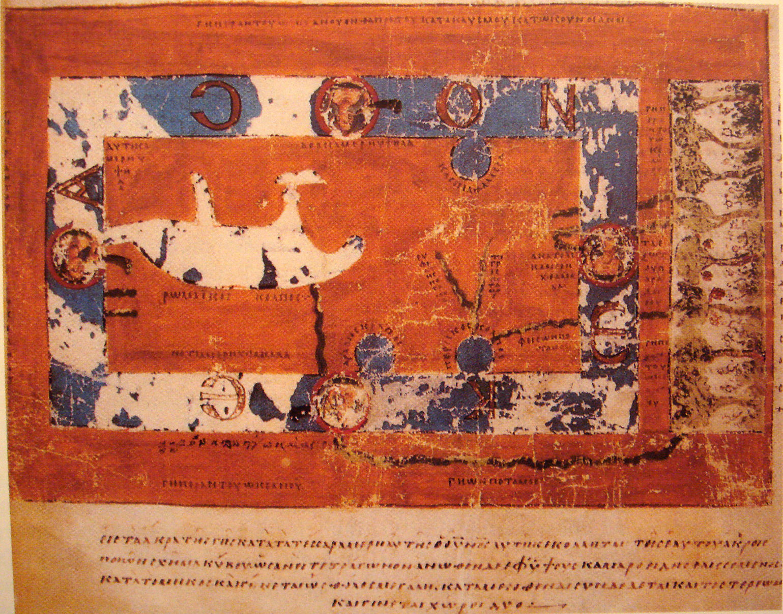
Cosmas Indicopleustes, the author of the Christian Topography, put forward the idea that the world is flat. Originally written in Greek with illustrations and maps, his view of the flatness of the world may have been influenced by some Jewish and Eastern contemporaries.[3] While most of the Christians of the same period maintained that the Earth was a sphere,[1] the work advances the idea that the world is flat, and that the heavens form the shape of a box with a curved lid, and especially attacks the idea that the heavens were spherical and in motion, now known as the geocentric model of the universe. The author cites passages from the Christians' scriptures which he interprets originally in order to support his thesis, and attempts to argue down the idea of a spherical Earth by stigmatizing it as "pagan". An early surviving reference to the work is by Patriarch Photios I of Constantinople in the 9th century AD. Photius condemns the style and syntax of the text as well as the honesty of the author. More recent authors tend to agree with Photius on the stylistic points, but to find the work generally reliable for geographical and historical references. Edward Gibbon, for example, said "the nonsense of the Monk was, nevertheless, mingled with the practical knowledge of the traveller" and used it in writing The History of the Decline and Fall of the Roman Empire.[4][5]

The world according to the book is a parallelogram.

The Topography is often erroneously cited as evidence that Christianity introduced the idea of the flat-Earth into the world, and brought in the age of ignorance. The latter pages of his work are devoted to rebutting the criticism of his fellow monks. He repeatedly denounces "those reprobate Christians who, ..., prefer, through their perverse folly or downright wickedness, to adopt the miserable Pagan belief that earth and heaven are spherical, and that there are Antipodes on whom the rain must fall up." Raymond Beazley, in the first volume of The Dawn of Modern Geography (1897), said[4][5]

The place of Cosmas in history has been sometimes misconceived. His work is not, as it has been called (in the earlier years of this century), the chief authority of the Middle Ages in geography. For, on the whole, its influence is only slightly, and occasionally, traceable. Its author stated his position as an article of Christian faith, but even in those times there was anything but a general agreement with his positive conclusions. . . The subtleties of Cosmas were left to the Greeks, for the most part; the western geographers who pursued his line of thought were usually content to stop short at the merely negative dogmas of the Latin Fathers; and no great support was given to the constructive tabernacle system of the Indian merchant. ... Yet, after all, the Christian Topography. must always be remarkable. It is one of the earliest important essays in scientific or strictly theoretic geography, within the Christian aera [sic], written by a Christian thinker.

Geography

[edit]

Besides the cosmological elements of the book, Christian Topography provides insight into the geographical knowledge of Byzantium, it is also the only Greek work with both text and illustrations surviving from the 6th century.[6] "Indicopleustes" means "The one who has sailed to India".[7] While it is known from classical literature that there had been trade between the Roman Empire and India, Cosmas was one of the individuals who had actually made the journey.[8] Indeed, we learn from his book that he had travelled over much of the Red Sea coast, and as far as modern Sri Lanka. He described and sketched some of what he saw in his Topography. Some of these have been copied into the existing manuscripts.

When not expounding his cosmology, Cosmas proves to be an interesting and reliable guide, providing a window into a world that has since disappeared. He happened to be in Ethiopia when the King of Axum was preparing a 522 or 525 AD military expedition to attack Jewish Arabs in Yemen. He recorded now-vanished inscriptions such as the Monumentum Adulitanum (which he mistakenly attributed to Ptolemy III Euergetes).

Manuscripts

[edit]

Three nearly complete manuscripts are known to exist. The earliest and best is from the 9th century, and is in the Vatican Library. This text has only ten books. Two closely related manuscripts of the 11th century, one from the Saint Catherine's Monastery and the other probably originally from the Iviron monastery of Mount Athos, contain twelve books and comment on the prophets in the same order that Theodore of Mopsuestia preferred rather than in Septuagint order as in the copy from the Vatican Library.[6] The eleventh and twelfth books may originally have been parts of other works by the same author. Portions of book five appear more frequently as a marginal commentary upon the psalms, and it is the name given to the author in these commentaries that is now used.[5]

Influence

[edit]

The influence of Cosmas was marginal, especially due to his background as a Nestorian who lived beyond the borders of the Byzantine Empire.[9]

David C. Lindberg asserts: "Cosmas was not particularly influential in Byzantium, but he is important for us because he has been commonly used to buttress the claim that all (or most) medieval people believed they lived on a flat earth. This claim...is totally false. Cosmas is, in fact, the only medieval European known to have defended a flat earth cosmology, whereas it is safe to assume that all educated Western Europeans (and almost one hundred percent of educated Byzantines), as well as sailors and travellers, believed in the earth's sphericity."[10] One of the contemporaries of Cosmas, John Philoponus, wrote a refutation of his work in his De opificio mundi (On the Creation of the World).[11]

References

[edit]
[edit]
Revisions and contributorsEdit on WikipediaRead on Wikipedia
from Grokipedia
Christian Topography is a 6th-century treatise on Christian cosmology and geography authored by , an Egyptian monk and former merchant who sailed to . Composed around 547 AD in , the work consists of twelve books that seek to harmonize biblical descriptions of the universe with empirical observations from the author's travels, rejecting pagan notions of a and heavens in favor of a flat, rectangular world enclosed under a vaulted . Originally planned as five books and later expanded, it draws on scriptural typology—particularly the structure of the Mosaic Tabernacle—to argue that the Earth forms a rectangular base beneath a domed sky, with the oceans contained within its boundaries and Paradise located at the world's edge. Cosmas, surnamed Indicopleustes ("India-voyager") for his trading expeditions, begins the text by identifying himself as a humble compelled by to refute erroneous cosmological views held even by some influenced by Greek philosophy. Books I through V primarily address theological and cosmological arguments, emphasizing the authority of Scripture over secular science and critiquing concepts like the and as incompatible with divine . Subsequent books (VI–XII) incorporate geographical details from Cosmas's journeys, including descriptions of , Indian ports, and the island of Ceylon (), where he notes maritime trade routes, local customs, and even ancient inscriptions linking to biblical history. The treatise survives in only a handful of Byzantine manuscripts, the earliest being an 8th–9th-century uncial in the and a 10th-century illuminated in Florence's , with a third partial copy in featuring vivid illustrations of Cosmas's rectangular world model. First edited in print by Bernard de Montfaucon in 1706 as part of his Collectio Nova Patrum et Scriptorum Graecorum, it was translated into English by John Watson McCrindle in 1897 for the Hakluyt Society, making its blend of , travelogue, and proto-cartography accessible to modern scholars. Though not a dominant influence on medieval —overshadowed by Ptolemaic traditions—the Christian Topography remains a key artifact of early Byzantine intellectual resistance to classical science, illustrating how 6th-century reconciled faith with the known world.

Background

Author

Cosmas , also known as Cosmas the Indian Navigator, was a Byzantine of Greek origin born in , , in the early sixth century. As a prosperous trader, he operated primarily from , engaging in commerce across the and beyond, which exposed him to diverse cultures and geographical knowledge. His early life reflected the vibrant mercantile environment of , a major hub for trade in spices, textiles, and luxury goods. Between approximately 522 and 525 CE, Cosmas undertook extensive voyages as a , along the , , and routes. These journeys took him to key trading ports such as in (modern ), where he witnessed preparations for the Aksumite expedition against the Himyarites; and the in ; and possibly as far as Ceylon (), though some scholars debate whether these latter visits were personal or based on reports from associates. During these travels, he documented observations of local , , and practices, often collaborating with fellow travelers like the monk Menas, which honed his practical understanding of regional geography. In his later years, following his active trading career, Cosmas renounced secular life and entered the monastery of Raithu on the , embracing within Nestorian Christian circles. As a self-taught autodidact, he had already developed deep scholarly interests in and , drawing from personal experiences and to challenge prevailing cosmological views with scriptural interpretations. Influenced by Antiochene and figures like , his monastic retreat allowed him to pursue these pursuits more rigorously, blending empirical knowledge from his voyages with theological inquiry.

Historical Context

In the 6th-century , the intellectual landscape was dominated by Neoplatonic and Aristotelian conceptions of a , inherited from through figures like , which posited a geocentric with and an orbicular terrestrial globe. These models, prevalent among educated elites in , faced increasing challenges from Christian , which interpreted passages such as Isaiah 40:22 and the Genesis creation account as describing a flat, enclosed world rather than a spherical one, prompting debates over the compatibility of pagan philosophy with scriptural authority. This tension reflected broader efforts to reconcile classical science with emerging Christian orthodoxy, particularly in scholarly centers where philosophers like defended spherical cosmology against literalist critics by integrating empirical observations with allegorical . Religious controversies further shaped this milieu, notably the aftermath of the in 451 CE, which affirmed the dyophysite —two natures in Christ, divine and human—against Miaphysite (monophysite) views that emphasized a single incarnate nature. Cosmas's work reflects his Nestorian sympathies, aligning with a tradition that emphasized scriptural literalism and critiqued influences from pagan philosophy as well as certain Christological positions. The reign of Emperor (527–565 CE) intensified these debates through imperial edicts enforcing Chalcedon, including the Second Council of Constantinople in 553 CE, fostering an environment where theological polemics intertwined with cosmological arguments to uphold perceived orthodox doctrine against heterodox influences. Monastic scholarship flourished in Sinai and during Justinian's era, serving as hubs for scriptural study and theological reflection that informed works like the Christian Topography. Justinian's construction of the fortified of Catherine at Sinai around 548–565 CE bolstered these centers, protecting pilgrims and scholars while promoting Chalcedonian orthodoxy against Miaphysite strongholds in Alexandria, where monastic communities debated cosmology as an extension of doctrinal purity. This scholarly network, blending ascetic discipline with intellectual inquiry, provided the backdrop for reconciling travel observations—such as those from merchant voyages—with biblical geography. Tensions between classical pagan geography and Christian worldviews were acute, as Ptolemy's Geography (2nd century CE), with its spherical Earth and zonal climates, clashed with literalist interpretations favoring a rectangular, ocean-encircled world derived from Exodus and Psalms. In Byzantine Alexandria, these conflicts manifested in rejections of "Hellenic" maps and models as idolatrous, prioritizing a scriptural cosmos that underscored divine order over empirical cartography. Such debates underscored the era's drive to Christianize knowledge, transforming pagan inheritance into tools for apologetics.

Composition

Purpose and Sources

Cosmas Indicopleustes composed the Christian Topography around 547 CE as a theological presented in the form of a travelogue, with the primary aim of reconciling biblical descriptions of the world with empirical while refuting the pagan doctrine of a , which he deemed heretical and incompatible with Christian scripture. Cosmas, having retired from his merchant life to become a in , sought to defend orthodox Christian cosmology against Hellenistic influences, arguing that the true shape and structure of the universe must align with divine revelation rather than philosophical speculation. This polemical intent is evident in his explicit rejection of rotating heavens and as "old wives' fables," positioning the work as a corrective to both pagan astronomers and certain Christian thinkers who had adopted spherical models. The foundational sources for the Christian Topography were biblical texts, particularly the translation of the , which Cosmas interpreted to support a flat, rectangular enclosed by mountains under a vaulted . He drew extensively on passages such as Isaiah 40:22, describing God as sitting "upon the circle of the earth," and evoking imagery of a stable, non-spherical world, alongside references from Job, Exodus, Genesis, and to construct his cosmological framework. These scriptural elements formed the core of his argument, with Cosmas insisting that should not doubt the world's form as revealed in holy writ, using them to counter scientific claims. In addition to scripture, Cosmas incorporated patristic writings from early , citing and critiquing figures like for adopting ideas, and on geographical features such as seas as enclosed gulfs, though he critiqued Basil's apparent acceptance of spherical notions. Other influences included , , and Severian of Gabala, selected to bolster his theological positions. To provide empirical validation, Cosmas integrated firsthand observations from his travels as a prior to his retirement, including voyages along the , to (notably and Ceylon), and to (Abyssinia), which he used to corroborate biblical with real-world details.

Overall Structure

The Christian Topography is structured as a comprehensive divided into 12 books, originally planned as five books and later expanded, reflecting a deliberate progression in argumentation. Books 1–5 address general theological foundations, primarily refuting pagan doctrines of a and establishing scriptural authority for Cosmas's views through and . Books 6–10 delve into cosmology and , detailing the , celestial phenomena, and earthly layout with supporting diagrams. Books 11–12 shift to topics, incorporating Cosmas's observations to affirm the antiquity of biblical narratives and the reach of Christian . The organizational framework employs two introductory prologues—one urging careful reading and the other dedicating the work to a patron while outlining the initial five books—followed by digressions on historical, geographical, and scriptural matters that interrupt the main flow to reinforce key points. Appended diagrams, such as schematic representations of the cosmos and biblical structures, accompany these sections to visually substantiate the textual claims, creating a layered argument that moves from abstract theology to concrete spatial description. This format serves Cosmas's polemical aims by methodically linking scripture to observable geography, countering contemporary scientific ideas with faith-based reasoning. Illustrations are integral to the work's presentation, with 177 surviving miniatures depicting 96 discrete scenes across manuscripts functioning as visual aids that clarify complex concepts; these include world maps depicting the rectangular earth enclosed by mountains, diagrams of the symbolizing the universe's form, and sketches of regional features like oceans and islands. The original Greek text spans approximately 100,000 words, characterized by a blend of elements drawn from Cosmas's merchant voyages, sharp polemical critiques of Aristotelian and Ptolemaic models, and vivid descriptive passages on natural and human landscapes.

Cosmology

Universe Model

Cosmas Indicopleustes envisioned the as a flat, rectangular plane, approximately twice as long from east to west as it is broad from north to south, positioned beneath a solid, vaulted that forms a protective canopy over the world. This , likened to the veil of the biblical , encloses the habitable realm like a rectangular chamber, dividing the into distinct upper and lower domains. The lower world consists of the flat surface interspersed with lands and oceans, all encircled by an impassable ocean that bounds the known world, beyond which lies an elevated continental expanse culminating in Paradise at the eastern extremity. The takes the form of a two-storied rectangular structure, with the as the base of the lower story and the serving as both its ceiling and the floor of the heavenly realm above. This arched configuration supports the lower world of mortal existence while elevating the divine sphere, creating a compartmentalized where human habitation is confined to the flat expanse below. Cosmas develops this model across the work, integrating observational geography with theological architecture in Books 6 through 9 to affirm a bounded, non-infinite . Rejecting the Hellenistic notion of a , Cosmas argued that such a would imply the absurd existence of —people living upside down on the opposite side—where rain would fall toward the s rather than the ground, defying natural order and scriptural truth. He further dismissed lunar eclipses as evidence for , portraying pagan explanations involving orbital shadows as fictitious inventions incompatible with a fixed, vaulted . These critiques targeted astronomers like , whose circular models Cosmas deemed impious for contradicting the flat, enclosed world described in sacred texts. In Cosmas's framework, the heavenly bodies—sun, , and —operate within the space under the , propelled by angels rather than adhering to spherical orbits around a central . The sun, depicted as roughly the size of two climatic zones (about 635 miles in diameter), circles a massive northern conical that partially obscures it, producing day and night cycles based on its position relative to the Earth's edges and seasonal variations in its path width. Similarly, the moon and follow comparable trajectories beneath the dome, ensuring their motions align with the flat plane's and divine oversight, without venturing into an infinite void.

Biblical Foundations

Cosmas Indicopleustes drew heavily on the description of the in Exodus 25–40 to establish a biblical blueprint for the universe's shape and divisions, interpreting it as a divinely ordained microcosm of the cosmos. He argued that God instructed Moses to construct the "according to the pattern shown thee in the mount" (Exodus 25:40), which Cosmas understood as a direct representation of the 's structure, with its rectangular form and internal partitions mirroring the earth's flat expanse and the firmament's separation of heavenly and earthly realms. The outer sanctuary, containing the , table, and shewbread, symbolized the visible with its , land, and produce, while the inner in the west represented the eternal heavenly abode, accessible only through the eastward entrance that signified humanity's origin and eschatological return. This typological framework, echoed in Hebrews 9:1–2 and 9:11, positioned the as the "pattern of this ," not made with hands but prefiguring Christ's redemptive work. In interpreting Genesis 1, Cosmas viewed the created on the second day as a solid, dome-like structure separating the waters above from those below, forming an impenetrable barrier that upheld his conception of a bounded, non-spherical . He cited Genesis 1:6–8 directly, emphasizing that "called the ," which he described as a visible, intermediate affixed to the highest and resting upon the earth's edges, thus rejecting any notion of infinite or . Complementing this, 104:5 provided scriptural support for the earth's flatness and stability, with Cosmas quoting, "Who hath laid the foundations of the upon its own stability, that it should not be moved for evermore," to argue that the rests on divine foundations without physical props or , inherently flat and oblong in form. These exegeses underscored a tiered cosmology where the earth's inhabited portion occupies the lower level, fixed and immovable. Cosmas employed polemics against classical by reinterpreting Isaiah 40:22 and Job 38 to affirm a flat, rectangular enclosed by a vaulted , dismissing pagan models as incompatible with divine . In Isaiah 40:22, he focused on the phrase "He that stretcheth out the heavens as a curtain, and spreadeth them out as a to dwell in," portraying the as a flat plane under a tent-like canopy rather than a , thereby invalidating concepts of and . Similarly, Job 38:4–6, with its rhetorical questions—"Where wast thou when I laid the foundations of the ? declare, if thou hast understanding. Who hath laid the measures thereof, if thou knowest? or who hath stretched the line upon it? Whereupon are the foundations thereof fastened? or who laid the corner stone thereof?"—served to emphasize the 's fixed, rectangular foundations and bounded limits, directly countering Hellenistic notions of orbital motions and eclipses as mere illusions. Through these passages, Cosmas prioritized scriptural literalism over empirical astronomy, asserting that true knowledge derives solely from and the prophets. Central to Cosmas' exegesis were typological connections linking , the , and the world structure, viewing them as successive divine archetypes of cosmic order and . He paralleled the Ark's three-tiered design in Genesis 6:16—lower for beasts, middle for humans and animals, upper for birds—with the Tabernacle's divisions, both symbolizing the world's hierarchical realms from the subterranean waters to the heavenly vault, preserved through and revelation alike. This typology extended to the itself, where the Ark prefigured the Tabernacle's role as a type of the present world, ultimately pointing to the eternal "true Tabernacle" in heaven ( 9:11), encompassing humanity's journey from creation to consummation. Such links reinforced Cosmas' overarching model of a rectangular, enclosed , derived entirely from these biblical precedents.

Geography

World Layout

In ' geographical schema, the inhabited world, or oikoumene, is depicted as a flat rectangular , extending twice as long from east to west as it is broad from north to south, modeled after the rectangular table of the described in Exodus. This oblong form rejects the of classical geographers, emphasizing instead a bounded, planar surface under a vaulted fastened at its . The overall layout positions the known lands within this rectangle, with the forming a central gulf dividing the northern regions. The oikoumene is bounded on all sides by the encircling , a vast, unnavigable that surrounds the inhabited lands and separates them from an outer earth beyond. This renders the world's edges impassable for humans, except in conceptual access located in the eastern extremity beyond it, where the four biblical rivers originate and flow underground into the oikoumene. Within this framework, and constitute the primary bulk of the rectangle, with occupying the eastern portion near the sunrise and the western near the sunset, while extends as a southern attached to the main . Cardinal directions in this layout are oriented biblically, with east as the sacred starting point of creation and , running lengthwise along the rectangle's primary axis, while north-south defines the shorter breadth. Climatic variations arise from this orientation and the flat plane's interaction with celestial movements, resulting in habitable central zones flanked by uninhabitable extremes of heat in the and in the north, without the classical division into multiple latitudinal bands or antipodal regions.

Regional Descriptions

Cosmas Indicopleustes offers vivid ethnographic and geographical accounts of distant lands in Book 11 of his Christian Topography, drawing from his mercantile voyages to integrate personal eyewitness reports with hearsay from traders and locals. His descriptions emphasize trade networks, local customs, natural resources, and the presence of Christian enclaves, portraying a interconnected oikoumene shaped by and faith. In his treatment of India, Cosmas highlights key ports such as Kalliana (near modern ), a bustling center for exporting and cloth, and (possibly Malabar), renowned for its pepper trade where tame taurelaphi (antelopes or ) transport the spice from groves. He details the flora, including the pepper vine that entwines wild trees and the argellia ( palm), whose nut yields sweet water known as rhongcosura, vital for sailors. Fauna receives attention too, with mentions of the (called harisi by , hunted for its hide used in shields), the wild ox providing toupha plumes for royal adornment, and the elusive moschus deer yielding for perfume. Ethnographically, he notes the region's diverse peoples, including the warlike White Huns in the north who command 2,000 elephants, and scattered Christian communities amid Hindu and Buddhist customs. Further north, at Sindu, trade in and castor thrives, underscoring India's role as an eastern emporium. Turning to Sri Lanka, which Cosmas calls Taprobane or Sielediba, he depicts it as an island roughly 900 miles in length and breadth according to local reports, encircled by smaller isles abundant in freshwater springs and coconut groves that serve as provisioning stops for ships. As a pivotal trade nexus, it imports , aloeswood, and cloves from Persia, , and the distant Tzinitza (), while exporting precious gems like hyacinth () from its interior mines, from coastal areas, and . The island's society features two heathen kings in rivalry—one ruling the gem-rich highlands, the other the commercial harbor—yet it hosts a notable Persian Christian settlement complete with a church, , and , reflecting missionary outreach. Cosmas praises the and fertile soils supporting rice and diverse fruits, contrasting with the tropical excesses of mainland . Cosmas's accounts of Ethiopian and Nubian regions center on the coast and Aksumite heartland, where he visited the port of around 525 CE, describing its monumental Ptolemaic inscribed with Greek records of from inland tribes. Here, trade flourishes in ivory from elephants (with tusks exported to and Persia), hides for agricultural tools, and giraffes tamed for royal parades, alongside teeth weighing up to 13 pounds used in jewelry. The , a Nubian people from the Nile's upper reaches, supply emeralds bartered for Indian spices and textiles, their nomadic customs involving raids and in Sasu rivers where nuggets called tancharas are gathered by hand. Cosmas traces the Nile's sources to , fed by monsoon rains, and notes the Christian dominance in Aksum, with bishoprics and monasteries amid pagan holdouts; local flora includes trees tapped seasonally, and like crocodiles in riverine marshes. These areas form the southern frontier of his rectangular , linking African interiors to oceanic routes. For European and Asian interiors, Cosmas sketches broader outlines in , positioning in the frigid northern expanses beyond the , where nomadic tribes endure harsh winters, herding hardy livestock and trading furs southward in exchange for grains and metals. He portrays them as descendants of , with customs of mounted warfare and shamanistic rites, their lands sparsely vegetated with conifers and grazed by wild asses. occupy the eastern Asian plateaus, famed for breeding swift horses exported to and for caravans originating from Tzinitza, passing through their markets en route to Roman ports; Zoroastrian temples coexist with growing Christian pockets under Sassanid tolerance. Roman provinces, stretching from Gadeira (Cadiz) in the west to , represent the civilized core, unified by imperial coinage (solidi) facilitating trade in wine, , and ceramics; Cosmas observes diverse customs, from Celtic tattooing in to Syrian weaving, with robust Christian communities anchored by cathedrals and episcopal oversight. Throughout these interiors, he highlights flora like Persian and steppe grasses, fauna including lions in Asian hills and bears in European forests, and the diffusion of via merchant networks he personally navigated.

Manuscripts

Surviving Copies

The Christian Topography of Cosmas Indicopleustes survives without an autograph manuscript, having been transmitted through Byzantine monastic scriptoria, primarily in Constantinople and other centers like Cappadocia. The earliest complete manuscript is Vaticanus Graecus 699, an uncial codex from the 9th century produced in Constantinople and now held in the Vatican Library; it contains books 1–10 and includes illustrations that visually support the text's cosmological arguments. Key later copies include the 11th-century Sinai Gr. 1186, a minuscule manuscript likely from preserved at St. Catherine's Monastery on , and Laurentianus plut. 9.28, also from the 11th century, housed in the in ; both are complete with 12 books. In total, about 20 Greek manuscripts survive, consisting of these three complete illustrated codices alongside numerous partial copies and fragments, often excerpted in catenae on the or Gospels. A partial copy consisting of only a few leaves is preserved in the in , featuring illustrations of Cosmas's rectangular world model. Fragments also exist in Armenian and Syriac, attesting to the work's circulation beyond Greek-speaking contexts.

Illustrations

The manuscripts of the Christian Topography contain 177 miniatures depicting 96 distinct scenes, including diagrammatic illustrations that complement Cosmas Indicopleustes' textual descriptions, appearing integrated within the structure of Books II through V and IX to XI. These diagrams employ a distinctive Byzantine schematic style, featuring linear outlines, geometric forms, and minimal shading to convey complex ideas with clarity and economy. Influenced by late antique , such as zonal maps from Ptolemaic traditions adapted to Christian ends, the illustrations prioritize didactic precision over naturalistic rendering, often using labeled elements to guide the viewer's interpretation. Prominent among these is the rectangular , portraying the as a flat rectangle encircled by , with Paradise positioned in the east and key regions like Ethiopia and India marked to align with Cosmas' accounts and biblical . Another key example comprises cross-sections of the , depicting its rectangular base, veils, and cherubim in layered views that reveal internal compartments as analogous to cosmic layers. These visuals not only elucidate spatial relationships but also underscore symbolic functions rooted in biblical typology, where elements like the or Ark serve as microcosms of the , mirroring divine order from creation narratives in Exodus and Genesis. By presenting the world in rectilinear form, the illustrations actively refute models derived from pagan philosophers like , affirming instead a scriptural under a vaulted . Across surviving manuscripts, such as the ninth-century Vatican Greek 699 and the eleventh-century Florence Laurentian Plut. 9.28, the illustrations exhibit variations that reflect scribal adaptations while preserving the original program's integrity. Earlier copies, like the Vatican exemplar, render diagrams in ink for stark emphasis, whereas later versions introduce colors—such as for sacred boundaries, blue for heavenly vaults, and green for earthly paradises—to heighten symbolic resonance and aesthetic appeal without altering compositional schemas. These enhancements likely arose in monastic scriptoria, where illuminators balanced fidelity to Cosmas' vision with contemporary Byzantine artistic conventions.

Legacy

Medieval Influence

The Christian Topography of circulated primarily within Byzantine monastic communities, where it was copied and preserved in illustrated manuscripts dating from the 9th to the 11th centuries, including a notable exemplar from the Monastery of St. Catherine on . This dissemination is evidenced by the survival of three principal codices, which reflect ongoing interest in Cosmas's scriptural cosmology among Eastern Orthodox scribes and theologians. By the , the work had reached prominent intellectual circles, as demonstrated by its inclusion in Patriarch Photius's Bibliotheca (Codex 36), where he offered a pointed of its verbose style, absurd geographical claims, and rejection of classical spherical-earth models in favor of a flat, rectangular world. Photius acknowledged some value in its historical and travel-related details but dismissed its core arguments as fabulist and obstinately anti-scientific, highlighting the text's controversial reception even within Byzantine scholarship. In Eastern Christian traditions beyond Byzantium, the Christian Topography found adoption among Syriac and Armenian communities, likely facilitated by Cosmas's own Nestorian-leaning affiliations and the work's alignment with Antiochene . Evidence of early engagement includes a Syriac marginal note quoting the text in a 10th-century (, New College Library, MS 333), suggesting transmission through Syriac scribal practices as early as the via Nestorian networks in the . Armenian reception is attested indirectly through shared cosmological motifs in medieval Armenian geographical texts, which echo Cosmas's tabernacle-inspired world model, though full translations remain unrecovered. Access to the Christian Topography in the West was limited, primarily through fragmentary excerpts and indirect transmission rather than complete translations, with knowledge confined to isolated monastic or scholarly debates until the . These fragments contributed to early cartographic discussions, as seen in the 8th-century Albi Map, which perpetuates ancient geographical traditions blending Ptolemaic elements with Cosmas-like flat-earth schematics, influencing the of insular mappaemundi. By the , such echoes persisted in Western debates over biblical versus empirical , though the work's full impact remained marginal compared to dominant spherical models.

Modern Interpretations

The first complete printed edition of the Christian Topography appeared in 1706, edited by Bernard de Montfaucon in his Nova Collectio Patrum et Scriptorum Graecorum, drawing on the primary Florentine and Vatican manuscripts with a Latin translation and notes. This paved the way for J. W. McCrindle's influential English translation in 1897, published by the Hakluyt Society, which emphasized the text's geographical insights while contextualizing its cosmological framework. E. O. Winstedt followed with a critical Greek edition in 1909, incorporating geographical annotations to highlight Cosmas's empirical observations from his travels. Twentieth-century scholarship advanced textual analysis through Wanda Wolska-Conus's multi-volume critical edition in the Sources Chrétiennes series (1968–1973), offering a revised Greek text, French translation, and detailed commentary on theological and scientific elements. Paul Canart, as a at the , facilitated facsimile reproductions and studies of key illustrated manuscripts, such as Vat. gr. 699, aiding paleographical and iconographic research. Paul Magdalino's examinations of Byzantine have integrated Cosmas's work into broader discussions of and in the empire's scientific traditions. Interpretations in modern scholarship contrast the Christian Topography as a polemical rejection of pagan cosmology in favor of scriptural literalism with readings that see it as an allegorical synthesis of biblical typology and practical knowledge from routes. Critics have dismantled 19th-century myths depicting Cosmas's rectangular model as typical of medieval anti-science, arguing it was an eccentric Nestorian-influenced view marginal to mainstream patristic thought. Today, the text benefits from digital cataloging in resources like the Pinakes database, which documents over two dozen Greek manuscripts and supports interdisciplinary patristic research on late antique exegesis. Ongoing studies explore its implications for theology-science dialogues, with recent analyses focusing on illuminations and their sources in 6th-century Alexandria.

References

Add your contribution
Related Hubs
User Avatar
No comments yet.