

Community hub
Recent from talks
Contribute something
Nothing was collected or created yet.
Kolaba Fort
View on Wikipedia
Kolaba Fort located at Alibag beach is an old fortified maritime base in Alibag. It is situated in the sea at a distance of 1–2 km from the shores of Alibag, 35 km south of Mumbai, in the Konkan region of Maharashtra, India. It is a popular tourist destination and a protected monument.[1]
Key Information


History
[edit]The first mention of Kulaba fort is when it was chosen by Chhatrapati Shivaji Maharaj to be fortified after the whole of South Konkan became free.[citation needed] The work of constructing the fort started in 19 March 1680. In 1662, he strengthened and fortified Kolaba fort to make it one of his chief naval stations.[2] The command of the fort was given to Darya Sarang and Mainak Bhandari under whom Kolaba Fort became the centre of the Maratha attacks on British ships.[3] Kolaba Fort was captured by Chatrapati Shivaji.[citation needed]
The fort was completed in June 1681 by Chatrapati Sambhaji Raje after the death (in 1680) of Shivaji.[4] In 1713, under a treaty with Peshwa Balaji Vishwanath, Kolaba along with several other forts was given over to Sarkhel Kanhoji Angre.[5] He used it as his main base from which to launch raids on British ships. In 17 November 1721, the British, incensed at Angre's activities, joined the Portuguese in an expedition against Kolaba. A Portuguese land force of 6000 and three English ships of the line under Commodore Mathews co-operated but the attempt failed. The British blamed the failure on the "cowardice of the Portuguese". About this time Kolaba is described by Hamilton as a fort built on a rock, a little way from the mainland and at high water an island.[3] On 4 July 1729, Kanhoji Raje Angre died on the Kolaba Fort. In 1729, many buildings were destroyed due to a major fire incident near the Pinjara Bastion. In 1787, another major fire incident took place in which the Angre Wada was destroyed. In 1842, the British sold the wooden structures in the fort by auction and used the stones for the construction of Alibag water works.[citation needed]
Etymology
[edit]The exact origin of the name Kolaba is unclear, but has been suggested to be derived from kolvan or kolbhat, meaning a Koli hamlet, and also from kalabeh, which means a neck of land jutting out into the sea.[6]
Major features
[edit]The average height of the fort walls is 25 feet. It has two main entrances, one on the seaside and the other towards Alibag. An interesting feature of this fort is that it has freshwater wells in its premises even though it is a seaside fort. In the monsoons, the fort can be reached by wading through waist-deep water at low tide. However, at high tide, boats must be used to reach it. In the fort are temples and houses in which several caretakers stay. The fort should be visited during the low sea tide season. There is a Dargah of Haji Kamaluddin Shah on the fort. Near the northern wall lie two English cannons mounted on wheels with the inscription "Dawson Hardy Field, Low Moor Ironworks, Yorkshire, England". The Siddhivinayak temple inside the fort was built by Raghoji Angre in 1759.[3]
-
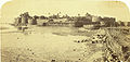 Colaba or Kolaba Fort, 1855.
 -
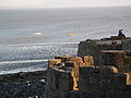
 Kolaba Fort walls hugging the sea
 -
 Water tank at the centre of Kolaba Fort
 -
 Siddhivinayak temple in Kolaba Fort
 -
 Looking out to sea
 -
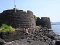 Kolaba Fort entrance


See also
[edit]References
[edit]- ^ "List of the protected monuments of Mumbai Circle district-wise" (PDF). Archived from the original on 6 June 2013.
- ^ Sen, Sailendra (2013). A Textbook of Medieval Indian History. Primus Books. p. 207. ISBN 978-9-38060-734-4.
- ^ a b c Gazetteer of the Bombay Presidency. Govt Central Press. 1883. pp. 261–265. Retrieved 19 March 2009.
- ^ Colaba Trek Raigad District
- ^ "Serial Nomination of Maratha Military Architecture in Maharashtra". UNESCO World Heritage Centre. Retrieved 26 June 2021.
- ^ Hakluyt Society (1967). Works by Hakluyt Society. Kraus Reprint. p. 7.
Kolaba Fort
View on GrokipediaLocation and Geography
Site Description
Kolaba Fort occupies a rocky island in the Arabian Sea, positioned 1 to 2 kilometers offshore from Alibag beach in Raigad District, Maharashtra, India, at geographical coordinates 18°38'02.40"N 72°51'51.12"E.[3][4] The site spans an island approximately 267 to 927 meters long from north to south and 109 meters wide from east to west, situated amid coastal waters that render it strategically isolated yet accessible.[5] The fort's layout features robust defensive walls averaging 25 feet in height, enclosing an area with two primary gateways—one oriented toward the open sea and the other facing Alibag—to facilitate naval and landward approaches.[4][6] Internal elements include freshwater wells, essential for sustaining occupants during sieges, underscoring the site's adaptation to its maritime environment.[6] Accessibility varies with tidal cycles: during low tide, a 1- to 2-kilometer expanse of sea bed exposes a natural pathway for foot or cart travel from the shore, while high tide submerges this route, necessitating boat transit and emphasizing the fort's tidal dependency.[7][5] The surrounding geography, characterized by sandy beaches and shallow coastal waters, integrates the fort into Alibag's broader estuarine landscape, where seasonal monsoons influence water levels and site conditions.[8]Accessibility and Environmental Context
Kolaba Fort is located approximately 1–2 kilometers offshore from the shores of Alibag in Maharashtra's Konkan region, positioned on a tidal island in the Arabian Sea.[9] The island measures 267 to 927 meters in length from north to south and 109 meters in width from east to west.[5] Access to the fort depends on tidal conditions; during low tide, the sea bed exposes a path allowing pedestrians to walk from Alibag Beach to the site.[7] At high tide, when the fort becomes fully isolated as an island, visitors must use boats or ferries departing from Alibag Beach, with schedules aligned to tide timings for safety.[10] The fort's elevation stands at about 7–8 meters above sea level, facilitating defense while embedding it within the dynamic coastal seascape.[11] The environmental context features the Arabian Sea's tidal fluctuations, which create a unique interplay of land and water, surrounded by azure coastal waters and proximate sandy beaches like Alibag Beach roughly 2 kilometers away.[9] This maritime setting, with its robust sea integration, underscores the fort's historical role as a strategic naval outpost amid the Konkan's temperate, monsoon-influenced climate.[12]History
Origins and Construction
Kolaba Fort originated as a strategic initiative by Chhatrapati Shivaji Maharaj to fortify the Maratha naval presence along the Konkan coast following the consolidation of control over southern Konkan in the 1670s. This region, vulnerable to incursions from the Siddis of Janjira, Portuguese naval forces, and Mughal allies, necessitated a robust sea fortification to safeguard maritime trade routes and support the expanding Maratha fleet. The site's selection off the Alibag shore provided natural defensive advantages, with tidal access enabling reinforcement while isolating it from land-based assaults during high tide.[13][14] Construction commenced on March 19, 1680, under Shivaji's direct oversight, marking it as one of his final military projects before his death on April 3, 1680. The fort was designed as a self-contained bastion, incorporating high walls, bastions for artillery, and freshwater tanks to sustain a garrison during sieges. This effort aligned with Shivaji's broader vision of naval supremacy, complementing earlier fortifications like Khanderi and Underi to challenge European dominance in the Arabian Sea.[15][7] Following Shivaji's passing, his son Chhatrapati Sambhaji Maharaj oversaw the completion of the structure in June 1681, ensuring its operational readiness as a key Maratha naval station. The completed fort spanned approximately 900 feet in length and 350 feet in width, with walls rising 25 feet high, engineered to withstand cannon fire and tidal fluctuations. Historical accounts from the period, including contemporary Mughal records, later recognized Kolaba as among Shivaji's strongest seaside defenses.[8][16]Role in Maratha Empire
Kolaba Fort emerged as a pivotal naval stronghold for the Maratha Empire after Chhatrapati Shivaji Maharaj fortified it in the late 17th century, following the conquest of southern Konkan, to secure the coastline against external threats and support maritime expansion. This development aligned with Shivaji's strategy to establish a blue-water navy capable of challenging Portuguese and other European influences in the Arabian Sea, positioning the fort as a forward base for patrols and defensive operations along key trade routes.[17][6] Under commanders Darya Sarang and Mainak Bhandari, the fort served as a launchpad for targeted assaults on British merchant ships, disrupting colonial commerce and asserting Maratha dominance in regional waters during the early phases of empire-building. These operations highlighted Kolaba's role in enforcing tolls on passing vessels and countering incursions, thereby sustaining economic leverage through control of Konkan fisheries and shipping lanes.[18][10] By 1713, a treaty between Peshwa Balaji Vishwanath and Sarkhel Kanhoji Angre ceded the fort to Angre, who elevated it to his principal headquarters for the Maratha fleet, utilizing its proximity to Alibag for ship repairs and as a staging point for extended campaigns against European naval forces. This tenure reinforced the fort's function in maintaining imperial sovereignty over coastal territories amid internal Maratha factionalism and external pressures, until Angre's successors faced mounting challenges in the mid-18th century.[19][20]Key Battles and Conflicts
Kolaba Fort functioned as a critical naval outpost for the Marathas, enabling commanders like Darya Sarang and Maynak Bhandari to orchestrate attacks on British East India Company ships during the early 18th century, thereby disrupting colonial trade routes along the Konkan coast.[2] Under Kanhoji Angre, who assumed control around 1698 and fortified the structure extensively, the fort supported broader Maratha efforts to challenge Portuguese and Siddi naval dominance, including seizures of enemy vessels and enforcement of tribute from European traders.[2] [21] A notable external assault occurred in 1722, when British and Portuguese forces launched a coordinated attack on the fort to curb Maratha piracy; the expedition collapsed due to the Portuguese contingent's failure to press the engagement, allowing Maratha defenders to repel the invaders without significant territorial loss.[2] This event underscored Kolaba's defensive resilience, bolstered by its tidal island position, which limited amphibious approaches to specific low-tide windows. Internal strife intensified after Kanhoji Angre's death in 1729, transforming the fort into a prize among his feuding sons. In 1734, Manaji Angre seized Kolaba amid quarrels with his brothers Sambhaji and Yesaji, consolidating his hold with Peshwa support before imprisoning Yesaji nearby at Alibag.[21] By April 1740, Sambhaji, allied with Tulaji Angre, invaded Manaji's domain, capturing Alibag, Thai, and Sagar-gad before besieging Kolaba itself; Manaji's appeals prompted Peshwa Balaji Bajirav to intervene decisively, defeating Sambhaji's forces and killing 25 to 30 assailants, thus raising the siege and preserving Manaji's control.[21] These fraternal conflicts weakened the Angre clan's cohesion but highlighted Kolaba's enduring military value in Maratha power dynamics. The fort's role extended to auxiliary support in regional campaigns, such as Manaji's blockade of Portuguese sea lanes during their 1739 siege of Bassein, which aided Maratha land forces under the Peshwa and contributed to the destruction of the Portuguese fleet in 1740.[21] By the mid-18th century, repeated engagements had eroded its fortifications, though it remained a symbol of Maratha maritime defiance until ceded to British oversight in 1840 following the Angre lineage's decline.[2]Decline and Later Ownership
Following the cession of Kolaba Fort to Kanhoji Angre in 1713 via treaty with Peshwa Balaji Vishwanath, the stronghold served as the primary seat of the Angre clan's naval operations, with authority passing to his successors amid growing internal divisions and external pressures that eroded Maratha maritime supremacy by the late 18th century.[22] Succession disputes after Kanhoji's death in 1729 fragmented the family's territories and resources, as Peshwa interventions divided holdings among his sons—Manaji assuming control from Kolaba—fostering rivalries that diminished unified naval strength against European powers.[23] The fort's decline accelerated under later Angre rulers in the early 19th century, particularly during Raghuji Angre's tenure from 1817 to 1838, marked by oppressive governance that alienated subjects and weakened administrative control.[22] Raghuji died on 26 December 1838, leaving a posthumous son, Kanhoji II, who was recognized as chief on 6 February 1839 but succumbed on 21 March 1839, effectively terminating the legitimate Angre lineage without viable heirs.[22] With no succession, the fort was handed over to British authorities in 1839, followed by formal annexation of Kolaba territory in 1840, as British policy rejected adoption claims by Raghuji's widows to prevent revival of independent rule.[22] By 1846, surviving Angre residential structures within the fort were auctioned, signifying the complete transfer of ownership and the site's reduced military role.[22]British Colonial Period and Independence Era
Following the death of Kanhoji II Angre without heirs in 1840, Kolaba Fort and the associated Colaba State lapsed to British control, marking the end of Angre family rule over the territory.[2] Earlier, in 1817, British forces had established order in the region after conflicts with the Angres, though full annexation occurred in 1840.[2] Under British administration, the fort's role shifted from active Maratha naval operations against European shipping to relative dormancy, as colonial naval dominance reduced the need for such coastal defenses.[24] During the British colonial era, Kolaba remained part of the Bombay Presidency, with the surrounding Kolaba district experiencing limited development due to poor infrastructure and communications.[22] The fort itself saw no documented major military engagements or reconstructions, serving instead as a historical outpost amid the consolidation of British maritime supremacy in the Arabian Sea. British officials managed the transition by providing pensions to select local elites displaced by the annexation, addressing administrative challenges in the former Angre territories.[25] With India's independence on August 15, 1947, Kolaba Fort transitioned to the sovereignty of the newly formed Republic of India, integrated into the state of Maharashtra following linguistic reorganization in 1960. Post-independence, the fort was preserved as a cultural heritage site, emphasizing its Maratha legacy rather than active defense. Today, it functions primarily as a tourist destination accessible via a rocky path during low tide, featuring preserved elements like temple ruins and bastions, under state protection to prevent further erosion from tidal exposure.[26][27]Architecture and Features
Defensive Fortifications
Kolaba Fort's primary defensive advantage stems from its position on a low rocky island approximately 200 meters from the Alibag shore, surrounded by the Arabian Sea and accessible only via a causeway at low tide, which served as a natural moat.[2] The fort's enclosure consists of a perimeter wall forming a circuit of about 700 paces, with heights ranging from 20 to 25 feet, providing a formidable barrier against seaborne assaults.[2] The walls were constructed using large black trap stone blocks, typically measuring 3 by 2 feet, laid without mortar to ensure durability against erosion and bombardment, though later repairs incorporated mortar.[2] Strengthening these defenses were 17 towers positioned at central and corner points along the curtain walls, which varied from 4 to 6 feet in thickness; only three of these towers remain intact today.[2] Parapets rising 6 feet high atop the walls supported infantry defense, complemented by sentry boxes and guard rooms for vigilance.[2] Entry to the fort was controlled through two principal gates: the Maha Darvaja in the northeast, featuring a pointed arch flanked by towers and originally secured by a teak door studded with iron spikes, and a smaller southern gate.[2] An additional north outwork known as Sarjakot, built with massive trap blocks to a height of about 25 feet, provided artillery protection for the main structure.[2] Further seaward defenses included a ship dock measuring 80 by 38 paces south of the walls, facilitating naval operations while maintaining defensive positioning.[2] Artillery formed a critical component of the fortifications, with two old cannons positioned on the northwest parapet for signaling and defense, alongside remnants of Maratha-era guns embedded in wall embrasures facing the sea.[2] [7] Near the northern wall, two English cannons mounted on wheels, dating to the colonial period, underscore the fort's later military adaptations, though the core defenses were designed for Maratha naval warfare under Shivaji's reconstruction in 1662.[7][2]Internal Structures and Monuments
The Siddhivinayak Temple stands as the principal monument inside Kolaba Fort, dedicated to Lord Ganesha and constructed in 1759 by Raghoji Angre, a prominent Maratha admiral.[26] [28] The temple features an inner sanctum with images of Sri Ashtabhuja Devi alongside the central deity idol, reflecting syncretic devotional elements typical of Maratha-era fortifications.[28] A large central freshwater tank, positioned north within the fort's enclosure, served as a vital water reservoir for the garrison, enabling prolonged defense against naval blockades despite the surrounding seawater.[29] [30] Complementing this are two additional freshwater wells, underscoring the fort's self-sufficiency in hydration amid its isolated maritime setting.[6] Several smaller temples dedicated to various deities occupy the interior, alongside the Dargah of Haji Kamaluddin Shah, indicating religious pluralism within the Maratha stronghold.[31] Rusted cannons from the Maratha period lie scattered among the ruins of barracks and other utilitarian buildings, remnants of the fort's operational military infrastructure.[31] The internal masonry construction employs traditional techniques without lime mortar, contributing to the durability of structures like the temple and tank walls against coastal erosion and conflict.[30] Animal carvings, including peacocks, elephants, deer, lotuses, and mythical sharabhs, adorn entry points and walls, blending defensive utility with symbolic artistry.[5]Etymology and Naming
Linguistic Origins
The name Kolaba, also rendered as Kulaba in historical Marathi texts, derives from the Marathi term kulābā (कुलाबा), denoting a narrow neck of land or promontory extending into the sea, aptly describing the fort's position on a rocky outcrop protruding into the Arabian Sea off Alibag's coast.[32] This etymology aligns with the fort's strategic maritime placement, 1–2 km from the shoreline, emphasizing its role as a defensive extension into the water rather than an inland structure.[29] Alternative derivations link Kolaba to pre-Maratha indigenous influences, particularly the Koli fishing communities of the Konkan region, where Kolabhat or Kolbhat referred to Koli settlements near water bodies, potentially influencing the name through phonetic adaptation in local dialects.[33] Some accounts propose a composite from Marathi kul (tribe or clan, possibly alluding to Koli roots) and āb or āp (water), signifying a place enclosed or defined by water on multiple sides, though this lacks direct attestation in primary Marathi lexicons and appears as a folk etymology.[34] These origins reflect the interplay of geography, indigenous nomenclature, and Maratha adaptation, without evidence of direct Arabic borrowing like kalabeh (peninsula), despite superficial phonetic similarities noted in colonial-era gazetteers.[35]Historical Designations
Kolaba Fort, also transliterated as Colaba or Kulaba Fort, derives its name from regional Marathi linguistic conventions, with "Kolaba" referring to the island on which it stands off the Alibag coast in Maharashtra.[29][36] During the Maratha Empire in the late 17th century, it was designated a fortified maritime base under Shivaji Maharaj's command, later strengthened by Admiral Kanhoji Angre as a key naval headquarters for operations against European shipping.[37][38] In the 18th century, following the establishment of the Angre clan's influence, the fort became the administrative and military core of Colaba State (also known as Culaba or Angria's Colaba), a semi-autonomous Maratha polity that controlled coastal territories and resisted British expansion.[22] The British East India Company formally recognized Colaba State as a princely state in the early 19th century, with the fort retaining its strategic designation until the Angre rulers' deposition in 1840, after which British forces occupied it briefly before restoring local control under subsidiary alliance terms.[22] Post-independence, in 1951, Kolaba Fort was officially designated a protected monument under the Ancient Monuments and Archaeological Sites and Remains Act, falling under the jurisdiction of the Archaeological Survey of India (ASI) as a Monument of National Importance within Raigad district.[39] This status mandates preservation efforts, including restrictions on alterations to structures such as the enclosing walls, temples, and causeways, though maintenance challenges persist due to tidal exposure.[40]Strategic and Military Significance
Naval Strategy Role
Kolaba Fort constituted a cornerstone of Chhatrapati Shivaji Maharaj's naval strategy in the 17th century, designed to counter European colonial maritime threats and secure Maratha control over the Konkan coastline. As one of several sea forts erected to bolster the nascent Maratha navy, it enabled the construction, repair, and deployment of warships, facilitating guerrilla-style naval warfare known as grabtot raids on enemy commerce. By the late 1670s, the fort supported the assembly of substantial fleets in the Kolaba district, allowing Shivaji to project power into the Arabian Sea and disrupt Portuguese and Siddi shipping lanes critical to their operations.[41][42][43] The fort's offshore position, accessible primarily during low tide, enhanced its defensibility while permitting surveillance of approaching vessels, thereby serving as an early warning outpost against invasions. This strategic placement aligned with Shivaji's broader doctrine of denying sea access to adversaries, protecting inland territories from amphibious assaults, and safeguarding economic lifelines such as coastal trade. Under subsequent Maratha commanders like Darya Sarang and Mainak Bhandari, Kolaba evolved into a hub for sustained offensives, including targeted strikes on British East India Company ships, perpetuating its role in regional naval supremacy into the early 18th century.[44][6]Impact on Regional Power Dynamics
The construction and fortification of Kolaba Fort by Chhatrapati Shivaji Maharaj in the 1670s marked a pivotal shift in the naval power dynamics of the Konkan coast, transforming a vulnerable shoreline into a fortified bastion that curtailed Portuguese and Siddi naval incursions while securing Maratha control over key maritime trade routes to the Arabian Sea.[45] Prior to its development, European powers like the Portuguese held de facto supremacy in coastal waters, leveraging superior shipbuilding and artillery to dominate commerce and blockades; Kolaba's strategic positioning, approximately 1-2 km offshore from Alibag, allowed the Marathas to deploy gurabs (large warships) and galbats (rowing vessels) for rapid intercepts, thereby enforcing chauth (tribute) on passing merchant fleets and disrupting enemy supply lines.[46] This capability not only neutralized Siddi alliances with the Mughals—who had captured nearby territories in 1689—but also compelled rivals to divert resources from land campaigns, as evidenced by repeated but unsuccessful Portuguese expeditions, including a 1721 assault involving 6,000 troops that failed to breach the fort's defenses.[47] Under commanders such as Darya Sarang and Mainak Bhandari in the early 18th century, Kolaba evolved into the operational headquarters for Maratha naval aggression against British East India Company vessels, culminating in the fort's role as a launchpad for Kanhoji Angre's fleet, which by 1717-1729 had captured over 100 European ships and extracted annual payments exceeding 300,000 rupees from Bombay traders.[48] These actions eroded the economic foundations of colonial footholds in western India, forcing the British to fortify Bombay and negotiate passes for safe passage, while simultaneously weakening Siddi strongholds at Janjira by contesting their monopoly on coastal piracy and slave trading.[44] The fort's integration into a broader network of Konkan fortifications—spanning from Sindhudurg to Vijaydurg—created a defensive continuum that sustained Maratha influence amid Mughal land advances, preserving autonomy in the region until the Angre clan's internal divisions in the 1730s-1750s allowed gradual European reassertion.[49] Long-term, Kolaba's endurance as a Maratha stronghold until its British capture in 1818 underscored its contribution to a multipolar regional order, where local polities could leverage fortified naval bases to counterbalance imperial overreach, as seen in the stalled Mughal naval ambitions post-1689 and the Dutch-Maratha clashes of 1754 that highlighted persistent Konkan instability.[50] This dynamic prevented any single power from achieving unchallenged hegemony over the western littoral, fostering a precarious equilibrium reliant on tribute systems and asymmetric warfare rather than outright conquest.[51]Cultural and Symbolic Importance
Association with Shivaji Maharaj
Kolaba Fort holds a pivotal place in the military expansions of Chhatrapati Shivaji Maharaj, who captured and initiated its fortification as a strategic naval outpost following the Maratha conquest of South Konkan in the mid-17th century. Historical accounts indicate that Shivaji targeted the site, previously under Bahmani or local control, around 1670 to counter foreign maritime threats from powers such as the Portuguese, English, and Siddi of Janjira. This move aligned with his broader vision of establishing a robust Maratha navy, transforming rudimentary island defenses into a fortified base capable of supporting galleys and monitoring coastal incursions.[52][13] Under Shivaji's oversight, the fort served as a chief naval station, enabling coordinated attacks on enemy shipping and reinforcing Maratha dominance in the Arabian Sea. Its location, approximately 1-2 kilometers offshore from Alibag, provided natural defenses augmented by constructed walls and bastions, allowing for the deployment of artillery against European vessels. Shivaji's engineers enhanced the structure's seaward-facing fortifications, integrating it into a network of coastal strongholds that extended Maratha influence southward from Raigad. This association underscored Shivaji's emphasis on sea power, as evidenced by its role in disrupting Siddi naval operations and British trade routes during his campaigns.[27][53] Fortification efforts commenced in the late 1670s, with construction accelerating after South Konkan's full liberation, though Shivaji's death on April 3, 1680, left completion to his son Sambhaji, who finalized the structure by June 1681. The fort's design reflected Shivaji's tactical innovations, including freshwater tanks and temple integrations for sustained garrisons, symbolizing the fusion of military utility with cultural resilience. Its enduring legacy as a Shivaji-era bastion highlights his causal role in pioneering India's indigenous naval fortifications against colonial expansion.[29][54]Religious and Local Traditions
The Siddhivinayak Temple, dedicated to Lord Ganesha, stands as the primary religious structure within Kolaba Fort, constructed in 1759 by Raghoji Angre, a prominent Maratha admiral.[10][13] This temple attracts local devotees, particularly fishermen from the surrounding coastal communities, who perform rituals seeking protection for maritime activities.[55] Worship practices at the temple intensify during Ganesh Chaturthi, the annual festival honoring Ganesha, when pilgrims visit to offer prayers and participate in traditional pujas.[13] The site's enduring spiritual role reflects the Maratha emphasis on devotion amid military endeavors, as evidenced by its integration into the fort's defensive layout.[20] Complementing Hindu traditions, the fort includes the Dargah of Haji Kamaluddin Shah, a Sufi shrine that draws Muslim worshippers for observance of local Islamic customs, illustrating religious syncretism in the Konkan region's historical fabric.[12] Additional smaller temples, such as one to Gaondevi, serve village-level devotional needs, with locals attributing safeguarding qualities to these sites against sea perils.[56][31] No documented folklore or legends uniquely tied to the fort's religious elements persist in verifiable records, though oral traditions among Alibag residents emphasize the temples' protective aura for naval safety.[57]Preservation, Tourism, and Modern Relevance
Conservation Efforts
The Archaeological Survey of India (ASI) maintains Kolaba Fort as a centrally protected monument under its Mumbai Circle, with conservation responsibilities including periodic structural repairs and preservation of historical features.[58] ASI undertakes annual conservation and restoration activities at the site, focusing on masonry reinforcement and artifact protection to mitigate marine erosion from its tidal location.[59] Notable efforts include the restoration of collapsed fort wall breaches using coursed rubble (CR) masonry bonded with specially prepared Roman mortar, along with uncoursed rubble (UCR) core filling for stability; this work addressed vulnerabilities exposed to seawater ingress.[60] In August 2022, ASI installed replica ancient-patterned teak wooden doors reinforced with heavy iron bolts at the main entrance, replicating 17th-century Maratha designs to secure the premises while preserving architectural authenticity.[61] Funding for these initiatives has included allocations such as ₹6,69,893, ₹8,41,029, and ₹9,90,031 across recent fiscal years for targeted repairs.[59] The Maharashtra state government has advocated for transferring custodianship of ASI-protected forts like Kolaba to enable accelerated state-led restoration, heritage-compatible tourism infrastructure, and involvement of corporate social responsibility donors for maintenance.[62] In January 2025, the state formed district-level committees in Raigad to monitor and remove encroachments on heritage forts, aiming to preserve structural integrity amid challenges like tidal damage and unauthorized access.[63] These measures complement ASI's efforts but face ongoing issues from the fort's exposure to Arabian Sea conditions, requiring sustained hydrological assessments for long-term viability.[64]Tourism Development and Access
Kolaba Fort is accessible primarily from Alibag Beach, situated about 2 kilometers offshore in the Arabian Sea. During low tide, the seabed becomes exposed, allowing visitors to walk the approximately 600-meter distance to the fort's entrance, a journey that typically takes 20-30 minutes depending on tide levels and personal pace.[53] Local horse carts are available for hire to traverse this path, providing an alternative for those preferring not to walk.[65] Tide schedules are posted at Alibag Beach, and visitors must plan arrivals accordingly to avoid being stranded, as the water can rise rapidly.[5] During high tide, when the connecting path is submerged, access requires hiring small boats from Alibag Beach, with fares generally ranging from 100-200 Indian rupees per person for the short crossing.[8] From Mumbai, the most common route involves a 1-2 hour ferry ride to Mandwa or Gateway of India to Alibag, followed by a 30-minute auto-rickshaw or taxi to the beach and onward to the fort.[66] No entry fee is levied for the fort, which remains open year-round, though access is weather-dependent and best during the dry season from October to May. Tourism development has focused on basic preservation rather than extensive infrastructure, with the Maharashtra state government undertaking restoration projects, including the repair of collapsed fort walls using lime-surkhi mortar and core filling with uncoursed rubble masonry as part of protected monument maintenance.[60] In 2025, the state announced a comprehensive conservation plan covering 60 forts, emphasizing structural integrity and heritage promotion to boost eco-tourism in coastal areas like Raigad district.[68] Facilities at the site remain minimal, featuring rudimentary pathways, a freshwater tank, and interpretive signage about Maratha naval history, but lacking dedicated parking, restrooms, or guided tours, which limits large-scale visitation.[69] These efforts aim to sustain the fort's appeal as a day-trip destination for history enthusiasts and beachgoers, drawing around 50,000-100,000 visitors annually based on regional fort tourism trends.[70]Challenges and Future Prospects
Kolaba Fort faces ongoing preservation challenges primarily due to its coastal location, where relentless wave action and tidal fluctuations contribute to structural erosion and degradation of its fortifications. Historical records indicate that portions of the eastern fortification wall had collapsed by the late 2000s, necessitating reconstruction using cyclopean stones set in cement, highlighting persistent vulnerabilities to marine forces. These issues are compounded by broader regional threats in Raigad district, including pollution, habitat disruption, and potential salinity ingress, which exacerbate wear on unprotected stonework.[71] Unauthorized access and possible vandalism pose additional risks, prompting the Archaeological Survey of India (ASI) to install traditional teak wooden doors with heavy bolts at key entry points in August 2022 to restrict entry and safeguard interiors.[61] Limited funding for maintenance, as seen in modest ASI allocations for similar Maharashtra forts (e.g., Rs 5.83 lakh for partial work on a Mumbai fort in 2023–2024), underscores resource constraints amid competing priorities for over 3,600 centrally protected monuments nationwide.[72] Future prospects hinge on integrating Kolaba into Maharashtra's expanding heritage restoration initiatives, which include plans announced in October 2025 to revamp 60 forts alongside temples and stepwells to enhance tourism infrastructure.[73] As an ASI-protected site listed among sea forts targeted for improved access and facilities, potential developments could involve traditional restoration techniques, such as those employed by Wadkar communities using lime mortar for authenticity, to bolster resilience against erosion.[74][70] Enhanced tourism circuits, emphasizing low-tide walkways and interpretive signage, may generate revenue for upkeep, though success depends on mitigating climate-induced risks like intensified storms through adaptive coastal management.[75]References
- https://www.[makemytrip](/page/MakeMyTrip).com/tripideas/attractions/kolaba-fort