Hubbry Logo
LandmassLandmassMain
Open search
Landmass
Community hub
Landmass
logo
8 pages, 0 posts
0 subscribers
Be the first to start a discussion here.
Landmass
Landmass
from Wikipedia
An image of Afro-Eurasia, the largest landmass on Earth

A landmass, or land mass, is a large region or area of land that is in one piece and not noticeably broken up by oceans.[1][2] The term is often used to refer to lands surrounded by an ocean or sea, such as a continent or a large island.[3][4] In the field of geology, a landmass is a defined section of continental crust extending above sea level.[5]

Continents are often thought of as distinct landmasses and may include any islands that are part of the associated continental shelf. When multiple continents form a single contiguous land connection, the connected continents may be viewed as a single landmass. Earth's largest landmasses are (starting with largest):[6][7][8]

  1. Afro-Eurasia (main landmass of the geoscheme region of the same name and its continental parts Africa and Eurasia - or Europe and Asia; the center of Earth's land hemisphere, comprising more than half of Earth's landmass)
  2. Americas (main landmass of the geo-region of the same name and its continental parts North and South America; comprising most of the landmass of the Western Hemisphere)
  3. Antarctica (main landmass of the geo-region and continent of the same name)
  4. Mainland Australia (main landmass of the geo-region Oceania, its sub-region Australasia, the continent Australia and the country Australia)

Continental landmasses

[edit]

Continental landmasses are not usually classified as islands despite being completely surrounded by water.[Note 1] However, because the definition of continent varies between geographers, the Americas are sometimes defined as two separate continents while mainland Australia is sometimes defined as an island as well as a continent. Nevertheless, for the purposes of this list, mainland Australia along with the other major landmasses have been listed as continental landmasses for comparison. The figures are approximations and are for the four major continental landmasses only.[Note 2]

Rank Continental landmass[Note 3] Area Nation(s) Notes
(km2) (sq mi)
1 Afro-Eurasia 79,810,726[Note 4] 30,815,094

126 countries

6 de facto states

48 countries on mainland Africa[Note 5] and 78 countries on mainland Eurasia (38 countries on continental Asia[Note 6] and 40 countries on continental Europe[Note 7]).
Two states on mainland Africa and four states on mainland Eurasia (two states on continental Asia[Note 8] and two states on continental Europe).
2 Americas 37,699,623[Note 9] 14,555,906

22 countries
French Guiana

Ten countries on mainland North America[Note 10] and twelve countries on mainland South America.
An overseas department and region of France, located on mainland South America.
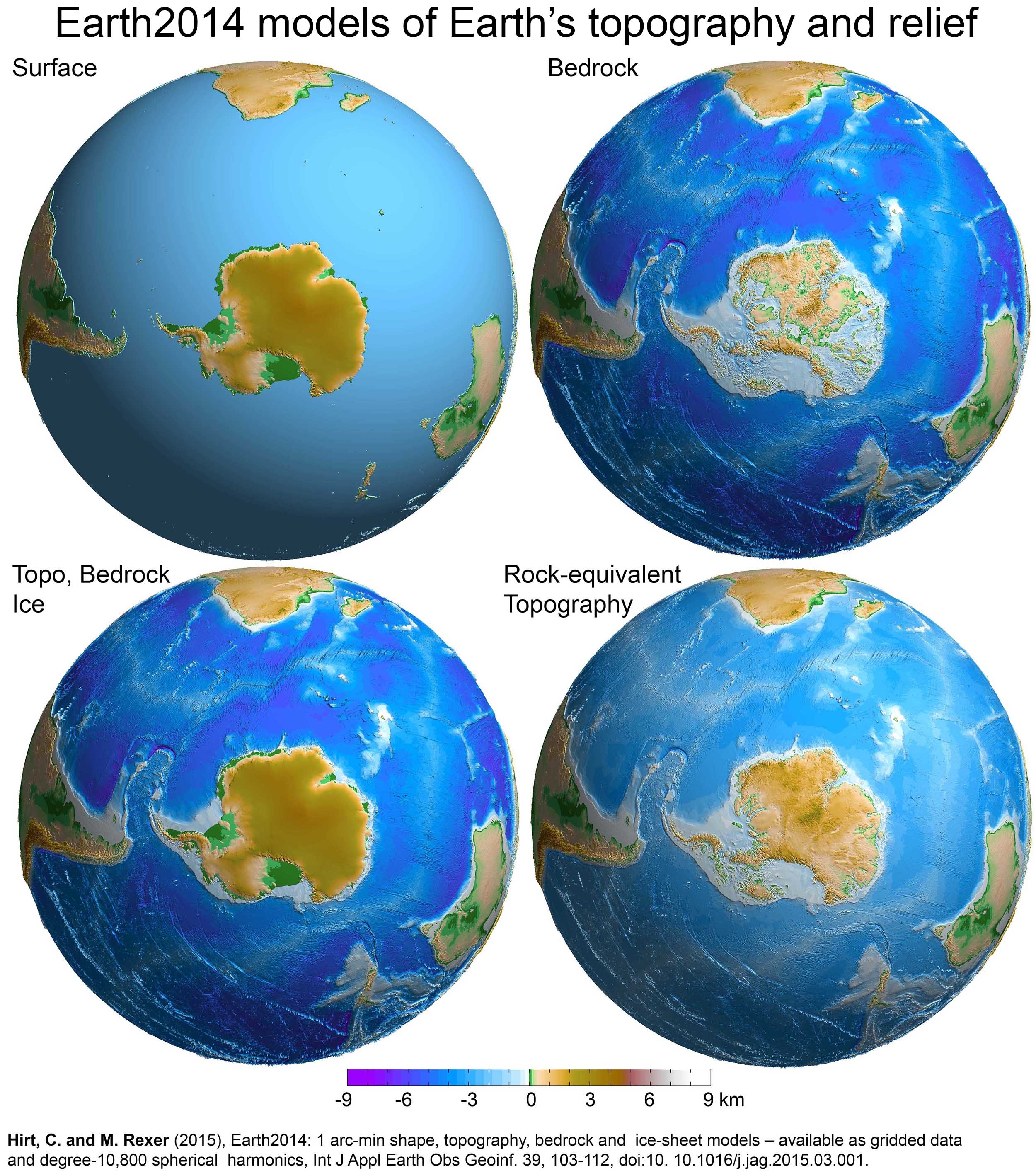
3 Antarctica 12,272,800[Note 11] 4,738,600 None Seven countries have made eight territorial claims. All territorial claims in Antarctica are in abeyance under the Antarctic Treaty System.

Antarctica is a special case, for if its ice is considered not as land, but as water, it is not a single landmass, but several landmasses of much smaller area, since the ice-bedrock boundary is below sea level in many regions of the continent.[13] If its ice cover were to be lifted, some rocks that are currently below sea level would rise as the weight of the ice would be removed,[14] although this would in part be counteracted, and in some areas of the continent overtaken, by eustatic rises in sea level.[15]
4 Mainland Australia 7,591,608[Note 12] 2,931,136 Australia Mainland Australia is more than three times the size of Greenland, the largest island.[17] Australia is sometimes dubbed "The Island Continent" or "Earth's largest island, but its smallest continent".[18]
Dymaxion map (Fuller map) with continental landmasses (I,II,III,IV) and largest islands (1–30) roughly to scale

See also

[edit]

Notes

[edit]

References

[edit]
Revisions and contributorsEdit on WikipediaRead on Wikipedia
from Grokipedia

A landmass is a large, continuous region of continental crust emerging above sea level, forming distinct areas such as continents or major islands that are geologically cohesive and separated by oceans or other barriers.
Earth's landmasses collectively occupy about 148.9 million square kilometers, representing roughly 29% of the planet's total surface area, with the remainder covered by oceans and other water bodies.
These landmasses have formed and evolved through tectonic processes driven by plate tectonics, including the assembly and breakup of supercontinents like Pangaea approximately 200-225 million years ago, which fragmented into the current configuration over geological time.
Key landmasses include Afro-Eurasia, the largest contiguous expanse spanning Africa, Europe, and Asia, which influences global climate patterns, biodiversity hotspots, and human population distribution due to its vast size and diverse topography.
Tectonic activity continues to shape landmasses today, producing features like mountain ranges, rift valleys, and volcanoes through convergence, divergence, and lateral sliding of lithospheric plates.

Definition and Characteristics

Core Definition

A landmass refers to a large, continuous area of land, such as a or subcontinent, that remains intact without significant interruption by oceanic barriers. Geologically, it encompasses portions of the continental crust situated above , possessing a distinct geophysical and topographic identity separate from surrounding marine environments. This distinguishes landmasses from smaller features like islands or peninsulas, which may share continental shelves but lack the scale or autonomy of primary landmasses. Earth's aggregate landmass totals approximately 148.94 million square kilometers, constituting 29.2% of the planet's overall surface area of 510 million square kilometers. This land is predominantly continental, with the seven conventionally recognized continents—, , , , , , and —forming the core divisions, though debates persist regarding the precise demarcation of Europe and Asia as separate entities. Landmasses exhibit varied elevations, from sea-level plains to high plateaus and mountain ranges, shaped by endogenous processes like uplift and exogenous factors such as .

Physical and Geological Traits

Landmasses, comprising the Earth's continental areas, are underlain by that averages 30 to 50 kilometers in thickness, in contrast to the thinner of 5 to 10 kilometers. This crust exhibits a of approximately 2.7 grams per cubic centimeter, lower than the 3.0 grams per cubic centimeter of , which contributes to the buoyant elevation of landmasses through isostatic balance on the denser mantle below. Compositionally, the upper continental crust is dominated by igneous and metamorphic rocks such as and , rich in silica and aluminum (sialic materials), while the lower crust transitions to more types with densities up to 3.25 grams per cubic centimeter. Geologically, landmasses display pronounced topographic relief, with average elevations around 1 kilometer above , featuring extensive mountain ranges, plateaus, plains, and river networks shaped by long-term and deposition. Stable cratonic cores, often in age exceeding 1 billion years, form the resistant heartlands resistant to deformation, surrounded by younger orogenic belts where tectonic compression has folded and thrust ancient sediments into high ranges like the . velocities through average 6.5 kilometers per second for compressional waves, reflecting its heterogeneous structure of layered igneous intrusions, metamorphic complexes, and sedimentary covers. These traits distinguish landmasses from oceanic basins, as continental materials resist due to their low and , preserving a geologic record spanning billions of years in contrast to the perpetually recycled . Passive margins, such as those along the Atlantic coasts, exhibit minimal tectonic activity with broad shelves and minimal , while active margins host subduction-related and faulting. Overall, the physical endurance of landmasses arises from their compositional lightness and thickness, enabling persistence amid and plate motions.

Geological Origins and Evolution

Plate Tectonics Framework

The theory of describes Earth's outermost layer, the , as fragmented into a dozen or more large and small rigid plates that move relative to one another at rates typically ranging from 1 to 10 centimeters per year. These plates float on the semi-fluid beneath, driven primarily by thermal currents in , where hotter material rises and cooler material sinks, along with forces like ridge push and slab pull at subduction zones. In this framework, landmasses—composed mainly of buoyant, granitic —are embedded within these plates and do not subduct easily due to their lower density compared to oceanic , allowing them to persist and relocate over hundreds of millions of years. Plate boundaries classify interactions as divergent, where plates separate and new crust forms via upwelling magma (e.g., mid-ocean ridges); convergent, where plates collide, leading to subduction of oceanic crust or continental collision that builds mountain ranges like the Himalayas; and transform, where plates slide past each other, generating strike-slip faults. This dynamic reshapes landmasses: divergent boundaries can rift continents apart, as seen in the ongoing separation of East Africa, while convergent collisions amalgamate terranes into larger cratons, forming stable continental cores. Over geological timescales, such processes have cycled landmasses through supercontinent assemblies and dispersals, with the most recent supercontinent, Pangaea, fragmenting approximately 225-200 million years ago into the configurations observed today. Empirical support for this framework includes seafloor magnetic anomalies revealing symmetric stripes of reversed polarity, confirming spreading from mid-ocean ridges at rates matching plate motions; paleomagnetic data showing continental wander paths inconsistent with polar shifts; and biogeographical matches, such as identical fossil assemblages of in and , indicating former adjacency. and volcanic distributions align precisely with plate edges, with deep-focus quakes tracing zones up to 700 kilometers deep. These lines of evidence, integrated since the following Harry Hess's hypothesis and Vine-Mathews paleomagnetic correlations, unify observations of landmass evolution previously explained ad hoc, demonstrating causal links from mantle dynamics to surface without reliance on unverified mechanisms.

Formation Processes and Evidence

The formation of continental landmasses began in the and eons through the differentiation of , where generated primitive basaltic crust that evolved into sialic (granitic) compositions via processes such as intracrustal melting and fractionation. Evidence for this early crust includes detrital crystals from , , dated via U-Pb radiometric methods to 4.404 billion years ago, representing the oldest known terrestrial material and indicating stabilization of proto-continents shortly after the Moon-forming impact around 4.5 billion years ago. Intact rock suites, such as the in , yield ages of approximately 4.03 billion years through similar zircon geochronology, preserving tonalite-trondhjemite-granodiorite (TTG) assemblages characteristic of early continental nuclei formed under high-pressure, water-present conditions. Subsequent growth of landmasses primarily occurs through subduction-related mechanisms within the framework, where descending oceanic slabs dehydrate and flux in the overlying mantle wedge, generating andesitic to dacitic magmas that form volcanic arcs accreted to continental margins. This arc magmatism contributes juvenile (mantle-derived) material, with estimates suggesting that 50-80% of post-Archean growth stems from such additions, supplemented by sedimentary recycling and lower crustal . Geological evidence includes complexes, such as those in the of or the Semail Ophiolite in , which preserve fossilized oceanic lithosphere and zones, with radiometric ages aligning with arc-building episodes; isotopic studies (e.g., Nd and Hf) further distinguish juvenile inputs from reworked crust, showing net growth rates of 0.5-2 km³/year globally since the . reveals modern slabs extending to the , corroborating historical analogs through imaged ancient subducted material. Continental collisions during convergence amplify landmass assembly by shortening and thickening crust, as seen in orogenic belts where buoyant continental lithosphere resists , leading to uplift and preservation of older crust interiors. The ongoing India-Eurasia collision, initiated around 50 million years ago, exemplifies this, with the Himalayan syntaxes and resulting from ~2000 km of convergence documented via GPS measurements and balanced cross-sections. Evidence from ancient examples includes linear suture zones with high-pressure metamorphic rocks (e.g., eclogites) and deformational fabrics in the Appalachian or Variscan belts, dated to 400-300 million years ago, indicating assembly of Pangea; paleomagnetic data from these regions show latitudinal shifts consistent with plate motions. Supercontinent cycles represent episodic landmass coalescence and dispersal, driven by instabilities that promote around assembled cratons, followed by rifting. Cycles occur roughly every 300-500 million years, with (~1.1-0.75 billion years ago) and Pangea (~300-180 million years ago) evidenced by matching conjugate margins (e.g., South America-Africa fit with shared geological provinces), apparent paths from , and global orogenic pulses recorded in detrital age distributions peaking at cycle terminations. Geochemical proxies, such as strontium isotopes, show excursions tied to enhanced during supercontinent breakup, supporting causal links to tectonic reconfiguration.

Alternative Theories and Debates

One prominent alternative to the model for continental separation and landmass evolution is the hypothesis, which posits that the planet's radius has increased over geological time due to internal mass addition or phase changes, causing continents to diverge without significant or . Proposed by researchers like Samuel Warren Carey in the mid-20th century, this theory interpreted paleogeographic reconstructions of supercontinents like as fitting on a smaller , avoiding the need for lateral plate motion. However, it lacks a viable physical mechanism for sustained expansion, such as accretion from external sources, and is contradicted by paleomagnetic data showing consistent with plate motion rather than radial growth, as well as modern GPS measurements indicating no current net radius change. Within the broader paradigm, debates persist on the precise mechanisms of early formation, particularly before the onset of modern-style around 3-2.5 billion years ago. A 2024 study analyzing ancient crystals challenges the dominant arc-magmatism model—where subducting oceanic slabs partially melt to generate continental precursors—proposing instead that initial landmasses arose from widespread crustal melting driven by internal heat and mantle upwelling, delaying full . This "drip tectonics" variant suggests localized gravitational instabilities in thickened crust led to and recycling, rather than global networks, supported by seismic evidence of detached lower crustal layers in modern orogens. Such models reconcile craton stability with limited traces, though they remain contested against evidence from ophiolites and terrains indicating early plate-like behavior as far back as 4 billion years. Another area of contention involves the role of mantle plumes versus in assembly and breakup cycles, with some geodynamic simulations arguing that plume-driven vertical tectonics dominated pre-Mesozoic landmass evolution, forming proto-continents through basaltic underplating rather than collisional orogenesis. These alternatives highlight empirical gaps in ' explanatory power for Hadean-Archean transitions, where stagnant-lid convection may have prevailed on a hotter , but they do not supplant the theory's core predictions, validated by seafloor age gradients and hotspot tracks. Mainstream acceptance favors hybrid models integrating plumes with plates, as pure alternatives fail to account for the full spectrum of isotopic and structural data from continental margins.

Classification Systems

Criteria and Methodologies

Geological criteria form the foundation for classifying major landmasses as continents, emphasizing distinctions in crustal structure and composition. , typically averaging 35-40 km in thickness and dominated by (silica-rich) rocks such as , contrasts sharply with oceanic crust's 6-7 km average thickness and basaltic composition, enabling identification of discrete continental blocks through and differences. Additional geological markers include the presence of ancient cratonic cores—stable, Precambrian-age shields—and a diverse assemblage of igneous, metamorphic, and sedimentary rocks, which reflect prolonged tectonic evolution distinct from oceanic settings. Physiographic criteria supplement by assessing scale and isolation, defining continents as large, elevated landmasses (often exceeding 1 million km² in emergent area, though including shelves) separated by deep oceanic basins rather than shallow seas. This includes evaluating bathymetric relief, where continental margins rise above surrounding oceanic floors, and considering submerged extensions like continental shelves as integral to the landmass. While cultural or historical conventions influence regional models (e.g., treating and separately despite connectivity), scientific classification prioritizes empirical tectonic and lithospheric boundaries over arbitrary political divisions. Methodologies for delineation rely on geophysical and geological surveys to verify these criteria. and reflection profiling measure crustal thickness and profiles, distinguishing continental from oceanic domains via P-wave velocities (typically 6-7 km/s in upper vs. lower in oceanic). detects density anomalies from continental roots, while rock sampling and paleomagnetic analysis confirm lithologic diversity and historical stability; integrated altimetry and multibeam mapping further delineate submerged margins. These techniques, often combined in plate tectonic frameworks, allow reproducible identification, as demonstrated in recognizing submerged continents like through coordinated bathymetric, seismic, and geological data.

Debates on Continental Counts

The delineation of continents lacks a universally agreed-upon scientific criterion, leading to models ranging from four to seven primary landmasses, with decisions often blending geological features like extent and tectonic separation with historical and cultural conventions. Geologically, continents are defined by large aggregates of continental lithosphere distinct from , typically surrounded by water or separated by shallow seas, but no single metric—such as size thresholds or plate boundaries—yields a fixed count, as evidenced by the arbitrary nature of divisions like the between and . In geological perspectives, a four-continent model predominates, grouping , , and into (spanning 84 million km² on the Eurasian Plate), treating the as one despite the Isthmus of Panama's recent formation around 3 million years ago, and recognizing and (or ) as separate due to their isolation on distinct plates. This approach prioritizes tectonic continuity over surface separations, noting that and share the same and plate without a or dividing them, a convention traceable to distinctions rather than modern evidence from the onward. Cultural and educational models expand to five or six continents by separating (10.18 million km²) from (44.58 million km²) for historical reasons—rooted in Herodotus's 5th-century BCE ethnogeography—and often merging North and into "America" (42 million km² combined), as in French and some Latin American curricula where the seven-continent model (adding separate , North America, , and /) is viewed as Anglo-centric. The seven-continent framework, prevalent in U.S. education since the , further isolates despite its proximity to and includes , but critics argue it inflates counts by emphasizing narrow land bridges like the 50-km-wide or over geological unity. Emerging debates include Zealandia, a 4.9 million km² mostly submerged landmass (94% underwater) south of New Zealand, proposed as an eighth continent in 2017 after geophysical surveys confirmed its thick granitic crust (20-40 km), diverse geology, and tectonic independence from Australia and Antarctica, meeting criteria set by the International Union of Geological Sciences despite lacking significant exposed land. While geologists increasingly accept Zealandia—fully mapped by 2023 via seismic and bathymetric data—its recognition challenges surface-biased models, highlighting how 85% of Earth's continental crust remains hidden under seas, potentially implying more such entities.

Major Landmasses

Afro-Eurasia

Afro-Eurasia constitutes the largest continuous landmass on , integrating the continents of , , and into a single geophysical entity connected by the Isthmus of Suez and the . This configuration spans approximately 84,980,532 square kilometers, accounting for 57 percent of the planet's total land surface. As of 2023 estimates, it supports around 6.8 billion inhabitants, representing over 85 percent of global human population, with densities varying from sparsely populated Siberian to the high concentrations in the and . Geographically, Afro-Eurasia extends from the southern tip of at (34°52′S) northward across the , through the Mediterranean and into regions, reaching in at 77°43′N; longitudinally, it ranges from Iceland's eastern shores (13°25′W) to Cape Dezhnev (169°43′W). The landmass encompasses diverse physiographic features, including the Sahara Desert, the (averaging 4,500 meters elevation), the as a conventional Europe-Asia divide, and rift valleys in signaling ongoing tectonic activity. Human-engineered features like the , completed in 1869, artificially bisect the connection between and but do not alter the underlying continental continuity. Geologically, Afro-Eurasia reflects the convergence of the African, Arabian, Indian, and Eurasian tectonic plates over millions of years, with the African Plate moving northward at 2-3 cm annually toward the Eurasian Plate, fostering mountain-building in the Alps, Zagros, and Himalayas. Evidence from paleomagnetic studies and fossil distributions indicates that its core formed as part of the Gondwana supercontinent fragment, later amalgamating with Laurasian elements post-Pangaea breakup around 175 million years ago. This unity contrasts with the isolated Americas, enabling greater faunal interchange and evolutionary pressures, as evidenced by shared mammal lineages like bovids across its expanse since the Miocene epoch. In terms of biodiversity hotspots, hosts over 80 percent of terrestrial , driven by its climatic gradients from equatorial rainforests in the to Mediterranean shrublands, though anthropogenic pressures have led to loss rates exceeding 1 percent annually in regions like . Its landmass configuration has facilitated human dispersal from African origins around 60,000-100,000 years ago, with genetic evidence from tracing non-African lineages to a single Out-of-Africa migration event. Resource extraction, including fossil fuels from the and minerals from the African Rift, underscores its economic centrality, supplying 70 percent of global oil reserves.

The Americas

The Americas encompass , , and as a single continuous landmass linked by the , extending latitudinally from about 83°N at on to 55°S at , with longitudinal bounds primarily between 25°W and 130°W. This configuration positions the landmass as the second-largest coherent continental entity after , with a total land area of 42.55 million km², representing approximately 28.5% of Earth's terrestrial surface. The eastern margin abuts the Atlantic Ocean, while the western edge interfaces with the , and northern and southern extremities reach the and Southern Oceans, respectively. Tectonically, the Americas originated from the fragmentation of during the to periods, around 200 million years ago, when rifting separated the western portion—comprising the (core of ) and elements of (precursor to )—from eastern landmasses, initiating in the Central Atlantic and subsequent divergence of the North American, South American, and plates. This process continued through the , with along the western margins driving the accretion of terranes and formation of the Cordilleran . Evidence from paleomagnetic data, of rift basalts, and stratigraphic records of marine transgressions supports this timeline, with the stable cratonic interiors (e.g., ) preserving to basement rocks dating back over 3 billion years. A pivotal late development was the tectonic uplift and closure of the around 3.5 million years ago, which restricted marine circulation between the Pacific and Atlantic, altered ocean currents including the proto-Gulf Stream, and enabled terrestrial migration corridors for biotic exchange. This event, corroborated by microfossil assemblages in near-shore sediments from and , intensified regional aridity in northern and facilitated faunal interchanges, such as northward expansion of South American mammals and southward movement of North American carnivores. Dominant physiographic features reflect plate interactions: in , the forms a vast, eroded core exposed over 8 million km², flanked eastward by the Appalachian orogen (formed 400–300 million years ago via collisions with Euramerica fragments) and westward by the Laramide-influenced and from and extension since the . South America's features the stable Brazilian Shield, the Andean chain—spanning 7,000 km and exceeding 6,000 m in at due to ongoing of the Nazca Plate at 6–10 cm/year—and ancient Patagonian massifs. These structures, shaped by convergent margins, host significant seismic activity, with the Americas experiencing over 15% of global earthquakes annually along the Pacific segment.

Other Continents

, the fifth-largest continental landmass, spans approximately 14 million square kilometers, with over 98% covered by ice averaging 1,900 meters thick. Its geology divides into , featuring a with rocks dating to 4 billion years old, and , characterized by younger mobile belts and Andean-style along its margins. Formed as part of the , began separating from other southern continents around 180 million years ago during the breakup driven by , leading to its isolation and the onset of widespread glaciation by 34 million years ago. Australia constitutes the smallest continental landmass at 7,688,287 square kilometers, comprising ancient cratons such as the and Yilgarn, which assembled around 2.2 billion years ago during the Capricorn Orogeny. Its geological record includes detrital zircons up to 4.4 billion years old, among the oldest terrestrial materials, reflecting prolonged stability with minimal deformation since the . Like , Australia originated within , detaching progressively from around 160 million years ago and from later, resulting in its current position on the Indo-Australian Plate with associated intraplate stresses and arid interior dominated by shields. These landmasses, isolated by vast oceans, exhibit low compared to or the due to their tectonic histories and climatic extremes, with Antarctica's holding about 90% of Earth's freshwater and influencing global sea levels and ocean circulation. Australia's flat and ancient have shaped its unique ecosystems, though since 65,000 years ago has altered landscapes through and . Debates persist on additional submerged landmasses like , proposed as a based on crustal thickness exceeding 20 kilometers over 4.9 million square kilometers, but it lacks the exposed land area of traditional continents.

Subcontinents, Peninsulas, and Large Islands

Defining Subdivisions

A subcontinent constitutes a major physiographic subdivision of a , characterized by a large landmass that is geographically or tectonically distinct from the surrounding continental body, often separated by prominent barriers such as mountain ranges, straits, or tectonic plate boundaries. Unlike full , which are defined by extensive and shelves spanning tens of millions of square kilometers, subcontinents typically encompass areas on the order of millions of square kilometers but remain tectonically linked to the parent continent. This distinction arises from causal geological processes, such as plate collisions creating isolating features; for example, the , covering approximately 4.4 million square kilometers, detached from and collided with around 50-55 million years ago, uplifting the as a barrier. Peninsulas represent protruding subdivisions of continental landmasses, defined as portions of land extending into surrounding water bodies, connected to the mainland along one side (often via an ) and bordered by water on the other three sides, resulting from erosional, depositional, or tectonic sculpting of coastal margins. This configuration contrasts with islands by maintaining terrestrial continuity, enabling shared geological substrates like , though peninsulas can exhibit semi-isolated climates or biomes due to maritime exposure. The , spanning about 583,254 square kilometers, exemplifies this, jutting westward from into the Atlantic and Mediterranean, shaped by the and subsequent fluvial erosion. Large islands qualify as significant detached subdivisions when their land area exceeds thresholds that invite comparison to subcontinents or minor continents—typically over 100,000 square kilometers—yet they lack the full continental attributes of vast shelves or independent cratonic cores, often forming on or peripheral shelves through volcanic, , or glacial processes. Empirical classification relies on area measurements from satellite surveys and bathymetric data, excluding submerged features; , at 2,166,086 square kilometers, stands as the largest, its ice-covered terrain atop Precambrian rocks linking it geologically to , but its encirclement by and Atlantic waters and absence of broad shelf extension affirm island status over continental. Such islands influence regional ocean currents and biodiversity gradients, as their isolation fosters endemic species via , distinct from the interconnected ecosystems of peninsular or subcontinental extensions. These subdivisions blur at edges due to arbitrary size cutoffs and hybrid geologies—e.g., at 4.9 million square kilometers is mostly submerged, disqualifying it as a land island—necessitating multidisciplinary criteria combining area, crust type, and isolation metrics from geophysical surveys rather than purely political or cultural lenses.

Key Examples

The exemplifies a subcontinent, encompassing roughly 4.4 million square kilometers across , , , , , and the , geologically isolated from mainland by the Himalayan orogenic belt resulting from the Indian Plate's northward collision with the Eurasian Plate beginning approximately 50-55 million years ago. This tectonic separation, evidenced by seismic and paleomagnetic data, creates a distinct projecting into the , influencing patterns and hotspots like the . The , covering 3.2 million square kilometers, serves as another key example, tectonically distinct on the Arabian Plate, which rifted from around 25 million years ago, forming the and through documented in geophysical surveys. Its arid interior, including the Rub' al-Khali desert basin exceeding 650,000 square kilometers, underscores its role as a major landmass with limited connectivity to surrounding regions via narrow straits. Prominent peninsulas include the Deccan Peninsula, spanning about 800,000 square kilometers in southern , overlain by the —a vast province erupted 66 million years ago, linked to the Cretaceous-Paleogene extinction event via iridium anomalies and in stratigraphic layers. The Indochinese Peninsula, approximately 1.9 million square kilometers, projects southeast from , encompassing , , , , , and parts of southern China, shaped by Indosinian and . Large islands qualifying as significant landmasses include , the world's largest at 2,130,800 square kilometers, 80-85% ice-covered with an volume of 2.85 million cubic kilometers, contributing to global sea-level rise potential of 7.4 meters if fully melted, as measured by satellite altimetry and GRACE . , at 785,753 square kilometers, ranks second, bisected by the Owen Stanley Range and hosting over 1,000 endemic bird species due to its isolation post-Pleistocene glaciation. , 743,168 square kilometers, features diverse rainforests with peat swamp ecosystems storing 6-8% of global peat carbon, divided among , , and . These islands, defined by surrounding oceanic shelves rather than extension, contrast with microcontinents like , which is 94% submerged.

Broader Implications

Influence on Climate and Biodiversity

The configuration of landmasses profoundly shapes global and regional climates through their influence on atmospheric and oceanic circulation patterns. Land surfaces heat and cool more rapidly than oceans due to differences in heat capacity, resulting in greater seasonal temperature extremes in continental interiors compared to coastal areas. For example, the expansive Eurasian landmass experiences temperature ranges exceeding 60°C annually in Siberia, driven by its distance from moderating ocean influences. Similarly, the positioning of continents alters ocean currents; the closure of the Isthmus of Panama approximately 3 million years ago redirected Atlantic and Pacific flows, strengthening the Gulf Stream and contributing to cooler Northern Hemisphere climates. Large tropical land concentrations can enhance silicate weathering, drawing down atmospheric CO2 and potentially cooling the planet over geological timescales. Continental geometry also affects precipitation distribution by modulating circulation and monsoon dynamics. Vast landmasses disrupt zonal winds, fostering arid interiors like the , where orographic effects and rain shadows from mountain ranges such as the exacerbate dryness. Supercontinent assemblies reduce coastal perimeters, diminishing moisture influx and expanding continental deserts, as seen in models of past configurations like . In contrast, fragmented landmasses near equatorward oceans promote wetter equatorial climates through enhanced . Landmass distribution influences by determining connectivity, area, and isolation, which drive and rates. Larger continents provide expansive habitats supporting higher via the species-area relationship, where diversity scales logarithmically with area; Afro-Eurasia's 54 million km² correlates with its mammalian species count exceeding 500, far surpassing isolated . Isolation from fosters endemism through vicariance, as the separation of led to unique radiations in and , with marsupials dominating the latter. Continental gateways, such as the Bering during glacial periods, periodically connect faunas, enabling dispersals that homogenize diversity but also spark adaptive radiations upon re-isolation. Tectonic rearrangements regulate marine biodiversity by altering shallow shelf areas and connectivity; for instance, breakup increases epicontinental seas, boosting in groups like ammonites during the . Current configurations, with continents clustered in the , concentrate terrestrial diversity there, while Southern Hemisphere isolation preserves relict lineages. Climatic gradients induced by landmasses, such as rain shadows creating diverse microhabitats, further amplify local .

Human Utilization and Impacts

Human utilization of landmasses has primarily involved , which covered 4.8 billion hectares in 2023, comprising more than one-third of the Earth's total area of approximately 13 billion hectares. This includes 1.5 billion hectares of for crops and 3.3 billion hectares of permanent pastures, enabling the support of a global exceeding 8 billion through food production. Urban development occupies a smaller , estimated at less than 1% of global , yet accommodates over half the world's in concentrated settlements. and resource extraction, such as and , further modify landscapes, with managed forests contributing to timber supply and economic output. These activities have driven by facilitating specialization, , and technological advancements in , which have increased yields and reduced the land requirement for food production despite population expansion. For instance, global cropland has declined by about 44% since the mid-20th century due to gains, allowing land reallocation toward other uses. On continental scales, utilization varies: in , and dominate, supporting dense populations, while in the , expansive and ranching prevail, particularly in . Impacts include accelerated soil erosion from agricultural practices, with human activities increasing continental erosion rates by factors of 10 to 100 times natural levels in many regions. , largely for agricultural expansion, resulted in a global net loss of 4.7 million hectares annually between 2010 and 2020, concentrated in tropical continents like and , though rates have slowed in some areas such as , where losses dropped by nearly one-third from 2023 to 2024. Conversely, temperate regions like have seen recovery, with area increasing post- due to and reduced demand for fuelwood. Human modification affects over 50% of ice-free land surface, altering and , yet intensification has spared additional conversion compared to extensification scenarios.

References

Add your contribution
Related Hubs
User Avatar
No comments yet.