Hubbry Logo
Low-water crossingLow-water crossingMain
Open search
Low-water crossing
Community hub
Low-water crossing
logo
8 pages, 0 posts
0 subscribers
Be the first to start a discussion here.
Low-water crossing
Low-water crossing
from Wikipedia
A low-water crossing in Fargo, North Dakota, United States of America during a routine flooding event on the Red River of the North. The water level was at 29.5', just below the threshold for a major flood as defined by the National Weather Service.
Low-water crossing (vented ford) at Chew Stoke, Somerset, United Kingdom
Roanoke River low water bridge, USA
The drovers' road from Abergwesyn to Tregaron, Wales, United Kingdom, crosses the Afon Irfon via the Irish bridge at the foot of the Devil's Staircase
Shared pedestrian/cycle way over the Yass River in Yass, New South Wales, Australia

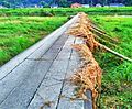
A low-water crossing (also known as an Irish bridge or Irish Crossing, causeway in Australia, low-level crossing or low-water bridge) is a low-elevation roadway traversing over a waterbody that stays dry above the water when the flow is low, but is designed to be submerged under high-flow conditions such as floods. This type of crossing is much cheaper to build than a high bridge that keeps the road surface consistently above the highest water level, and is usually deployed in semi-arid areas where high-volume rainfall is rare and the existing channel is shallow (which requires extra ramping on the banks to build a more elevated bridge and thus costs more), particularly in developing countries.

Low-water crossings are essentially elevated floodways, functioning like causeways under normal conditions and serving as limited fords during high-discharge conditions. They are generally considered unsafe for traffic during floods due to the potentially fast and turbulent currents flowing over the road surface, and can be dangerous even after the flood has receded because silt, mud and debris left on the road by the water can reduce traction and cause skidding risks for both vehicles and pedestrians.

In Japan, a Konnyaku bridge is a type of low-water crossing.

Construction

[edit]

The low-water crossing was developed from the traditional ford. A ford permits vehicular traffic to cross a waterway with wet wheels. In some countries the term “low-water crossing” implies that the crossing is usually dry, while “ford” implies that the crossing is usually wet.

The simplest type of low water crossing is called an unvented ford or drift. This type of low water crossing is used mainly for shallow waterways or dry streambeds. It consists of an improved surface of gravel, gravel-filled geotextile grid, paving blocks, or concrete slabs positioned to match the slope and elevation of the adjacent waterway and floodplain.

To cross somewhat deeper waterways, a type of low water crossing called a vented ford can be constructed with culverts. The size of the culverts (often concrete pipes) is usually selected to allow the water to flow below the roadway and provide a dry crossing surface for most of the year. During periods of high water flow (e.g. spring runoff or flash floods), water will flow over the top of the crossing, as the culverts are not large enough to carry these flood-type runoff events.

A more elaborate low-water bridge will usually be an engineered concrete structure. There are thousands of such structures in the arid climates of the western United States; some of them accommodate four-lane city streets or highways. Typically, a low-water bridge that accommodates a high daily volume of vehicular traffic will be underwater only a few days per decade.

[edit]

A low-water bridge renders the waterway non-navigable. In almost all cases this is not a practical concern, since the waterway would be non-navigable except during flood conditions anyway.

A low-water bridge is sometimes called a submersible bridge, but this is a misnomer. A true submersible bridge is used on navigable waterways and is actively lowered into the water.

Safety

[edit]

The concept behind low-water crossings is that they are convenient and safe to use in normal conditions. Once the water level rises to the point where it crosses the bridge surface, the bridge is generally unsafe to use due to high current. The force of the moving water may be strong enough to physically push the vehicle off the bridge: the higher the percentage of the vehicle in the water, the more likely the water's force will take the vehicle off the bridge and send it downriver with substantial damage. An additional risk for trying to cross a bridge under water, especially when more than a couple of feet deep, is the possibility of the vehicle's engine stalling. As people will typically try to then get out of the vehicle, they may step into water currents that cause them to fall or be pulled down into the water. As the current during floods is often quite strong, it may sweep them downriver and carry them into debris, possibly causing injury or death.

In developed countries this will usually be indicated by warning signs. An additional hazard is that the bridge surface may become completely obscured by the water, making it relatively easy to fall off the bridge surface into the deeper and more hazardous water on either side. As a consequence, the line of the submerged bridge is often marked with poles or other structures to indicate its course to unwary travelers and emergency users even when submerged.

Despite the obvious dangers and warnings given there are still a significant number of emergencies and even deaths attributable to the unwary use of low-water bridges during flood conditions.

One attempted solution/deterrent is the Stupid motorist law in the American state of Arizona. Drivers who become stranded on flooded low-water bridges are charged with the cost incurred by emergency services to come to their rescue.

Fish passage at low-water crossings

[edit]

Since 1980, the ecological impact of road crossings on natural streams and rivers has been recognised. Baffles may be installed along the culvert to provide some fish-friendly alternative.[1][2] But baffles can reduce drastically the culvert discharge capacity for a given afflux,[3] thus increasing substantially the total cost of the culvert structure to achieve the same design discharge and afflux, or increasing the risk of road flooding in an existing structure.

References

[edit]

Further reading

[edit]
[edit]
Revisions and contributorsEdit on WikipediaRead on Wikipedia
from Grokipedia
A low-water crossing is a road-stream crossing structure designed to be overtopped by high flows, debris, or ice-laden flows, typically used on very low-volume rural roads or trails where traffic is less than 25 vehicles per day. These structures function as dry or low-water passages during normal conditions, allowing vehicles to cross at or near the streambed elevation, but they intentionally flood during moderate to high water events to prevent damage from excessive hydraulic forces that could affect more expensive alternatives like bridges or culverts. As an economical and environmentally friendlier option, low-water crossings minimize long-term maintenance costs and habitat disruption compared to traditional infrastructure, though they require careful site selection to balance functionality and risks.

Definition and Types

Definition

A low-water crossing (LWC), also known as a low-water bridge, Irish bridge, or , is a roadway that allows vehicles to cross a or riverbed at or near the surface, designed to be submerged or overtopped during moderate to high flows but passable during low or dry conditions. These structures are engineered as open-bottom or low-elevation features that prioritize hydraulic efficiency over constant elevation above flood levels. The primary purpose of a low-water crossing is to serve as a cost-effective alternative to full bridges for low-traffic rural roads, floodplains, or seasonal , balancing with the natural flow of and minimizing environmental impacts. By allowing overtopping during floods, LWCs reduce construction and maintenance costs while facilitating and aquatic passage, making them suitable for areas with infrequent high flows. They are particularly advantageous in arid or semi-arid regions where flash floods are short-duration events, enabling stormproofing without extensive . Low-water crossings originated in arid and semi-arid regions to conserve and minimize disruption to natural watercourses, with first documented uses appearing in 19th-century rural in the United States, such as along cattle trails crossing rivers at shallow points. Designs evolved from traditional fords into engineered crossings. Key characteristics of low-water crossings include a depressed roadway section with minimal above the streambed, typically using stable surfaces like rock or to support traffic while permitting unimpeded water and passage without significant impoundment. This configuration ensures the structure functions as a partial ford under normal conditions, enhancing ecological connectivity in stream systems. Various types exist, including unvented fords, vented fords, and low-water bridges, as detailed in subsequent sections.

Types

Low-water crossings are categorized into three primary types based on their structural design and capacity to handle stream flows: unvented fords, vented fords, and low-water bridges. These variants differ in how they manage water passage, with unvented fords relying entirely on overtopping, vented fords incorporating partial drainage structures, and low-water bridges providing elevated durability for occasional submersion. Selection depends on factors such as stream hydrology, traffic volume, and environmental conditions. Unvented fords, also known as at-grade or simple fords, consist of a depressed roadway aligned with the natural streambed, typically armored with , gabions, or concrete to prevent , without any culverts or vents. During low flows, vehicles cross on a dry or shallow surface, but the structure is fully overtopped during higher flows, leading to frequent closures. They are suitable for very low- areas, such as ephemeral or intermittent streams with low velocities, and paths for or access. Advantages include minimal construction costs and preservation of natural stream flow dynamics, while disadvantages encompass risks from high-velocity flows, channel widening due to , and the need for periodic to replace finer aggregates washed away. Vented fords feature a raised roadway with small , culverts, or similar vents embedded beneath to allow low to moderate flows to pass underneath without full submersion of the crossing surface. Higher flows overtop the , but the vents reduce water depth on the roadway during typical conditions. This type is appropriate for moderate-flow and low-volume roads where partial drainage is needed to maintain access. Benefits include better vehicle safety by keeping the surface drier for longer periods and support for some aquatic passage through vents, though drawbacks involve potential clogging of pipes with debris, upstream if vent capacity is insufficient, and ongoing maintenance requirements. Low-water bridges elevate a or deck slightly above the streambed, often with additional vents or openings, designed to be overtopped and withstand periodic flooding without structural failure. The deck may incorporate articulated concrete blocks or around supports to enhance . These are ideal for vehicular roads with higher volumes crossing broader channels prone to occasional flooding. Strengths lie in their , minimal disruption to channel morphology, and ability to handle debris-laden flows, whereas limitations include higher initial costs and potential issues from overtopping, such as reduced or railings that may trap .
TypeProsConsTypical ApplicationsHydraulic Thresholds
Unvented FordLow cost; easy construction; natural flow preservationFrequent closures; and channel alteration risksEphemeral ; low-traffic/ paths (<5 vehicles/day)Designed for overtopping in 10-25 year floods; max depth ~0.5 ft during low flows
Vented FordPartial drainage for drier surface; supports some aquatic passageDebris clogging; maintenance needs; sedimentation potentialModerate-flow ; low-volume roadsVents handle low flows; overtopping up to 6 inches in 10-25 year floods
Low-Water BridgeDurable for submersion; good channel function; handles higher traffic/debrisHigh cost; overtopping safety concernsVehicular roads; broader channels with variable flows (>5 vehicles/day)Designed for overtopping during 10-25 year floods with minimal damage

Design and Construction

Design Principles

The design of low-water crossings begins with a comprehensive hydrologic to establish levels and ensure the structure remains passable during typical conditions while accommodating overtopping during higher flows. Engineers determine design events, such as the 10-year and 50-year , using rainfall-runoff models like HEC-HMS or regional regression equations based on drainage area and exceedance probability, where discharge Qe=aAbQ_e = a A^b with aa and bb as regional coefficients and AA as the watershed area in square miles. The crossing is set to allow unimpeded passage at base flow or low exceedance probabilities (e.g., 95%), but it submerges during the Q2 flow, defined as the 50% annual exceedance probability or median flow, to prevent excessive scour while maintaining hydraulic capacity. Geotechnical considerations are critical to address soil stability, scour potential, and foundation design, particularly in erodible streambeds. Site investigations evaluate bearing capacity and erosion risk, incorporating measures like riprap aprons or gabion baskets to protect against undermining. Scour depth dsd_s is estimated using simplified hydraulic principles, such as ds=kV22gd_s = k \cdot \frac{V^2}{2g}, where dsd_s is scour depth, VV is , gg is , and kk is an empirical accounting for bed material and flow conditions; this approach draws from velocity head-based models to predict local scour around the structure. Foundations are designed with deep pilings or keyed abutments in unstable to resist lateral forces and settlement during events. Structural loading accounts for vehicle-induced stresses, with designs typically adhering to AASHTO HS-20 standards, which specify a 32,000-pound (equivalent to an 80,000-pound ) distributed across the crossing surface to ensure durability under low-volume traffic. For vented fords or low-water bridges, the pavement or slab must distribute this load to prevent cracking, often using with a minimum 6- to 12-inch aggregate base. Alignment with stream banks minimizes flow velocity concentration, reducing hydrodynamic forces on the structure during partial inundation. Site selection emphasizes locations with low-gradient (typically less than 2%) to limit flow velocities and , average daily (ADT) under 200 vehicles per day, with lower volumes (e.g., under 25) preferred to justify the overtopping risk, and avoidance of habitats for migratory to minimize ecological disruption. These criteria ensure economic viability and , prioritizing stable, straight reaches over ephemeral or flashy channels where feasible.

Construction Methods

Construction of low-water crossings begins with thorough site preparation to ensure stability and minimize environmental disturbance during installation. The streambed is excavated to its natural grade, removing accumulated debris, soft organic soils, and unstable materials to create a firm foundation. Approaches to the crossing are stabilized using —angular stone placed along banks and edges—to prevent and flanking during high flows. Soft soils are replaced with a 1- to 2-foot layer of select , which is then compacted to at least 90% of AASHTO T-99 density (equivalent to standard Proctor) to achieve adequate load-bearing capacity. is essential, often accomplished by constructing a temporary upstream cutoff or , supplemented by a 12- to 24-inch to reroute low flows around the work area. Material selection prioritizes durability against hydraulic forces, abrasion, and uplift while accommodating the crossing's low-profile design. Reinforced concrete slabs, typically 6 to 8 inches thick, are commonly used for the driving surface due to their strength and , often spanning over embedded culverts in vented configurations. Articulated concrete blocks (ACBs) provide flexible , consisting of interlocking precast units—such as 1-foot-square blocks connected by cables or —that form mats resistant to differential movement and scour. Geosynthetic reinforcements, including (e.g., 6 oz/yd² needle-punched fabric) as filters beneath or geocells to confine aggregate, enhance stability without rigid structures. For vented types, culverts like structural boxes or corrugated metal pipes (24 to 48 inches in diameter) are selected to convey design flows while maintaining a natural streambed profile. Installation techniques emphasize precision to integrate the structure with the stream environment. is prepared and compacted to 95% standard density before placing materials, ensuring resistance to settlement under traffic and flood loads. In-situ pouring of slabs occurs directly over footings or culverts, with forms anchored below potential scour depths (e.g., 2-foot-wide spread footings). Precast units, such as ACB mats or concrete planks, are positioned and interlocked on a filter layer, allowing flexibility for minor channel shifts. Vented crossings incorporate culverts embedded 1 to 2 feet with local streambed for seamless integration, aligned to the channel; these are backfilled and topped with aggregate or slabs, compacted in lifts to prevent voids. Approaches are armored with aprons extending 1.5 times the waterfall height downstream. Modular precast elements facilitate construction in remote sites, reducing on-site labor and equipment needs. Cost factors for low-water crossings vary based on span length (typically 10 to 50 feet), materials, and site accessibility, with total expenses ranging from $50,000 to $200,000 per crossing. Simple unvented fords using local or aggregate are at the lower end, while vented designs with slabs and culverts increase costs due to and scour protection. Modular , leveraging precast ACBs or slabs, lowers expenses in remote areas by minimizing and assembly time. Local material sourcing, such as durable , further optimizes budgets compared to imported or gabions.

Operation and Navigation

Users approaching a low-water crossing should first assess conditions to ensure safe passage. Key protocols include measuring depth, which should not exceed 6 inches for safe passage with high-clearance , using installed depth gauges or visual aids like to avoid underestimation. Flow should be evaluated, as moving , even at shallow depths, significantly increases the risk of instability compared to still ; drivers are advised to avoid crossings where current is visibly strong. of the crossing, including clear sightlines to levels and road edges, is essential, particularly during low-light or adverse weather, with recommendations to halt and reassess if conditions obscure hazards. Vehicle suitability plays a critical role in safe navigation. High-clearance, four-wheel-drive (4WD) vehicles in low range are recommended for crossings, especially on uneven or submerged surfaces, to maintain traction and prevent stalling. Standard passenger cars should avoid crossings altogether if water exceeds minimal depths or if recent upstream has raised levels, as even 12 inches of moving water can carry away most vehicles. To minimize risks like hydroplaning or engine damage, drivers must adhere to reduced speeds of 5 miles per hour or less, allowing a controlled crossing while keeping momentum to avoid getting stuck. Regulatory aspects vary by region but emphasize compliance with and barriers. In , state mandates adherence to barriers at low-water crossings, with violations punishable by fines up to $2,000 and up to 180 days in jail; many sites include designated turn-around areas to facilitate safe reversal. follows the Texas Manual on Uniform Traffic Control Devices (TxMUTCD), including warnings like "ROAD MAY FLOOD" and "DO NOT CROSS WHEN FLOODED," with active systems such as flashing beacons for heightened alerts. Internationally, guidelines for rural paths, such as those from the (FAO), recommend crossings only where water depth remains under 0.5 meters and banks are stable, prioritizing low-impact access on low-volume routes without specific vehicle mandates but stressing avoidance during high flows. Temporary closures are implemented based on predefined thresholds to protect users. Protocols trigger shutdowns when water reaches 6-10 inches or during imminent , using physical , dynamic signs stating "ROAD CLOSED," or gates activated by sensors. Seasonal or event-based closures, such as after heavy rains, are communicated via local alert systems, mobile apps (e.g., flood monitoring tools in flood-prone areas), or roadside notifications to inform drivers of alternative routes.

Maintenance Requirements

Routine inspections of low-water crossings are essential to detect early signs of deterioration and ensure structural integrity. These typically occur annually, focusing on scour around foundations, accumulation of debris in vents or culverts, and cracking in pavement or concrete surfaces. Additional periodic checks, such as quarterly reviews in high-risk areas, assess roadway armoring and ditch stability to prevent sediment transport. Post-flood assessments must be conducted promptly after significant runoff events to evaluate damage, with inspections recommended within days to identify scour depth, , and structural shifts. These evaluations use field observations, probes, and sometimes hydraulic modeling to determine if immediate repairs are needed to restore functionality. Repair techniques vary by crossing type but commonly include clearing from culverts and vents to maintain hydraulic capacity, patching with high-strength materials compatible with original , and regrading approach roads to address . For scour protection, , gabions, or aprons are installed, while articulated blocks may require sediment cleaning and resurfacing. Annual budgets often allocate resources for these activities, though exact figures depend on site-specific factors like flood frequency. Monitoring tools enhance proactive upkeep, with stream gauges and remote sensors providing on water flow and levels to predict flood risks. Vegetation management is also critical, involving the removal of invasive roots that could undermine foundations and the planting of stabilizing species to control without obstructing flow. With proper maintenance, low-water crossings can achieve a lifecycle of 10 to 50 years, influenced by design type, traffic volume, and environmental conditions; for instance, vented fords may last 10-25 years, while concrete-reinforced structures extend toward 50 years or more.

Safety and Risks

Common Hazards

Low-water crossings are particularly susceptible to flooding hazards, where flash floods can rise rapidly and sweep away vehicles. For instance, water levels at such sites can increase by up to 26 feet in as little as 45 minutes during intense storms, as observed in the 2025 Guadalupe River event in Texas. Just six inches of moving water can knock an adult off their feet, while two feet is sufficient to float most vehicles, leading to them being carried downstream. In the United States, more than half of all flood-related drownings occur when vehicles are driven into hazardous floodwater, with low-water crossings accounting for a significant portion of these incidents—many vehicle-related flood fatalities occur at these sites nationwide, and studies indicate they contribute substantially in Texas, though exact percentages vary by study and time period. Structural failures at low-water crossings often result from scour, where high-velocity flows erode the soil and foundations beneath the structure. This undermining can lead to partial or complete collapse, especially during extreme events; for example, the 1997 flood at Moonlight Crossing in washed out the entire structure due to severe scour. Debris accumulation, such as logs or , can also block flow paths in vented designs, causing sudden overtopping surges that exacerbate and structural instability, as seen in the 1997 French Creek incident where dammed the crossing and shifted the channel. Vehicular issues at low-water crossings frequently arise from drivers underestimating water depth and current strength, resulting in hydroplaning, engine stalling, or loss of control. Even shallow, fast-moving water—often only 1-2 feet deep—can generate velocities exceeding 10 feet per second, sufficient to push vehicles off the crossing. A notable example occurred during the 2015 floods, where multiple vehicles were swept away at low-water crossings due to stalled engines and hydroplaning on wet surfaces, contributing to numerous fatalities across the region. Environmental hazards at low-water crossings include slippery buildup on submerged surfaces, which reduces traction and increases the risk of skids during low-flow conditions. Prolonged submersion fosters this growth, creating a akin to , particularly on or rock fords, as documented at sites like the crossing in . Additionally, these locations often attract seeking water, elevating the potential for collisions with animals such as deer or amphibians crossing the roadway, though specific incidence data remains limited.

Mitigation Strategies

Mitigation strategies for low-water crossings focus on reducing flood-related hazards through a combination of visual warnings, structural enhancements, public education, and real-time monitoring. These measures aim to prevent vehicles from entering unsafe conditions, particularly during flash floods, by providing early alerts and physical deterrents. Signage and warning systems are fundamental to alerting drivers of potential flooding. Standard signs, such as "WATCH FOR WATER ON ROAD" (W8-15) or "ROAD MAY FLOOD," are placed in advance of crossings to indicate flood-prone areas, often supplemented with plaques specifying the distance to the hazard. Depth markers, including flood gauges (D26), are installed at the crossing site to visually indicate water levels, typically using color-coded posts—green for safe depths, yellow for marginal, and red for unsafe—to guide decision-making. Advanced systems enhance these efforts; for instance, flashing lights activated by water level sensors (e.g., when depths exceed 6 inches) can illuminate warning signs like "ROAD CLOSED WHEN LIGHTS ARE FLASHING," providing dynamic alerts. Automated gates, triggered by similar sensors detecting water levels of 6–10 inches or rapid rises, physically block access at high-risk sites, as implemented in systems like those at Fort Hood, Texas. These technologies integrate float switches or pressure transducers to ensure timely activation, significantly improving driver compliance in flood-prone regions. Engineering add-ons provide structural reinforcements to manage water flow and protect the crossing . Flotation barriers, such as water-filled or floating barriers, can be deployed upstream to divert or contain floating hazards like logs during floods, preventing them from damaging the crossing or creating blockages. Upstream detention basins serve to temporarily store excess runoff, slowing peak flows and reducing water velocity at the crossing; these excavated or vegetated structures release water gradually through outlets, mitigating scour and risks as seen in general management practices for rural ways. Road raising offers partial elevation by constructing the crossing surface slightly above the normal water level (e.g., 1–2 feet) using compacted or slabs, allowing low flows to pass while limiting submersion during moderate events; this approach balances cost with safety on low-volume roads, though it requires scour protection like aprons downstream to prevent undermining. Public education and enforcement play crucial roles in promoting safe behavior. The "Turn Around, Don't Drown" campaign, initiated by the , educates drivers on flood risks at low-water crossings through media, signage, and community outreach, emphasizing that just 6 inches of moving water can sweep away a vehicle; it has been expanded in states like to target rural areas with high crossing densities. Enforcement includes legal penalties for ignoring closures, such as in where disregarding barriers or signs at flooded crossings constitutes a Class B , punishable by up to 180 days in jail and a $2,000 fine, deterring and supporting rescue resource allocation. Monitoring integration leverages technology for proactive hazard management. (IoT) sensors, including ultrasonic or radar-based water level detectors, enable real-time data collection and alerts; in Australian rural networks, such systems have been deployed since the early to monitor flood-prone roads, transmitting data via mobile apps to warn users of rising waters at low-water crossings, as exemplified by Queensland's LiXiA sensor networks that provide early warnings to reduce response times. These low-cost, solar-powered devices integrate with existing , sending notifications when levels approach critical thresholds, thereby enhancing overall safety in remote areas.

Environmental Impacts

Construction of low-water crossings, particularly simple rock and gravel fords for occasional light vehicle use on private land, typically requires permits from local, state, or federal authorities due to potential environmental impacts on water quality, erosion, and aquatic life. In the United States, this may include a Section 404 permit from the U.S. Army Corps of Engineers for activities involving dredge or fill in waters under Clean Water Act jurisdiction. Consultation with applicable regulations is essential before construction to ensure compliance and mitigation of impacts.

Ecological Effects

Low-water crossings can significantly alter geomorphic processes in streams by disrupting natural dynamics. Structures such as unvented or low-velocity area ratio (VAR) fords often act as partial dams, leading to upstream where sediment accumulates and elevates streambeds, potentially causing and channel widening. Downstream, accelerated flow velocities from these structures result in degradation through scour, forming headcuts or incision that undermine banks and riparian stability. Poor alignment with the channel, such as at bends, exacerbates incision risks by concentrating flow and promoting localized downcutting. These geomorphic changes contribute to broader disruption for , particularly by creating barriers to movement along watercourses. Elevated slabs or vented designs with inadequate openings can isolate pools and impede terrestrial and semi-aquatic from crossing during low flows, fragmenting habitats and reducing connectivity in riparian corridors. Increased from vehicle-induced waves and concentrated runoff further degrades riparian zones, leading to loss of vegetative cover and destabilization of adjacent floodplains. Studies on fords indicate that such modifications alter substrate grain size and reduce benthic macroinvertebrate diversity in proximity to crossings, with lower observed at impacted sites compared to upstream references. Water quality at low-water crossings is compromised by road runoff, which introduces pollutants during storm flows. Vehicle traffic contributes sediments, oils, grease, like lead and , and , elevating and potentially harming downstream aquatic ecosystems. These inputs are particularly acute at unvented fords where vehicles ford directly through , though hardened surfaces can mitigate some delivery. Vegetated swales along approaches serve as effective best management practices by slowing runoff, promoting infiltration, and filtering sediments and contaminants before they reach the stream. In the context of climate adaptation, low-water crossings offer potential as resilient by accommodating variable flows in flood-prone areas, reducing the need for elevated bridges that may fail during extreme events. However, their vulnerability to intensified storms under poses risks, as undersized or poorly designed structures can wash out, amplifying downstream flooding and mobilization. Designing for higher flood resilience, such as through stream simulation approaches, enhances long-term adaptability while minimizing ecological disruption. As of 2025, updated U.S. Fish and Wildlife Service guidelines (Revision 10) emphasize ecologically functional designs for such crossings in regions like to address increasing flood variability.

Fish Passage Design

Low-water crossings must incorporate specific hydraulic criteria to minimize barriers to fish migration, particularly for anadromous species like salmon that require unobstructed upstream and downstream passage during various life stages. Passage requirements typically include maintaining water velocities below thresholds that impede movement, such as ≤1 foot per second (fps) for juveniles at the 10% annual exceedance probability (AEP) flow for any length and ≤2 fps over short distances, and up to 6 fps for adults over short distances (<60 feet) at the 1% AEP flow. Minimum flow depths are designed to be at least 6 inches for juveniles and 12 inches for adults at the 95% AEP (or 1 cfs, whichever greater) and 50% AEP (or 3 cfs, whichever greater) flows, respectively, to allow submersion and reduce stranding risks. These criteria prevent excessive energy expenditure for fish navigating the crossing, with hydraulic drops limited to 1 foot for adults and 6 inches for juveniles to avoid impassable jumps. Structural modifications to low-water crossings enhance fish passage by mimicking natural stream conditions and dissipating energy. Roughened channels, achieved through embedded boulders, riffle-like substrates, or corrugated linings, reduce flow velocities and create variable depths that align with natural habitat preferences. Overflow weirs or rock weirs, positioned to control gradients, maintain low-flow channels with depths of 4-12 inches while allowing overflow during high flows without creating perched barriers. Open-grate or slotted designs facilitate passage by permitting water and fish to flow parallel to the streambed, simulating riffles and avoiding entrapment; bypass channels or floodplain connectors can also route fish around the main crossing during low flows. These features ensure the crossing width matches or exceeds the bankfull stream width, with slopes not exceeding 6% to preserve ecological connectivity. Regulatory compliance for fish passage in low-water crossings is governed by U.S. federal guidelines emphasizing no-net-loss of aquatic connectivity, stemming from policies under the Endangered Species Act and that gained prominence in the 1990s through court rulings mandating mitigation for passage impairments. The U.S. Fish and Wildlife Service (USFWS) and (NMFS) require designs that adhere to criteria for , depth, and substrate to support target species like salmonids, with consultation often needed for permits. In the , the (2000/60/EC) mandates measures to restore longitudinal connectivity, including fish-friendly crossing designs that prevent migration barriers and achieve good ecological status in rivers. These regulations prioritize over engineered barriers, ensuring crossings do not degrade upstream habitat access. Effectiveness of these designs is evaluated through pre- and post-construction monitoring, as measured by mark-recapture studies and telemetry tracking of migration rates. Properly vented low-water crossings with roughened channels have shown effective upstream movement for species like at design flows, compared to barriers in unmodified structures. Ongoing assessments verify hydraulic performance and biological response, confirming reduced velocity barriers and sustained populations over time.

Examples and Applications

Historical and Regional Examples

Low-water crossings trace their origins to the 19th-century American Southwest, where territorial roads relied on natural fords to cross intermittent rivers, enabling travel and settlement in arid regions with variable water flows. These early implementations addressed the challenges of sparse infrastructure during Arizona's territorial period from 1863 to 1912, when river crossings often determined the feasibility of overland routes. In , the design parallels Irish bridges, low-profile crossings that emerged as part of 19th-century rural projects. Regional adaptations highlight the versatility of low-water crossings in flood- and drought-prone areas. In Texas's Hill Country, these structures proliferated in the mid-19th century, as seen at Moore's Crossing on Onion Creek, established in the 1840s as a vital low-water ford for ranchers and settlers amid frequent flash flooding along rivers like the Guadalupe and Pedernales. Early 20th-century incidents underscored design limitations, with numerous 1920s bridge failures attributed to scour—erosion of streambeds around foundations during floods—leading to collapses of low-level crossings and influencing subsequent reinforcements like deeper footings. These crossings also hold cultural significance in indigenous practices, as Native American tribes in , including the Hopi and those along the and Gila Rivers, utilized natural fords for centuries to manage , conduct , and facilitate seasonal movements across waterways integral to their territories.

Modern Case Studies

In the 2010s, implemented upgrades to low-water crossings in wildfire-prone areas, particularly following events like the 2018 Camp Fire, which exacerbated erosion and sediment loads in streams. These retrofits often incorporated articulated concrete blocks (ACBs) to stabilize streambanks and prevent scour around crossings, enhancing hydraulic performance while minimizing environmental disruption. The (TxDOT) advanced flood-resilient designs in the 2020s, integrating real-time sensors for early flood detection. Under the Flood Assessment System (FAST) initiative, launched around 2020, TxDOT developed a prototype (2020-2023) for monitoring ~19,000 bridge spans over water using stream gauges and virtual sensors, with assessments including low-water crossings to improve traffic safety in rural counties. A key project in high-risk areas utilized low-water crossing stream gages and cameras, enabling dynamic signage. Internationally, rural low-water crossings in , often termed submersible bridges, have been adapted for monsoon resilience through projects like the Maharashtra Rural Connectivity Improvement Project. These structures, designed to submerge briefly during peak flows while maintaining connectivity, feature raised approaches and scour protection, supporting agricultural access in flood-vulnerable districts like those along the . In , eco-friendly vented fords in conservation areas, such as plantation forestry sites, employ culverted designs with natural bedding to facilitate fish passage and minimize sediment disturbance. The Environmental for Plantation endorses these "battery fords" for low-impact crossings in sensitive ecosystems, ensuring compliance with standards in regions like . Lessons from post-Hurricane Harvey (2017) retrofits in highlight the efficacy of targeted interventions in reducing flood-related road closures. TxDOT's statewide resilience efforts, including elevated approaches and sensor-equipped barriers at low-water crossings, prioritized high-risk sites identified through vulnerability assessments. As of 2025, integration of Geographic Information Systems (GIS) for site modeling has refined these outcomes; for example, ArcGIS-based flood impact analysis tools simulate inundation depths at low-water crossings, aiding in precise retrofit planning and risk prioritization across watersheds. Looking ahead, hybrid low-water crossing designs incorporating solar-powered warning systems are emerging as a trend for climate-vulnerable areas. These integrate structural reinforcements with off-grid sensors and LED alerts, powered by photovoltaic panels, to provide autonomous flood notifications in remote locations. Pilot implementations in flood-prone U.S. regions, such as Texas's Early Warning Systems, demonstrate how such hybrids enhance resilience against intensifying storms. Brief references to strategies, like dynamic , underscore their role in averting hazards during activations. As of 2025, these systems are in testing phases with potential for broader adoption.

References

Add your contribution
Related Hubs
User Avatar
No comments yet.