
Community hub
Recent from talks
Contribute something
Nothing was collected or created yet.
Mukachevo
View on WikipediaThis article needs additional citations for verification. (January 2023) |
Mukachevo (Ukrainian: Мукачево, IPA: [mʊˈkɑtʃewo] ⓘ; Hungarian: Munkács, IPA: [ˈmuŋkaːtʃ]; see name section) is a city in Zakarpattia Oblast, western Ukraine. It is situated in the valley of the Latorica River and serves as the administrative center of Mukachevo Raion. The city is a rail terminus and highway junction, and has beer, wine, tobacco, food, textile, timber, and furniture industries. During the Cold War, it was home to Mukachevo air base and a radar station.
Key Information


Mukachevo lies close to the borders of four neighbouring countries: Poland, Slovakia, Hungary, and Romania. Today, the population is 85,569 (2022 estimate).[3] The city is a traditional stronghold of the Rusyn language, and the population of Mukachevo is officially reported as 77.1% ethnic Ukrainian.[4] There are also significant minorities of: Russians (9.0%); Hungarians (8.5%); Germans (1.9%); and Roma (1.4%).[4]
While Uzhhorod is the main administrative city in the region, Mukachevo is a historic spiritual center of the region and center of the former Eastern Orthodox eparchy of Kyivan Metropolis. In the 17th century it united with the Catholic church by the Union of Uzhhorod, similar to the Union of Brest. Up until World War II and the Holocaust, Mukachevo was primarily a Jewish town, and half the population was Jewish (see below). The population comprised Russians, Hungarians, Slovaks, and other minorities. Formerly in Czechoslovakia, and before that in Hungary, it was incorporated into Soviet Ukraine after World War II.
Name
[edit]Most probably, the name derives from the Hungarian surname "Muncas"—munkás (worker)—which later transformed into Munkács.[5] Another version points that the name contains the proto-Slavic root word "Muka" meaning "flour".[5]
On 23 May 2017, the Ukrainian parliament officially renamed Mukacheve (Мукачеве) into Mukachevo (Мукачево), a year after the city council had decided to rename the city. As it turned out, the name Mukacheve came into use in 1947 due to a mistake. According to press reports, the renaming of the city was initiated by its residents as part of the decommunization law, since the name Mukacheve appeared after the city joined the USSR.[6] Previously, it was usually spelled in as Мукачево (Mukachevo) by locals, and this name is typical for the Ukrainian language in forming city names, while Мукачів (Mukachiv) was sometimes also used.[7] The city's name portrayed on the city's coat of arms. The name of the city in other languages include:
History
[edit]Early history
[edit]Archaeological excavation suggest that early settlements existed here before the Middle Ages. For example, a Celtic oppidum and metal works center that existed in the 3rd-1st century BC were found between the Halish and Lovachka mountains. A Thracian fort of the Iron Age (10th century BC) was found on the mountain of Tupcha. Around the 1st century the area was occupied by the Carpi people who displaced the local Celts from the area. The Slavs settled the territory in the 6th century.
Hungarian rule
[edit]

In 895 the Hungarian tribes entered the Carpathian Basin through the Veretskyi Pass, about 60 km (37 mi) north of present-day Mukachevo. In 1397, the town and its surrounding was granted by Sigismund, Holy Roman Emperor, to his distant cousin, the exiled prince of Grand Duchy of Lithuania Fyodor Koriatovych, who used to administer the Ruthenian Podolia region of the Grand Duchy of Lithuania, until was exiled for disobedience by Grand Duke Vytautas the Great in 1392. Theodor therefore became a vassal of Hungary and settled many Ruthenians in the territory. Other sources, however, state that Theodor bought the town and the surrounding area in 1396. During the 15th century, the city prospered and became a prominent craft and trade center for the region. In 1445, the town became a Hungarian royal free city. It was also granted Magdeburg rights.
During the 16th century, Munkács became part of the Principality of Transylvania. The 17th century (from 1604 to 1711) was a time of continuous struggle against the expansionist intentions of the Habsburg Empire for the Principality. In 1678 the anti-Habsburg Revolt of Emeric Thököly started out from Munkács. The region also played an important role in Rákóczi's War of Independence.

Austrian control and revolts
[edit]After the defeat of Francis II Rákóczi the city came under Austrian control in the mid-18th century as part of the Kingdom of Hungary and was made a key fortress of the Habsburg monarchy. In 1726, the Palanok Castle and the town, before 1711 owned by the Rákóczi family, was given by the Habsburgs to the Schönborn family, who were responsible for an expansion of the town. They also settled many Germans in the territory, thereby causing an economic boom of the region. During 1796–1897, the city's castle, until then a strong fortress, became a prison. The Greek national hero Alexander Ypsilanti was imprisoned at the Palanok Castle between 1821 and 1823.
Mukachevo during and after the wars
[edit]
In 1919, after the Rusyn Americans agreed with Tomáš Masaryk on the incorporation of Carpathian Ruthenia into Czechoslovakia, the whole of Carpathian Ruthenia was occupied by Czechoslovak troops. On 4 June 1920, Mukachevo officially became part of Czechoslovakia through the Treaty of Trianon. In November 1938, a part of the territory of the former Kingdom of Hungary was re-annexed by Hungary as part of the First Vienna Award.
Without delay the new authorities decreed the expulsion of all Jews without Hungarian citizenship. As a consequence, Polish and Russian Jews, long-term residents of the now Hungarian-controlled Transcarpathian region, and also from Mukachevo, as well as the native Jews who could not prove their citizenship, were deported over the Ukrainian border where they were turned over to the German Einsatzgruppe commando led by Friedrich Jeckeln. On 27 and 28 August 1941, they were all murdered by the Germans in Kamianets-Podilskyi's massacre.[8] Even so, Mukachevo's population still held an important Jewish component, up until 1944 when all remaining Jews were deported to the Auschwitz concentration camp by Adolf Eichmann.
At the end of 1944, the Red Army stormed Carpathian Ruthenia. At first the territory was given to the re-established Czechoslovakia, which then became part of the Soviet Union later in 1945 by a treaty between the two countries. The Soviet Union began a policy of expulsion of the Hungarian population. In 1945, the city was ceded to the Ukrainian Soviet Socialist Republic, and is currently under the sovereignty of Ukraine. Since 2002, Mukachevo has been the seat of the Roman Catholic Diocese of Mukachevo. The 128th Mountain Assault Brigade of the Ukrainian Ground Forces has been based in Mukachevo since World War II.
Geography
[edit]Climate
[edit]Mukachevo has a humid continental climate (Köppen: Dfb).
| Climate data for Mukachevo | |||||||||||||
|---|---|---|---|---|---|---|---|---|---|---|---|---|---|
| Month | Jan | Feb | Mar | Apr | May | Jun | Jul | Aug | Sep | Oct | Nov | Dec | Year |
| Daily mean °C (°F) | −2.7 (27.1) |
−0.5 (31.1) |
4.5 (40.1) |
10.5 (50.9) |
15.3 (59.5) |
18.2 (64.8) |
20.0 (68.0) |
19.4 (66.9) |
15.5 (59.9) |
10.2 (50.4) |
4.7 (40.5) |
0.1 (32.2) |
9.6 (49.3) |
| Average precipitation mm (inches) | 46 (1.8) |
39 (1.5) |
40 (1.6) |
47 (1.9) |
70 (2.8) |
87 (3.4) |
78 (3.1) |
70 (2.8) |
50 (2.0) |
46 (1.8) |
51 (2.0) |
59 (2.3) |
683 (27) |
| Source: Climate-Data.org[9] | |||||||||||||
Demographics
[edit]In 1910, the Hungarian Statistical Report recorded 17,275 inhabitants in Mukachevo. Of those, 12,686 persons, (73,44%) declared themselves Hungarian, 3078 (17,82%), German, and 1394 (8,07%) Rusyn. In terms of religious affiliations, 7675 persons (44,43%) were Israelites/Jewish, 4081 persons (23,62%) were Greek-Catholic, 3526 persons (20,41%) were Roman-Catholic, 1771 persons (10,25%) were Reformed Protestants /Calvinists and 190 persons (1,1%) were Evangelical Protestants/Lutherans.[10]
In 1921, 21,000 people lived in Mukachevo. Of these, 48% were Jewish, 24% were Rusyn, and 22% were Hungarian.[7]
In 1966, 50,500 people lived in Mukachevo. Of these, 60% were Ukrainian, 18% were Hungarian, 10% were Russian, and 6% were Jewish.[7]
According to the 2001 census, 82,200 people live in Mukachevo. The population in 1989 was 91,000, in 2004, 77,300 and in 2008, 93,738. Its population includes:[11]
Residents in seven villages of the Mukachevo Raion have the option to learn the Hungarian language in a school or home school environment.[12]
Economy
[edit]
- Mukachevo (air base)
- Mukachevo Radar Station
- Mukacheve-Kapusany Line, 400kV
- 400 kV substation[13]
Fischer Sports, an Austrian company that produces Nordic skiing, Alpine skiing, and ice hockey equipment, has a factory in Mukachevo. The firm benefits from provisional application on January 1, 2016 of the Deep and Comprehensive Free Trade Area provisions of the European Union–Ukraine Association Agreement.[14]
Jewish community
[edit]There are documents in the Berehove (Beregszász) State Archives which indicate that Ashkenazi Jews lived in Munkács and the surrounding villages as early as the second half of the seventeenth century. The Jewish community of Munkács was an amalgam of Galician and Hungarian Hasidic Jewry, Orthodox Jews, and Zionists. The town is most noted for its Chief Rabbi Chaim Elazar Spira who led the community until his death in 1937.
By 1851, Munkács supported a large yeshiva, thereby demonstrating the community's commitment to Talmudic learning and piety.
Materially impoverished, yet wealthy in ideological debate, the Jews of interwar Munkács constituted almost half of the town's population. The Munkács Jewish community was famous for its Hasidic activity as well as its innovations in Zionism and modern Jewish education.[15]
The Jewish population of Munkács grew from 2,131 in 1825 to 5049 in 1891 (almost 50 percent of the total population) to 7675 in 1910 (about 44 percent). By 1921, the 10,000 Jews still made up about half the residents, though by 1930, the proportion had dropped to 43 percent, with a little over 11,000 Jews. The Jews of Munkács constituted 11 percent of the Jewry of Subcarpathian Rus'.[15]
Interwar Munkács had a very large Jewish population, which was most visible on Shabbat. On that day most stores were closed and, after services, the streets filled with Hasidic Jews in their traditional garb. The first movie house in the town was established by a Hasidic Jew, and it too closed on the Shabbat and Jewish holidays.[15]
The Chief Rabbi of Munkács, Chaim Elazar Spira (who led the community from 1913 until his death in 1937) was the most outspoken voice of religious anti-Zionism. He had succeeded his father, Rabbi Zvi Hirsh Spira, who had earlier inherited the mantle of leadership from his father Rabbi Shlomo Spira. He was also a Hasidic rebbe with a significant number of followers. Rabbi Chaim Elazar Spira was succeeded by his son-in-law, Rabbi Baruch Yehoshua Yerachmiel Rabinowicz.
Along with the dominant Munkácser Hasidic community there co-existed smaller yet vibrant Hasidic groups who were followers of the rebbes Belz, of Spinka, Zidichov, and Vizhnitz. By the time of the Holocaust there were nearly 30 synagogues in town, many of which were shtibelekh ("[small] house" - small [Hasidic] synagogues).
The Hebrew Gymnasium (high school) was founded in Munkács five years after the first Hebrew speaking elementary school in Czechoslovakia was established there in 1920. It soon became the most prestigious Hebrew high school east of Warsaw. Zionist activism along with Hasidic pietism contributed to a community percolating with excitement, intrigue and at times internecine conflict.

In 1935, Chaim Kugel, formerly director of the Munkács gymnasium (Jewish high school) and then Jewish Party delegate to the Czechoslovak Parliament, gave a speech during a parliamentary debate: "…It is completely impossible to adequately describe the poverty in the area. The Jews… are affected equally along with the rest…. I strongly wish to protest any attempt to blame the poverty of the Subcarpathian Ruthenian peasantry on the Jews" [15][16] (Kugel later got to Mandatory Palestine and eventually became mayor of the Israeli city of Holon).
Government policies were covertly directed against Jews, who bore a heavy share of taxes and had difficulty getting high civil service positions.[15]
In 1939, the Hungarians seized and annexed Subcarpathian Rus—including Munkács—taking advantage of the dismemberment of Czechoslovakia. Though antisemitic legislation was introduced by the Hungarian authorities, Subcarpathian Rus, like the rest of Hungary, remained a relative haven for Jews until Nazi Germany occupied Hungary in 1944.[15]
In the spring of 1944 there were nearly 15,000 Jewish residents of the town. This ended on May 30, 1944, when the city was pronounced Judenrein (free of Jews after ghettoization and a series of deportations to Auschwitz).
Today, Mukachevo is experiencing a Jewish renaissance of sorts with the establishment of a supervised kosher kitchen, a mikveh, Jewish summer camp in addition to the prayer services which take place three times daily. In July 2006, a new synagogue was dedicated on the site of a pre-war Hasidic synagogue.[citation needed]
Architectural landmarks
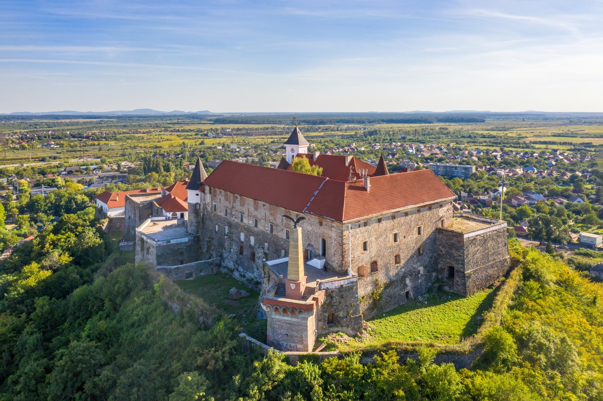
[edit]- Palanok Castle, 14th century. The castle of Munkács played an important role during the anti-Habsburg revolts in this territory and present-day Slovakia (1604–1711), especially at the beginning of the anti-Habsburg Revolt of Imre Thököly (1685–1688), as well as at the beginning of the revolt of Ferenc II. Rákóczi (early 18th century). This important fortress became a prison from the end of the 18th century and was used until 1897. The Greek national hero Alexander Ypsilanti was imprisoned in Munkács castle from 1821 to 1823.
- Saint Nicholas Monastery
- Wooden church built in the Ukrainian architectural style, 18th century
Sport
[edit]The main soccer team is MFA Mukachevo, which play in Ukrainian Second League.
Notable people
[edit]- Lojza Baránek
- Samuel Gottesman
- Ihor Kharatin
- Fyodor Koriatovych
- Lolita Milyavskaya
- Ivan Mozer
- Rio Preisner
- Baruch Yehoshua Yerachmiel Rabinowicz
- Moshe Leib Rabinovich
- Ludvík Ráža
- Chaim Elazar Spira
- Tzvi Elimelech Spira of Dinov
- Ján Strausz
- Svyatoslav Vakarchuk
- Yitzchok Yaakov Weiss
- Joseph Meir Weiss
- Yuri Yukechev
- Naomi Blake
- Ilona Zrinyi
Twin towns – sister cities
[edit]Mukachevo is twinned with:[17]
 Celldömölk, Hungary
- Dabas, Hungary
- Eger, Hungary
 Humenné, Slovakia
- Kisvárda, Hungary
- Mátészalka, Hungary
- Nyírmeggyes, Hungary
 Mielec, Poland
 Pag, Croatia
 Pelhřimov, Czech Republic
- Prešov, Slovakia
 Senta, Serbia
- Várkerület (Budapest), Hungary
Gallery
[edit]-
 Dormition Cathedral
 -
 A historical building on Yaroslava Mudroho Street
 -
 Mukachevo drama theater
 -
 Palace of Culture and Arts (Old Trade Academy Munkacs)
 -
 A street in the old town (Ilona Zrínyi Street)
 -
 Andriy Kuzmenko Park in Mukachevo
 -
 Aerial view of Palanok Castle
 -
 Northern outskirts of Mukachevo, Halish and Lovachka mountains
 -
 A church in Mukachevo
 -
 Central square of Mukachevo
 -
 Roman Catholic cathedral
 -
 Orthodox Church of Pochaiv Icon of Virgin Mary


See also
[edit]References
[edit]- ^ "In Ukraine, local elections legitimise a new political system - and the old faces behind it". www.opendemocracy.net. openDemocracy. 13 November 2020. Retrieved 7 June 2021.
- ^ "Andriy Baloha wins Mukachevo mayoral election at first round". Interfax Ukraine.
- ^ Чисельність наявного населення України на 1 січня 2022 [Number of Present Population of Ukraine, as of January 1, 2022] (PDF) (in Ukrainian and English). Kyiv: State Statistics Service of Ukraine. Archived (PDF) from the original on 4 July 2022.
- ^ a b Ukraine Census Archived 2009-04-30 at the Wayback Machine
- ^ a b Halai, O.,Ivanovchyk, I., Lengyel, I., Mohylevets, K., Turianytsia, T. (2020). Mukachevo (Мукачево). Encyclopedia of Modern Ukraine. ISBN 9789660220744. Retrieved 25 November 2020.
{{cite book}}: CS1 maint: multiple names: authors list (link) - ^ Council renamed Mukacheve into Mukachevo, BBC Ukrainian (23 May 2017)
- ^ a b c Mukachiv in the Encyclopedia of Ukraine
- ^ Kamenets-Podolski in Yad Vashem
- ^ "Climate: Mukachevo". Climate-Data.org. Retrieved 18 April 2014.
- ^ "1910. ÉVI NÉPSZÁMLÁLÁS 1. A népesség főbb adatai községek és népesebb puszták, telepek szerint (1912) | Könyvtár | Hungaricana".
- ^ "Всеукраїнський перепис населення 2001 | English version | Results | General results of the census | National composition of population | Zakarpattia region". Ukrcensus.gov.ua. Archived from the original on 2007-09-11. Retrieved 2009-07-08.
- ^ "Скільки дітей в Україні навчаються мовами національних меншин?".
- ^ Reconstruction of the OHL 400 kV Mukachevo-Kapusany section from SS 400 kV Mukachevo to the state border in Zakarpattia region
- ^ Andrew E. Kramer (May 9, 2016). "Ukraine Makes Iffy Progress After Trade Pact With Europe". The New York Times. Retrieved May 10, 2016.
- ^ a b c d e f One or more of the preceding sentences incorporates text from the United States Holocaust Memorial Museum, and has been released under the GFDL: "Jewish Community of Munkacs: An Overview". United States Holocaust Memorial Museum. Retrieved 2009-07-08.
- ^ Quoted in Sole, "Subcarpathian Ruthenia, 1918-1938," in The Jews of Czechoslovakia, vol. 1, p. 132.
- ^ "Munkács megyei jogú város településfejlesztési stratégiája" (PDF). mukachevo-rada.gov.ua (in Hungarian). Mukachevo. 2019. p. 2. Retrieved 2020-03-31.
Further reading
[edit]- Jelinek A. Yeshayahu, The Carpathian Diaspora : The Jews of Sub-Carpathian Rus' and Mukachevo, 1848-1948, New-York, Columbia University Press -East European Monographs, 2007, 412p.
- Pekar, Athanasius B. (1979). The Bishops of the Eparchy of Mukachevo, with Historical Outlines. Pittsburgh: Byzantine Seminary Pres.
- Véghseő, Tamás (2015). "Reflections on the Background to the Union of Uzhhorod / Ungvár (1646)" (PDF). Eastern Theological Journal. 1 (1): 147–181.
- The History of Cities and Villages of the Ukrainian SSR of the National Academy of Sciences of Ukraine
External links
[edit] Mukacheve travel guide from Wikivoyage
 Media related to Mukachevo at Wikimedia Commons
- Chisholm, Hugh, ed. (1911). . Encyclopædia Britannica (11th ed.). Cambridge University Press.
- Herbermann, Charles, ed. (1913). . Catholic Encyclopedia. New York: Robert Appleton Company.
- Mukachevo City Council - Mukachevo City Council website
- mukachevo.net – Mukachevo city portal
- Newspaper "Mukachivsjka Ratusha" Official news Mukachevo Mayor
- Mukachevo News, Panorama Mukachevo - http://panorama-mukachevo.com
- Mukachevo, Ukraine (Munkács, HU) ShtetLink on JewishGen.org
- The Palanok Castle - Pictures of the Palanok castle and view on Mukachevo from Sergey Sorokin - a private mountain guide
- Mukachiv in the Encyclopedia of Ukraine
- United States Holocaust Memorial Museum Jewish Community of Munkacs
- A Jewish Community in the Carpathian Mountains- The Story of Munkács - Yad Vashem
- A Film of Jewish Life in Munkacs Archived 2012-02-04 at the Wayback Machine
- security agency "schit"
- Mukachevo Survey City tour
- Mukacheve - ShtetLink
- Mukacheve Mukachevo, historical information, archival and contemporary photos, landmarks (in English)
Mukachevo
View on GrokipediaMukachevo (Ukrainian: Мукачево) is a city in Zakarpattia Oblast of western Ukraine, located in the valley of the Latorica River at approximately 48°26′N 22°43′E, serving as the administrative center of Mukachevo Raion.[1][2]
With a population of about 85,500 as of 2021, the city features a diverse economy centered on manufacturing, including electronics and furniture production, as well as agriculture and food processing.[1]
Historically first mentioned in the 12th century as a military fortification captured by Hungarians in the 10th century, Mukachevo expanded under the Kingdom of Hungary, enduring events like the Mongol invasion of 1241 and granting of Magdeburg rights in 1445, before shifting to Habsburg, Czechoslovak, and Soviet control, and finally integrating into independent Ukraine in 1991.[1][3]
The city is defined by landmarks such as the Palanok Castle, a 14th- to 18th-century fortress that functioned as a strategic stronghold and political prison, underscoring its longstanding role in regional defense and governance.[1][4]
Names and Etymology
Historical and Linguistic Origins
The name Mukachevo originates from the Slavic linguistic root muka (or mъka in proto-Slavic), which carries dual meanings of "torment" or "flour" depending on contextual interpretations in East Slavic languages.[5] [6] One prevailing theory attributes the "torment" sense to the hardships faced by laborers during the construction of the Palanok Castle in the 14th century, a fortress that dominates the city's skyline and symbolizes early medieval fortification efforts amid regional conflicts.[5] This etymology aligns with legends of a despotic local ruler whose oppression gave rise to the toponym, reflecting the Slavic-speaking inhabitants' pre-Hungarian presence in the Carpathian Basin by the 9th century.[5] An alternative linguistic hypothesis connects muka to "flour" or "meal," evoking the area's ancient grain processing and trade along the Latorica River, where water mills would have been central to early economies.[7] This interpretation draws from broader Slavic onomastic patterns linking place names to agrarian activities, though it lacks direct archaeological corroboration specific to Mukachevo.[8] The Hungarian exonym Munkács, first adapted during the Magyar conquest, likely phonetically evolved from the Slavic form, with possible reinforcement from Hungarian munkás ("worker"), highlighting cross-linguistic borrowing in a multiethnic borderland.[9] [10] Historically, the settlement's name emerges in records tied to the Hungarian tribes' migration through the Carpathians between 896 and 903 AD, documented as Muncas in chronicles describing Árpád's campaigns against Slavic strongholds.[1] This marks the earliest verifiable reference, predating formalized Hungarian administration and underscoring the site's role as a Slavic outpost before its integration into the Kingdom of Hungary by the 11th century.[1] Subsequent variants in Latin and German sources, such as Munkats or Munchacz, preserved the core phonetic structure, evidencing continuity amid shifting polities.[11]Variants in Different Languages
The name of the city reflects its position in a region with diverse linguistic influences, including Slavic, Hungarian, and Germanic traditions, due to centuries of rule under different empires. In Ukrainian, the official name is Мукачево, romanized as Mukachevo, though historical Ukrainian orthography sometimes rendered it as Мукачеве (Mukacheve) or Мукачів (Mukachiv).[5][11] In Hungarian, it has long been known as Munkács, a form used during periods of Hungarian administration from the medieval era through the early 20th century.[12][3] The Russian variant is Мукачево (Mukachevo), consistent with Cyrillic usage in Soviet times.[9] Other linguistic forms include Slovak and Czech: Mukačevo, reflecting Central European influences during the interwar Czechoslovak period; Polish: Mukaczewo; German: Munkatsch; Yiddish: מונקאטש (Munkatsh or Minkatch), prominent in the city's significant pre-World War II Jewish community; Romanian: Muncaci or Munceag; and Rusyn: Мукачово (Mukachovo).[9][11][12] These variants often stem from phonetic adaptations of the root possibly linked to Slavic terms for "torment" or Hungarian words for "labor," though etymological consensus remains debated among linguists.[5][9] Post-1991 Ukrainian independence standardized Мукачево for official use, emphasizing national linguistic norms over historical Hungarian dominance.[11]Geography
Location and Topography
Mukachevo is situated in Zakarpattia Oblast, southwestern Ukraine, at geographic coordinates approximately 48°26′N 22°43′E.[2][13] The city lies in the valley of the Latorica River, which flows through the region and contributes to its hydrological features.[2] Its position places it roughly 40–50 km from the borders with Hungary and Slovakia, and 90–100 km from the borders with Romania and Poland.[1] The topography of Mukachevo consists primarily of a relatively flat river valley terrain, with an average elevation of about 138 meters above sea level.[14] Surrounding the urban area are the foothills of the Carpathian Mountains, which rise to higher elevations and create a transitional landscape between the lowlands and the mountainous interior of the oblast.[14] This setting positions the city at the southern approach to key passes through the Carpathians, influencing its historical role as a strategic point.[1] The Latorica River and associated tributaries shape the local relief, with gentle slopes and alluvial plains dominating the immediate vicinity.[2]Climate and Environment
Mukachevo has a humid continental climate with cold winters and warm summers, featuring significant seasonal temperature variations. Average temperatures range from a January mean of -2.8°C to a July mean of 19.4°C, with annual averages around 10°C.[15][16] The lowest temperatures occasionally drop below -14°C, while summer highs can exceed 30°C.[13] Precipitation is moderately high, totaling approximately 1,037 mm annually, distributed relatively evenly but peaking in June with up to 120 mm monthly. The warm season, defined by average daily highs above 19°C, spans from late May to mid-September.[13] Snowfall occurs from December to March, contributing to winter precipitation totals of 40-50 mm per month.[15] The city's environment is shaped by its position in the Latorica River valley amid the Carpathian foothills, which provide a backdrop of mixed deciduous and coniferous forests covering much of Zakarpattia Oblast. The Latorica and Latoritsa rivers, tributaries of the Tisza, flow through Mukachevo, supporting local biodiversity but also posing flood risks during heavy rains.[17] Surrounding areas feature agricultural plains and forested hills, with the Palanok Castle hill exemplifying the varied topography that influences microclimates. Environmental challenges include ongoing pollution of the Tisza River basin, where poor waste management in Transcarpathia has led to increased contamination, particularly plastics and untreated sewage, worsened by disruptions from the Russia-Ukraine war since 2022.[18] Regional ecological issues encompass soil erosion, catastrophic flooding events, and forestry violations, such as unauthorized logging documented in Mukachevo forestry operations as of 2023.[19][17] Despite these pressures, the Carpathian ecosystems maintain significant carbon sequestration potential through extensive forests, though recovery from war-related damage may span decades.[20][21]
History
Medieval Foundations and Early Development
Archaeological evidence reveals continuous human settlement in the Mukachevo vicinity from the Neolithic Period through the Bronze and Iron Ages, extending into Slavic settlements of the 6th–9th centuries AD.[22][1] These early sites indicate the area's role as a natural crossroads for trade and migration in the Carpathian region, with fortifications likely established by East Slavic White Croats around 870–880 as military outposts.[1] The first historical references to the settlement, known as Muncas, appear in the Gesta Hungarorum (late 12th century), describing its capture by Hungarian forces during their conquest of the Carpathian Basin between 896 and 903.[1] By the 10th century, the territory briefly fell under Kyivan Rus' influence before transitioning to Hungarian control in the 11th century, where it served as a frontier stronghold.[22] A fortress on Castle Hill existed by this period, initially as wooden structures that withstood early assaults, including a Cuman raid in 1086 documented in Hungarian chronicles.[22][23] In response, King Ladislaus I ordered the construction of stone walls around 1086, marking the site's evolution into a more permanent defensive center.[1] The Mongol invasion of 1241 devastated the fortress, yet it was subsequently reinforced, reflecting Mukachevo's strategic importance amid regional turmoil.[22][1] By the late 13th century, following brief Galician-Volhynian princely oversight (1281–1301), the area was firmly reintegrated into the Kingdom of Hungary in 1321, laying groundwork for further development as a trading and manufacturing hub.[1] Early fortifications, including palisades and moats added around 1339, underscored the site's defensive priorities during this formative medieval phase.[1][23]Hungarian and Habsburg Eras
Munkács, as part of Bereg County in the Kingdom of Hungary, remained under Hungarian administration following the Habsburg acquisition of the Hungarian crown after the Battle of Mohács in 1526, though direct Habsburg influence intensified after the Ottoman-Habsburg wars concluded in the late 17th century.[24] The Palanok Castle served as a strategic fortress during this period, notably defended by Ilona Zrínyi, wife of the anti-Habsburg leader Imre Thököly, against imperial forces from 1685 until its surrender in January 1688.[25] This event marked the full integration of the region into Habsburg-controlled Royal Hungary, with the castle subsequently rebuilt and repurposed as a political prison for dynastic opponents.[26] In the early 18th century, Munkács emerged as a key center in Ferenc II Rákóczi's War of Independence (1703–1711), an uprising against Habsburg absolutism that began with kuruc rebels in the town inviting Rákóczi to lead the effort; the castle functioned as a primary stronghold during the conflict.[27] [28] Following the war's suppression by the Peace of Szatmar in 1711, Habsburg authorities reinforced control over the area, using the castle to incarcerate rebels and other dissidents.[26] During the Napoleonic era, from December 1805 to March 1806, Hungary's Holy Crown was hidden within the castle walls to safeguard it from French invasion threats.[29] Under the Dual Monarchy established by the 1867 Austro-Hungarian Compromise, Munkács experienced economic and urban development as a county seat in the Kingdom of Hungary, with improvements in trade, craftsmanship, and infrastructure reflecting broader modernization efforts.[30] The castle continued as a prison until 1897, when the Austro-Hungarian Ministry of Justice acquired it, though maintenance remained limited thereafter.[31] By the late 19th century, the town had evolved into a mid-sized regional hub, bolstered by its position in swampy but fertile lowlands suited to agriculture and local commerce.[32]Interwar Period and World War II
Following the dissolution of the Austro-Hungarian Empire after World War I, Mukachevo (known as Munkács in Hungarian and Mukacevo in Czech) was incorporated into the newly formed Czechoslovakia on June 4, 1920, via the Treaty of Trianon, becoming part of the province of Subcarpathian Rus'.[12] During the interwar period (1920–1938), the city served as an administrative and economic hub in the underdeveloped region, with a diverse population including a significant Rusyn (Ruthenian) majority and a large Jewish community comprising approximately 43–50% of residents, or around 11,000 individuals by 1930.[12] [33] Jews engaged in commerce, crafts, and politics, supporting Zionist organizations and establishing institutions like a Hebrew-speaking primary school in 1920 and a gymnasium in 1925; however, economic challenges persisted, with many in poverty and manual labor.[12] In the late 1930s, amid rising regional tensions and the Munich Agreement of September 1938, Czechoslovakia granted limited autonomy to Subcarpathian Rus' on October 11, 1938. The First Vienna Award on November 2, 1938, prompted Hungary to annex southern territories, including Mukachevo, disrupting local administration and leading to the flight or conscription of many young Jewish men into Hungarian forced labor units.[33] The remaining northern areas briefly formed the short-lived Republic of Carpatho-Ukraine on March 15, 1939, following Czechoslovakia's dismemberment, but Hungarian forces invaded and fully annexed the region the same day, restoring Hungarian control over Mukachevo until 1944.[12] Under Hungarian administration from 1938 to 1944, antisemitic policies intensified, including discriminatory laws and economic restrictions targeting Jews, who faced growing hostility despite initial optimism about Hungarian rule.[34] The German occupation of Hungary on March 19, 1944, accelerated persecution: Jews in Mukachevo were confined to Ghetto Munkács (also known as Ghetto Mukachevo), one of the first ghettos established by Nazi Germany in Hungary along with several others in Transcarpathia; two ghettos were established in the area, one for the city and one for the surrounding region, in April 1944, followed by mass deportations to Auschwitz-Birkenau starting in late May, with the final train carrying 3,080 individuals departing on May 23, 1944; over 90% of the pre-war Jewish population perished.[33] Soviet forces of the 4th Ukrainian Front liberated Mukachevo in late October 1944 during the East Carpathian Offensive (September 8–October 28, 1944), ending Axis control and facilitating the region's annexation to the Soviet Union post-war.[35]Soviet Annexation and Post-War Changes
Following the Red Army's occupation of Transcarpathia in late 1944, the Soviet Union pressured Czechoslovakia into ceding the region, including Mukachevo, through a treaty signed on June 29, 1945, by President Edvard Beneš amid influence from Czech and Slovak communists and Soviet authorities.[36] The annexation was formalized in 1946, integrating the territory as Zakarpattia Oblast within the Ukrainian Soviet Socialist Republic, with Mukachevo designated as a key administrative and transport hub due to its railway connections.[37] This transfer disregarded local ethnic compositions and prior Czechoslovak sovereignty, prioritizing Soviet geopolitical expansion over plebiscites or self-determination.[38] Immediate post-war policies focused on demographic reconfiguration and security measures, including the internment and deportation of ethnic Hungarians, who comprised a significant minority in Mukachevo and surrounding areas. Between 1944 and 1946, Soviet forces and local collaborators deported an estimated 20,000 to 30,000 Hungarians from Transcarpathia to labor camps or for forced relocation, targeting perceived collaborators and reducing Hungarian influence to consolidate Ukrainian and Russian dominance.[39] [40] Jewish survivors, numbering fewer than 10% of pre-war levels after Holocaust deportations, faced further emigration restrictions or assimilation pressures, with many fleeing secretly to Czechoslovakia or Palestine.[11] These actions facilitated the influx of ethnic Ukrainians from eastern regions, altering Mukachevo's population from a multiethnic mix (pre-war estimates: ~48% Jewish, 22% Hungarian, 24% Rusyn/Ukrainian in 1921) toward Ukrainian majorities by the 1950s.[41] Over the subsequent decades, Soviet administration imposed collectivization of agriculture, nationalization of industries, and suppression of religious institutions, transforming Mukachevo into an industrial node with factories for machinery, food processing, and brewing.[42] Population growth accelerated through migration and urbanization, reaching approximately 50,500 by 1966 from wartime lows, driven by state-directed development but accompanied by Russification policies that marginalized Hungarian and Rusyn languages in education and media.[41] Cultural sites, including churches and synagogues, were repurposed or closed under atheist campaigns, while infrastructure like the Palanok Castle served military purposes before becoming a museum in the 1950s. These changes entrenched centralized control, stifling local autonomy until Ukrainian independence in 1991.[43]Ukrainian Independence and Contemporary Events
Following Ukraine's declaration of independence from the Soviet Union on August 24, 1991, Mukachevo was incorporated into the newly sovereign state as a city of oblast significance within Zakarpattia Oblast, retaining its role as a regional transport and administrative hub.[1] The transition involved the privatization of Soviet-era industries and a shift toward market-oriented development, with the city's economy increasingly oriented toward tourism centered on Palanok Castle and local winemaking, though unemployment remained elevated in the 1990s amid broader post-Soviet economic contraction.[44] In July 2015, a violent clash in Mukachevo between members of the Right Sector nationalist group and local law enforcement—triggered by disputes over an illegal logging operation allegedly protected by Security Service of Ukraine (SBU) officials—resulted in eight deaths, including civilians, and exposed entrenched corruption and weak central control over regional armed formations.[45] The incident, which involved a firefight near the city outskirts, prompted the dismissal of the regional SBU head and highlighted tensions between volunteer battalions formed during the 2014 Donbas conflict and state institutions.[45] The escalation of the Russo-Ukrainian War after Russia's full-scale invasion on February 24, 2022, transformed Mukachevo into a refuge for internally displaced persons (IDPs) from eastern and southern Ukraine, with the city hosting thousands amid its relative geographic isolation from frontlines.[46] Local infrastructure, including railways and border facilities, supported humanitarian aid flows, while the absence of frequent air raid sirens in Zakarpattia contributed to its perception as one of Ukraine's more stable rear areas.[47] On the night of August 20-21, 2025, Russian missile strikes targeted industrial sites in Mukachevo, injuring 15 people, igniting fires at a facility reportedly linked to Western production, and signaling an expansion of aerial campaigns into western Ukraine beyond energy infrastructure.[48] [49] Videos from the scene showed thick smoke rising from the affected plant near the Hungarian border, with no immediate claims of responsibility but consistent with patterns of strikes on logistics and manufacturing nodes.[50]Demographics
Population Trends Over Time
The population of Mukachevo grew steadily from the late 19th century through the early 20th century, reflecting economic expansion, trade, and administrative importance under Austro-Hungarian governance. Census records indicate 9,644 residents in 1880, rising to 10,581 by 1890, 13,640 in 1900, and 16,518 in 1910.[51] This expansion continued into the interwar period under Czechoslovak administration, reaching approximately 26,000 by 1930, supported by regional commerce and infrastructure development.[3] Post-World War II Soviet industrialization and urbanization drove further rapid growth, with the population expanding to around 50,500 by 1966 and peaking at 91,000 according to the 1989 Soviet census.[52] Following Ukrainian independence, demographic pressures including economic transition, out-migration, and lower birth rates led to a decline, with the 2001 census recording 82,200 inhabitants.[1] Subsequent stabilization occurred amid regional recovery, with official estimates at 85,796 as of January 1, 2020.| Year | Population |
|---|---|
| 1880 | 9,644[51] |
| 1910 | 16,518[51] |
| 1930 | ~26,000[3] |
| 1989 | 91,000 |
| 2001 | 82,200[1] |
| 2020 | 85,796 |
Ethnic Composition and Diversity
According to the 2001 Ukrainian census, Mukachevo's population of approximately 82,300 was predominantly ethnic Ukrainian, constituting 77.1%. Russians formed the next largest group at 9.0%, followed by Hungarians at 8.5%. Germans accounted for 1.9%, Roma for 1.4%, and smaller percentages included Romanians (0.6%), Poles (0.3%), and others such as Belarusians, Jews, and Armenians, each under 0.5%.[54][55]| Ethnic Group | Percentage (2001 Census) |
|---|---|
| Ukrainians | 77.1% |
| Russians | 9.0% |
| Hungarians | 8.5% |
| Germans | 1.9% |
| Roma | 1.4% |
| Others | 2.1% |