

Community hub
0 subscribers8 pages, 0 posts
Recent from talks
All channels
Be the first to start a discussion here.
Be the first to start a discussion here.
Be the first to start a discussion here.
Be the first to start a discussion here.
Contribute something
Welcome to the community hub built to collect knowledge and have discussions related to Nelliampathi.
Nothing was collected or created yet.
Nelliampathi
View on Wikipediafrom Wikipedia
Nelliyampathy (also spelled as Nelliampathi) is a hill station, located 60 kilometres (37 mi) from Palakkad, state of Kerala, India.
Key Information


Geography
[edit]- Nelliampathy is surrounded by tea and coffee plantations.
- The village has its own gram panchayat and forms a part of the Chittur taluk. Pothundi Dam, which was constructed in the 19th century, is the entrance to Nelliyampathy.
Seetharkundu
[edit]A viewpoint called Seethargund is situated 8 km away from Nelliyampathy. Seethargund, according to beliefs is the place where Lord Rama, Laxmana and Seetha rested during their exile.
Kesavan Rock
[edit]Another attraction of Nelliyampathy is the Kesavanpara viewpoint. The film Mrigaya, starring Mammootty, was shot here.[2][3]
Demographics
[edit]As of 2001[update] India census, Nelliyampathy had a population of 8,718 with 4,358 males and 4360 females.[4]
Gallery
[edit]-
 Sitharkundu viewpoint
 -
 A mountain stream
 -
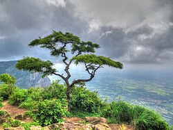
 Hill view
 -

-
 Another view of Sitharkundu viewpoint
 -


.jpg)


See also
[edit]References
[edit]- ^ "Basic details of Grama Panchayats in Palakkad District". lsgkerala.gov.in.
- ^ Maradei, Irene (2007). "Nelliyampathy". Things to Do and See Around Palakkad. Palakkad. Archived from the original on 7 October 2010. Retrieved 25 January 2010.
- ^ "Reports of National Panchayat Directory". Ministry of Panchayati Raj. Archived from the original on 30 December 2013. Retrieved 29 December 2013.
- ^ "Census of India : Villages with population 5000 & above". Registrar General & Census Commissioner, India. Retrieved 29 December 2013.
External links
[edit]Wikimedia Commons has media related to Nelliampathi.
- Silent Valley model eco-tourism proposed to save Nelliampathy Hills
 Nelliampathy travel guide from Wikivoyage
| Organisations | |
|---|---|
| Informative articles | |
| Airports | |
| Amusement parks | |
| Archaeological sites |
|
| Beaches |
|
| Boat races | |
| Caves | |
| Dams |
|
| Festivals |
|
| Forts | |
| Islands | |
| Lakes | |
| Lighthouses | |
| Mountains |
|
| Museums |
|
| Palaces |
|
| Ancient residences | |
| Waterfalls |
|
| Wildlife sanctuaries |
|
| Zoos | |
Nelliampathi
View on Grokipediafrom Grokipedia
Geography and Environment
Location and Topography
Nelliampathi is situated in the Palakkad district of Kerala, India, approximately 60-65 km northeast of Palakkad town, at coordinates 10.535393°N 76.693607°E.[3] The region encompasses an area of approximately 200 km² (20,005 hectares) as the Nelliyampathy Forest Division within Chittur taluk and falls under the administrative jurisdiction of the Nelliyampathy Forest Division, part of the larger Nemmara Forest Division managed by the Kerala Forest Department.[4][5] The broader Key Biodiversity Area covers 286 km².[4] Elevations in Nelliampathi range from 467 meters to 1,572 meters above sea level, with the highest peak, Nellikotta or Padagiri, reaching 1,585 meters.[3][6] This varied altitude contributes to its status as a prominent hill station in the southern Western Ghats. The topography of Nelliampathi consists of undulating plateaus, deep valleys, and densely forested ridges, characteristic of the Western Ghats' erosional landforms.[7] Geologically, it forms part of the ancient Gondwanan uplift that shaped the Western Ghats, featuring metamorphic rocks and a chain of ridges separated by river-cut valleys, aligning with the broader Nilgiri-Anamalai hill complex.[4] Access to the hill station from the surrounding plains is via a winding road from Nenmara, featuring a series of nine to ten hairpin bends—locally referred to as the "Ooty Road"—that ascend steeply through the terrain, providing panoramic views of the ascending landscape.[8][6] Nelliampathi lies adjacent to the Kerala-Tamil Nadu border, sharing ecological continuity with forested areas in Coimbatore district.[4] Key villages within its boundaries include Kaikatty, serving as the primary entry point from the foothills, and Pothundi, located near the base of the ascent.[9] The nearby Pothundi Dam, an earthen structure across the Meenichiladipuzha and Padipuzha rivers, acts as a significant hydrological feature that shapes the local landscape through its reservoir, irrigating downstream areas and enhancing the scenic valley views en route to the hills.[10][3]Climate
Nelliampathi exhibits a tropical monsoon climate, classified under the Köppen system as Am, characterized by high temperatures throughout the year with a distinct wet season. The average annual temperature ranges from 15°C to 30°C, with a mean of approximately 22°C. During the summer months from February to May, daytime highs often reach 25–30°C, while winter periods from December to January see lows dipping to 15°C, providing a cooler respite compared to the surrounding lowlands.[11] Rainfall in Nelliampathi is abundant, with an annual average of 3,500–4,000 mm, predominantly influenced by the southwest monsoon. The monsoon season spans June to September, during which precipitation peaks, including up to 2,067 mm in July alone, contributing to lush vegetation and water replenishment. In contrast, the dry season from December to March experiences minimal rainfall, typically under 50 mm per month, allowing for clearer skies and moderate humidity.[12][11] The hill station's elevation creates unique microclimate effects, including frequent mist and fog, especially during early mornings and evenings, which enhance its scenic appeal and moderate daytime warmth. This cooler, humid environment supports local agriculture, such as orange cultivation, which thrives in the temperate conditions of the winter months when temperatures remain consistently below 25°C.[13][14] Heavy monsoon rains pose environmental challenges, frequently triggering landslides along the steep hairpin bends of access roads, as seen in multiple incidents that have disrupted connectivity and required extensive repairs. Additionally, the substantial precipitation plays a vital role in sustaining forest humidity, preventing desiccation and supporting the overall ecological balance in the surrounding highlands.[15][16]Flora and Fauna
Nelliampathy's ecosystems are characterized by tropical evergreen and semi-evergreen rainforests, which dominate the landscape and support high biodiversity typical of the southern Western Ghats.[4] These forests include old-growth wet evergreen patches interspersed with shola-grassland mosaics, where stunted evergreen trees blend with montane grasslands at higher elevations.[4] Approximately 50% of the 20,005-hectare Nelliyampathy (Nemmara Division) area is covered by natural forest habitats, with the remainder influenced by human-modified landscapes.[4] The flora of Nelliampathy is diverse, with old-growth wet evergreen forests hosting 152 plant species across 51 families, including 34% endemic to the Western Ghats.[17] Dominant trees include Cullenia exarillata, Palaquium ellipticum, Mesua thwaitesii, and Myristica beddomei, which form the canopy and contribute to a basal area of 53.6–102.1 m²/ha.[17] Understorey vegetation features climbers and shrubs, with notable endemics such as Glycosmis nelliyampathiensis (Rutaceae) and recently discovered species like Ischaemum sunilii (Poaceae) and Stellaria mcclintockiae (Caryophyllaceae).[18][19][20] Medicinal plants, including those from families like Cucurbitaceae and Acanthaceae, are also prevalent, with ethnomedicinal surveys documenting 151 species used by local healers.[21] Fauna in Nelliampathy includes several endangered and endemic species reliant on the forested habitats. The lion-tailed macaque (Macaca silenus), an endangered primate endemic to the Western Ghats, maintains a population of approximately 200 individuals across 13 troops in the area.[22] Other mammals encompass the Indian elephant (Elephas maximus), tiger (Panthera tigris), Nilgiri langur (Semnopithecus johnii), Nilgiri tahr (Nilgiritragus hylocrius), gaur (Bos gaurus), sambar (Rusa unicolor), and giant squirrel (Ratufa indica).[4] Avian diversity features 109 species, with 12 Western Ghats endemics; notable threatened birds include the vulnerable Malabar grey hornbill (Lophoceros fasciatus), near-threatened Nilgiri pipit (Anthus nilghiriensis), and vulnerable broad-tailed grassbird (Schoenicola platyurus).[23] Reptiles such as the king cobra (Ophiophagus hannah) inhabit the dense undergrowth, while recent roadkill surveys along key routes documented 330 individuals from at least 72 vertebrate species, highlighting the presence of diverse terrestrial and avian fauna and underscoring the urgent need for wildlife corridors and traffic mitigation measures as of 2025.[24] Conservation efforts in Nelliampathy are critical due to its inclusion in the UNESCO World Heritage-listed Western Ghats, recognized for exceptional biodiversity.[1] The Nelliyampathy Reserve Forest serves as a Key Biodiversity Area (KBA) but lacks full protected status, with only 0% direct coverage by notified reserves, though it adjoins Parambikulam Wildlife Sanctuary.[4] Major threats include habitat fragmentation from agriculture and leased plantations (3,956 ha), road infrastructure causing roadkill, construction, and human-wildlife conflicts like wildlife feeding that endanger species such as the lion-tailed macaque.[4][25] Proposed strategies involve expanding protection by incorporating the area into Parambikulam Sanctuary and restoring fragmented habitats to mitigate these pressures.[23]History
Ancient and Mythological Associations
Nelliampathy holds mythological significance rooted in the Ramayana, where local legends describe it as a resting place for Lord Rama, his wife Sita, and brother Lakshmana during their exile in the forest. This association is particularly linked to Seetharkundu, a viewpoint and waterfall site whose name derives from "Seetha Arund," meaning Sita's rest, symbolizing the spot where Sita is believed to have paused and bathed.[26][27] The region has been inhabited by indigenous tribes such as the Malasar and Kadar since ancient times, with evidence of early human activity including rock shelters used as natural dwellings by these hunter-gatherer communities. Archaeological findings in the broader Palakkad district, including sites near Malampuzha and Nemmara, reveal megalithic structures and Iron Age tools, such as tuyeres used in early iron smelting, indicating prehistoric settlements dating back to the Iron Age around 1000 BCE. In March 2025, the Archaeological Survey of India discovered over 110 megalithic structures near the Malampuzha dam, further confirming Iron Age presence in the area, dating to approximately 1000–500 BCE.[28][29][30][31] Oral histories among these tribes recount migrations from the Tamil Nadu plains, driven by environmental and social factors, contributing to the cultural fabric of the hill ranges.[28][29][30] During the medieval period, Nelliampathy formed part of the Kollengode principality, ruled by the Vengunad Kovilakam, a small feudal estate in the Malabar region with ties to ancient Tamil and Kerala royal lineages. This governance facilitated the establishment of temples dedicated to local deities, such as the Nellikulangara Bhagavathi Temple near Nenmara, which exhibits Dravidian architectural influences through its granite construction and ritual spaces, reflecting the cultural synthesis of the era. Limited excavations in the area have uncovered artifacts supporting these historical connections, underscoring the principality's role in preserving indigenous and regional traditions.[13][32][33]Colonial and Modern Development
During the colonial era, the Nelliyampathy hills were originally under the control of the Vengunad Kovilakam of Kollengode, a local principality, which leased vast tracts of virgin forest land to British interests in the late 19th century. In 1889, significant portions were leased to British planters Arthur Hall and W.R.M. McKenzie, who initiated commercial cultivation of coffee and other crops, marking the beginning of organized plantation activities. By the 1890s, over 100 European planters had established estates in the region, drawn from coffee districts in Mysore, transforming the landscape into a hub for cash crop production that formed the backbone of the local estate economy. Colonial infrastructure included the construction of sturdy bungalows for planters, such as one built in 1897 amid coffee and cardamom plantations, and rudimentary roads to support transport, with bullock carts and head loads being common until better access developed. Following India's independence in 1947, Nelliyampathy, part of the Malabar district under the Madras Presidency, was integrated into the newly formed state of Kerala during the linguistic reorganization of states in 1956. The introduction of cash crops during the colonial period had already entrenched an estate-based economy, but post-independence land reforms under the Kerala Land Reforms Act of 1963, with major implementations in the 1970s, impacted plantation ownership by redistributing excess lands and granting tenancy rights, though large plantations received exemptions to preserve agricultural output. The Nelliyampathy Gram Panchayat was established in 1962, providing local governance and administrative oversight amid these changes. The scenic access road from Nemmara, approximately 30 km from Palakkad and completed in 1932 during the colonial period, spanned about 40 km in total from the plains and became a key infrastructure milestone, enabling easier connectivity. In modern times, conservation efforts have gained prominence, with the Kerala Forest Department proposing a Silent Valley-model eco-tourism project in 2010 to protect the ecologically fragile hills while promoting sustainable visitation. Forest conservation laws, including enhancements to biodiversity corridors in the Western Ghats during the 2000s, have supported habitat connectivity for species like elephants, integrating Nelliyampathy into broader regional protection frameworks. Infrastructure advancements post-2000 include the completion of rural electrification under Kerala's Total Electrification Scheme by 2017, ensuring full coverage, and ongoing road widening projects on the Nelliyampathy route, such as upgrades to the Nenmara-Nelliyampathy road initiated in the 2010s to improve safety and accessibility. As of 2025, tribal communities like the Malasar continue to face challenges, including denial of rights to pay land tax despite receiving titles in 2019, impacting their land ownership and livelihoods.[34]Economy
Agriculture and Plantations
Nelliampathy's agricultural landscape is dominated by plantation crops, including tea and coffee. These crops were introduced in the late 19th century, when tracts of the hills were leased in 1889 to British planters, building on earlier coffee and cardamom cultivation that began in the 1870s; orange cultivation was introduced in 1943.[35] In addition to tea and coffee, orange groves and cardamom plantations serve as key sources of fruit and spice exports, while rubber and other spices like pepper and vanilla contribute to diversified produce.[11] The fertile valleys and misty slopes provide ideal conditions for these crops, supporting a mix of commercial estates and smaller farms. The region hosts numerous estates, including large operations like those of the POABS group, which manage extensive tea, coffee, and spice plantations across the hills.[11] Harvesting in these estates is labor-intensive, relying on seasonal workers for plucking tea leaves, picking coffee cherries, and gathering oranges and cardamom pods, often by hand to maintain quality.[36] Orange production is notable, with government initiatives at the local farm enhancing yields through continuous cultivation techniques on dedicated acreage.[37] Estates such as Seethargundu integrate coffee with intercrops like pepper, oranges, and cardamom, spanning hundreds of acres to optimize land use.[38] Farmers in Nelliampathy employ terracing to control soil erosion on the steep slopes, a critical practice for sustaining productivity in this hilly terrain.[39] Organic farming has gained traction since the 2010s, with estates like POABS adopting sustainable methods to produce chemical-free tea, coffee, and spices, aligning with growing demand for eco-friendly produce.[40] Climate change poses significant challenges, including erratic monsoons that have led to reduced coffee yields through altered rainfall patterns and increased temperatures, exacerbating issues like berry shedding and lower overall output in recent years.[41][42] Agriculture and plantations form a cornerstone of Nelliampathy's local economy, driving trade in spices and fruits through markets in nearby Palakkad.[43] The sector benefits from government subsidies aimed at hill agriculture, supporting infrastructure and sustainable practices to bolster resilience.[44] Overall, these activities contribute substantially to employment and revenue in the area, complementing Kerala's broader agricultural economy.[45]Tourism Industry
Nelliampathy, often nicknamed the "Poor Man's Ooty" for its affordable access to scenic hill station experiences similar to those in Ooty, attracts a modest but growing number of visitors primarily for its eco-tourism offerings.[46] Pre-2020, annual domestic tourist visits hovered around 50,000 to 67,000, with 54,111 recorded in 2016 and 67,258 in 2017, while foreign arrivals remained low at just 317 in 2017.[47] The peak season spans November to May, aligning with the cooler, drier months that draw families and nature enthusiasts seeking respite from Kerala's lowland heat. Post-pandemic, visitor numbers have risen, with reports of a surge in 2023 driven by renewed domestic travel interest in lesser-known destinations. As of 2025, farm tourism has seen significant growth, attracting tens of thousands of visitors to historic sites like the government orange farm.[48][49] Tourism plays a vital role in the local economy, contributing significantly to income through homestays, local guides, and eateries that cater to budget-conscious travelers. In broader Kerala contexts, the sector accounts for about 10% of the state GDP and supports 1.5 million jobs, with hill stations like Nelliampathy benefiting from similar multiplier effects in rural areas via service-based employment.[50] The Kerala Tourism Department has promoted the area through eco-tourism initiatives, including funding for trekking trails and nature programs in the 2020s to enhance sustainable visitor experiences.[51] This support has integrated elements like plantation tours, briefly showcasing agricultural products such as tea and oranges alongside natural attractions. Accommodation infrastructure includes over 30 listed options ranging from resorts and farm stays to budget homestays and tented camps, with additional unlisted local setups providing diverse choices for around 200 rooms or units in total. Some viewpoints impose nominal entry fees to manage access, while sustainable practices, such as mandatory waste segregation and disposal guidelines introduced under Kerala's statewide rules in 2016, help mitigate environmental strain.[52][53][54] Despite growth, the industry faces challenges including weekend overcrowding that strains limited facilities like roads and viewpoints, as noted in 2023 reports of inadequate infrastructure despite rising footfall. The seasonal nature of tourism leads to employment fluctuations, with potential underutilization during the June-to-October monsoon period, though opportunities for agritourism extensions could address this by diversifying offerings year-round.[48]Demographics and Administration
Population and Composition
As per the 2011 Indian census, Nelliyampathy had a total population of 5,545, comprising 2,815 males and 2,730 females.[55] The population density was 9.63 inhabitants per square kilometer, reflecting the area's expansive 576.53 km² terrain dominated by hills and forests.[55] Between 2001 and 2011, the population declined from 8,718 to 5,545, marking a decadal growth rate of -36.4%, largely driven by out-migration to urban centers for employment opportunities.[56][55] The demographic composition features a notable indigenous element, with scheduled tribes accounting for 16.4% of the population (908 individuals), primarily from the Irular and Malasar communities inhabiting the forested hills.[55][57][34] Scheduled castes constitute 22.5% (1,248 individuals). The overall literacy rate stood at 74.2%, with 4,113 literates, including higher male literacy but a gender gap evident in female rates.[55] The sex ratio was 970 females per 1,000 males, slightly below the state average, while the population is entirely rural as a designated village.[55] Among the working population, 2,996 individuals (54% of the total) were engaged in economic activities, with 84% classified as main workers. Primary occupations center on agriculture, including cultivation and plantation labor, which engage a substantial portion of the workforce, supplemented by roles in the tourism sector amid the area's growing appeal as a hill station.[58] Socio-economic conditions include access to basic services, with several primary schools and community health clinics serving the residents, though challenges like out-migration persist.[59]Governance and Culture
Nelliyampathy is administered by the Nelliyampathy Gram Panchayat, a local self-government body under the Chittur taluk of Palakkad district in Kerala.[60] The panchayat comprises 13 wards, each represented by elected members from various political parties including the Indian National Congress, Revolutionary Socialist Party, Communist Party of India (Marxist), and Bharatiya Janata Party, as per the 2020 local body elections.[61] It oversees essential services such as water supply, sanitation, and road maintenance, ensuring basic infrastructure for the hill station's residents amid its plantation-dominated landscape.[62] The cultural life of Nelliyampathy reflects Kerala's broader traditions blended with indigenous tribal influences from communities like the Irular and Malasar, who inhabit the surrounding forests.[28][34] Festivals such as Onam, the harvest celebration in August-September, and Vishu, marking the Malayalam New Year in April, are observed with enthusiasm, featuring floral decorations, traditional feasts, and community gatherings that unite locals and tribal groups.[43] Tribal customs include folk performances akin to those of the Irular and Malasar, involving rhythmic dances accompanied by drums during seasonal rituals, preserving oral histories and nature reverence.[28] Local cuisine emphasizes hill-grown spices like cardamom and pepper, integrated into Kerala staples such as rice-based dishes and curries, with fresh oranges from nearby orchards adding a distinctive citrus tang to desserts and beverages.[1] Community dynamics in Nelliyampathy highlight women's self-help groups under the Kudumbashree program, where over 200 women have formed collectives to revive cardamom cultivation, accessing bank loans and promoting sustainable farming.[63] Locals also contribute to conservation through eco-development committees in the adjacent Parambikulam Tiger Reserve, including anti-poaching patrols that deter wildlife threats and protect biodiversity.[64] The primary language is Malayalam, with Tamil influences evident due to the region's proximity to Tamil Nadu and historical migrations.[65] Efforts for tribal upliftment have intensified in the 2020s through government schemes like the Secure Accommodation and Facility Enhancement (SAFE) initiative, which aims to construct 10,000 houses for Scheduled Tribes and enhance habitat security under the Forest Rights Act, 2006, granting community tenures to vulnerable groups in forested areas.[66] These programs focus on habitat rights, enabling tribes to manage resources sustainably while addressing displacement risks from development. However, as of 2025, challenges persist, with tribal families in Nelliyampathy facing issues in exercising land rights despite titles issued under the Forest Rights Act in 2018.[34][67]Attractions and Infrastructure
Key Tourist Sites
Seetharkundu, situated approximately 8 km from the main town of Nelliyampathy, is renowned for its 100-foot-high (about 30 meters) waterfall cascading into the valley below and a prominent viewpoint providing expansive vistas of the Palakkad plains and surrounding landscapes.[68] The site carries mythological importance, believed to be the resting place of Sita, Rama, and Lakshmana during their exile as described in the Ramayana.[26] Visitors often favor it for sunrise observations, where the first light illuminates the misty hills, and for short trekking paths that wind through nearby forests and tea plantations, offering moderate physical activity amid natural scenery.[1] Kesavanpara, also known as Kesavan Rock, lies about 5 km from Nelliyampathy and serves as a key vantage point with sweeping overlooks of the verdant valleys, tea estates, and distant waterfalls.[69] Access to the summit requires a roughly 1-km hike along a moderate trail, suitable for those seeking panoramic hill station perspectives without extensive effort.[70] Other notable attractions include the Pothundi Dam, located approximately 17 km from the town, a 19th-century earthen structure across the Meenichiladipuzha and Padipuzha rivers that supports irrigation and features a reservoir ideal for boating activities amid scenic surroundings. The expansive tea estates surrounding Nelliyampathy offer guided walks that highlight cultivation processes, harvesting techniques, and the lush plantation terrain.[1] Nearby orange farms, particularly the government-run orchard, allow seasonal fruit picking, with peak availability from February to April, enabling visitors to experience fresh produce directly from the groves. The government-run orchard has gained popularity for farm tourism, attracting tens of thousands of visitors in 2025 for seasonal picking and direct sales.[37] For safety, most sites operate between 6 AM and 6 PM, with entry to the hills generally restricted after 4 PM unless accommodations are pre-booked; permits are required for venturing onto designated forest trails to ensure environmental protection and visitor security.[71][72]Transportation and Access
Nelliampathy is primarily accessed by road, with the main route originating from Palakkad, approximately 60 km away, along the Nelliyampathy Road that ascends through a series of nine hairpin bends after passing the Pothundy Dam near Nenmara.[3][8] The journey from Thrissur covers about 80 km, typically via Palakkad or connecting highways.[73] The nearest airport is Coimbatore International Airport in Tamil Nadu, situated roughly 100 km away, offering connections to major Indian cities.[74] Public transportation options include Kerala State Road Transport Corporation (KSRTC) buses operating from Palakkad bus stand to Nelliampathy, with services departing at 4:30 a.m., 5:30 a.m., 7:00 a.m., 9:30 a.m., 12:30 p.m., 1:30 p.m., and 5:00 p.m. (as of 2025; check for updates), and the trip duration ranging from 2 to 3 hours depending on traffic and road conditions.[75][76] There is no railway station within Nelliampathy; the closest is Palakkad Junction, 60 km away, which serves as a major rail hub on the Southern Railway network.[74] Within the hill station, auto-rickshaws provide local mobility for short distances, though fares can be higher due to the terrain, often starting at ₹100 for brief rides.[77] The internal road network spans around 20 km of motorable paths, connecting key areas like Kaikatty Junction, plantations, and viewpoints, allowing access by private vehicles or taxis.[78] Off-road exploration is facilitated by several trekking paths, such as those leading to Seetharkundu and Palakapandi, offering trails through forests and estates for hikers.[1] However, the access road and internal routes are prone to seasonal disruptions during the monsoon (June to September), when heavy rains often cause landslides and temporary closures, as seen in incidents blocking sections near the hairpin bends.[79][80]References
- https://en.wikivoyage.org/wiki/Nelliampathy