Hubbry Logo
Pinetree LinePinetree LineMain
Open search
Pinetree Line
Community hub
Pinetree Line
logo
8 pages, 0 posts
0 subscribers
Be the first to start a discussion here.
Pinetree Line
Pinetree Line
from Wikipedia

Pinetree Line
Active1951–1991
CountryCanada
BranchRoyal Canadian Air Force
United States Air Force
TypeEarly-warning radar
RoleContinental Air Defense
Part ofNorth American Aerospace Defense Command

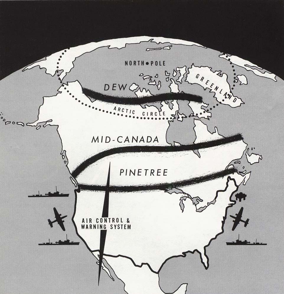
The Pinetree Line was a series of radar stations located across southern Canada at about the 50th parallel north, along with a number of other stations located on the Atlantic and Pacific coasts. Run by North American Aerospace Defense Command (NORAD) (after its creation), over half were staffed by United States Air Force personnel with the balance operated by the Royal Canadian Air Force. The line was the first coordinated system for early detection of a Soviet bomber attack on North America. Its radar technology quickly became outdated, and the line was in full operation only for a short time.

History

[edit]
Static display of an AN/FPS 508 radar antenna, one of the types used on the Pinetree Line. The antenna rotated at 5 revolutions per minute. The system could detect aircraft up to 200 mi (320 km) away and at altitudes of 100,000 ft (30,000 m). This antenna is on display at Air Force Heritage Museum and Air Park, Winnipeg

Plans for what would become the Pinetree Line were underway as early as 1946 within the Permanent Joint Board on Defense (PJBD), a Canadian-U.S. organization. However, the costs of running such a system in the post-war era was too high, and instead Canada concentrated on the areas around Ontario and Quebec, while the United States set up stations in the Midwest and along the eastern seaboard. With the successful test of an atomic bomb in the USSR, plans changed considerably. In 1949 Congress agreed to a $161 million construction program in co-operation with the RCAF, for a continuous line of stations across southern Canada. The USAF's Continental Air Command and the RCAF met in October 1950 to start planning, and in January 1951 the PJBD presented Recommendation 51/1 for the Extension of the Continental Radar Defence System. The USAF later requested an additional set of six (potentially) mobile stations to provide low-level coverage. Later, it was learned the original radar systems performed better than expected, hence a number of the mobile sites were never deployed.

The system was eventually deployed as a series of 33 main stations and 6 smaller "gap fillers". The majority of these ran in a line at about the 53rd parallel in the west (to offer coverage of major Canadian cities) and about the 50th parallel in the east. A second line ran up the eastern seaboard from the southern tip of Nova Scotia to the southern tip of Baffin Island. Of these, 22 of the main stations and all of the gap fillers were paid for by the USAF, leaving 11 to the RCAF. However 16 of the main stations were staffed by RCAF personnel. On 1 January 1955, the system was officially handed over to RCAF command, and over time an additional 10 stations were added. The stations on the east coast used the Pole Vault system for communication.

Saint Anthony Air Station, Newfoundland in July 1961. The main radar is centered, the Pole Vault antennas are on the right.

The Pinetree Line had several technical problems that limited its usefulness almost immediately. For one, the system used a simple pulse radar technique, which made it unable to detect targets close to the ground due to radar clutter as well as being trivially easy to jam using the recently introduced carcinotron tube. Another was that its location near population centres meant it offered only a last minute warning, and as the USSR moved to jet-powered bombers the warning time was reduced. Studies were already underway in 1951 to build a series of Doppler bistatic radar stations somewhat farther north, which would develop into the Mid-Canada Line. By 1957, just over a year after the Mid-Canada Line was operational, a more advanced long-range search radar, mainly in the Canadian north and Alaska were deployed comprising the Distant Early Warning Line.

The Pinetree stations were kept operational during this period, and most underwent modifications as a part of the deployment of the Semi-Automatic Ground Environment (SAGE). SAGE dramatically reduced the workload at the stations, cutting staff requirements by well over half. By the later 1950s some were being mothballed as newer systems came on line to the north. Nevertheless, many of the Pinetree stations were kept operational into the 1980s, particularly on the Atlantic and Pacific coasts.

Radar stations

[edit]

Initial sort is based on longitude from east to west.

Site number Name Province Location Unit Service Activated Deactivated
N-22 Red Cliff Air Station
St. Johns Air Station
NL 47°38′20″N 052°40′02″W / 47.63889°N 52.66722°W / 47.63889; -52.66722 (Red Cliff N-22) 642d Aircraft Control and Warning Squadron USAF 1953 1961
N-22B Elliston Ridge Air Station NL 48°37′33″N 053°03′31″W / 48.62583°N 53.05861°W / 48.62583; -53.05861 (Elliston Ridge N-22B) 642d Aircraft Control and Warning Squadron USAF 1957 1961
N-25 CFB Gander NL 48°56′36″N 054°34′57″W / 48.94333°N 54.58250°W / 48.94333; -54.58250 (Gander N-25) 226 Aircraft Control and Warning (later Radar) Squadron RCAF 1953 1990
N-26B La Scie Air Station NL 49°58′50″N 055°31′48″W / 49.98056°N 55.53000°W / 49.98056; -55.53000 (La Scie N-26B) 921st Aircraft Control and Warning Squadron USAF 1957 1961
N-26 Saint Anthony Air Station NL 51°20′57″N 055°36′39″W / 51.34917°N 55.61083°W / 51.34917; -55.61083 (Saint Anthony N-26) 921st Aircraft Control and Warning Squadron USAF 1953 1968
N-27C Fox Harbour Air Station NL 52°22′12″N 055°39′52″W / 52.37000°N 55.66444°W / 52.37000; -55.66444 (Fox Harbour N-27C) 922d Aircraft Control and Warning Squadron USAF 1957 1961
N-27B Spotted Island Air Station NL 53°31′05″N 055°44′56″W / 53.51806°N 55.74889°W / 53.51806; -55.74889 (Spotted Island N-27B) 922d Aircraft Control and Warning Squadron USAF 1957 1961
N-27 Cartwright Air Station NL 53°43′28″N 056°57′51″W / 53.72444°N 56.96417°W / 53.72444; -56.96417 (Cartwright N-27) 922d Aircraft Control and Warning Squadron USAF 1953 1968
N-27A Cut Throat Island Air Station NL 54°29′47″N 057°08′00″W / 54.49639°N 57.13333°W / 54.49639; -57.13333 (Cut Throat Island N-27A) 922d Aircraft Control and Warning Squadron USAF 1957 1961
N-23 Stephenville Air Station NL 48°35′21″N 058°39′51″W / 48.58917°N 58.66417°W / 48.58917; -58.66417 (Stephenville N-23) 105th Aircraft Control and Warning Squadron
640th Aircraft Control and Warning Squadron
USAF 1952 1971
N-28A Cape Makkovik Air Station NL 55°13′30″N 059°08′45″W / 55.22500°N 59.14583°W / 55.22500; -59.14583 (Cape Makkovik N-28A) 923d Aircraft Control and Warning Squadron USAF 1957 1961
C-34 CFS Sydney NS 46°10′03″N 060°09′52″W / 46.16750°N 60.16444°W / 46.16750; -60.16444 (Sydney C-34) 221 Aircraft Control and Warning (later Radar) Squadron RCAF 1954 1991
N-28 Hopedale Air Station NL 55°27′59″N 060°13′47″W / 55.46639°N 60.22972°W / 55.46639; -60.22972 (Hopedale N-28) 923d Aircraft Control and Warning Squadron USAF 1953 1968
C-24 Goose Air Force Base NL 53°19′09″N 060°25′33″W / 53.31917°N 60.42583°W / 53.31917; -60.42583 (Goose Bay C-24) Goose Air Defense Sector
21st Air Division
26th Air Division
37th Air Division
59th Fighter-Interceptor Squadron
64th Air Division
95th Strategic Wing
4082d Strategic Wing
4732d Air Defense Group
6603d Air Base Group
USAF 1953 1971
N-24 Melville Air Station NL 53°17′45″N 060°32′24″W / 53.29583°N 60.54000°W / 53.29583; -60.54000 (Melville N-24) 107th Aircraft Control and Warning Squadron
641st Aircraft Control and Warning Squadron
641 Aircraft Control and Radar Squadron
USAF
RCAF
1953 1988
N-29 CFS Saglek NL 58°29′19″N 062°35′08″W / 58.48861°N 62.58556°W / 58.48861; -62.58556 (Saglek N-29) 924th Aircraft Control and Warning Squadron USAF 1953 1970
C-11 RCAF Beaverbank NS 44°55′49″N 063°43′33″W / 44.93028°N 63.72583°W / 44.93028; -63.72583 (Beaverbank C-11) 22 Aircraft Control and Warning (later Radar) Squadron RCAF 1954 1964
N-30 CFS Resolution Island NT[a] 61°35′47″N 064°38′18″W / 61.59639°N 64.63833°W / 61.59639; -64.63833 (Resolution Island N-30) 920th Aircraft Control and Warning Squadron USAF 1951 1961
C-5 CFS St. Margarets NB 46°54′31″N 065°12′31″W / 46.90861°N 65.20861°W / 46.90861; -65.20861 (St. Margarets C-5) 21 Aircraft Control and Warning (later Radar) Squadron RCAF 1953 1988
C-102 CFS Barrington NS 43°27′06″N 065°28′17″W / 43.45167°N 65.47139°W / 43.45167; -65.47139 (Barrington C-102) 672d Aircraft Control and Warning Squadron
23 Aircraft Control and Warning (later Radar) Squadron
USAF
RCAF
1957 1990
C-33 CFS Moisie QC 50°11′39″N 066°05′16″W / 50.19417°N 66.08778°W / 50.19417; -66.08778 (Moisie C-33) 211 Aircraft Control and Warning (later Radar) Squadron RCAF 1953 1988
N-31 Frobisher Bay Air Base NT[a] 63°45′21″N 068°32′23″W / 63.75583°N 68.53972°W / 63.75583; -68.53972 (Frobisher Bay N-31) 926th Aircraft Control and Warning Squadron USAF 1953 1961
C-6 RCAF St. Sylvestre QC 46°22′04″N 071°13′51″W / 46.36778°N 71.23083°W / 46.36778; -71.23083 (St. Sylvestre C-6) 13 Aircraft Control and Warning (later Radar) Squadron RCAF 1955 1964
C-1 CFS Mont Apica QC 47°58′41″N 071°25′51″W / 47.97806°N 71.43083°W / 47.97806; -71.43083 (Mont Apice C-1) 12 Aircraft Control and Warning (later Radar) Squadron RCAF 1952 1990
C-2 CFS Lac St. Denis QC 45°56′15″N 074°18′41″W / 45.93750°N 74.31139°W / 45.93750; -74.31139 (Lac St. Denis C-2) 11 Aircraft Control and Warning (later Radar) Squadron RCAF 1952 1986
C-42 CFS Chibougamau QC 49°56′53″N 074°20′03″W / 49.94806°N 74.33417°W / 49.94806; -74.33417 (Chibougamau C-42) 10 Aircraft Control and Warning (later Radar) Squadron RCAF 1962 1988
C-7 RCAF Parent QC 47°53′15″N 074°40′09″W / 47.88750°N 74.66917°W / 47.88750; -74.66917 (Parent C-7) 14 Aircraft Control and Warning (later Radar) Squadron RCAF 1954 1964
C-8 CFS Senneterre QC 48°21′41″N 077°13′21″W / 48.36139°N 77.22250°W / 48.36139; -77.22250 (Senneterre C-8) 34 Aircraft Control and Warning (later Radar) Squadron RCAF 1953 1988
C-3 CFS Foymount ON 45°26′01″N 077°18′08″W / 45.43361°N 77.30222°W / 45.43361; -77.30222 (Foymount C-3) 32 Aircraft Control and Warning (later Radar) Squadron RCAF 1952 1974
C-4 CFS Edgar ON 44°31′47″N 079°39′33″W / 44.52972°N 79.65917°W / 44.52972; -79.65917 (Edgar C-4) 31 Aircraft Control and Warning (later Radar) Squadron RCAF 1953 1964
C-10 CFS Ramore ON 48°25′37″N 080°14′30″W / 48.42694°N 80.24167°W / 48.42694; -80.24167 (Ramore C-10) 912th Aircraft Control and Warning Squadron
35 Aircraft Control and Warning (later Radar) Squadron
USAF
RCAF
1953 1974
C-44 CFS Moosonee ON 51°17′10″N 080°37′23″W / 51.28611°N 80.62306°W / 51.28611; -80.62306 (Moosonee C-44) 15 Aircraft Control and Warning (later Radar) Squadron RCAF 1961 1975
C-9 CFS Falconbridge ON 46°37′34″N 080°50′36″W / 46.62611°N 80.84333°W / 46.62611; -80.84333 (Falconbridge C-9) 33 Aircraft Control and Warning (later Radar) Squadron RCAF 1952 1986
C-119 CFS Lowther ON 49°33′21″N 082°59′31″W / 49.55583°N 82.99194°W / 49.55583; -82.99194 (Lowther C-119) 639th Aircraft Control and Warning Squadron
36 Aircraft Control and Warning (later Radar) Squadron
USAF
RCAF
1957 1987
C-14 RCAF Station Pagwa ON 50°01′04″N 085°15′06″W / 50.01778°N 85.25167°W / 50.01778; -85.25167 (Pagwa C-14) 913th Aircraft Control and Warning Squadron
37 Aircraft Control and Warning (later Radar) Squadron
USAF
RCAF
1952 1966
C-15 CFS Armstrong ON 50°18′19″N 089°00′49″W / 50.30528°N 89.01361°W / 50.30528; -89.01361 (Armstrong C-15) 914th Aircraft Control and Warning Squadron
38 Aircraft Control and Warning (later Radar) Squadron
USAF
RCAF
1952 1974
C-16 CFS Sioux Lookout ON 50°04′59″N 092°00′08″W / 50.08306°N 92.00222°W / 50.08306; -92.00222 (Sioux Lookout C-16) 915th Aircraft Control and Warning Squadron
39 Aircraft Control and Warning (later Radar) Squadron
USAF
RCAF
1953 1987
C-17 CFS Beausejour MB 50°08′53″N 096°13′24″W / 50.14806°N 96.22333°W / 50.14806; -96.22333 (Beausejour C-17) 916th Aircraft Control and Warning Squadron
48 Aircraft Control and Warning (later Radar) Squadron
USAF
RCAF
1953 1988
C-49 CFS Gypsumville MB 51°39′51″N 098°44′31″W / 51.66417°N 98.74194°W / 51.66417; -98.74194 (Gypsumville C-49) 47 Aircraft Control and Warning (later Radar) Squadron RCAF 1962 1987
C-51 CFS Yorkton SK 51°17′41″N 102°36′21″W / 51.29472°N 102.60583°W / 51.29472; -102.60583 (Yorkton C-51) 46 Aircraft Control and Warning (later Radar) Squadron RCAF 1963 1986
C-52 CFS Dana SK 52°16′42″N 105°46′09″W / 52.27833°N 105.76917°W / 52.27833; -105.76917 (Dana C-52) 45 Aircraft Control and Warning (later Radar) Squadron RCAF 1964 1987
C-53 CFS Alsask SK 51°23′31″N 110°00′12″W / 51.39194°N 110.00333°W / 51.39194; -110.00333 (CFS Alsask AS C-21) 44 Aircraft Control and Warning (later Radar) Squadron RCAF 1953 1986
C-36 CFB Cold Lake AB 54°26′05″N 110°10′47″W / 54.43472°N 110.17972°W / 54.43472; -110.17972 (Cold Lake C-36) 42 Aircraft Control and Warning (later Radar) Squadron RCAF 1954 1991
C-54 CFS Penhold AB 52°11′16″N 113°34′41″W / 52.18778°N 113.57806°W / 52.18778; -113.57806 (Penhold C-54) 43 Aircraft Control and Warning (later Radar) Squadron RCAF 1964 1986
C-21 RCAF Saskatoon Mountain
CFS Beaverlodge
AB 55°13′51″N 119°18′19″W / 55.23083°N 119.30528°W / 55.23083; -119.30528 (Beaverlodge C-21) 919th Aircraft Control and Warning Squadron
57 Aircraft Control and Warning (later Radar) Squadron
USAF
RCAF
1953 1988
C-153 CFS Kamloops BC 50°48′08″N 120°07′36″W / 50.80222°N 120.12667°W / 50.80222; -120.12667 (Kamloops C-153) 825th Aircraft Control and Warning Squadron
56 Aircraft Control and Warning (later Radar) Squadron
USAF
RCAF
1957 1988
C-20 CFS Baldy Hughes BC 53°37′06″N 122°56′08″W / 53.61833°N 122.93556°W / 53.61833; -122.93556 (Baldy Hughes C-20) 918th Aircraft Control and Warning Squadron
54 Aircraft Control and Warning (later Radar) Squadron
USAF
RCAF
1953 1988
C-19 RCAF Station Puntzi Mountain BC 52°09′41″N 124°12′22″W / 52.16139°N 124.20611°W / 52.16139; -124.20611 (Puntzi Mountain C-19) 917th Aircraft Control and Warning Squadron
55 Aircraft Control and Warning (later Radar) Squadron
USAF
RCAF
1952 1966
C-35 CFB Comox BC 49°42′39″N 124°53′12″W / 49.71083°N 124.88667°W / 49.71083; -124.88667 (Comox C-35) 51 Aircraft Control and Warning (later Radar) Squadron RCAF 1954 1958
C-36 RCAF Tofino BC 49°04′55″N 125°46′51″W / 49.08194°N 125.78083°W / 49.08194; -125.78083 (Tofino C-36) 52 Aircraft Control and Warning Squadron RCAF 1955 1957
C-18 CFS Holberg BC 50°38′25″N 128°07′48″W / 50.64028°N 128.13000°W / 50.64028; -128.13000 (Holberg C-18) 501 Aircraft Control and Warning (later Radar) Squadron
53 Radar Squadron
RCAF 1954 1991
  1. ^ a b These stations were originally in the NT but are currently located in Nunavut

See also

[edit]

References

[edit]
[edit]
Revisions and contributorsEdit on WikipediaRead on Wikipedia
from Grokipedia
The Pinetree Line was a series of radar stations deployed along the approximate 50th parallel north across southern Canada and the northern United States, constructed as a joint Royal Canadian Air Force and United States Air Force initiative in the early 1950s to detect incoming Soviet bomber aircraft and provide early warning for North American continental defense. Initiated in 1951 following agreements between Canada and the US to counter escalating Cold War aerial threats, the network featured approximately 44 stations designed to deliver up to two hours of advance notice of attacks on populated regions, marking the first integrated radar-based air surveillance system for the continent. Completed by 1954 at a total cost of $450 million—with Canada funding $150 million of the construction—the Pinetree Line employed thousands of personnel from both nations and operated fixed parabolic radar antennas to track aircraft over a range extending hundreds of miles. Though effective initially against propeller-driven bombers, the system's line-of-sight limitations and rapid technological obsolescence due to jet aircraft and intercontinental ballistic missiles led to its supplementation by higher-latitude networks like the Mid-Canada Line and Distant Early Warning Line, and eventual decommissioning in the late 1980s as part of evolving NORAD-integrated defenses.

Origins and Strategic Rationale

Cold War Geopolitical Context

The , commencing in the late , pitted the and its Western allies against the in a contest of ideological, military, and economic supremacy, marked by proxy conflicts and an intensifying . The Soviet detonation of its first atomic bomb on August 29, 1949, shattered the American nuclear monopoly and amplified fears of strategic vulnerability, while the North Korean invasion of on June 25, 1950, demonstrated Soviet willingness to support aggressive expansionism through client states. These developments underscored the bipolar global order, where of necessitated robust defenses against potential Soviet incursions, particularly aerial strikes capable of delivering nuclear payloads. North America's exposure stemmed from the Arctic's geography, offering the most direct path for Soviet bombers to bypass Atlantic defenses and target industrial heartlands; early assessments identified this as enabling attacks with as little as four to six hours' warning under prevailing flight profiles. The Soviet Union's Tu-4 Bull bomber, a reverse-engineered variant of the U.S. B-29 Superfortress introduced in 1947 and produced in quantities exceeding 800 by the mid-1950s, epitomized the intercontinental threat, with a range sufficient for one-way missions to U.S. cities when armed with atomic bombs. Later designs like the , entering service in 1955, extended this capability, prompting Western intelligence to overestimate Soviet production and deployment rates amid incomplete reconnaissance data. Canada and the United States, bound by continental contiguity and mutual defense imperatives, formalized cooperation through the Permanent Joint Board on Defence—renewed in —to address this shared peril, culminating in the 1951 Pinetree Line agreement. This binational framework recognized that Canada's northern expanse formed the forward defense zone for the U.S., where unmonitored airspace could permit undetected Soviet overflights; the arrangement allocated roughly one-third of construction costs to Canada while integrating operations under joint command structures. Such measures reflected pragmatic realism: absent radar augmentation, the inherent limitations of fighter interceptors and surface-to-air defenses rendered susceptible to saturation bombing, driving investments in surveillance chains despite fiscal strains and technological constraints of vacuum-tube era electronics.

Soviet Bomber Threat and Early Warning Needs

During the early stages of the , the posed a primary aerial threat to through its development of long-range strategic bombers capable of carrying nuclear payloads. The , a reverse-engineered copy of the American B-29 Superfortress, entered service with the Soviet in the late , with the first activated in 1948; it featured a maximum range of approximately 5,600 km, sufficient for strikes on Alaskan or peripheral targets but limited for deeper penetration into the continental without forward basing or refueling. This capability, combined with the Soviet acquisition of atomic bombs by 1949, raised alarms about potential bomber raids exploiting northern approaches, where geographic remoteness offered cover from existing coastal coverage. Advancements in Soviet aviation exacerbated these vulnerabilities, particularly with the Tupolev Tu-95 "Bear," which achieved its first flight in 1952 and entered operational service in 1956, boasting an unrefueled range exceeding 12,000 km that enabled intercontinental missions over the to U.S. and Canadian population centers. Although Soviet bomber fleets remained modest in size during the 1950s—often exaggerated in Western assessments through tactics like simulated flybys to project greater strength—their speed, altitude, and nuclear delivery potential underscored the risk of a surprise attack that could overwhelm defenses before retaliatory measures, such as scrambling interceptors or dispersing assets, could be enacted. Polar routes amplified this danger, as they bypassed early peripheral detection systems and minimized warning times to mere minutes for southern targets. To counter this, North American defense planners required a layered radar network providing at least rudimentary early warning to facilitate response, including fighter interception and civil alerts; the Pinetree Line was specifically intended to serve as a mid-continental barrier, offering "last-minute" detection of inbound Soviet bombers transiting , though its southern placement limited warnings to under an hour against faster jet-powered threats. This system addressed the causal gap in coverage, where unmonitored Arctic ingress could compress reaction times, potentially allowing devastating strikes on industrial and urban areas before countermeasures.

Canada-US Defense Agreements

The Permanent Joint Board on Defense (PJBD), established in August 1940 through the Ogdensburg Declaration signed by U.S. President and Canadian Prime Minister , served as the primary bilateral forum for coordinating continental defense matters between Canada and the . This body, comprising military and civilian representatives from both nations, facilitated early discussions on extensions as Soviet long-range aviation capabilities grew, with initial planning for what became the Pinetree Line originating within the PJBD as early as 1946. By February 16, 1951, the PJBD formally approved the Canada-U.S. Radar Extension Plan, known as Pinetree, to extend coverage along the 50th parallel for improved detection of inbound threats. The core bilateral commitment materialized through the Pinetree Agreement, formalized via an exchange of diplomatic notes on August 1, 1951—Canadian Note No. 454 and the corresponding U.S. reply—outlining the joint construction, operation, and maintenance of 23 stations and supporting gap-filler sites across Canadian territory from Newfoundland to . This agreement allocated costs on a two-thirds U.S. to one-third Canadian basis, reflecting the disproportionate American financial and technical contributions while ensuring Canadian sovereignty over sites and personnel rotations. Construction commenced shortly thereafter, with the total project costing approximately $450 million, of which Canada covered $150 million through direct funding and domestic procurement of labor and materials. Operational protocols were further detailed in subsequent arrangements, including an exchange of notes governing the maintenance of Pinetree stations as part of the continental defense system, emphasizing shared and with U.S. Air Force commands. These pacts integrated Pinetree into emerging North American air defense architectures, predating the 1958 North American Aerospace Defense Command () agreement but laying groundwork for its feeds and command linkages. Sovereignty concerns prompted to retain command of stations staffed by personnel, with U.S. operators limited to advisory and technical roles under bilateral oversight. By , additional notes extended coverage to Coast extensions, reinforcing the system's role in NATO-aligned deterrence without formal obligations at inception.

Development and Construction

Planning Phase and Site Selection

The planning phase for the Pinetree Line began with discussions in the Permanent Joint Board on Defence in , driven by post-World War II concerns over Soviet air capabilities, though implementation was delayed by high projected costs until 1951 following the Soviet atomic bomb test in 1949. The Canada-U.S. Radar Extension Plan, formally approved on February 6, 1951, outlined a joint initiative between the Royal Canadian Air Force and to extend continental coverage northward. This phase emphasized mutual defense coordination, leveraging wartime expertise to address gaps in detecting high-altitude bombers approaching over the , with preliminary designs focusing on manual control and warning systems. Site selection targeted approximately the 50th parallel north to form a continuous chain of 33 radar stations stretching from Comox on eastward to the Labrador coast, ensuring about two hours of warning time for attacks on major North American population centers. Locations were chosen for overlapping line-of-sight coverage across key geographical sectors, prioritizing elevated terrain for detection range while balancing accessibility via road, water, or existing airfields to facilitate construction and sustainment. This network complemented southern U.S. installations, with sites distributed to minimize vulnerabilities near anticipated targets and maximize over potential Soviet approach corridors.

Engineering Challenges and Timeline

The Pinetree Line's construction was initiated following bilateral - agreements formalized in , building on planning discussions that dated back to 1946 through the Permanent Joint Board on Defence. The approved funding of $161 million in 1949, with joint planning meetings between the Air Force and occurring in October 1950 and a key recommendation issued in January . Construction commenced that year, targeting 33 primary radar stations along approximately the 50th parallel from to Newfoundland, plus extensions northward along the Labrador coast to , and 6 gap-filler stations. The project, costing a total of $450 million with contributing $150 million, achieved initial operational status for some stations by 1952–1953, though full completion across the network extended to 1954–1955. Engineering challenges stemmed primarily from the remote and varied terrain of the selected sites, which often lacked existing and required clearing forested or rugged landscapes for installation of large parabolic antennas, support buildings, and access routes. Harsh weather conditions, including severe winters and short construction seasons in northern extensions like , caused delays in site preparation and material delivery. Logistical obstacles were acute, as supplying heavy equipment, diesel generators for power (given the absence of grid connections), and personnel to isolated locations demanded coordinated air and ground transport chains across vast distances. These factors necessitated rapid, modular construction techniques to meet urgent timelines, though the southern alignment relative to later northern lines like the mitigated some extremes compared to projects. Despite these hurdles, the line's design emphasized standardized station layouts—typically including search s, height-finders, and backup systems—to streamline deployment.

Technical and Operational Features

Radar Systems and Detection Capabilities

The Pinetree Line stations utilized a combination of search and height-finding to provide early warning detection of incoming . Primary search included the AN/FPS-3, an L-band system manufactured by Bendix and Northern Electric, which delivered range and data essential for tracking potential threats. These operated with dual magnetrons producing 750 kW peak power, enabling detection of high-altitude bombers at ranges up to approximately 200 miles under optimal conditions. Height-finding radars, such as the initial AN/FPS-6 and TPS-502 models, were deployed alongside search units to ascertain target elevation, with early systems capable of measuring altitudes exceeding 50,000 feet. Later upgrades incorporated advanced equipment like the AN/FPS-27, an S-band radar operating at 2,322–2,670 MHz with a maximum range of 220 nautical miles and altitude coverage up to 150,000 feet, enhancing overall depth. This configuration supported both early warning and (GCI) functions at select sites, where integrated data allowed for fighter direction. Detection capabilities focused on medium- to high-altitude threats, with providing overlapping coverage along the to identify Soviet incursions penetrating from the north. However, the pulse-based suffered from significant limitations, including to ground clutter that obscured low-flying aircraft, rendering the system ineffective against terrain-hugging raids below roughly 5,000–10,000 feet. False alarms from weather echoes and atmospheric interference further challenged reliability, necessitating manual operator intervention and height-finder correlation for track confirmation. By the mid-1950s, these radars achieved probabilistic detection rates approaching 99% for validated high-altitude tracks when networked, but low-altitude gaps prompted supplementary systems like the .

Command Integration and Personnel Requirements

The Pinetree Line's command and control were structured to facilitate joint Canada-United States operations under the Royal Canadian Air Force's (RCAF) Air Defence Command, established in the mid-1950s to oversee radar surveillance and fighter direction. Following the August 1951 bilateral agreement extending continental radar defenses, stations fed data into regional sector operations centers, with integration formalized under the Continental Air Defense Command (CONAD) on September 1, 1957, enabling binational tactical control of intercepts. By September 1957, the system aligned with the North American Air Defense Command (NORAD), where Pinetree inputs supported automated direction centers for real-time threat assessment and response coordination across borders. This setup emphasized data sharing via teletype and voice networks, though early limitations in interoperability required manual plotting at combined headquarters until full digitization in the 1960s. Personnel requirements for the 33 primary stations demanded approximately 100 operators per site, supplemented by technicians for , , and support, totaling thousands across the network by the late . The RCAF manned 16 core stations but faced shortages, leading to U.S. (USAF) staffing of 17 others, particularly in northeastern , where USAF detachments handled gap-filler s linked to combat centers like Pepperell. Roles included fighter control operators for intercept guidance, radar technicians for 24/7 monitoring, and administrative staff, with initial crews at select sites reaching 300-400 personnel, one-third civilians, to sustain operations in remote locations. in the early reduced on-site needs, shifting emphasis to specialized Air Defence Technicians trained in , though full manning persisted until deactivation phases. Joint training exercises under / protocols ensured interoperability, with personnel rotations addressing harsh environmental demands and skill gaps.

Operational Performance

Deployment and Routine Surveillance

Construction of the Pinetree Line commenced in the early as a joint project between the Royal Canadian Air Force and the , with the funding two-thirds of the costs and providing most manpower. The network consisted of over 30 stations positioned along approximately the 50th parallel, including both long-range search radars and gap-filler sites for low-altitude detection. Initial stations became operational between 1952 and 1953, with the system achieving broader functionality by 1954. Progressive activation continued through the mid-, culminating in full deployment by 1957, organized into four regional groups manned primarily by RCAF and USAF personnel. Routine surveillance operations involved continuous 24-hour monitoring for potential Soviet bomber incursions, utilizing manual aircraft control and warning (AC&W) procedures to detect and track inbound aircraft. Radar operators at each station, typically numbering around 100 military and support personnel, maintained vigilance using search and height-finder radars such as the AN/FPS-14 and AN/FPS-18 for gap-filler coverage up to 65 miles for low-flying targets. Detected tracks were manually plotted and relayed via voice radio or teletype to regional direction centers, providing approximately four to six hours of warning for continental defense responses. Following the establishment of NORAD in 1958, data feeds integrated with the Semi-Automatic Ground Environment (SAGE) system in the 1960s, automating threat assessment and reducing on-site manpower requirements while enhancing real-time interceptor coordination. Daily activities included shift rotations for scope monitoring, equipment maintenance, and false-alarm filtering amid commercial air traffic, ensuring persistent coverage against aerial threats during the Cold War.

Key Incidents and Deterrence Role

The Pinetree Line contributed to North American deterrence during the early by forming the southernmost layer of a multi-tiered network designed to detect Soviet Tu-4 and early Tu-95 bombers approaching over the northern latitudes, providing an estimated 2 to 3 hours of advance warning when integrated with northern extensions. This capability allowed for the scrambling of interceptor squadrons equipped with aircraft such as the Avro CF-100 Canuck and F-86 Sabre, thereby raising the prospective costs of a Soviet air offensive through assured detection and response. The system's 24-hour manned operations across 44 stations, staffed jointly by and U.S. Air Force personnel, underscored a binational commitment to continental defense, signaling to adversaries the futility of low-level or polar routings that evaded earlier coastal s. No confirmed detections of Soviet bomber incursions were publicly documented during the Pinetree Line's peak operational years from 1953 to the mid-1960s, reflecting either the effectiveness of deterrence in discouraging probes or the redirection of Soviet aviation threats toward submarine-launched missiles and higher-altitude overflights monitored by supplementary systems like the Mid-Canada Line. Routine surveillance focused on tracking commercial and military traffic, with data fed into emerging command centers for vectoring interceptors during exercises that simulated massed bomber formations; these drills, conducted under Continental Air Defense Command protocols, validated the line's integration with ground-controlled interception tactics. The absence of operational failures in open records highlights the reliability of its AN/CPS-6 and AN/FPS-3 radars, which operated despite harsh weather, though limitations in low-altitude detection prompted augmentation rather than replacement until ballistic missile threats diminished the bomber-centric paradigm. In deterrence terms, the Pinetree Line's visibility—evident in its extensive construction footprint and publicized activations—reinforced doctrines by demonstrating technological parity and alliance cohesion, deterring opportunistic strikes amid escalating U.S.-Soviet nuclear parity. Its role extended beyond passive warning to active participation in air sovereignty patrols, where unidentified tracks prompted alerts that were routinely resolved as benign, yet maintained heightened readiness against potential escalations during crises like the 1956 or 1962 Cuban Missile events, though primary responsibilities shifted northward with DEW Line deployments. Overall, the line's contributions lay in probabilistic denial of surprise, buying critical time for retaliation and thereby stabilizing the nuclear standoff without direct combat engagement.

Deactivation and Modernization Efforts

Technological Limitations and Replacement Systems

The Pinetree Line's systems, primarily employing classic pulsed technology, suffered from inherent line-of-sight constraints that restricted detection to targets within direct visibility, rendering the network ineffective against low-altitude incursions obscured by ground clutter or terrain. This limitation was exacerbated by the stations' southern positioning along the 50th parallel, which provided only minimal warning times—often mere minutes—for inbound Soviet jet bombers capable of high speeds and altitudes, as Moscow's aviation advancements outpaced the system's 1950s-era capabilities. Additionally, the pulsed radars exhibited vulnerability to electronic countermeasures, including jamming, due to their reliance on unmodulated long pulses without advanced anti-jamming features like frequency agility. These shortcomings became evident shortly after activation in 1958, as the network failed to deliver comprehensive northern coverage or precise tracking beyond the Arctic coast, prompting supplemental deployments like the for mid-level detection and the Distant Early Warning (DEW) Line for Arctic surveillance by 1957. Integration with the (SAGE) system in the early 1960s introduced computer-assisted and reduced manual staffing, but did not resolve core detection gaps against evolving threats such as faster bombers or emerging low-level tactics. Replacement efforts accelerated in the 1980s amid broader shifts toward ICBMs and cruise missiles, culminating in the (NWS), agreed upon in 1985 and operational by 1988, which consolidated 52 stations—15 long-range and 37 short-range—using phased-array and modern pulsed-Doppler radars capable of low-altitude detection up to 3,000 kilometers with resistance to clutter and jamming. The NWS, costing approximately $1.5 billion (with Canada's share at $600 million), integrated satellite data and command links, phasing out remaining Pinetree sites by the early 1990s and stations entirely, as upgraded coverage from fewer, high-powered sites rendered the older chain redundant. By 1983, only 24 Pinetree stations lingered in service alongside modernized assets, their deactivation reflecting rather than isolated failures.

Closure Process and Cost-Benefit Analyses

The closure of the Pinetree Line proceeded in phases from the late 1950s onward, with early deactivations including the 52nd Aircraft Control and Warning Squadron at Tofino, , in December 1957, and the 51st at , in June 1958. This was followed by the shutdown of six gap-filler sites in and Newfoundland in 1960, such as Elliston Ridge and La Scie. By 1 November 1961, additional stations including , Resolution Island, and St. John's (Red Cliff), Newfoundland, were closed. In April 1964, four sites—Edgar, ; Parent and St. Sylvestre, ; and Beaverbank, Nova Scotia—were deactivated under coordination with and U.S. authorities, with closures targeted for rapid completion by summer to reassign personnel to priority programs. These actions eliminated approximately 700 military and 300 civilian positions but generated annual operating and maintenance savings of about $6 million. Further reductions occurred in October 1966 with Pagwa and Puntzi Mountain, and in 1968–1969 with sites like Cartwright, Hopedale, St. Anthony, and Stephenville. The majority of remaining stations were shuttered between 1986 and 1990 pursuant to the North American Air Defence Modernization program, which emphasized Line enhancements over the Pinetree network's upkeep. Cost-benefit evaluations, embedded in these decisions, highlighted the escalating expenses of maintaining vacuum-tube-based equipment against its declining utility, as advancements like the AN/FPS-27 radar and SAGE automation rendered the dense mid-latitude array redundant for threat detection. Stations originally built at costs exceeding $1 million each were often sold for nominal sums, such as $1 for CFS Senneterre, reflecting a strategic pivot where sustained investment yielded insufficient returns amid obsolescence and improved northern surveillance capabilities. This process prioritized resource reallocation to more effective systems, acknowledging the Pinetree Line's limitations in countering low-altitude incursions and faster Soviet aircraft trajectories.

Strategic Impact and Legacy

Contributions to Continental Defense

The Pinetree Line bolstered continental defense by establishing the southernmost layer of a multi-tiered network designed to detect inbound Soviet bomber threats penetrating North American airspace during the early . Activated progressively from to 1957, it comprised 44 radar stations—23 operated by and 21 by the —positioned along approximately the 50th parallel from Newfoundland to , extending coverage southward from the to ensure unbroken surveillance over key industrial and population centers. This integration of bilateral resources under the 1951 Defense Production Agreement facilitated real-time data sharing, enabling ground-controlled intercepts and reducing response times to potential incursions. As a foundational element of the , formed in 1958, the Pinetree Line contributed to deterrence by demonstrating credible early-warning capabilities against high-altitude bombers, the primary aerial threat of the . Stations equipped with AN/FPS-3 and AN/CPS-6B search radars, supplemented by height-finders, provided detection ranges up to 200 miles, relaying tracks to sector operations centers for fighter direction, which supported exercises simulating Soviet raids and validated the system's operational readiness. Although technological limitations emerged with advancing Soviet and low-level penetration tactics, the network's persistence through the upheld air sovereignty, monitoring civilian and military traffic while deterring aggression through sustained vigilance absent any confirmed hostile penetrations. The line's economic commitment—totaling around $450 million, with funding about one-third—reflected prioritized investment in joint defense, fostering that influenced subsequent systems like the DEW Line augmentation. Its deactivation in the , driven by , nonetheless underscored a legacy of stabilizing bilateral military cooperation, as the infrastructure informed over-the-horizon and satellite-based successors for enduring continental protection.

Environmental and Economic Aftermath

The decommissioning of Pinetree Line radar stations, primarily completed between the late 1980s and early 1990s, revealed widespread environmental contamination from operational activities, including fuel storage, electrical equipment, and waste disposal. Sites commonly featured underground storage tanks holding tens of thousands of liters of diesel, , and other hydrocarbons, leading to leaks that contaminated and ; for instance, at the Pinetree Radar Base in Newfoundland, tanks storing 81,000 liters of fuel (84% diesel) resulted in pollution detected in the 1990s. Additional hazards included polychlorinated biphenyls (PCBs) from transformers and suspected dumping of herbicides like at dump sites, contributing to potential long-term ecological risks such as in local and human health concerns like elevated cancer rates in nearby communities. Remediation efforts, led by Canada's Department of National Defence (DND), involved tank removal, excavation, and building demolition, with projects like the Moisie site addressing over 10,600 cubic meters of contaminated , including submerged portions requiring specialized extraction techniques. These cleanups imposed significant fiscal burdens, often extending into the and , though exact aggregate costs for Pinetree sites remain less documented than for northern lines like or Mid-Canada, reflecting the relatively southern locations and smaller-scale operations. Government audits have noted efficient management to avoid overruns, but individual projects demanded substantial investment in assessments and restoration to reduce risks to public safety and ecosystems. Environmentally, while many sites were partially restored—through actions like draining pipelines and demolishing structures—residual concerns persist at undeveloped dumpsites, prompting ongoing monitoring to prevent migration of contaminants into rivers or forests. Economically, the line's closure yielded operational savings estimated at millions annually from reduced maintenance—early partial shutdowns in the 1960s alone saved approximately $6 million per year—but triggered localized downturns in employment-dependent communities. Stations like Moisie, Quebec, which employed around 170 personnel across 290 hectares, saw abrupt job losses upon deactivation in the 1980s, with the site sold for $187,500 in 1988 despite a prior valuation of $4.5–6 million, amid allegations of undervaluation and lost redevelopment potential for tourism near prime salmon rivers. Many facilities were offered to public entities before private sale or demolition for land restoration, but limited repurposing led to underutilized infrastructure and forgone economic opportunities in rural areas, contrasting with the initial construction-era boosts from jobs and infrastructure. Overall, the legacy balanced short-term defense efficiencies against protracted cleanup expenditures and transitional challenges for host regions, with some sites razed to baseline conditions rather than converted for civilian use.

Debates on Effectiveness and Sovereignty

The Pinetree Line's effectiveness was debated due to its technical constraints, particularly its reliance on line-of-sight technology, which created significant low-altitude coverage gaps allowing potential Soviet bombers to penetrate undetected by flying below radar horizons. These vulnerabilities were exacerbated by the system's shallow detection range, providing only 15 to 30 minutes of warning time for high-altitude threats originating from Soviet bases, deemed insufficient for effective in the vast North American airspace. U.S. military leaders, including General , expressed concerns over the line's dispersed but unhardened stations, arguing it offered limited resilience against jamming or sabotage, prompting calls for northern extensions like the . By the late , the emergence of intercontinental ballistic missiles (ICBMs) and Soviet low-level bomber tactics rendered the Pinetree Line increasingly obsolete, as its 1951-1958 design prioritized manned bomber detection over missile threats or terrain-hugging flights. Proponents, however, maintained that the line's integration into the broader continental air defense network, including gap-filler , provided essential baseline surveillance and contributed to deterrence by demonstrating North American commitment to vigilance, even if interception rates were projected below 20% in simulated Soviet mass attacks. Critics in U.S. and Canadian defense circles countered that these contributions were marginal, citing post-deployment analyses showing frequent false alarms from clutter and inadequate , which overburdened operators and reduced reliability during peak alert periods. The system's rapid supplementation by the Distant Early Warning (DEW) Line in underscored these debates, with operational data indicating Pinetree's standalone utility waned as Soviet capabilities evolved toward penetration aids like electronic countermeasures. Sovereignty debates centered on Canada's concessions to U.S. operational control over joint sites, where American funding covered two-thirds of costs and U.S. personnel dominated staffing at many stations, raising fears of U.S. basing rights on Canadian territory without full oversight. Canadian policymakers, including those in the Department of External Affairs, argued that Pinetree's 1951 agreement eroded northern by integrating Canadian airspace monitoring into U.S.-led command structures, potentially allowing unilateral U.S. responses to alerts without prior consultation. Nationalist critics, such as opposition figures in , contended this setup compromised Canada's autonomous defense posture, likening it to a "satellite" relationship that prioritized U.S. strategic interests over independent patrol authority. Defenders of the arrangement, including Louis St. Laurent's government, emphasized that Pinetree asserted Canadian presence in sparsely patrolled regions, with 44 stations enhancing patrols even as NORAD's 1958 formation formalized binational equality to mitigate control imbalances. Yet, ongoing concerns persisted into the , as declassified reviews revealed U.S. influence extended to and , fueling debates over whether economic benefits—such as contracts worth millions—outweighed the risk of diminished national control amid escalating U.S.-Soviet tensions. These tensions were partially addressed through cost-sharing renegotiations, but residual apprehensions about foreign dominance influenced Canada's later push for DEW Line upgrades to reclaim operational primacy.

References

Add your contribution
Related Hubs
User Avatar
No comments yet.