

Community hub
Recent from talks
Contribute something
Nothing was collected or created yet.
Salta
View on WikipediaSalta (Spanish: [ˈsalta]) is the capital and largest city in the Argentine province of the same name. With a population of 627,704 according to the 2022 census, it is also the 7th most-populous city in Argentina. The city serves as the cultural and economic center of the Valle de Lerma Metropolitan Area (Spanish: Área Metropolitana del Valle de Lerma, AMVL), which is home to over 50.9% of the population of Salta Province and also includes the municipalities of La Caldera, Vaqueros, Campo Quijano, Rosario de Lerma, Cerrillos, La Merced and San Lorenzo. Salta is the seat of the Capital Department, the most populous department in the province.
Key Information


History
[edit]In early 1536 the large expedition of Diego de Almagro passed through the plains of Chicoana west of the present-day city in its journey to the lands of Chile. While foraging the expeditionaries came to engage in skirmishes with local tribesmen.[2]
Salta was founded on April 16, 1582, by the Spanish conquistador Hernando de Lerma, who intended the settlement to be an outpost between Lima, Peru and Buenos Aires. The origin of the name Salta is a matter of conjecture, with several theories being advanced to explain it.
During the war of independence, the city became a commercial and military strategic point between Peru and the Argentine cities. Between 1816 and 1821, the city was led by local military leader General Martín Miguel de Güemes, who under the command of General José de San Martín, defended the city and surrounding area from Spanish forces coming from further north.
Salta emerged from the War of Independence politically in disarray and financially bankrupt, a condition that lingered throughout much of the 19th century. However, in the late 19th and early 20th centuries, the arrival of Italian, Spanish, British, and Arab immigrants, particularly Syrians and Lebanese, revived trade and agriculture all over the area while further enhancing the city's multicultural flavor.[3]
Geography
[edit]Climate
[edit]Salta has a subtropical highland climate (Cwb, according to the Köppen climate classification), and it is characterized by pleasant weather year-round.[4] Located in the subtropical north, but at an altitude of 1,200 metres, Salta enjoys 4 distinct seasons: summers are warm with frequent thunderstorms, with daytime highs around 26 to 28 °C (78.8 to 82.4 °F) and pleasant, refreshing nights around 15 or 16 °C (59 or 61 °F). Fall brings dry weather, pleasant days at around 22 °C (71.6 °F) and mild nights at around 10 °C (50.0 °F). By winter, the dryness is extreme, with very few rain episodes. Nights are cool at 3 °C (37.4 °F) on average, but daytime heating allows for high temperatures of 19 °C (66.2 °F). Snow is rare and frost is quite common, with temperatures reaching down to −7 °C (19.4 °F) during the coldest nights. Spring brings sunny weather with warm days and mild nights: days range from 25 to 28 °C (77.0 to 82.4 °F) with nights between 10 and 14 °C (50.0 and 57.2 °F). Salta's winters are rather warm for its elevation and far inland position for a location being just outside the tropics.
Of the over 700 millimetres (28 in) of rain that Salta receives yearly, over 80% falls between December and March, when thunderstorms occur almost daily. During the rest of the year, blue skies dominate the region. Seemingly incessant summer thunderstorms greatly rejuvenate the surrounding mountainous landscape, making the various hills and mountainsides within the vicinity of the city green and lush once again. Salta receives 1863 hours of bright sunshine each year or about 5.1 hours per day.[5] The highest recorded temperature was 39.9 °C (103.8 °F) on November 28, 1972, while the lowest recorded temperature was −9.4 °C (15.1 °F) on August 5, 1966.[6][7]
| Climate data for Salta, Argentina (Martín Miguel de Güemes International Airport) 1991–2020, extremes 1873–present | |||||||||||||
|---|---|---|---|---|---|---|---|---|---|---|---|---|---|
| Month | Jan | Feb | Mar | Apr | May | Jun | Jul | Aug | Sep | Oct | Nov | Dec | Year |
| Record high °C (°F) | 36.4 (97.5) |
35.1 (95.2) |
34.0 (93.2) |
34.3 (93.7) |
34.2 (93.6) |
34.6 (94.3) |
37.2 (99.0) |
37.8 (100.0) |
37.8 (100.0) |
39.3 (102.7) |
39.9 (103.8) |
39.6 (103.3) |
39.9 (103.8) |
| Mean daily maximum °C (°F) | 27.7 (81.9) |
26.5 (79.7) |
25.1 (77.2) |
22.9 (73.2) |
20.3 (68.5) |
19.8 (67.6) |
19.9 (67.8) |
22.7 (72.9) |
24.7 (76.5) |
26.9 (80.4) |
27.6 (81.7) |
28.4 (83.1) |
24.4 (75.9) |
| Daily mean °C (°F) | 21.5 (70.7) |
20.6 (69.1) |
19.4 (66.9) |
16.8 (62.2) |
13.3 (55.9) |
10.9 (51.6) |
10.1 (50.2) |
12.8 (55.0) |
15.8 (60.4) |
19.3 (66.7) |
20.6 (69.1) |
21.7 (71.1) |
16.9 (62.4) |
| Mean daily minimum °C (°F) | 16.8 (62.2) |
16.1 (61.0) |
15.2 (59.4) |
12.2 (54.0) |
8.1 (46.6) |
4.5 (40.1) |
2.9 (37.2) |
4.8 (40.6) |
7.7 (45.9) |
12.1 (53.8) |
14.2 (57.6) |
16.0 (60.8) |
10.9 (51.6) |
| Record low °C (°F) | 6.1 (43.0) |
4.8 (40.6) |
2.2 (36.0) |
−1.5 (29.3) |
−4.6 (23.7) |
−7.5 (18.5) |
−8.7 (16.3) |
−9.4 (15.1) |
−4.5 (23.9) |
−1.3 (29.7) |
1.5 (34.7) |
6.2 (43.2) |
−9.4 (15.1) |
| Average precipitation mm (inches) | 197.1 (7.76) |
147.3 (5.80) |
107.3 (4.22) |
42.1 (1.66) |
9.7 (0.38) |
2.5 (0.10) |
2.7 (0.11) |
2.3 (0.09) |
5.7 (0.22) |
23.9 (0.94) |
59.3 (2.33) |
138.4 (5.45) |
738.3 (29.07) |
| Average precipitation days (≥ 0.1 mm) | 15.4 | 14.4 | 13.7 | 7.0 | 3.8 | 1.7 | 1.7 | 1.5 | 2.1 | 5.3 | 9.0 | 13.0 | 88.6 |
| Average snowy days | 0.0 | 0.0 | 0.0 | 0.0 | 0.1 | 0.1 | 0.4 | 0.1 | 0.1 | 0.0 | 0.0 | 0.0 | 0.7 |
| Average relative humidity (%) | 77.2 | 80.6 | 82.9 | 82.3 | 80.5 | 75.6 | 69.3 | 60.4 | 55.8 | 60.6 | 66.1 | 71.5 | 71.9 |
| Mean monthly sunshine hours | 195.3 | 166.7 | 158.1 | 159.0 | 158.1 | 171.0 | 204.6 | 223.2 | 210.0 | 210.8 | 213.0 | 217.0 | 2,286.8 |
| Mean daily sunshine hours | 6.3 | 5.9 | 5.1 | 5.3 | 5.1 | 5.7 | 6.6 | 7.2 | 7.0 | 6.8 | 7.1 | 7.0 | 6.3 |
| Percentage possible sunshine | 46.0 | 42.4 | 38.7 | 47.6 | 44.3 | 52.7 | 61.2 | 59.9 | 56.7 | 52.3 | 49.6 | 56.5 | 50.7 |
| Source 1: Servicio Meteorológico Nacional (percent sun 1991–2000)[8][9][10] | |||||||||||||
| Source 2: Meteo Climat (record highs and lows)[6][11] | |||||||||||||
| Climate data for Salta INTA (located in Cerrillos) 1969–2009 | |||||||||||||
|---|---|---|---|---|---|---|---|---|---|---|---|---|---|
| Month | Jan | Feb | Mar | Apr | May | Jun | Jul | Aug | Sep | Oct | Nov | Dec | Year |
| Record high °C (°F) | 37.6 (99.7) |
33.9 (93.0) |
33.9 (93.0) |
33.0 (91.4) |
33.7 (92.7) |
33.5 (92.3) |
36.2 (97.2) |
36.2 (97.2) |
37.4 (99.3) |
37.9 (100.2) |
39.5 (103.1) |
38.0 (100.4) |
39.5 (103.1) |
| Mean daily maximum °C (°F) | 27.2 (81.0) |
26.1 (79.0) |
24.9 (76.8) |
22.6 (72.7) |
20.5 (68.9) |
19.3 (66.7) |
19.9 (67.8) |
21.9 (71.4) |
23.6 (74.5) |
26.4 (79.5) |
27.3 (81.1) |
27.9 (82.2) |
24.0 (75.2) |
| Daily mean °C (°F) | 21.3 (70.3) |
20.3 (68.5) |
19.4 (66.9) |
16.7 (62.1) |
13.5 (56.3) |
10.9 (51.6) |
10.7 (51.3) |
12.9 (55.2) |
15.4 (59.7) |
18.9 (66.0) |
20.4 (68.7) |
21.4 (70.5) |
16.8 (62.2) |
| Mean daily minimum °C (°F) | 16.7 (62.1) |
15.9 (60.6) |
15.4 (59.7) |
12.2 (54.0) |
8.2 (46.8) |
4.8 (40.6) |
3.8 (38.8) |
5.4 (41.7) |
8.0 (46.4) |
12.0 (53.6) |
14.3 (57.7) |
16.0 (60.8) |
11.1 (52.0) |
| Record low °C (°F) | 8.9 (48.0) |
5.2 (41.4) |
5.1 (41.2) |
0.4 (32.7) |
−2.9 (26.8) |
−5.3 (22.5) |
−6.8 (19.8) |
−5.1 (22.8) |
−2.6 (27.3) |
0.2 (32.4) |
1.3 (34.3) |
6.8 (44.2) |
−6.8 (19.8) |
| Average precipitation mm (inches) | 184.6 (7.27) |
131.5 (5.18) |
105.0 (4.13) |
26.8 (1.06) |
7.6 (0.30) |
2.3 (0.09) |
3.4 (0.13) |
3.7 (0.15) |
6.8 (0.27) |
23.7 (0.93) |
60.0 (2.36) |
132.5 (5.22) |
688.0 (27.09) |
| Average relative humidity (%) | 78 | 80 | 82 | 81 | 79 | 75 | 68 | 61 | 57 | 60 | 66 | 72 | 72 |
| Mean monthly sunshine hours | 195.3 | 166.7 | 151.9 | 150.0 | 164.3 | 168.0 | 204.6 | 217.0 | 210.0 | 217.0 | 204.0 | 207.7 | 2,256.5 |
| Percentage possible sunshine | 46 | 46 | 40 | 43 | 48 | 53 | 61 | 62 | 58 | 55 | 51 | 49 | 51 |
| Source: Instituto Nacional de Tecnología Agropecuaria[12][13][14][15][16][17][18][19][20][21] | |||||||||||||
Attractions
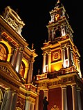
[edit]The city centre features a number of buildings dating back to the 18th and 19th and early 20th centuries. Clockwise around the Ninth of July Square are the neoclassical Cathedral Shrine, the French style Museum of Contemporary Art, the Cabildo (in former times, the city's town hall, nowadays a historical museum) and the neoclassical Museum of High Altitude Archaeology, which houses artifacts from the Inca civilization, including the mummies of three Inca children. The Plaza is almost completely surrounded by a gallery.
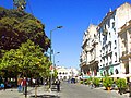
Within walking distance of the July 9th Square are the Saint Francis Church and the city's three pedestrian streets: Alberdi, Florida and "Caseros". The three blocks in Balcarce street closest to the train station are now the centre of night life in Salta, with restaurants, pubs and cafés on both sidewalks and concerts every night.
Rising in the east is San Bernardo Hill. Its summit, from which visitors can get a view of the city and the entire valley, can be reached by car, cable car or stairway.
-
 A cable car (gondola) in Salta near Plaza del Lago
 -
 The Church of Saint Francis
 -
 The main cathedral
 -
 Inside the cathedral
 -
 Mitre Street
 -
 The Colonial Hotel
 -
 Ninth of July Plaza
 -
 Corner newsstand in Salta
 -
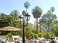
 Waterfountain and paddleboats to rent at Plaza del Lago in Salta


.jpg)


Culture and arts
[edit]
Salta is probably the most Spanish city in Argentina by physical appearance: so much so that tourists visiting from Spain often find a strong resemblance between Salta and Andalucian cities.[citation needed] The local culture, however, is a blend of Spanish and gaucho (mestizo, criollo, both indigenous and non-indigenous) traditions, lending the city a distinctive identity, somewhat different from the more European-like metropolises to the south.
The city boasts three theatres, several museums (one of which exhibits the perfectly preserved bodies of c. 500 year old Inca children sacrificed in the Andes to Inca gods[22]), and a busy calendar of art exhibitions, shows, music festivals, and other cultural events.
One of the main activities in Salta is the April Culture Festival, which lasts the entire month and offers a wide variety of activities such as cultural performances, a handcraft exposition, and live orchestral performances.
Sports
[edit]Salta residents, like most Argentines, are very enthusiastic about football. The most important local clubs are Juventud Antoniana, Gimnasia y Tiro de Salta, and Central Norte; many faithful fans follow each. These three clubs currently play in the third national division.
Other locally popular sports include baseball (a game in which Salta players excel nationally[citation needed]), basketball, volleyball, rugby, and mountaineering.
The main sporting venue in Salta is the Padre Ernesto Martearena Stadium; the Gimnasia y Tiro and Juventud Antoniana stadiums also see many athletic matches. The largest roofed facility in the city is the Ciudad de Salta Stadium, chiefly used for basketball, volleyball, and boxing.
Over the last forty years, Salta has played host to such high-profile international sporting events as the 1990 Basketball World Cup, the 1994 Camel Trophy, the 2002 Volleyball World Cup, and the 2009 Hockey Champions Challenge. The Argentina national rugby union team, the "Pumas", have played in Salta against Italy (2005),[23] England (2009),[24] (2013),[25] South Africa (2016)[26] and Scotland (2022).[27] Top football clubs, including Boca Juniors, River Plate and Racing, have played friendly games in Salta in summer, off-season matches.
The city was used as a stage on the route of the 2014 and 2016 Dakar Rally.
Politics of Salta
[edit]Salta is governed by a city council of 21 members. Following the elections of November 2013, the Workers' Party has 9 seats, the Justicialist Party has 6 seats, and there are 6 others.[citation needed]
Trivia
[edit]- The film Taras Bulba, starring Yul Brynner and Tony Curtis, was largely shot in the hills west of the city, near San Lorenzo.[28]
- Actor John Schneider (The Dukes of Hazzard and Smallville) was part of the cast of Cocaine Wars,[29] another film shot in Salta.
- Two Hollywood celebrities have married Salta natives: Matt Damon (to Luciana Bozán Barroso), and Robert Duvall (to Luciana Pedraza).[30]
Transportation
[edit]The city's commercial airline needs are served by Aeropuerto Internacional Martín Miguel de Güemes, with service on three domestic airlines, including Aerolineas Argentinas, which is Argentina's largest domestic and international air carrier, and low cost airline Flybondi.
Notable people
[edit]- Juana Dib (1924-2015), poet, journalist, and teacher
- Carlos Santiago Fayt, academic and judge
- Carlos Ibarguren, academic and politician
- César Isella, folk singer
- Christian Rodrigo Zurita, footballer
- Daniel Tinte, pianist and composer
- David Kavlin, television host
- Dino Saluzzi, bandoneonist and composer
- Emmanuel Cáceres, football player
- Francisco Gabino Arias, explorer and soldier
- Jorge Horacio Brito, banker and businessman
- José Alfredo Martínez de Hoz, former economy minister
- José Evaristo Uriburu, president of Argentina
- José Félix Uriburu, de facto president of Argentina
- Manuela Cornejo Sanchez, composer
- José Valdiviezo, footballer
- Juan Figallo, rugby player
- Juana Manuela Gorriti, feminist writer
- Los Chalchaleros, folk music band
- Los Nocheros, folk music band
- Luciana Pedraza, actress
- Luciano Leccese, footballer
- Lucrecia Martel, film director
- Luís Sillero, footballer
- Mariano Boedo, statesman
- Martín Miguel de Güemes, general
- Martina Silva de Gurruchaga, independence fighter
- Nadia Echazú, human rights activist
- Noemí Goytia, architect and professor
- Renato Riggio, footballer
- Robustiano Patrón Costas, infamous sugar tycoon
- Sara Solá de Castellanos, wrote the lyrics of the hymn of the city of Salta.
- Victorino de la Plaza, politician, president of Argentina
- Walter Busse, footballer
- Wilfred Benítez, Puerto Rican boxer
See also
[edit]References
[edit]- Di Fabio Rocca, Francisco; Albeza, María Virginia; Bárbara Postillone, María; Acreche, Noemí; Lafage, Lucía; Parolín, María Laura; Dejean, Cristina; Carnese, Francisco Raúl; Avena, Sergio (2016). "Historia poblacional y análisis antropogenético de la ciudad de Salta" (PDF). Andes (in Spanish). 27. Salta, Argentina. ISSN 0327-1676. Retrieved January 28, 2020.
Notes
[edit]- ^ "TelluBase—Argentina Fact Sheet (Tellusant Public Service Series)" (PDF). Tellusant. Retrieved 2024-01-11.
- ^ de Ramón Folch, José Armando (1953). Descubrimiento de Chile y Compañeros de Almagro (in Spanish). Instituto de Investigaciones Históricas. p. 50.
- ^ Rock, David (1985). Argentina, 1516-1982: From Spanish Colonization to the Falklands War. University of California Press. ISBN 978-0-520-05189-8.
- ^ "Historia y Geografía" (in Spanish). Municipality of Salta. Retrieved 5 February 2018.
- ^ "Datos Climáticos de Argentina: Annuales" (in Spanish). Retrieved April 12, 2013.
- ^ a b "Station Salta" (in French). Meteo Climat. Retrieved October 8, 2016.
- ^ "Salta, Salta". Estadísticas meteorológicas decadiales (in Spanish). Oficina de Riesgo Agropecuario. Retrieved June 19, 2015.
- ^ "Estadísticas Climatológicas Normales – período 1991–2020" (in Spanish). Servicio Meteorológico Nacional. Archived from the original on 3 March 2023. Retrieved 16 May 2023.
- ^ Nacional, Servicio Meteorológico (2023). "Estadísticas Climatológicas Normales – período 1991–2020" (PDF) (in Spanish). Servicio Meteorológico Nacional. Archived from the original on 8 July 2023. Retrieved 4 August 2023.
- ^ "Estadística climatológica de la República Argentina Período 1991-2000" (in Spanish). Servicio Meteorológico Nacional. doi:10.35537/10915/78367. Archived from the original on 9 May 2023. Retrieved 16 May 2023.
- ^ "87047: Salta Aerodrome (Argentina)". ogimet.com. OGIMET. 17 December 2023. Retrieved 19 December 2023.
- ^ "Estación Meteorológica (EM) Cerrillos-INTA" (in Spanish). Instituto Nacional de Tecnología Agropecuaria. Archived from the original on January 21, 2016. Retrieved July 13, 2015.
- ^ "Estación Meteorológica (EM) Cerrillos-INTA: Temperatura Máxima Absoluta (°C ) – Periodo 1969– 2009" (in Spanish). Instituto Nacional de Tecnología Agropecuaria. Retrieved July 13, 2015.
- ^ "Estación Meteorológica (EM) Cerrillos-INTA: Temperatura Máxima Media (°C ) – Periodo 1969– 2009" (in Spanish). Instituto Nacional de Tecnología Agropecuaria. Retrieved July 13, 2015.[permanent dead link]
- ^ "Estación Meteorológica (EM) Cerrillos-INTA: Temperatura Media (°C ) – Periodo 1969– 2009" (in Spanish). Instituto Nacional de Tecnología Agropecuaria. Retrieved July 13, 2015.
- ^ "Estación Meteorológica (EM) Cerrillos-INTA: Temperatura Mínima Media (°C ) – Periodo 1969– 2009" (in Spanish). Instituto Nacional de Tecnología Agropecuaria. Retrieved July 13, 2015.[permanent dead link]
- ^ "Estación Meteorológica (EM) Cerrillos-INTA: Temperatura Mínima Absoluta (°C ) – Periodo 1969– 2009" (in Spanish). Instituto Nacional de Tecnología Agropecuaria. Retrieved July 13, 2015.
- ^ "Estación Meteorológica (EM) Cerrillos-INTA: Precipitaciones Mensuales Periodo 1969 – 2009" (in Spanish). Instituto Nacional de Tecnología Agropecuaria. Retrieved July 13, 2015.[permanent dead link]
- ^ "Estación Meteorológica (EM) Cerrillos-INTA: Humdedad Relativa Media (%) Periodo 1969 – 2009" (in Spanish). Instituto Nacional de Tecnología Agropecuaria. Retrieved July 13, 2015.
- ^ "Estación Meteorológica (EM) Cerrillos-INTA: Heliofanía Relativa (Duración relativa del brillo solar) Periodo 1969 – 2009" (in Spanish). Instituto Nacional de Tecnología Agropecuaria. Retrieved July 13, 2015.[permanent dead link]
- ^ "Estación Meteorológica (EM) Cerrillos-INTA: Heliofanía Efectiva (Duración registrada del brillo solar) Periodo 1969 – 2009" (in Spanish). Instituto Nacional de Tecnología Agropecuaria. Retrieved July 13, 2015.
- ^ "Mummified Inca maiden wows crowds". BBC News. 2007-09-07. Retrieved 2014-04-22.
- ^ Argentina v Italy scorecard at Scrum.com
- ^ national teams Argentine rugby fans deserve annual Test, by Brendan Gallagher for The Telegraph
- ^ "England too strong for Argentina". Espn.co.uk. Retrieved 2014-04-22.
- ^ "Argentina v South Africa – Rugby Union". BBC Sport. Archived from the original on August 31, 2016. Retrieved 13 October 2017.
- ^ "Visitors bounce back with commanding win". BBC Sport. Retrieved 2022-07-13.
- ^ "CCA: When the pueblo was Hollywwod". Cca.edu. 2010-02-05. Archived from the original on 2013-07-18. Retrieved 2014-04-22.
- ^ U.S.-Argentine Co-productions, 1982–1990, by Tamara L. Falicov (University of Kansas), Page 7, Footnote 18
- ^ juliana (2006-07-12). "Robert Duvall's House of Jasmines". Hotelchatter.com. Archived from the original on 2014-09-09. Retrieved 2014-04-22.
External links
[edit] Salta travel guide from Wikivoyage
- Municipality of Salta — Official website
- Government of Salta Province — Official website
- City history at the Chamber of Deputies website
- Salta Province Tourism Office
- . New International Encyclopedia. 1905.
- . The American Cyclopædia. 1879.
| International | |
|---|---|
| National | |
| Geographic | |
| Other | |
Salta
View on GrokipediaGeography
Physical Features
Salta Province spans 155,488 square kilometers in northwestern Argentina, encompassing a varied topography influenced by the Andean orogeny and subtropical climatic gradients. The western sector features the arid Puna altiplano, a high plateau at elevations of 2,500 to 4,500 meters above sea level, punctuated by salt flats and volcanic formations, transitioning into the rugged Cordillera Oriental with peaks exceeding 5,000 meters, including Nevado del Azufre at 5,706 meters.[6][7][8] Central regions are dominated by subandean sierras and intermontane valleys, such as the fertile Valle de Lerma—where the capital city sits at approximately 1,187 meters—and the Calchaquí Valleys, characterized by deep quebradas with multicolored rock formations, like the Quebrada de las Conchas, formed by fluvial erosion over millions of years. These valleys, at 800 to 2,000 meters, support agriculture due to alluvial deposits and irrigation from Andean meltwater.[9][10] The eastern flank shifts to the humid Yungas ecoregion with forested subandean ranges and lower Chaco plains, descending to around 200 meters, where thorn scrub and savannas prevail amid seasonal flooding. Principal rivers, part of the Río de la Plata basin, include the Bermejo (originating in the sierras and forming the southern boundary), Juramento (or Pasaje, flowing southeast through valleys), and Pilcomayo (bordering to the north), with lengths exceeding 1,000 kilometers collectively and vital for sediment transport and water supply.[11][12][13]Climate and Environment
Salta Province spans diverse topographic zones, resulting in varied climates ranging from humid subtropical in the eastern Yungas foothills to semi-arid and highland arid conditions in the western Puna and Andean regions. The capital city of Salta experiences a subtropical highland climate classified as Cwb under the Köppen system, characterized by mild, dry winters and warm, rainy summers, with an annual average temperature of 16.5°C and precipitation concentrated between October and May, totaling around 755 mm yearly.[14][15]| Month | Avg Max (°C) | Mean (°C) | Avg Min (°C) | Precip (mm) |
|---|---|---|---|---|
| Jan | 29.9 | 23.6 | 17.3 | 111.8 |
| Feb | 28.6 | 22.7 | 16.8 | 104.4 |
| Mar | 27.1 | 21.3 | 15.4 | 72.1 |
| Apr | 24.2 | 18.5 | 12.8 | 25.4 |
| May | 21.3 | 15.6 | 9.8 | 8.1 |
| Jun | 19.3 | 13.4 | 7.5 | 2.8 |
| Jul | 19.7 | 13.3 | 6.9 | 2.5 |
| Aug | 22.1 | 15.3 | 8.4 | 1.5 |
| Sep | 24.4 | 17.6 | 10.7 | 10.2 |
| Oct | 26.6 | 20.0 | 13.3 | 31.2 |
| Nov | 28.1 | 21.6 | 15.1 | 60.2 |
| Dec | 29.4 | 23.1 | 16.7 | 85.2 |
History
Pre-Columbian and Indigenous Periods
The territory encompassing modern Salta Province hosted diverse indigenous societies for millennia before European arrival, with archaeological evidence indicating human presence dating back thousands of years in the Andean northwest. The Diaguita-Calchaquí peoples, among the most significant pre-Columbian groups, established settlements in the high valleys and puna plateaus around 1000 BC, practicing agriculture, ceramics production, and fortified villages adapted to the arid environment.[24] These communities cultivated crops such as maize and potatoes using terraced fields and developed distinctive polychrome pottery, reflecting influences from Andean highland cultures.[25] In the late pre-Columbian era, Inca expansion from the 15th century integrated parts of the Calchaquí Valleys into the Tawantinsuyu empire, marking the southern frontier of Inca influence in what is now Salta.[26] Inca engineering feats, including segments of the Qhapaq Ñan road network, facilitated control and resource extraction, with sites like Potrero de Payogasta featuring rectangular stone structures and agricultural terraces.[27] Ritual practices culminated in capacocha sacrifices, evidenced by the mummified remains of three Inca children discovered in 1999 on Mount Llullaillaco at 6,739 meters elevation, preserved by subzero temperatures and dating to approximately 1500 AD; analysis reveals they were selected from diverse regional origins and ritually killed via blunt trauma or exposure.[28] [29] Indigenous groups such as the Diaguita and Calchaquí maintained semi-autonomous polities centered on kinship-based agrarian economies, engaging in llama herding, weaving, and inter-valley trade networks predating Inca arrival.[30] Post-Inca persistence of these cultures is attested by archaeological continuity in ceramics and settlement patterns, though direct Inca overlay introduced metallurgical techniques and administrative tampus. Larger pre-Inca sites, including those in the North Calchaquí Valley, demonstrate interactions with non-human entities in ritual landscapes, underscoring cosmological ties to sacred peaks and water sources.[31] Archaeological surveys reveal over 100 sites with stone enclosures and burial urns, highlighting defensive adaptations against environmental and intergroup pressures.[32]Colonial Era and Spanish Settlement
The city of Salta was founded on April 16, 1582, by Hernando de Lerma, governor of Tucumán, on the banks of the Arenales River as the "City of Lerma in the Salta Valley" to serve as a defensive outpost against indigenous incursions and a hub for commerce linking Santiago del Estero to Peru.[33] The settlement was renamed San Felipe de Lerma the following day in honor of King Philip II of Spain.[33] This founding occurred amid broader Spanish colonization efforts in the Tucumán region, which had begun definitively in 1550 following exploratory expeditions from Peru starting around 1535.[33] De Lerma, appointed governor in 1577 by Philip II, aimed to consolidate Spanish control in the northwest by establishing secure routes for resource extraction and transport, particularly supporting the flow of goods to and from the silver-rich Potosí mines.[34] During the colonial period, Salta functioned under the Viceroyalty of Peru until 1776, when administrative reforms transferred it to the newly formed Viceroyalty of the Río de la Plata; by 1784, it hosted the headquarters of the Service Corps for regional defense and logistics.[33] [35] Salta's economy centered on its role as a key intermediary in trade networks spanning from Callao in Peru to Buenos Aires, facilitating the movement of silver, cattle (via taxes to Upper Peru), and other goods while exporting mules critical for mining, agriculture, and transportation in the Andes—exports from Salta to Peru between 1778 and 1808 underscored this dependency.[33] [36] The region also produced agricultural commodities such as sugar and tobacco, though persistent indigenous resistance and trade interruptions posed challenges, partly addressed by influxes of African-descended laborers who comprised 46% of the population by 1778.[2] [33]Independence Wars and 19th-Century Development
Salta emerged as a key frontline in the Argentine War of Independence, hosting pivotal engagements that bolstered patriot forces in the northwest. On February 20, 1813, General Manuel Belgrano's Army of the North decisively defeated royalist troops commanded by Pío de Tristán in the Battle of Salta, compelling an unconditional surrender and consolidating control over northern territories previously contested by Spanish forces.[37] This victory followed Belgrano's earlier success at Tucumán and prevented royalist advances from Upper Peru, enabling supply lines for further campaigns. Martín Miguel de Güemes, appointed governor of Salta in 1815, orchestrated an effective guerrilla defense against repeated Spanish incursions from the Andes. Employing local gauchos in hit-and-run tactics, Güemes disrupted royalist logistics and supply routes originating from Peru, safeguarding the province and Tucumán until his assassination on June 7, 1821.[38] His strategies, which included night raids and scorched-earth policies, tied down thousands of royalist troops, contributing significantly to the eventual collapse of Spanish resistance in the region.[39] Following independence, Salta aligned with federalist interests amid the Argentine Civil Wars, resisting centralist policies from Buenos Aires and favoring provincial autonomy under caudillo leadership. The province experienced internal strife and power struggles in the decades after Güemes' death, including conflicts over governance and resources that echoed broader unitarian-federalist divides, though Salta maintained relative autonomy early on.[40] These tensions persisted through mid-century upheavals, with local elites consolidating power amid intermittent violence. Economic development in 19th-century Salta centered on subsistence agriculture and livestock rearing, gradually incorporating cash crops as markets expanded. By the late 1800s, sugar cane cultivation proliferated in the fertile Lerma Valley, supported by ingenios (sugar mills) owned by prominent Salta families, alongside tobacco production for export.[41] Yerba mate and citrus also gained traction, though the province's peripheral status limited integration until railway extensions in the 1880s facilitated trade with central Argentina, boosting agricultural exports like beef and sugar.[42] Indigenous labor, particularly from Kolla communities, underpinned much of the sugar industry, often under exploitative conditions.[43] This shift marked Salta's transition from a frontier outpost to a modestly industrialized agrarian economy within the nascent Argentine nation.20th Century to Present
In the early 20th century, Salta Province's economy centered on latifundista-style livestock production, supplemented by agriculture such as sugar cane cultivation in the eastern lowlands and tobacco farming, which provided limited export revenue amid national export-oriented growth elsewhere in Argentina.[43][44] Marginal participation in the agro-export model persisted due to geographic isolation and poor infrastructure, with manufacturing negligible until later decades.[44] Territorial adjustments occurred in 1902 when highland departments including Rosario de la Frontera and San Antonio de los Cobres were transferred from Salta to form the National Territory of Los Andes, reducing Salta's area to facilitate administration of remote Andean zones.[45] This territory was dissolved in 1943, with its departments reintegrated into Salta Province, restoring pre-1902 boundaries and enhancing control over mineral-rich puna regions.[46] Mining saw moderate expansion in the first half of the century, driven by discoveries of tungsten, tin, lead, and zinc deposits, though output remained secondary to agriculture until post-1950s infrastructure improvements.[47] A devastating earthquake on February 20, 1930, magnitude 7.1, struck the province, causing over 100 deaths, widespread destruction in the capital, and economic setbacks that delayed modernization efforts. (Note: While Wikipedia is not cited, event verified via multiple seismic records; primary data from USGS archives confirm impacts.) From the 1940s onward, Peronism gained strong footholds in Salta's politics, reflecting the movement's appeal to rural workers and provincial elites amid national labor reforms and industrialization pushes.[48] Following Juan Perón's 1955 overthrow, Salta faced federal intervention until 1958, after which Peronist Miguel Ragone assumed the governorship, initiating a pattern of Peronist dominance interrupted by military interventions.[48] The 1976-1983 military regime imposed aligned local administrations, suppressing opposition and contributing to human rights violations documented in provincial contexts, though Salta experienced fewer documented disappearances than urban centers. The return to democracy in 1983 under Raúl Alfonsín brought economic liberalization attempts, but hyperinflation and national debt crises exacerbated Salta's underdevelopment, with sugar industry employment peaking at over 20,000 workers before subsidies cuts led to mill closures by the 1990s.[47] Under Carlos Menem's 1989-1999 presidency, provincial governors like Antonio Domingo Bussi (1983-1986, military-linked) and later Juan Carlos Romero (1991-1999, Peronist) pursued neoliberal alignments, fostering gas exploration in the Valles Calchaquíes and early foreign investment, though corruption allegations plagued administrations.[48] Into the 21st century, Salta's economy diversified with natural gas production reaching 10 million cubic meters daily by 2010 and a mining resurgence, including copper and gold projects, generating over US$100 million in annual exports by the mid-2000s.[49] Lithium extraction emerged as a priority in the northern salt flats, part of Argentina's "Lithium Triangle," with investments exceeding US$1 billion by 2020 from firms like Livent and Alpha Lithium, amid debates over environmental impacts on indigenous communities.[50] Tourism grew post-2000, leveraging colonial architecture and Andean landscapes, contributing 5-7% to GDP by 2015 through sites like the Train to the Clouds.[51] Politically, Peronist continuity persisted under governors like José Urtubey (2007-2019) and Gustavo Sáenz (2019-present), navigating national shifts including the 2001-2002 crisis and Milei's 2023 libertarian reforms, which prompted provincial fiscal adjustments amid inflation exceeding 200% in 2023.[48]Demographics
Population Trends
The population of Salta, the capital city of Salta Province, has grown steadily since the mid-20th century, driven primarily by rural-to-urban migration within the province and natural population increase, though at a decelerating rate in recent decades reflecting national demographic transitions such as declining fertility.[52] This urbanization mirrors broader patterns in Argentina's Northwest region, where economic opportunities in administration, services, and emerging sectors like tourism and mining have attracted migrants from rural areas affected by agricultural modernization and climate variability.[52] By concentrating a significant share of the provincial population—approximately 43% in 2022—the city has served as a demographic hub, with its metropolitan area expanding to encompass adjacent localities.[52] Census data from Argentina's National Institute of Statistics and Censuses (INDEC) illustrate this trajectory for the Capital Department, which aligns closely with the city's core urban population:| Census Year | Population | Decadal Growth Rate (%) |
|---|---|---|
| 1991 | 367,550 | - |
| 2001 | 462,051 | 25.7 |
| 2010 | 529,000 | 14.5 (approx., 2001-2010) |
| 2022 | 627,704 | 18.6 (approx., 2010-2022) |