

Community hub
Recent from talks
Contribute something
Nothing was collected or created yet.
Teqoa
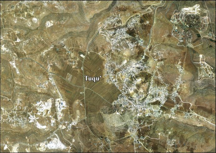
View on WikipediaTeqoa (Arabic: تقوع, also spelled Tuquʿ) is a Palestinian town in the Bethlehem Governorate, located 12 km (7.5 mi) southeast of Bethlehem in the land Samaria And Judah West Bank. The town is built adjacent to the biblical site of Tekoa (Hebrew: תְּקוֹעַ, romanized: Təqōaʿ; also called Thecoe), now Khirbet Tuqu', from which it takes its name. Today's town includes three other localities: Khirbet ad-Deir,[4] al-Halkoom, and Khirbet Teqoa.[5] According to the Palestinian Central Bureau of Statistics (PCBS), Teqoa had a population of 8,767 in 2017.[2]
Key Information
![A sketch of "Tekoa - Fureidis, Palestine"[1]](https://en.wikipedia.org/wiki/File:Tekoa_-_Fureidis,_p._425_in_Thomson,_1859_cropped.jpg)

The town is a part of the 'Arab al-Ta'amira village cluster, along with Za'atara, Beit Ta'mir, Hindaza, Khirbet ad-Deir, Nuaman, Ubeidiya and al-Asakra. Tuqu has a municipal jurisdiction of over 191,262 dunams, but its built-up area consists of 590 dunams,[5] as 98.5% of the village's land was classified as Area C, and 1.5% as Area B in the 1995 accords.[6] Situated in the immediate vicinity is the modern Israeli settlement of Tekoa, established in 1975 as a military outpost. Israeli settlements in the occupied West Bank, including East Jerusalem, are illegal under international law.[7]
Etymology
[edit]Strong's Concordance states that Tekoa means in Hebrew "a stockade".[8] Gesenius' lexicon uses "the pitching" in reference to tents.[9]
Location
[edit]Teqoa is located 12 km (horizontal distance) south-east of Bethlehem. It is bordered by Teqoa wilds to the east, Jannatah town to the north, Al Manshiya and Marah Rabah to the west, and Al Maniya and Kisan villages to the south.[10]
In the Hebrew Bible
[edit]According to biblical sources, Ephrathites from Bethlehem and the Calebites from Hebron founded Teqoa.[citation needed] Samuel speaks of a "wise woman" of Tekoa in the time of David (2 Samuel 14:2).[11] King Rehoboam fortified the city and made it strategically important (2 Chronicles 11:6).[11] The people of Teqoa who returned from Babylon were Calebites (1 Chronicles 2:24), and they participated in rebuilding the walls of Jerusalem (Nehemiah 3:5,27).[11]
Identification
[edit]The location of biblical Teqoa is well defined in Scripture.[11] In the Jewish Encyclopedia (1901), Isidore Singer notes that "the Greek text of a passage (Joshua 15:59) lost in the Hebrew [i.e., in the Masoretic Text (Joshua 15:60)] places it, together with Bethlehem and other towns of the hill-country of Judah, south of Jerusalem".[11] Singer offers as secure the identification of the site at "Khirbat Taḳu'ah".[11] Jeremiah places Teqoa in the south (Jeremiah 6:1), and two other passages speak about the desert, or wilderness, of Tekoa (2 Chronicles 20:20 and 1 Maccabees 9:33).[11] However, Amos 1:1 describes the prophet as "a herdsman of Tekoa", suggesting that the land was reasonable for shepherding.[citation needed]
Archaeology of Khirbet Teqoa
[edit]
Teqoa, the town known from the Hebrew Bible and other classical ancient sources, has been identified with Khirbet Teqoa ("ruins of Teqoa"), immediately east of modern Teqoa,[12] both of which are c. 5 miles (8 km) south of Bethlehem,[13] also spelled Khirbet al-Tuq'u.[14][15]
Various ruins were seen at the site in the mid-19th century. These included the walls of houses, cisterns, broken columns and heaps of building stones, some of which had "bevelled edges" which supposedly indicated ancient Jewish origin.[16]
History of excavation
[edit]Khirbet Teqoa (Grid Ref. 170100/115600), has been excavated by Martin Heicksen (1968), John J. Davis (1970), and Sayf al-Din Haddad (1981).[17]
Periods
[edit]The main periods of habitation brought to light by archaeological digs at Khirbet Teqoa are the Iron Age II, and the Byzantine period.[17] Less well represented are the Iron Age IIb, Persian, Early and Late Roman, and medieval (Crusader to Mamluk) periods.[17]
Byzantine-period remnants
[edit]The Bible indicates Teqoa as the birthplace of prophet Amos, and from the 4th century CE on a tomb alleged to be his was said to be visible at the village.[15] A chapel built over the tomb is attested in the 6th century and is mentioned again in the 8th.[15] The ruins consist of a double cave over what was a baptismal font, mosaic floors; a Monophysite monastery is located near the tomb.[12] Byzantine ceramics have been found.[18] The remains of the Byzantine church and monastery are still visible.[12][19]
When Victor Guérin visited the site in 1863, he described the remains of an almost completely destroyed church, and an octagonal baptismal font, carved into a monolithic block of reddish limestone, measuring a meter and ten centimeters deep inside, and one meter thirty centimeters in diameter. On different sides of the octagon crosses were carved. At the bottom of the baptismal font the water flowed through an opening into a tank.[20] The Survey of Western Palestine, with data collected between 1872 and 1877, refers again to the font: "There is also a very fine octagonal font about 4 feet high and 4 feet 3 inches diameter of inscribed circle; on every other side is a design. Two of these designs represent crosses, a third is a wreath, the fourth is formed by two squares interlaced diagonally to one another. The font is of good reddish stone."[21]
A magical amulet etched on a silver plate and written in Aramaic is among the findings from the Byzantine period. The amulet contains 16 lines, 11 of which use Hebrew script; the others show magic characters. It dates to the fifth to seventh centuries CE, and is currently located in the SBF Museum, Jerusalem.[22]
Other archaeological sites and landmarks
[edit]
The site of Khirbet Teqoa is considered "qualified in terms of tourism".[5] A second archaeological site near Teqoa, Khirbet Umm El 'Amd, is "not qualified" in terms of tourism.[5]
The New Lavra of Saint Sabbas (est. 507 by Sabbas the Sanctified) is today in ruins at the site of Bir el-Wa'ar, c. 3 km south of Tuqu'.[23]
Paleolithic caves in Wadi Khureitun
[edit]Outside Teqoa, adjacent to the Israeli settlement of Tekoa is Wadi Khureitun,[15] sometimes spelled Khreiton ("Chariton Valley"). The valley is notable for containing three prominent caves inhabited since the Paleolithic era: Umm Qatfa, Umm Qala'a and Erq al-Ahmar. The latter was inhabited since 8,000 BCE and traces of fire have been found in Umm Qala'a, dating back 500,000 years.[24]
History of Teqoa
[edit]Hellenistic period
[edit]During the Maccabean Revolt it was fortified by the Greek general Bacchides (Josephus, Ant. XIII, 15).[13]
Roman period
[edit]Josephus again mentions Teqoa in connection with the First Jewish–Roman War (Life 420, War IV, 518).[13]
Eusebius (c. 260s-340) mentions a village by the name of Teqoa (Onomasticon 98:17, etc.).[13]
Byzantine period
[edit]Teqoa is again mentioned in Byzantine sources.[13]
Muslim conquest and Early Muslim period
[edit]Teqoa was captured during the Muslim conquest of Syria and with time, several of its inhabitants converted to Islam. There was a significant nomadic Bedouin presence in the village's vicinity.[14]
Crusader and Ayyubid period
[edit]Teqoa was known as "Casal Techue" by the Crusaders who conquered Palestine in 1099. Its Christian residents welcomed the Crusaders.[14] Medieval chronicler William of Tyre relates that the Christians of the village aided the Crusaders during the Siege of Jerusalem in 1099, by guiding them to local springs and food sources. Many of the villagers also joined the Crusader army.[25]
In 1108, the Russian traveller Abbot Daniel noted that Casal Techue was "a very big village" with a mixed Christian and Muslim population.[14] The village was granted by King Fulk and Queen Melisende to the canons of the Holy Sepulchre in 1138 in exchange for Bethany, the concession allowing the inhabitants to collect bitumen and 'salt' from the Dead Sea shores.[15][14] The area's population included villeins comprising local Christians and Muslims, the latter being Islamised former Christians, and apparently also recent Frankish (West European) settlers, with Bedouin living outside the village.[14]
The ruins of a castle, a Frankish manor house[14] from the period, are found at Khirbat at-Teqoa at the edge of the biblical and Byzantine archaeological mound, some 41x48x60 m in size, and protected by a rock-cut ditch.[15][26]
Zengid forces captured Casal Techue in 1138. The Knights Templar under Robert the Burgundian managed to recapture the town easily, but experienced their first military defeat when Zengid forces counterattacked, leaving the area between the town and Hebron "strewn with Templar bodies" according to William of Tyre. He blamed the Templars' defeat on their failure to pursue fleeing Muslim forces which allowed them to regroup just outside Casal Techue.[27]
Syrian geographer Yaqut al-Hamawi described it as "a village famous for its honey" during a visit there in 1225,[15][28] during Ayyubid rule.
Ottoman period
[edit]Teqoa, like all of Palestine, was incorporated into the Ottoman Empire in 1517. According to an Ottoman census in 1526, 82 families lived in the village, 55 of which were Christians.[14] In 1596 the village appeared in Ottoman tax registers as being in the Nahiya of Quds of the Liwa of Quds. It had a population of 62 Muslim households and five Christian households. The villagers paid taxes on wheat, barley, olives, vines or fruit trees, and goats or beehives; a total of 27,000 akçe. All of the revenue went to a waqf.[29]
The majority of Teqoa's Christian inhabitants emigrated to Bethlehem in the 18th century.[12] Teqoa's Christian migrants formed Bethlehem's Qawawsa Quarter.[19]
French explorer Victor Guérin visited the place in 1863, and he described finding the scarce remains of a church, and an octagonal baptismal font.[20]
The PEF's Survey of Western Palestine in 1883 mentions that Khurbet Tequa "seems to have been large and important in Christian times. It is still inhabited by a few persons living in the caves [...]"[21]
Jordanian period
[edit]The modern town of Teqoa was established in 1948 during Jordanian rule.[5][30] The inhabitants were Bedouin tribesmen from the 'Arab al-Ta'amira tribe.[5][30] In 1961, the population was 555.[31]
Post-1967
[edit]
During the Six-Day War in 1967, Teqoa came under Israeli occupation, remaining so until this day. The population in the 1967 census conducted by the Israeli authorities was 1,362.[32]
Over the years, Israel has confiscated 1,436 dunams of Teqoa's land for the construction of three Israeli settlements: Tekoa, Mitzpe Shalem, and a resort, Metzoke Dragot. In addition, the settlers have constructed various outposts.[33]
In May 2001, after the killing of two Jewish Israeli boys outside the nearby Israeli settlement of Tekoa, Teqoa was temporarily sealed off by the Israeli Army. Consequently, residents could not reach their jobs in Bethlehem and Israel, and shepherds could not reach grazing lands outside the village.[34]
Demographics
[edit]According to a 1997 census by the Palestinian Central Bureau of Statistics (PCBS), Teqoa had a population of 4,890 inhabitants. There were only 24 Palestinian refugees, making up 0.5% of the population.[35] There were 2,534 males and 2,356 females.[36] Tuqu's population grew to 8,881 in the 2007 PCBS census. There were 1,368 households, with the average household size consisting of between six and seven members. The gender ratio was 49% women and 51% men.[37]
Teqoa has a Muslim majority and there are ten mosques in the town. They are the following: Abu Bakr as-Siddik Mosque, Bilal Ibn Rabah Mosque, al-Sahaba Mosque, al-Tawba Mosque, Abd al-Rahman Ibn 'Oof Mosque, Zaid Ibn Haritha Mosque, al-Abbas Mosque and Salah ad-Deen Mosque, al-Ansar Mosque and Ali Ibn Abi Talib Mosque. Most of the inhabitants belong to the 'Arab al-Ta'amira tribe. Principal clans include Badan, Jibreen, Sha'er, 'Emur, Nawawra, 'Urooj, Abu Mifrih, az-Zawahra, Sbeih, at-Tnooh, Sleiman and Sabbah.[5]
Tuqu' is one of the villages of the Ta'amra tribe. There are people who trace their origins to Tuqu' that now live in Tarqumiya.[38]
Economy
[edit]Agriculture, particularly livestock, dominates Teqoa's economy. Dairy is produced and sold in local markets and in Bethlehem. Industry is virtually nonexistent, although there is a stone quarry and brick factory in the town. Unemployment is high at about 50% and mostly caused by Israeli restrictions on movement and access to the labor market in Israel proper as a result of the Second Intifada between 2000 and 2004.[5]
As of 2008 around 45% of Teqoa's workforce was employed in the Israeli labor market while another 30% worked in agriculture. The remainder of economic activity was split between employment in the Palestinian government or trade and services.[5] Efforts have been made to attract tourists. A municipal center was built near the ruins of a Byzantine church in Teqoa.[34] Tuqu' is well known for its vegetables.[12]
Government
[edit]98.5% of Teqoa's land area has been located in Area C (West Bank), or Nature reserves since 1995, thus giving the Palestinian National Authority no control over its administration and civil affairs. Originally, twelve tribal elders managed the town, but unable to plan and carry out internal improvements, they ceded their power to a council of younger men.[39] The 13-member municipal council was established in 1997 to administer Teqoa as well as the villages of Khirbet al-Deir, al-Halqum and Khirbet Tuqu' which were put under Tuqu's jurisdiction.[5] Its first mayor, Suleiman Abu Mufarreh, initiated the construction of the municipal hall and recovered Tuqu's stolen baptismal font, relocating it to the front of the municipal hall.[39]
Teqoa is governed by a municipal council consisting of eleven members, including the mayor. In the 2005 Palestinian municipal elections, the Hamas-backed Reform list won the majority of the seats (eight), while the independent local United Teqoa list won three. Reform member Khaled Ahmad Hamida won the post of mayor, succeeding Raed Hamida.[40]
References
[edit]- ^ Thomson, 1859, p. 425
- ^ a b Preliminary Results of the Population, Housing and Establishments Census, 2017 (PDF). Palestinian Central Bureau of Statistics (PCBS) (Report). State of Palestine. February 2018. pp. 64–82. Retrieved 2023-10-24.
- ^ Palmer, 1881, p. 402
- ^ not be confused with Khirbet al-Deir in Hebron Governorate
- ^ a b c d e f g h i j Tuqu' Town Profile, Applied Research Institute-Jerusalem, 2008. Retrieved on 2012-03-13.
- ^ '15 Palestinians detained in Tuqu near Bethlehem', Ma'an News Agency 19 March 2015.
- ^ "The Geneva Convention". BBC News. 10 December 2009. Retrieved 27 November 2010.
- ^ Lexicon :: Strong's H8620 - Tĕqowa`, accessed 7 August 2018
- ^ Gesenius' Hebrew-Chaldee Lexicon s.v. תְּקוֹעַ
- ^ Teqoa Town Profile, ARIJ, p. 4
- ^ a b c d e f g Singer, I., The 1901 Jewish Encyclopedia - Tekoa, accessed 25 July 2017
- ^ a b c d e Taqou' village (1998) Mitri Raheb and Fred Strickert, Bethlehem 2000: Past and Present, Palmyra publishing house, 1998, via This Week in Palestine
- ^ a b c d e Negev and Gibson, 2001, p. 496
- ^ a b c d e f g h Ellenblum, 2003, pp. 136-137
- ^ a b c d e f g Pringle, 1998, pp. 347-348
- ^ William Aldis Wright; et al. (1865). Sir William Smith (ed.). A concise dictionary of the Bible for the use of families and students. London: John Murray. p. 924. Retrieved 4 September 2018.
- ^ a b c Greenberg, Raphael; Keinan, Adi (2009). "Kh. Teku'a (853)". Israeli Archaeological Activity in the West Bank 1967 - 2007: A Sourcebook (PDF). The West Bank and East Jerusalem Archaeological Database Project. pp. 126, 157, 160. ISBN 978-965-91468-0-2. Archived from the original (PDF) on 29 September 2012. Retrieved 3 April 2020.
Publications: Davis, J.J. 1974. Tekoa Excavations: Tomb 302. Bulletin of the Near East Archaeological Society, New Series, 4:27-49. Herr, L.G. 1986. A Seventh Century B.C. Tomb Group from Tekoa. In: L.T. Geraty and L.G. Herr (eds.), The Archaeology of Jordan and Other Studies. Berrien Springs, MI: 265-284.
- ^ Dauphin, 1998, p. 928
- ^ a b Teqoa area[permanent dead link] Zeiter, Leila. Centre for Preservation of Culture and History.[dead link]
- ^ a b Guérin, 1869, p. 141
- ^ a b Conder and Kitchener, 1883, SWP III, p. 368
- ^ Corpus inscriptionum Iudaeae/Palaestinae: a multi-lingual corpus of the inscriptions from Alexander to Muhammad. Vol. IV: Iudaea / Idumaea. Eran Lupu, Marfa Heimbach, Naomi Schneider, Hannah Cotton. Berlin: de Gruyter. 2018. pp. 823–825. ISBN 978-3-11-022219-7. OCLC 663773367.
{{cite book}}: CS1 maint: others (link) - ^ Bir el-Wa'ar - NEA LAURA. HUJI website 2022. Accessed 21 Feb 2022.
- ^ Wadi Khreitoun[permanent dead link] Zeitar, Leila. Centre for Cultural Heritage Preservation.
- ^ Thekoa - (Tuqu'a) Archived 2013-03-18 at the Wayback Machine Studium Biblicum Franciscanum - Jerusalem.
- ^ Pringle, 1997, p. 103
- ^ Howarth, Stephen. (1991). The Knights Templar Barnes & Noble Publishing, p.97.
- ^ Le Strange, 1890, p. 542
- ^ Hütteroth and Abdulfattah, 1977, p. 114
- ^ a b Kark and Oren-Nordheim, 2001, pp. 202, 241, 279 ff
- ^ Government of Jordan, Department of Statistics, 1964, p. 23
- ^ Perlmann, Joel (November 2011 – February 2012). "The 1967 Census of the West Bank and Gaza Strip: A Digitized Version" (PDF). Levy Economics Institute. Retrieved 24 June 2016.
- ^ Teqoa Town Profile, ARIJ, pp. 17–18,
- ^ a b Prophet Amos's Words Still Ring True Archived 2008-10-25 at the Wayback Machine Abu Ghazaleh, Sami. International Center of Bethlehem
- ^ Palestinian Population by Locality and Refugee Status Archived 2008-11-18 at the Wayback Machine (1997) Palestinian Central Bureau of Statistics (PCBS)
- ^ Palestinian Population by Locality, Sex and Age Groups in Years Archived 2012-01-11 at the Wayback Machine (1997) Palestinian Central Bureau of Statistics (PCBS)
- ^ 2007 PCBS Census Archived December 10, 2010, at the Wayback Machine Palestinian Central Bureau of Statistics. p. 117
- ^ Grossman, D. (1986). "Oscillations in the Rural Settlement of Samaria and Judaea in the Ottoman Period". in Shomron studies. Dar, S., Safrai, S., (eds). Tel Aviv: Hakibbutz Hameuchad Publishing House. p. 370
- ^ a b Levin, Jerry. Save our heritage in the Holy Land Al-Ahram Weekly. October 2003.
- ^ Local Elections (Round two)- Successful candidates by local authority, gender and No. of votes obtained Archived 2007-06-30 at the Wayback Machine Central Elections Commission - Palestine, p.25
Bibliography
[edit]- Conder, C.R.; Kitchener, H.H. (1883). The Survey of Western Palestine: Memoirs of the Topography, Orography, Hydrography, and Archaeology. Vol. 3. London: Committee of the Palestine Exploration Fund.
- Dauphin, C. (1998). La Palestine byzantine, Peuplement et Populations. BAR International Series 726 (in French). Vol. III : Catalogue. Oxford: Archeopress. ISBN 0-860549-05-4.
- Ellenblum, R. (2003). Frankish Rural Settlement in the Latin Kingdom of Jerusalem. Cambridge University Press. ISBN 0521521874.
- Government of Jordan, Department of Statistics (1964). First Census of Population and Housing. Volume I: Final Tables; General Characteristics of the Population (PDF).
- Guérin, V. (1869). Description Géographique Historique et Archéologique de la Palestine (in French). Vol. 1: Judee, pt. 3. Paris: L'Imprimerie Nationale.
- Hütteroth, W.-D.; Abdulfattah, K. (1977). Historical Geography of Palestine, Transjordan and Southern Syria in the Late 16th Century. Erlanger Geographische Arbeiten, Sonderband 5. Erlangen, Germany: Vorstand der Fränkischen Geographischen Gesellschaft. ISBN 3-920405-41-2.
- Kark, R.; Oren-Nordheim, Michal (2001). Jerusalem and its environs : quarters, neighborhoods, villages, 1800-1948. Detroit, Jerusalem: Wayne State University Press; Hebrew Univ. Magnes Press [u.a.] pp. 202, 241, 279ff. ISBN 978-0814329092. Retrieved 12 October 2015.
- Le Strange, G. (1890). Palestine Under the Moslems: A Description of Syria and the Holy Land from A.D. 650 to 1500. Committee of the Palestine Exploration Fund.
- Negev, Avraham; Gibson, S. (2001). xxx. New York and London: Continuum. ISBN 0-8264-1316-1.
{{cite book}}:|work=ignored (help) - Palmer, E.H. (1881). The Survey of Western Palestine: Arabic and English Name Lists Collected During the Survey by Lieutenants Conder and Kitchener, R. E. Transliterated and Explained by E.H. Palmer. Committee of the Palestine Exploration Fund.
- Pringle, D. (1997). Secular buildings in the Crusader Kingdom of Jerusalem: an archaeological Gazetter. Cambridge University Press. ISBN 0521-46010-7.
- Pringle, D. (1998). The Churches of the Crusader Kingdom of Jerusalem: L-Z (excluding Tyre). Vol. II. Cambridge University Press. ISBN 0-521-39037-0.
- Robinson, E.; Smith, E. (1841). Biblical Researches in Palestine, Mount Sinai and Arabia Petraea: A Journal of Travels in the year 1838. Vol. 2. Boston: Crocker & Brewster. (pp. 183 ff, Tekoa)
- Röhricht, R. (1893). (RRH) Regesta regni Hierosolymitani (MXCVII-MCCXCI) (in Latin). Berlin: Libraria Academica Wageriana. (pp. 43-44, no. 174)
- Thomson, W.M. (1859). The Land and the Book: Or, Biblical Illustrations Drawn from the Manners and Customs, the Scenes and Scenery, of the Holy Land. Vol. 2 (1 ed.). New York: Harper & brothers.
External links
[edit]- Welcome To Taqu'
- Tekoa, Welcome to Palestine
- Survey of Western Palestine, Map 21: IAA, Wikimedia commons
- Tuqu' Town (Fact Sheet), Applied Research Institute–Jerusalem (ARIJ)
- Tuqu’ Town Profile, ARIJ
- Tuqu’ aerial photo, ARIJ
| Cities |  | |
|---|---|---|
| Municipalities | ||
| Villages |
| |
| Religion | ||
| Refugee camps | ||
| Other | ||
| Authority control databases: National |
|---|
Teqoa
View on GrokipediaGeography and Location
Topographical Features
Teqoa is situated in the Judean Hills, within the Bethlehem Governorate of the West Bank, at an average elevation of 727 meters above sea level, though the ancient ruins at Khirbet Tequ'a occupy a prominent ridge reaching approximately 825 meters.[6][7] The terrain consists of undulating limestone hills characteristic of the central Judean highlands, with rocky outcrops and karst features formed by erosion over millennia.[8] To the east, the landscape abruptly transitions into the Judean Desert, marked by steep descents into deep wadis, sparse vegetation, and arid badlands that slope toward the Dead Sea Rift Valley, approximately 20 kilometers distant.[9] The site's elevated position provides panoramic vistas westward over the hill country toward Bethlehem (5 kilometers north) and Jerusalem (16 kilometers northwest), including visibility of the Mount of Olives on clear days, while eastward views encompass the rugged wilderness expanse.[8] Local topography includes incised valleys such as Nahal Tekoa, which encircles the area on multiple sides, creating natural defensive contours and facilitating seasonal flash floods that shape the fluvial geomorphology.[10] Soils are predominantly thin terra rosa over calcareous bedrock, supporting limited terraced agriculture on the slopes but transitioning to barren expanses in the desert fringe.[11]Strategic Position and Proximity to Key Sites
Teqoa is perched in the Judean Hills at an elevation of around 675 meters above sea level, commanding views over the eastern slopes descending into the Judean Wilderness and toward the Dead Sea rift valley. This elevated topography historically conferred defensive advantages, positioning the settlement as a frontier outpost guarding eastern approaches to Jerusalem against incursions from the wilderness. King Rehoboam fortified Teqoa as part of a chain of Judean strongholds to bolster regional security (2 Chronicles 11:6), and its ramparts remained operational into the era of Jeremiah as a signal station for military alerts (Jeremiah 6:1).[8][7] The site's strategic perch also facilitated control over caravan and pilgrimage routes skirting the wilderness, maintaining relevance through the Hellenistic-Roman periods when figures like Antiochus IV leveraged its vantage for regional dominance. Overlooking ancient paths eastward, Teqoa provided surveillance of trails connecting to Dead Sea oases, underscoring its role in securing trade and communication lines amid the arid frontier.[12] In terms of proximity to key sites, Teqoa lies approximately 16 kilometers (10 miles) south of Jerusalem, placing it within a day's march of the capital for rapid reinforcement. It is situated about 9 kilometers (six Roman miles) southeast of Bethlehem, facilitating interactions with that regional hub. To the northwest, Herodium—Herod the Great's fortified palace and mausoleum—stands just a few kilometers distant, linking Teqoa to Herodian-era infrastructure and defensive networks. Further east, the ruins afford oversight of roads descending to En Gedi, roughly 40 kilometers away along the Judean escarpment, a biblical refuge and oasis site associated with David (1 Samuel 24:1).[7][13][14][10]Etymology and Identification
Linguistic Origins
The name Teqoa (Hebrew: תְּקוֹעַ, Teqoa) originates from the Semitic root *t-q-', specifically the verb תקע (taqa'), denoting "to blow," "to thrust," or "to drive in" with sudden force, as in sounding a horn or trumpet.[15] This root gives rise to the noun תקוע (taqoa'), meaning "trumpet" or "blast," evoking imagery of signaling or proclamation, which aligns with the town's strategic highland position for watchtowers and alarms in ancient Judah.[15] [16] In biblical Hebrew, the place name thus carries connotations of a fortified or signaling site, reinforced by textual references like Jeremiah 6:1, where inhabitants are urged to "blow the trumpet in Tekoa," playing on the homophonic root for auditory warning.[16] Scholarly analyses of onomastics confirm this derivation, distinguishing it from unrelated interpretations like "stockade" or "pitching tents," which lack direct philological support in primary Hebrew sources.[15] The contemporary Arabic rendering Tuqu' (تقوع) preserves phonetic continuity from the Hebrew but may reflect a folk etymology linking to Arabic taqā' ("to pitch" or "to fix in place"), suggesting "place of tents" or settlement, though this appears secondary to the ancient Semitic root focused on sonic or thrusting action. No evidence supports pre-Hebrew Canaanite origins independent of this root, as attested place-name corpora from the Late Bronze Age onward align with Judahite Hebrew nomenclature.[15]Historical and Biblical Correlations
The modern Palestinian village of Teqoa (also spelled Tuquʿ) lies adjacent to the archaeological ruins known as Khirbet et-Tuquʿ (or Khirbet Tekoa), which scholars identify as the site of the biblical town of Tekoa based on phonetic continuity between the Hebrew name תְּקוֹעַ (Teqoaʿ) and the Arabic Tuquʿ, alongside matching geographical coordinates approximately 10–12 kilometers southeast of Bethlehem and 16 kilometers south of Jerusalem.[10][7] This positioning aligns with biblical portrayals of Tekoa as a frontier settlement in the Judean wilderness, overlooking the eastern desert and serving as a strategic outpost on the southern approaches to Jerusalem.[10][17] Historical records corroborate the site's antiquity and defensive role, with fortifications attributed to Rehoboam (circa 930–913 BCE) as part of Judah's border defenses listed in 2 Chronicles 11:6, evidenced by Iron Age remains including hewn stones and wall segments observed in surveys, though full-scale excavations remain limited due to the site's partial occupation and antiquity looting.[18][7] By the Hellenistic and Roman periods, the location retained significance, appearing in Josephus' accounts indirectly through regional Judahite town lists, and in Byzantine sources as a monastic center linked to Amos' purported tomb, reflecting early Christian veneration of its prophetic heritage.[19][10] Biblical correlations extend to Tekoa's depiction as a pastoral highland town yielding figures like the prophet Amos (Amos 1:1) and Ira the Tekoite (2 Samuel 23:26), with its wilderness expanse invoked in narratives of military maneuvers, such as Jehoshaphat's campaign (2 Chronicles 20:20), where the site's elevated terrain provided vantage for signaling and assembly.[10] Archaeological traces, including Chalcolithic sherds and Iron Age pottery from surface surveys, support continuous habitation from prehistoric times, reinforcing the linkage without contradicting textual placements in Calebite tribal allotments (1 Chronicles 2:24; 4:5).[7][18] This identification, first noted in early church fathers like Eusebius (Onomasticon, circa 325 CE), has endured due to toponymic stability and landscape fidelity, despite minimal modern digs yielding primarily Byzantine-era churches and refuse.[19]Biblical References and Significance
Mentions in the Hebrew Bible
Tekoa is referenced multiple times in the Hebrew Bible, primarily as a settlement in the territory of the tribe of Judah located in the hill country south of Jerusalem.[20] In genealogical records, it appears as the designation for descendants of Ashhur, the father of Tekoa, noted in 1 Chronicles 2:24 and elaborated in 1 Chronicles 4:5 as pertaining to his sons and their clans.[8] These passages situate Tekoa within Judahite tribal lineages during the period of settlement and monarchy. During the reign of King David, Tekoa features in military and advisory contexts. Ira the son of Ikkesh from Tekoa is listed among David's thirty mighty men in 2 Samuel 23:26 and paralleled in 1 Chronicles 11:28, highlighting the town's contribution to David's elite forces.[16] Additionally, in 2 Samuel 14:2, Joab, David's commander, summons a wise woman from Tekoa to devise a parable that persuades the king to reconcile with his son Absalom, with further details in verses 4 and 9 emphasizing her role in this intrigue.[20] In the divided monarchy era, King Rehoboam of Judah fortified Tekoa as part of defensive preparations against potential threats from Egypt and the north, as recorded in 2 Chronicles 11:6 alongside other cities like Bethlehem and Etam.[7] Later, during Jehoshaphat's reign, the wilderness of Tekoa marks the staging area for Judah's army confronting Moabite and Ammonite invaders, where the king exhorts the people to trust in divine intervention before advancing from that frontier in 2 Chronicles 20:20. Prophetic texts associate Tekoa with warnings and origins. The prophet Jeremiah, addressing Jerusalem's impending doom from the north around 597 BCE, urges inhabitants to flee for safety to Tekoa and Beth Haccherem, leveraging the town's elevated position for signaling beacons in Jeremiah 6:1. Amos, active circa 760-750 BCE, is identified as a shepherd and dresser of sycamore figs from Tekoa in Amos 1:1, underscoring the locale's pastoral character amid his oracles against Israel and surrounding nations.[16] While absent from the Masoretic Text of Joshua 15, Tekoa appears in the Septuagint's extension of verse 59 among Judah's southern towns, reflecting variant traditions of tribal allotments.[8] These references collectively portray Tekoa as a strategically peripheral Judean outpost with roles in governance, warfare, and prophecy.Key Figures and Events
The prophet Amos, one of the earliest writing prophets in the Hebrew Bible, originated from Tekoa, where he worked as a shepherd and tender of sycamore fig trees before receiving a divine call to prophesy against the northern kingdom of Israel during the reigns of Uzziah of Judah and Jeroboam II of Israel, circa 760–750 BCE.[21] His book opens with this identification, emphasizing his humble rural background in contrast to the urban elite he critiqued for social injustices and idolatry.[16] In 2 Samuel 14, during King David's reign (circa 1000 BCE), Joab, David's military commander, enlisted an unnamed wise woman from Tekoa to approach the king with a fabricated parable of familial blood feud, aiming to persuade David to lift the exile of his son Absalom after Absalom's murder of Amnon. The woman, instructed by Joab to feign mourning attire and widowhood, argued for royal mercy in her story of one son killing another, drawing parallels to David's situation and invoking themes of inheritance and divine justice, which prompted David to authorize Absalom's conditional return from Geshur.[22][21] This event highlights Tekoa's association with strategic counsel amid royal intrigue. Ira the Tekoite served as a priest to David and is listed among the king's thirty mighty warriors in 2 Samuel 23:26 and 1 Chronicles 11:28, indicating Tekoa's contribution of notable military and advisory figures to Judah's leadership during the united monarchy.[20][23] These biblical accounts portray Tekoa as a source of prophetic, diplomatic, and martial talent in Judah's hill country.Archaeological Evidence
Excavation History
The archaeological investigations at Khirbet Teqoa, identified with biblical Tekoa, have been limited, consisting primarily of surveys, tomb excavations, and preliminary probes rather than comprehensive stratigraphic excavations of the main settlement mound. Early modern surveys noted surface remains, including Byzantine-era structures and pottery sherds indicating Iron Age occupation, but systematic work began in the late 1960s amid regional surveys of Judah's hill country.[24] In 1968, Martin H. Heicksen directed the Tekoa Archaeological Expedition under the auspices of the Near Eastern Archaeological Society, conducting environmental assessments, surface surveys, and excavations of multiple rock-cut tombs adjacent to the site. The work also included initial trenching into the site's fortifications, revealing casemate walls and Iron Age II pottery (8th–7th centuries BCE) consistent with Judahite military architecture. Heicksen identified the site's strategic role in Judea's southern frontier defense system, with findings supporting continuous occupation from the Iron Age onward, though full publication of ceramic typologies and stratigraphy remains partial.[24][25] A follow-up season in 1970, supervised by John J. Davis, focused on Tomb 302—a multi-chambered loculus tomb yielding artifacts from the Iron Age through Byzantine periods, including lamps, vessels, and ossuaries indicative of Jewish burial practices. This effort expanded on Heicksen's tomb explorations but did not extend to the tell's core.[12] Limited additional work occurred in 1981 under Sayf al-Din Haddad, affiliated with the Staff Officer for Archaeology in the Civil Administration, targeting salvage aspects amid regional development pressures; however, results from this probe remain unpublished and sparsely documented. Beyond formal efforts, extensive illegal antiquities looting has scarred the site, exposing unstratified artifacts and undermining potential future excavations, with no major authorized digs conducted since.[26][7]Findings from Prehistoric to Iron Age
Archaeological surveys and limited excavations at Khirbet Teqoa, the proposed location of ancient Teqoa, have yielded no evidence of prehistoric occupation, with the site's earliest documented remains dating to the Iron Age II period (approximately 1000–586 BCE).[27][28] Pottery sherds from Iron Age IIA–IIC, including characteristic Judahite red-slipped and hand-burnished wares as well as black juglets with grayish fabric and burnished slip, indicate settlement activity consistent with Judean highland material culture.[27][28] These finds, recovered through surface surveys, suggest a fortified village or small town, aligning with biblical references to Teqoa as a defended settlement in the Judean wilderness.[28] Additional Iron Age evidence includes possible fortification lines and eighth-century BCE seals, pointing to administrative or economic functions during the late monarchy period, though full-scale excavations remain limited due to the site's location and modern restrictions.[29] No substantial structures from earlier Iron Age I phases have been identified, implying initial settlement or intensification in Iron II.[27]Hellenistic to Byzantine Periods
Archaeological evidence for the Hellenistic period (c. 333–63 BCE) at Khirbet Teqoa consists primarily of scattered pottery sherds, indicating limited but continuous settlement following the Persian era, though no monumental structures or extensive features have been identified from systematic surveys or limited probes.[10] Similar ceramic remains attest to occupation during the subsequent Roman period (63 BCE–324 CE), suggesting the site served as a modest rural outpost in the Judean hinterland without evidence of urban development or fortification reuse from earlier phases.[10] The Byzantine period (324–638 CE) marks a phase of more pronounced activity, with visible surface ruins spanning approximately 17 acres (7 hectares) and including two churches, residential houses, possible hostels or market structures, cisterns, and burial caves, pointing to a developed village or monastic complex overlooking the Judean wilderness.[10] [7] One church is traditionally linked to the veneration of the prophet Amos, whose purported tomb—a cave northeast of the structure—has been honored since at least the 1st century CE, with the Byzantine edifice likely constructed to commemorate this association.[7] A rock-hewn baptismal font, dated to the 5th century CE and originating from one of these ruined churches, exemplifies the Christian liturgical infrastructure at the site before its looting around 2000 CE.[30] No large-scale excavations have occurred, limiting interpretations to surface observations and illicit dig byproducts, but the architectural remnants and ceramics confirm Teqoa's role as a Christian settlement in the Jerusalem periphery during late antiquity.[10]Later Periods and Refuse Pits
Archaeological evidence for occupation at Khirbet Teqoa following the Byzantine period is minimal, reflecting a general decline in settlement across the Judean hills after the 7th century CE Muslim conquests. Excavations, including those directed by Martin H. Heicksen in 1968, documented Byzantine-era churches, monasteries, and a baptismal font but yielded no structures, stratified layers, or artifacts attributable to Early Islamic, Crusader, Mamluk, or Ottoman phases.[24][18] Surveys have recovered scattered pottery primarily from earlier periods, with no indication of sustained habitation or economic activity in later eras.[25] Refuse pits, valuable for preserving domestic debris, faunal remains, and datable sherds from transitional or low-intensity occupations, have not been documented at Teqoa for post-Byzantine contexts. The absence of such features underscores the site's reduced role, likely limited to occasional pastoralism or transit use along routes to the Dead Sea, rather than permanent settlement. This pattern mirrors regional trends where Byzantine villages in the hinterland of Jerusalem were depopulated, with recovery only in select urban centers during the Islamic period.[31] Further salvage work or systematic surveys could reveal minor evidence, but current data indicate no significant later-period presence.Associated Sites and Surveys
Wadi Khureitun and Paleolithic Caves
Wadi Khureitun, also known as Nahal Tekoa, forms a deep ravine in the Judean Desert adjacent to the ancient settlement of Teqoa, extending westward from the hills toward the Dead Sea. The wadi's cliffs house multiple natural caves that served as shelters for prehistoric human groups, with archaeological evidence indicating occupation during the late Paleolithic and Epipaleolithic periods. These sites contribute to understanding early foraging adaptations in the arid Judean landscape, where small bands exploited local resources amid transitioning climates.[32] The El Khiam terrace site, situated along the wadi's margins, preserves stratified deposits spanning the Epipaleolithic Kebaran (Atlitian) culture, with underlying Paleolithic horizons evident in shifts from bladelet-based toolkits to microlithic industries dominated by geometric forms like lunates and trapezes. Excavations reveal hearths, faunal remains including gazelle and small game, and ground stone tools signaling incipient food processing, dated roughly to 12,000–10,000 BCE. This sequence documents a gradual transition toward sedentism, bridging Paleolithic hunter-gatherer mobility with early Neolithic experimentation in plant cultivation.[33][34] Additional caves, such as Ain Sakhri within Wadi Khureitun, yield Natufian artifacts—hallmarks of the succeeding Epipaleolithic phase (ca. 12,500–9,500 BCE)—including microliths, bone tools, and perforated marine shells likely used for adornment or exchange, imported from coastal or Red Sea sources up to 60 km distant. Nearby Umm ez-Zouweitna in the Nahal Tekoa drainage also contains Natufian lithics and structural features like stone alignments, suggesting semi-permanent campsites. These findings underscore the wadi's role as a refugium for resilient Epipaleolithic populations navigating post-Last Glacial Maximum environmental stresses.[32][35] Surveys along wadi trails have identified further unnamed caves with scattered Paleolithic debitage and occupation debris, though limited systematic excavation restricts detailed chronologies. Later Byzantine-era monastic reuse of these cavities, as seen in adaptations near the Chariton (Souka) laura founded ca. 345 CE, overlays but does not erase the prehistoric signatures, preserved by the desert's aridity. Such palimpsests highlight the wadi's enduring appeal for human habitation across millennia.[36]Nahal Teqoa Cliff Surveys
In 2019, an archaeological team led by Dvir Raviv conducted a survey of caves located along the cliffsides of the eastern bank of Wadi Chariton, also known as Nahal Teqoa, a canyon draining southeastern Bethlehem toward the Dead Sea.[37][38] The initiative stemmed from archival reports of Roman-period artifacts in the area, prompting systematic exploration of approximately a dozen hard-to-access caves using mapping and collection methods.[39] Key findings included pottery sherds, stone tools, and metal artifacts spanning multiple periods, with notable Chalcolithic evidence such as a sickle blade indicating early prehistoric activity.[39] The surveys yielded significant evidence of refuge use during the Bar-Kokhba Revolt (132–135 CE), particularly in two caves designated Haner Cave and another unnamed site.[37] Artifacts comprised silver tetradrachms minted by the revolt's administration—previously attested only at three Judean Desert refuge caves—as well as iron arrowheads, spearheads, and storage jar fragments consistent with short-term hideouts amid Roman suppression.[37][38] Among these, a rare Tyrian-style silver shekel overstruck with a Bar-Kokhba palm branch and grape cluster motif was recovered, underscoring local minting efforts and the strategic exploitation of the rugged terrain for evasion.[40] These discoveries expand the known distribution of Bar-Kokhba activity beyond entrenched desert caves, highlighting Nahal Teqoa's cliffs as viable temporary shelters proximate to settlements like Teqoa in the Judean foothills.[37] The finds align with patterns of sporadic occupation rather than permanent habitation, corroborated by the absence of domestic architecture and the presence of conflict-related debris.[38] Earlier surveys in the broader wadi, such as those at the Monastery of Chariton (Khirbet Khureitun) in 1981–1982, had identified Byzantine remains but overlooked these revolt-era traces, emphasizing the value of targeted cliffside prospection.[36]Historical Development
Biblical and Iron Age Settlement
Tekoa appears in the Hebrew Bible as a settlement within the tribal territory of Judah, first referenced in genealogical lists associating it with the clan of Ashhur (1 Chronicles 2:24; 4:5). King Rehoboam fortified Tekoa as part of Judah's defensive network against potential threats from Egypt and the northern kingdom around the early 10th century BCE (2 Chronicles 11:6). The town gained narrative prominence during the reign of David or shortly after, when Joab summoned a wise woman from Tekoa to counsel the king on reconciliation and succession (2 Samuel 14:1–20). By the 8th century BCE, Tekoa served as the hometown of the prophet Amos, a shepherd who prophesied against social injustices in the kingdoms of Israel and Judah circa 760–750 BCE (Amos 1:1). These references indicate Tekoa's role as a rural Judean outpost on the edge of the desert, involved in military, prophetic, and advisory capacities during the Iron Age II period (ca. 1000–586 BCE). Archaeological evidence supports Iron Age occupation at Khirbet Tuqu', the site's identification as ancient Tekoa. Surveys and limited excavations have recovered pottery sherds attributable to Iron Age IIA–IIC (ca. 1000–586 BCE), aligning with Judah's monarchic expansion into the Judean hills and wilderness fringes.[7] A key find is Tomb 302, excavated by John J. Davis in the 1970s, which exemplifies Judahite rock-cut burial practices of Iron Age II–III, featuring a rectangular chamber with loculi and artifacts like lamps and vessels consistent with 8th–6th century BCE Judean material culture.[12] This tomb's typology—simple hewn benches and minimal decoration—reflects standard rural Judahite funerary customs, corroborating textual evidence of settled communities rather than nomadic presence. No large-scale fortifications from this era have been definitively linked to Rehoboam's works, though scattered wall remnants and terrace systems suggest agricultural adaptation to the arid terrain. The site's modest scale underscores Tekoa's function as a peripheral village supporting Jerusalem's kingdom, with settlement patterns evidencing continuity from the late Iron Age I transition amid Judah's state formation.[41]Persian to Roman Periods
During the Persian period (c. 539–332 BCE), Tekoa was resettled as part of the rural economy in the province of Yehud under Achaemenid administration, with the site incorporated into the Beth-haccherem district south of Jerusalem. The inhabitants, referred to as the "men of Tekoa," participated in the repair of Jerusalem's walls circa 445 BCE, as recorded in Nehemiah 3:5, indicating social organization and labor contributions to provincial infrastructure. Archaeological evidence includes scattered Persian-period pottery sherds at Khirbet Teqoa, attesting to modest habitation amid a broader pattern of dispersed rural settlements in Judah, though no major structures or fortifications from this era have been identified.[42] The Hellenistic period (332–63 BCE), following Alexander the Great's conquest, shows limited but continuous occupation at Tekoa, evidenced primarily by diagnostic pottery forms associated with Ptolemaic and Seleucid influences. Settlement patterns in the region suggest Tekoa functioned as a small agricultural village, benefiting from Hellenistic trade networks but without significant urban development or Hellenistic architectural imprints like those seen at larger Judean centers. No specific literary references to Tekoa appear in Hellenistic sources, aligning with the site's peripheral role in the Judean hinterland during Ptolemaic-Seleucid transitions and the Maccabean revolt. In the Roman period (63 BCE–324 CE), Tekoa maintained village status under direct Roman oversight after Pompey's annexation, with pottery assemblages reflecting Early Roman (Herodian) and Late Roman ceramic types, including imported amphorae indicative of Mediterranean connectivity.[39] The site's proximity to Herodium, constructed by Herod the Great between 23–15 BCE as a fortress-palace complex approximately 5 km southeast, underscores Tekoa's position within a fortified Judean landscape amid Herodian building projects and Roman provincial administration. Additional Roman-era artifacts, such as those from nearby cliff surveys in Nahal Teqoa, include utilitarian items supporting agrarian activities, though the core settlement yielded no monumental remains, consistent with its role as a secondary rural outpost rather than a key administrative or military hub.[39]Byzantine and Early Islamic Eras
In the Byzantine era, Teqoa emerged as a notable settlement in the Judean hill country, characterized by ecclesiastical structures tied to biblical traditions. A monastery was established there by the fifth century, reflecting the region's monastic expansion.[24] The site featured a church dedicated to the prophet Amos, whose tomb—venerated since late antiquity—was associated with a cave northeast of the church; this tradition is attested by Eusebius in the fourth century and reinforced in Byzantine sources.[19] Cyril of Scythopolis referenced the "holy prophet Amos" at Teqoa in the sixth century, underscoring its religious significance.[24] Archaeological remains from this period include the church, monastery complex, burial caves, and cisterns, spanning roughly 17 acres and overlooking an ancient route toward En Gedi.[10] A prominent artifact is a fifth-century octagonal baptismal font, indicative of baptismal practices in the local church.[43] These structures highlight Teqoa's role in the Byzantine network of pilgrimage and monastic sites in Judea, supported by agricultural terraces and water systems adapted to the semi-arid environment. Evidence for the early Islamic period (seventh to tenth centuries) at Teqoa remains limited, with no major excavations documenting distinct Umayyad or Abbasid phases. The settlement appears to have maintained continuity from Byzantine times into the early medieval era, as inferred from persistent habitation patterns in the Judean hills, though specific Islamic-era pottery or architecture has not been prominently identified at the site.[10] Later medieval features, such as Crusader-period fortifications, suggest ongoing occupation, but detailed early Islamic material culture awaits further investigation.Medieval to Ottoman Decline
In 1138, during the Crusader era, Teqoa (known then as Thecua) was pillaged by Turkish raiders from east of the Jordan River, prompting inhabitants to flee to nearby caves for refuge and resulting in the site's effective abandonment and ruin.[44][14] This event marked a sharp downturn from the settlement's prior Christian habitation, which had briefly aligned with Crusader forces following their 1099 conquest of the region.[8] After the Mamluks ousted the Crusaders from Palestine in 1291, Teqoa's vicinity remained sparsely populated amid broader regional instability, with no major recorded rebuilding or fortification efforts specific to the site.[45] Ottoman control from 1517 onward incorporated the area into administrative units like the Sanjak of Jerusalem, where it functioned as a minor agricultural village under the name Tuqu'.[46] Tax assessments from this period reflect modest economic activity, primarily from crops and herding, but without evidence of significant growth or restoration of ancient structures. Demographic changes accelerated the decline in the 18th century, as most Christian residents emigrated to Bethlehem, establishing the Al-Qawawsa quarter there, thereby shifting Tuqu' to a Muslim-majority community.[47] This exodus, amid Ottoman-era economic pressures and intercommunal dynamics, contributed to the village's reduced vitality and the persistent ruination of the biblical-era core by the 19th century.[8]Modern Context
Jordanian Administration (1948–1967)
Following the 1948 Arab-Israeli War, Jordan seized control of the West Bank, including the Teqoa region southeast of Bethlehem, establishing military administration over the territory. On 24 April 1950, Jordan formally annexed the West Bank to its Hashemite Kingdom, granting its inhabitants Jordanian citizenship while maintaining de facto rule until 1967.[48] This annexation, recognized only by Britain, Iraq, and Pakistan, integrated the area into Jordan's administrative framework, with local governance handled through subdistrict offices under the Ministry of Interior.[48] The modern village of Tuqu' (also known as Teqoa) originated in 1948 amid the post-war displacements and Jordanian occupation, founded by semi-nomadic Bedouin from the 'Arab al-Ta'amira tribe who transitioned to settled agriculture and herding in the vicinity of the ancient ruins.[11] These Bedouin, previously pastoralists in the Judean Desert, repurposed elements of the ancient Teqoa site—such as elevated ruins for watchtowers—to monitor flocks and grazing lands, reflecting pragmatic adaptation to the terrain rather than cultural continuity with biblical-era inhabitants.[25] Under Jordanian rule, the village developed basic infrastructure, including mosques and agricultural plots, supported by tribal networks and limited state services like road access and water provision, though archaeological preservation was negligible amid regional neglect of pre-Islamic sites.[11] Socioeconomic life centered on subsistence farming of olives, grains, and livestock, with the Ta'amira Bedouin's mobility curtailed by Jordanian efforts to sedentarize nomads for administrative control and land registration. No major conflicts or developments specific to Teqoa are recorded, but the period saw broader West Bank population growth from refugee influxes, straining resources in rural areas like this one.[48] Jordanian policies emphasized Arab unity, granting West Bankers parliamentary representation, yet local autonomy remained limited, with Teqoa falling under the Bethlehem subdistrict.[48] The ancient site's remains, spanning roughly 30 acres of tells and cisterns, endured as overlooked rubble, occasionally quarried informally, underscoring the era's prioritization of immediate settlement over heritage amid geopolitical tensions.[25]Post-1967 Israeli Settlement and Continuity
Following Israel's capture of the West Bank from Jordan during the 1967 Six-Day War, the Gush Etzion bloc, including areas around Teqoa, saw the re-establishment of Jewish communities destroyed in 1948. Tekoa was initially founded in 1975 as a Nahal outpost by the Israel Defense Forces' pioneering unit, providing military support in the Judean Hills post-Yom Kippur War.[49] In 1977, the site transitioned to civilian administration, with a nucleus group of settlers taking residence to develop it as a community settlement under the Gush Etzion Regional Council.[50][51] The settlement's establishment reflects broader Israeli efforts to restore Jewish presence in historically significant areas, drawing on biblical associations with Tekoa—the prophesied hometown of Amos—and proximity to pre-1948 kibbutzim overrun during the War of Independence.[52] Positioned on a ridge overlooking the Palestinian village of Tuqu' (Teqoa), Tekoa has grown into a mixed ideological community emphasizing education, arts, and coexistence models, distinguishing it from more uniform religious or secular settlements.[53] This development aligns with Israel's post-1967 policy of strategic settlement for security and demographic continuity, countering narratives of interruption under Jordanian administration (1948–1967), during which Jewish sites were neglected or repurposed.[52] Critics, often from Palestinian advocacy groups, portray Tekoa's expansion as land expropriation impacting local Arab agriculture, citing incidents like settler arson on olive groves in 2007.[54] However, settlement proponents substantiate continuity through archaeological ties to Iron Age Jewish remains at nearby Khirbet Tequ'a and revival of Etzion Bloc farming traditions, arguing against biased international designations of illegality that overlook defensive necessities and historical rights.[52] By the 2020s, Tekoa hosted around 4,000–5,000 residents, sustaining communal institutions amid ongoing regional tensions.[50]Palestinian Village and Demographics
Tuqu' (Arabic: تقوع) is a Palestinian town in the Bethlehem Governorate of the State of Palestine, situated in the West Bank approximately 12 kilometers southeast of Bethlehem and overlooking the Judean Desert.[55] The town functions as an urban locality under Palestinian Authority administration, primarily in Area B of the Oslo Accords framework, though portions fall under Area C with associated land access restrictions due to proximity to Israeli settlements.[11] Its economy relies on agriculture, including olive and fruit cultivation on terraced hillsides, alongside limited quarrying and commuting to urban centers like Bethlehem for employment.[11] The town's area spans 4.210 square kilometers, yielding a population density of approximately 2,082 inhabitants per square kilometer as of the 2017 census.[55] Residents are overwhelmingly Palestinian Arabs, with Sunni Islam as the predominant religion; no significant non-Muslim or Jewish populations are recorded in official statistics.[11] Historical continuity traces to Ottoman-era settlement patterns, with modern demographics reflecting post-1948 refugee influxes and natural growth amid regional conflicts.[11] Population data from the Palestinian Central Bureau of Statistics (PCBS) indicate steady growth: 6,669 estimated in 2006, rising to 8,691 in the 2017 census, and projected at 10,469 by 2026 based on mid-year estimates assuming a 2.1% annual growth rate.[56] This expansion aligns with broader West Bank trends, driven by high fertility rates (around 3.5 children per woman in Bethlehem Governorate) and limited out-migration despite economic pressures.[56] The 2017 census breakdown showed roughly equal gender distribution, with about 49% males and 51% females, and a median age under 20 reflecting a youthful demographic profile.[55]| Year | Population (PCBS) |
|---|---|
| 2017 | 8,691 |
| 2018 | 8,881 |
| 2019 | 9,074 |
| 2020 | 9,270 |
| 2021 | 9,469 |
| 2026 (proj.) | 10,469 |